

City of Baltimore Maryland.
sold
- Digital Map Information
- Suitable for large format printing
- File Size: 7.96 MB
- File Type: ZIP / TIFF
- ICC color profile embedded
- Delivered instantly via download link
An excellent 1855 first edition example of Colton's rare map of Baltimore, Maryland. Covers the city from Gwinns Falls (and Bridge) to Seventh Street and from Green Mount Cemetery to the Patapsco River. Hand colored in pink, green, yellow and blue pastels to ... (more details)

Philadelphia.
sold
- Digital Map Information
- Suitable for large format printing
- File Size: 10.18 MB
- File Type: ZIP / TIFF
- ICC color profile embedded
- Delivered instantly via download link
An excellent 1855 first edition example of Colton's rare map of Philadelphia, Pennsylvania. Covers the city from the Schuylkill River in the northwest to the Delaware River in the southwest, and from Somerset Street to Mt. Keon Street. Hand colored in pink, ... (more details)

Colton's Georgetown and the City of Washington The Capital of the United States of America.
sold
- Digital Map Information
- Suitable for large format printing
- File Size: 7.16 MB
- File Type: ZIP / TIFF
- ICC color profile embedded
- Delivered instantly via download link
An excellent 1855 first edition example of Colton's rare map of Washington D.C. and Georgetown. Covers the city in incredible detail from Georgetown (Georgetown University, then College, shown) in the upper left quadrant to Alexander's Island in the south ... (more details)
Predates Back Bay Reclamation.

Map of Boston and Adjacent Cities.
sold
- Digital Map Information
- Suitable for large format printing
- File Size: 7.99 MB
- File Type: ZIP / TIFF
- ICC color profile embedded
- Delivered instantly via download link
An excellent 1855 first edition example of Colton's rare map of Boston, Massachusetts. Includes the surrounding communities of Cambridge, Summerville, Charleston, East Boston, South Boston and Roxbury. Hand colored in pink, green, yellow and blue pastels ... (more details)
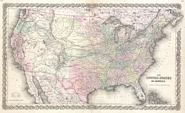
The United States of America
sold
- Digital Map Information
- Suitable for large format printing
- File Size: 18.02 MB
- File Type: ZIP / TIFF
- ICC color profile embedded
- Delivered instantly via download link
An excellent first edition example of Colton's rare map of the United States. Covers the United States from Coast to coast and shows a very early configuration of the Transmississippi. Nebraska is shown at its fullest, extending from Kansas to the ... (more details)

General Edition Decorative Map of Cape Cod. The Reaches of the Cape . . . Nantucket and Martha's Vineyard.
sold
- Digital Map Information
- Suitable for large format printing
- File Size: 10.63 MB
- File Type: ZIP / TIFF
- ICC color profile embedded
- Delivered instantly via download link
An extremely appealing 1940 decorative art deco map of Barnstable County, Massachusetts. Covers Cape Cod, Marthas Vineyard and Nantucket. Surrounded by images of historic sites throughout the region including Plymouth Rock, the Chatham Lighthouse, ... (more details)

Turkey in Europe.
sold
- Digital Map Information
- Suitable for large format printing
- DPI: 300
- File Size: 3.77 MB
- File Type: ZIP / TIFF
- ICC color profile embedded
- Delivered instantly via download link
A beautiful example of Finley's rare 1827 map of Turkey in Europe. Covers the European lands claimed by the Ottoman Empire in the early 19th century. This includes the modern day nations of Greece, Macedonia, Albania, Croatia, Bosnia, Serbia, ... (more details)

Holland.
sold
- Digital Map Information
- Suitable for large format printing
- DPI: 300
- File Size: 3.27 MB
- File Type: ZIP / TIFF
- ICC color profile embedded
- Delivered instantly via download link
A beautiful example of Finley's important 1827 map of Holland or the Netherlands. Covers the region Friesland south to Dutch Flanders and Brabant. Identifies numerous cities, river systems, swamps and canals. Title and scale in upper left ... (more details)

Palestine.
sold
- Digital Map Information
- Suitable for large format printing
- DPI: 300
- File Size: 3.38 MB
- File Type: ZIP / TIFF
- ICC color profile embedded
- Delivered instantly via download link
A beautiful example of Finley's important 1827 map of Palestine, Israel or the Holy Land. Covers the region from Sidon and Damascus in the north to the southern tip of the Dead Sea or Zoar. Includes the modern day nations of Israel, ... (more details)

Hindoostan.
sold
- Digital Map Information
- Suitable for large format printing
- Full resolution TIFF file
- ICC color profile embedded
- Delivered instantly via download link
A beautiful example of Finley's important 1827 map of India or Hindoostan. Covers the subcontinent from Luddock south to Ceylon (Sri Lanka). Identifies numerous cities, river systems, deserts, and mountain ranges. Includes parts of ... (more details)
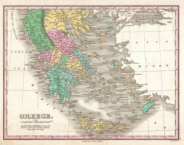
Greece.
sold
- Digital Map Information
- Suitable for large format printing
- Full resolution TIFF file
- ICC color profile embedded
- Delivered instantly via download link
A beautiful example of Finley's important 1827 map of Greece. Depicts from Macedonia to Greece and includes many of the Greek Islands. Shows cities, river ways, roads, monasteries, and some topographical features. Offers color coding ... (more details)

Germany.
sold
- Digital Map Information
- Suitable for large format printing
- DPI: 300
- File Size: 4.38 MB
- File Type: ZIP / TIFF
- ICC color profile embedded
- Delivered instantly via download link
A beautiful example of Finley's important 1827 map of Germany. Depicts from the North and Baltic Seas south to the Gulf of Venice. This is a map of 'Greater Germania,' including the disparate German republics, Prussia, Poland, ... (more details)

Russia in Asia.
sold
- Digital Map Information
- Suitable for large format printing
- DPI: 300
- File Size: 3.64 MB
- File Type: ZIP / TIFF
- ICC color profile embedded
- Delivered instantly via download link
A beautiful example of Finley's important 1827 map of Russia in Asia. Depicts from the Black Sea and Arabia eastward to the Behring Strait, northwards to the Arctic, and southwards to Chinese Tartary. Show rives, forests, ... (more details)

Asia.
sold
- Digital Map Information
- Suitable for large format printing
- DPI: 300
- File Size: 3.78 MB
- File Type: ZIP / TIFF
- ICC color profile embedded
- Delivered instantly via download link
A beautiful example of Finley's important 1827 map of Asia. Depicts from the Black Sea and Arabia eastward to the Behring Strait and Papua New Guinea. Includes Australia (New Holland) and the East India Islands with Asia, ... (more details)

Egypt.
sold
- Digital Map Information
- Suitable for large format printing
- DPI: 300
- File Size: 3.22 MB
- File Type: ZIP / TIFF
- ICC color profile embedded
- Delivered instantly via download link
A beautiful example of Finley's important 1827 map of Egypt. Depicts Egypt, centered on the Nile River, and extending south as far as Aswan. Names numerous settlements and villages along the course of the river, including ... (more details)
Africa on the cusp of European exploration into the interior.

Africa.
sold
- Digital Map Information
- Suitable for large format printing
- DPI: 300
- File Size: 3.49 MB
- File Type: ZIP / TIFF
- ICC color profile embedded
- Delivered instantly via download link
A beautiful example of Finley's important 1827 map of Africa. This uncommon map predates the explosion of African exploration that occurred in the mid 19h century. Much of the interior remains unknown. The Ptolemaic ... (more details)

Sketch E No. 2 Showing the progress of the Survey in the vicinity of Savannah Georgia 1850 - 52.
sold
- Digital Map Information
- Suitable for large format printing
- DPI: 300
- File Size: 1.88 MB
- File Type: ZIP / TIFF
- ICC color profile embedded
- Delivered instantly via download link
An attractive hand colored 1854 U.S. Coast Survey triangulation chart or map of Savannah Georgia and the Savannah River. Shows the progress of the survey work in this area by date annotated sections. Shows navigation ... (more details)

Patapsco River and the Approaches.
sold
- Digital Map Information
- Suitable for large format printing
- File Size: 15.21 MB
- File Type: ZIP / TIFF
- ICC color profile embedded
- Delivered instantly via download link
This is an uncommon 1856 U.S. Coast Survey Chart or Map of Patapsco River, the Chesapeake Bay, and approaches to Baltimore, Maryland. Covers from Baltimore in the northwest, eastward as far as Fairlee Creek, and ... (more details)
Outstanding wall map of the Russian Empire.

The European Part of the Russian Empire, from Maps Published by the Imperial Academy at St. Petersburg, with the New Provinces on the Black Sea. - The Asiatic Part of the Russian Empire from the Maps Published by the Imperial Academy of St. Petersburg, with the New Discoveries of Captian Cook & co.
sold
- Digital Map Information
- Suitable for large format printing
- DPI: 300
- File Size: 38.79 MB
- File Type: ZIP / TIFF
- ICC color profile embedded
- Delivered instantly via download link
A rare and magnificently proportioned 1794 wall map of the Russian Empire by Laurie and Whittle. Extends from the North Sea and the Black Sea eastward as far as Siberia and the Behring Strait. Extends south to ... (more details)
First appearance of Central Park in a commercial atlas map.
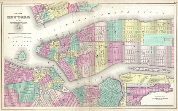
Map of New York and the Adjacent Cities.
sold
- Digital Map Information
- Suitable for large format printing
- File Size: 7.89 MB
- File Type: ZIP / TIFF
- ICC color profile embedded
- Delivered instantly via download link
A rare and beautiful example of J. H. Colton map of New York City and vicinity, including Manhattan as well as parts of Brooklyn, Jersey City, Hoboken, and Queens. This is the third state of this map and one ... (more details)