
Uncommon and attractive city map or plan of Barcelona, Spain.
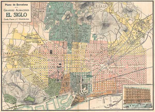
Plano de Barcelona de los Grandes Almacenes El Siglo.
sold
- Digital Map Information
- Suitable for large format printing
- File Size: 14.28 MB
- File Type: ZIP / TIFF
- ICC color profile embedded
- Delivered instantly via download link
This is a 1910 Conde, Puerto y Ca. map or plan of Barcelona, Spain. The map depicts from the Sans neighborhood in the seventh district and the Cementerio del Oeste on the left to the ninth district and the San Andrés neighborhood on the right and from the Sarriá ... (more details)
Beautiful 18th century map of Spain and Portugal.
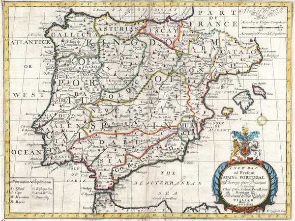
A New Map of Spain and Portugal. Showing their Principal Divisions, Chief Cities, Townes, Ports, Rivers, Mountains, etc.
sold
- Digital Map Information
- Suitable for large format printing
- DPI: 300
- File Size: 7.7 MB
- File Type: ZIP / TIFF
- ICC color profile embedded
- Delivered instantly via download link
This is a 1700 Edward Wells map of Spain and Portugal. The map depicts the Iberian Peninsula, where both Spain and Portugal and located, from the Bay of Biscay on the top to Morocco on the bottom and from the Atlantic Ocean on the left to the Mediterranean Sea on ... (more details)
Rare map showing the unoffiical Japanese settlement in Hongkou, Shanghai.

上海日本人街便筧. / Shanghai Japanese Streets and Vicinity.
sold
- Digital Map Information
- Suitable for large format printing
- File Size: 9.18 MB
- File Type: ZIP / TIFF
- ICC color profile embedded
- Delivered instantly via download link
A rare and fascinating Showa 14 or 1939 map of the Hongkou, pre-war Shanghai's unofficial Japanese Settlement. By 1939, the Japanese were the largest foreign ethnic group active in Shanghai. Most were concentrated in the Hongkou district, depicted here, just ... (more details)
Rare map of Shanghai with manuscript annotations relating to foreign concessions and the Battle of Shanghai.

大上海新地圖 / The New Map of Shanghai. / Dai Shanhai shinchizu.
sold
- Digital Map Information
- Suitable for large format printing
- File Size: 20.33 MB
- File Type: ZIP / TIFF
- ICC color profile embedded
- Delivered instantly via download link
This is a very scarce Sugie, Fusazō (杉江房造) map of Shanghai, China, issued on August 30 of 1937 (Showa 12) with manuscript annotations relating to the Battle of Shanghai. Centered on the Bund, the map covers central Shanghai. The Shanghai ... (more details)
Spectacular pictorial map of Korea and Manchuria illustrating Pre-War Japanese interest in the region's wealth of resources.
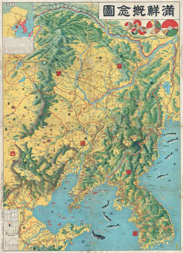
Conceptual Map of Manchuria and Korea. / 满鲜概念图
sold
- Digital Map Information
- Suitable for large format printing
- File Size: 35.53 MB
- File Type: ZIP / TIFF
- ICC color profile embedded
- Delivered instantly via download link
A spectacularly graphic 1930 or Showa 5 pictorial map of Korea and Manchuria. It covers all of Manchuria and Korea as well as parts of Shandong and Liaoning provinces, China. This map was created to illustrate railroads, regional port output, ... (more details)
Stunning 18th century map of Angers, France, in the heart of the Loire Valley wine region.
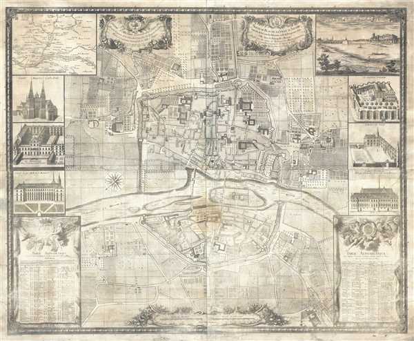
Nouveau Plan de la Ville d'Angers enrichi de la carte des environs et de la perspective de la ville avec ses principalles maisons. Dressé par les soins de Messieurs les Maires et Echevins et Conseillers perpetuels de l'Hotel de Ville.
sold
- Digital Map Information
- Suitable for large format printing
- DPI: 300
- File Size: 77.24 MB
- File Type: ZIP / TIFF
- ICC color profile embedded
- Delivered instantly via download link
This is an 1882 Lachèse and Dolbeau restrike of a 1736 Simon map of Angers, France. The restrike was done using the original 7 plates, which were in the archives of the Mairie d'Angers (the Angers City Hall). The map centers on Angers and ... (more details)
Scarce view of West Point Military Academy with flag at half-mast following the outbreak of the Amerrican Civil War.

View on the Hudson at West Point.
sold
- Digital Map Information
- Suitable for large format printing
- File Size: 18.55 MB
- File Type: ZIP / TIFF
- ICC color profile embedded
- Delivered instantly via download link
A rare c. 1862 Frederick Blumner lithograph view of the U.S. Military Academy at West Point and the Hudson River. The view looks out over the Hudson River towards the Military Academy from a high point on the Garrison side of the river, ... (more details)
Wonderful whimsical pictorial cartoon map of Harvard University and Radcliffe College.
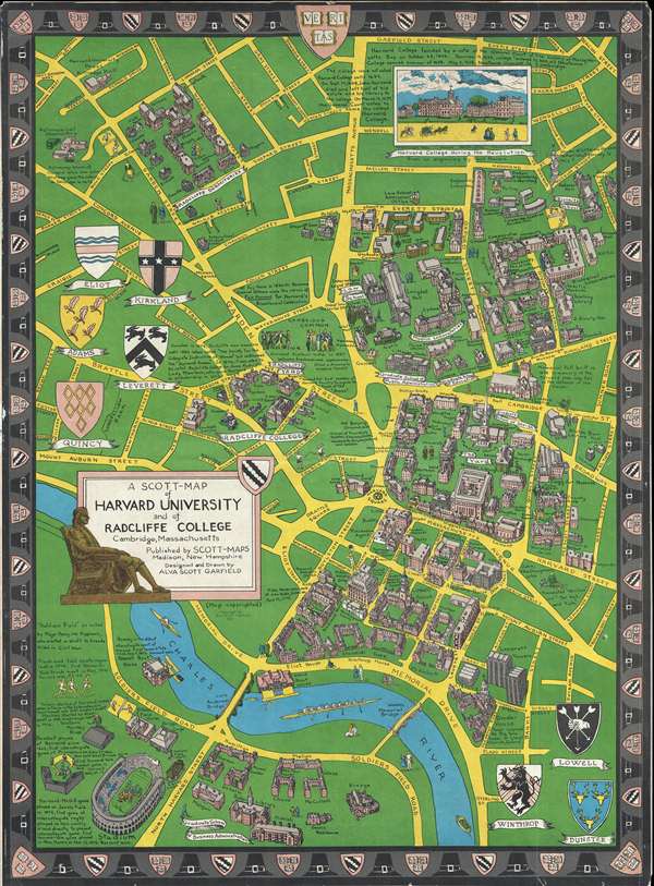
A Scott-Map of Harvard University and of Radcliffe College Cambridge, Massachusetts.
sold
- Digital Map Information
- Suitable for large format printing
- File Size: 26.55 MB
- File Type: ZIP / TIFF
- ICC color profile embedded
- Delivered instantly via download link
A delightfully whimiscal 1959 Alva Scott Garfield pictorial map Harvard University and Radcliffe College, Cambridge, Massachusetts (Boston). Centered on Harvard Square and presented from an acute 'view' perspective, this map covers Cambridge in the vicinity of Harvard and parts of adjacent Alston. Iconic Harvard buildings are identified throughout, including Radcliffe Dormitories, Physics Laboratories, Law School, Graduate School of Business Administration, Stadium, Lowell House and Memorial Hall. There are also numerous fascinating annotations, such as commentary in the lower left describing the history of intercollegiate rugby, baseball, and hockey - often boasting of Harvard victories. A vignette in the upper right, based upon a drawing by Paul Revere, reveals how Harvard appeared during the American Revolutionary War. Surrounding the map are armorial crests identifying the founding fathers of Boston. The crests of the various colleges are shown, and the University Veritas crest and pilgrim hats decorate the border. (more details)
Shocking map of Washington, D.C. depicting fatal cases of consumption.

No. V. Map of the City of Washington Showing Location of Fatal Cases of Consumption for the Year Ended June 30, 1901.
sold
- Digital Map Information
- Suitable for large format printing
- File Size: 16.94 MB
- File Type: ZIP / TIFF
- ICC color profile embedded
- Delivered instantly via download link
A fascinating 1901 Norris Peters map of Washington D.C. illustrating fatal cases of consumption (tuberculosis). This large map covers from the Rock Creek Cemetery to Haines Point and from Georgetown to the Anacostia River. City Blocks ... (more details)
Compelling map of Washington, D.C. depicting fatal cases of diphtheria and scarlet fever.
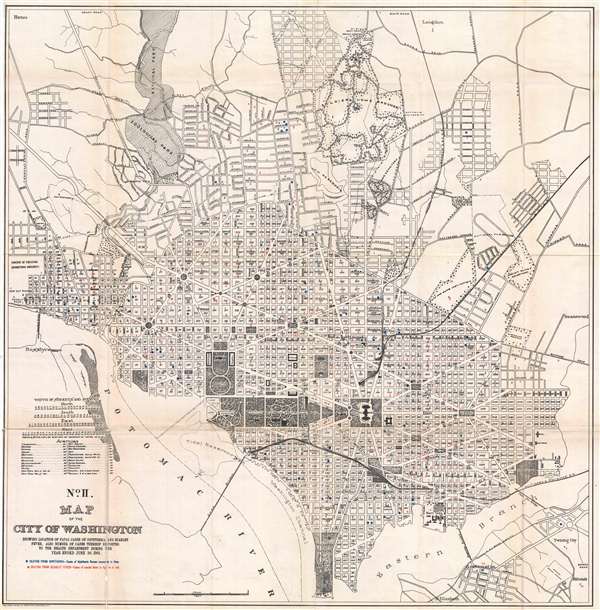
No. II. Map of the City of Washington Showing Location of Fatal Cases of Diphtheria and Scarlet Fever, also Number of Cases Thereof Reported to the Health Department During the Year Ended June 30, 1901.
sold
- Digital Map Information
- Suitable for large format printing
- File Size: 18.19 MB
- File Type: ZIP / TIFF
- ICC color profile embedded
- Delivered instantly via download link
A fascinating 1901 Norris Peters map of Washington D.C. illustrating fatal cases of diphtheria and scarlet fever, as well as the number of cases reported. This large map covers from the Rock Creek Cemetery to Haines Point and from ... (more details)
Fascinating map of Washington, D.C. depicting fatal cases of typhoid fever and malaria.

No. I. Map of the City of Washington Showing Location of Fatal Cases of Zymotic Diseases for the Year Ended June 30, 1901.
sold
- Digital Map Information
- Suitable for large format printing
- File Size: 16.76 MB
- File Type: ZIP / TIFF
- ICC color profile embedded
- Delivered instantly via download link
A fascinating 1901 Norris Peters map of Washington D.C. illustrating fatal cases of zymotic diseases, 'typhoid fever' and 'malarial fever'. This large map covers from the Rock Creek Cemetery to Haines Point and from Georgetown to ... (more details)
Incredible city map or plan of Washington, D.C.
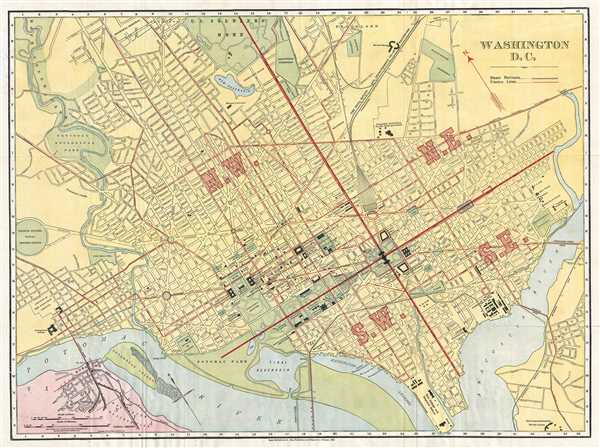
Washington D.C.
sold
- Digital Map Information
- Suitable for large format printing
- File Size: 17.58 MB
- File Type: ZIP / TIFF
- ICC color profile embedded
- Delivered instantly via download link
This is a beautiful 1910 map or plan of Washington D.C. by Rand McNally and Company. It covers Washington D.C. from the Potomac River to the Anacostia River and north to the U.S. Soldier's Home. The map is exceptionally detailed, ... (more details)
Wonderful early highway map of California.

Clason's Map of California.
sold
- Digital Map Information
- Suitable for large format printing
- File Size: 28.85 MB
- File Type: ZIP / TIFF
- ICC color profile embedded
- Delivered instantly via download link
A large and highly detailed c. 1920 pocket format map of California by the Clason Map Company. This map covers the entire stain of California with green highlighting to distinguish county borders and national forest lands. Inset submaps in the upper right and lower left quadrants focus on the San Francisco Bay area and the vicinity of Los Angeles, respectively. An index set along the map's left-hand border offers population statistics and a key to various cities throughout the state. (more details)
Uncommon Ottoman-Turkish map of the West Indies.

[West Indies]
sold
- Digital Map Information
- Suitable for large format printing
- File Size: 4.09 MB
- File Type: ZIP / TIFF
- ICC color profile embedded
- Delivered instantly via download link
This is an 1893 Ottoman-Turkish map of the West Indies. Centered on the Antilles, the map depicts from the Yucatan Peninsula to Trinidad and Tobago and Venezuela and from southern Florida to Colombia and Venezuela. Cuba, Haiti, ... (more details)
A splendid and highly graphic pictorial map of Paris and its monuments once owned by an American World War I soldier.

Paris Monumental et Métropolitain.
sold
- Digital Map Information
- Suitable for large format printing
- File Size: 17.4 MB
- File Type: ZIP / TIFF
- ICC color profile embedded
- Delivered instantly via download link
This extremely appealing c. 1913 pocket map of Paris France by Robelin, combines the virtues of a map and a view. Designed with the tourist in mind, this map covers the embastilled center of Paris and its immediate vicinity. ... (more details)
Incredible 1876 view of the Palais de Trocadéro in Paris, built for the 1878 Exposition Universelle.

Paris. - Exposition universelle de 1878. - Façade du Palais de Trocadéro.
sold
- Digital Map Information
- Suitable for large format printing
- File Size: 14.49 MB
- File Type: ZIP / TIFF
- ICC color profile embedded
- Delivered instantly via download link
This is an 1876 Clerget view of the Palais de Trocadéro from the 1878 Exposition Universelle (World's Fair) in Paris. This view shows the façade of the Palais du Trocadéro as it would have been seen from the Champ de Mars. ... (more details)
Detailed and attractive map of Florida Keys.

Legare Anchorage, Florida Reefs.
sold
- Digital Map Information
- Suitable for large format printing
- File Size: 6.75 MB
- File Type: ZIP / TIFF
- ICC color profile embedded
- Delivered instantly via download link
This is a hand colored 1857 U.S. Coast Survey chart of the Florida Keys. The map depicts Ragged Key, Sands' Key, and Elliot's Key and the Atlantic Ocean to the east of the Keys. A small portion of the Bay of Biscayne is shown ... (more details)
Detailed and attractive map of the Florida Keys and Key West.

Preliminary Chart of Florida Reefs Showing the Approaches to Key West Harbor.
sold
- Digital Map Information
- Suitable for large format printing
- File Size: 5.62 MB
- File Type: ZIP / TIFF
- ICC color profile embedded
- Delivered instantly via download link
This is a hand colored 1857 U.S. Coast Survey chart of the Florida Keys. The map depicts the approaches to Key West harbor from Cudjoe Key and Sugarloaf Key past Key West to Marquesas Keys and from just north of Sugarloaf Key ... (more details)
Attractive city map or plan of Venice, Italy.
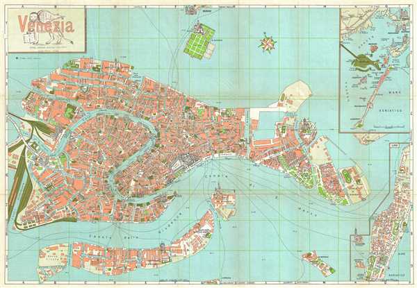
Venezia.
sold
- Digital Map Information
- Suitable for large format printing
- File Size: 11.87 MB
- File Type: ZIP / TIFF
- ICC color profile embedded
- Delivered instantly via download link
This is a 1961 Ettore Augusto Adriano Vincitorio tourist map of Venice, Italy. The map depicts the entire city of Venice, from the train station to the Isola di S. Elena and from the Zattere ai Gesuati to the Quartiere ... (more details)
Highly detailed post-WWII city map or plan of Rome, Italy.
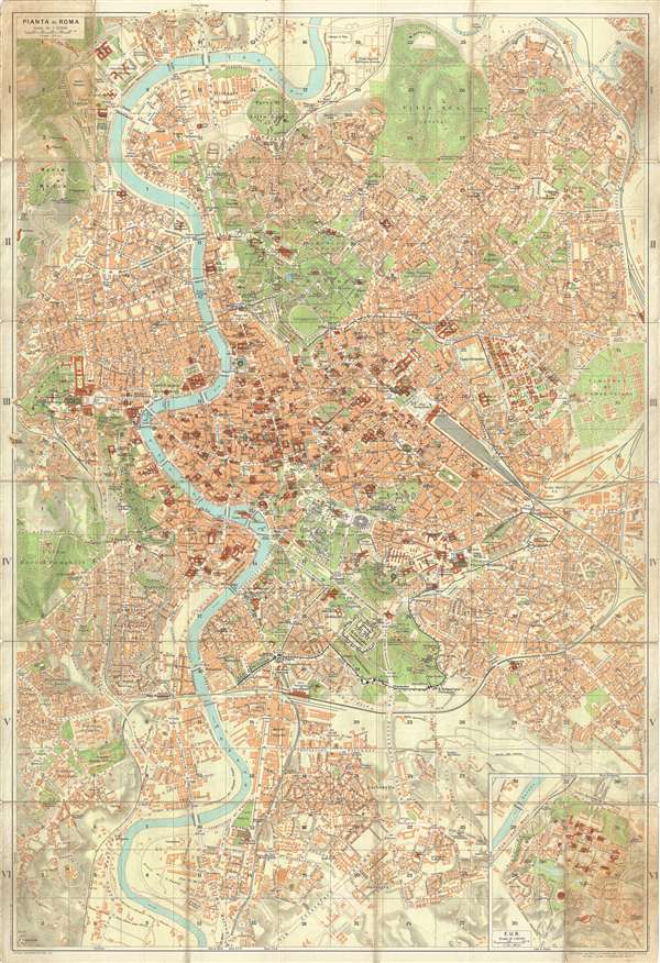
Pianta di Roma.
sold
- Digital Map Information
- Suitable for large format printing
- File Size: 24.04 MB
- File Type: ZIP / TIFF
- ICC color profile embedded
- Delivered instantly via download link
This is a 1962 Touring Club Italiano tourist map of Rome, Italy. The map is oriented to the north and depicts from the Villa Ada to the Via Cristoforo Colombo and from the Vatican on the left to the Cimitero di Campo ... (more details)