

Johnson's Ireland. Johnson's Scotland.
sold
- Digital Map Information
- Suitable for large format printing
- File Size: 18.84 MB
- File Type: ZIP / TIFF
- ICC color profile embedded
- Delivered instantly via download link
This is a beautiful example of A. J. Johnson and R. Browning's 1861 map of Scotland and Ireland. It contains two separate maps within the same border. The left hand map features Ireland and covers the entire emerald Isle in full from Donegal to Cork. Ireland is ... (more details)

Johnson's Brazil Argentine Republic, Paraguay and Uruguay.
sold
- Digital Map Information
- Suitable for large format printing
- File Size: 8.77 MB
- File Type: ZIP / TIFF
- ICC color profile embedded
- Delivered instantly via download link
This is a beautiful example of A. J. Johnson and R. Browning's 1861 map of Brazil, the Argentine Republic (northern Argentina), Paraguay and Uruguay. It offers excellent detail both along the coast and inland, especially along navigable rivers. Shows most of ... (more details)
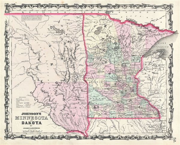
Johnson's Minnesota and Dakota.
sold
- Digital Map Information
- Suitable for large format printing
- File Size: 7.73 MB
- File Type: ZIP / TIFF
- ICC color profile embedded
- Delivered instantly via download link
This is a beautiful example of A. J. Johnson and R. Browning's 1861 map of Minnesota and Dakota. It covers both states as well as adjacent parts of Wisconsin and Iowa. This map predates the splitting of the Dakotas and instead depicts them as a single great ... (more details)
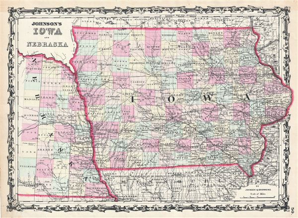
Johnson's Iowa and Nebraska.
sold
- Digital Map Information
- Suitable for large format printing
- File Size: 10.38 MB
- File Type: ZIP / TIFF
- ICC color profile embedded
- Delivered instantly via download link
This is a beautiful example of A. J. Johnson and R. Browning's 1861 map of Iowa and Nebraska. It covers the entire state of Iowa as well as the eastern portions of Nebraska. The map is color coded according to county and notes several towns, cities, rivers, ... (more details)

Johnson's Illinois.
sold
- Digital Map Information
- Suitable for large format printing
- File Size: 10.93 MB
- File Type: ZIP / TIFF
- ICC color profile embedded
- Delivered instantly via download link
This is a beautiful example of A. J. Johnson and R. Browning's 1861 map of Illinois. It covers the entire state as well as portions of the adjacent states of Iowa, Missouri and Indiana. The map is color coded according to county and notes several towns, ... (more details)

Johnson's Ohio and Indiana.
sold
- Digital Map Information
- Suitable for large format printing
- File Size: 20.96 MB
- File Type: ZIP / TIFF
- ICC color profile embedded
- Delivered instantly via download link
This is a beautiful example of A. J. Johnson and R. Browning's 1861 map of Ohio and Indiana. It covers both states divided into counties with special attention to transportation, especially roads, railroads, and canals. There is an engraved view of the ... (more details)

Johnson's Maine.
sold
- Digital Map Information
- Suitable for large format printing
- File Size: 9.79 MB
- File Type: ZIP / TIFF
- ICC color profile embedded
- Delivered instantly via download link
This is a beautiful example of A. J. Johnson and R. Browning's 1861 map of Maine. It covers the entire state along with portions of adjacent Canada and New Hampshire. The map is color coded according to county and notes several towns, cities, rivers, ... (more details)

Johnson's France. Johnson's Holland and Belgium.
sold
- Digital Map Information
- Suitable for large format printing
- File Size: 17.27 MB
- File Type: ZIP / TIFF
- ICC color profile embedded
- Delivered instantly via download link
This is a beautiful example of A. J. Johnson and R. Browning's 1861 map of France, Holland (the Netherlands) and Belgium. The map is divided into two separate maps within the same border. The left hand map focuses on France subdivided according to ... (more details)

Johnson's Prussia Norway, Sweden and Denmark.
sold
- Digital Map Information
- Suitable for large format printing
- File Size: 18.37 MB
- File Type: ZIP / TIFF
- ICC color profile embedded
- Delivered instantly via download link
This is a beautiful example of A. J. Johnson and R. Browning's 1861 map of Scandinavia and Prussia. It depicts all of Sweden, Norway, Finland, Denmark and Prussia, as well as parts of estonia, Latvia and Lithuania. There are two decorative city ... (more details)

Johnson's Map of The World Showing the Geographical Distribution & Range of The Principal Members of The Animal Kingdom. Johnson's Map of The World Illustrating the Productive Industry and exhibiting the principal features of Commerce And Navigation. Johnson's Map Showing the Principal Ocean Currents and Boundaries of the River Systems.
sold
- Digital Map Information
- Suitable for large format printing
- File Size: 8.04 MB
- File Type: ZIP / TIFF
- ICC color profile embedded
- Delivered instantly via download link
This is one of the thematic world map sets from the rare 1864 edition of Johnson and Ward's New Illustrated Atlas . It features three maps within a single border. The first map depicts the geographical distribution and range of the principal ... (more details)

Johnson's Map Illustrating the Principal Features of Meteorology. Johnson's Map Illustrating the Principal Features of the Land and the Co-tidal Lines. Johnson's Map Showing the Distribution and Limits of Cultivation of the Principal Plants Useful to Mankind.
sold
- Digital Map Information
- Suitable for large format printing
- File Size: 8.89 MB
- File Type: ZIP / TIFF
- ICC color profile embedded
- Delivered instantly via download link
This is one of the thematic world map sets from the rare 1864 edition of Johnson and Ward's New Illustrated Atlas . It features three maps within a single border. The first map depicts the world's meteorological patterns and includes an ... (more details)

Johnson's Maine.
sold
- Digital Map Information
- Suitable for large format printing
- File Size: 9.85 MB
- File Type: ZIP / TIFF
- ICC color profile embedded
- Delivered instantly via download link
This is Johnson and Ward's 1864 map of Maine. It covers the entire state along with portions of adjacent Canada and New Hampshire. The map is color coded according to county and notes several roads, railways, rivers, cities, towns and ... (more details)

Johnson's Austria, Turkey In Europe And Greece.
sold
- Digital Map Information
- Suitable for large format printing
- File Size: 21.07 MB
- File Type: ZIP / TIFF
- ICC color profile embedded
- Delivered instantly via download link
This is a beautiful example of Johnson and Ward's 1865 map of Austria, Turkey in europe and Greece. It covers from Italy eastward to include all of Austria, Hungary, the Balkans (Bosnia, Serbia, Albania, Croatia, Macedonia, Bulgaria, ... (more details)
A hand drawn manuscript map - most likely the first accurate nautical chart of west Sumatra's Pepper Coast.

Cartes de principales Rades and Marchés à poivre dans la partie Nord de la Cote Ouest De Sumatra Par Samuel Ashmore.
sold
- Digital Map Information
- Suitable for large format printing
- DPI: 300
- File Size: 10.71 MB
- File Type: ZIP / TIFF
- ICC color profile embedded
- Delivered instantly via download link
Drawn by Australian-Irish sea captain Samuel Ashmore, this important and one of a kind 1821 manuscript (hand drawn) nautical chart or maritime map is the first accurate depiction of the pepper ports of northwestern Sumatra, modern day ... (more details)
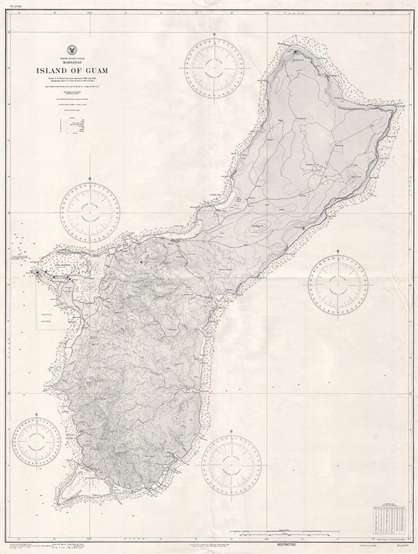
North Pacifc Ocean Marianas Island of Guam.
sold
- Digital Map Information
- Suitable for large format printing
- File Size: 38.22 MB
- File Type: ZIP / TIFF
- ICC color profile embedded
- Delivered instantly via download link
This is a scarce World War II (WWII) era 1945 map of Guam issued by the U.S. Navy Hydrographic Office shortly after the 1944 recapture of the island by U.S. military forces. Guam, long an important stopping point for trans-Pacific ... (more details)
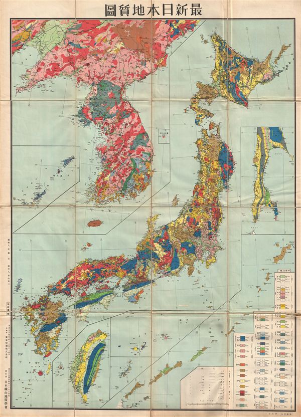
Latest All Japan Geology Map.
sold
- Digital Map Information
- Suitable for large format printing
- File Size: 39 MB
- File Type: ZIP / TIFF
- ICC color profile embedded
- Delivered instantly via download link
A scarce and attractive 1940 or Showa 15 geological map of Japan, including the annexed territories of Korea (Corea) and Taiwan. Issued by the Japan Mineral Geology Association, this map offers beautiful detail of the entire ... (more details)

A New Chart of the World, on Mercator's Projection: Exhibiting the Track & Discoveries of themost Eminent Navigators, to the Present Period.
sold
- Digital Map Information
- Suitable for large format printing
- DPI: 300
- File Size: 16.1 MB
- File Type: ZIP / TIFF
- ICC color profile embedded
- Delivered instantly via download link
A very nice example of John Cary's wonderful 1801 Map of the World on Mercator's Projection. Details the entire world as it was known at the turn of the 19th century. Displays the continents in considerable detail but ... (more details)
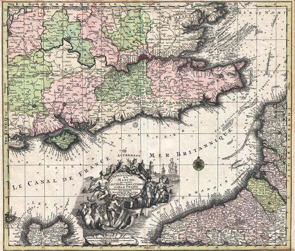
La Plus Grande Partie de la Manche, qui continent Les Cotes D'Angleterre et cells de France les Bords Maritimes de Picardie.
sold
- Digital Map Information
- Suitable for large format printing
- Full resolution TIFF file
- ICC color profile embedded
- Delivered instantly via download link
A highly decorative c. 1730 map of the english Channel, southeastern england, and the coasts of Normandy by Matthius Seutter. The map covers southeastern england, including London and the full length of the Thames ... (more details)
1908 U.S. Coast Survey Map of South Florida, the Florida Keys, North Cuba, and the Great Bahama Bank
Scarce nautical chart of the Florida Keys, Florida Strait, Northern Cuba, and the Great Bahama Bank.
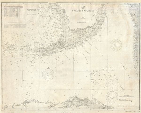
Straits of Florida.
sold
- Digital Map Information
- Suitable for large format printing
- File Size: 37.02 MB
- File Type: ZIP / TIFF
- ICC color profile embedded
- Delivered instantly via download link
A scarce 1908 U.S. Coast Survey nautical chart or maritime map of the Straits of Florida. The map covers from Miami and Biscayne Bay south as far as northern Cuba and Havana (Habana), east as far as the Great ... (more details)
Scarce nautical chart of the middle part of the Florida Keys.

Coast Chart No. 168 Florida Reefs From Long Key to Newfound Harbor Key.
sold
- Digital Map Information
- Suitable for large format printing
- File Size: 53.22 MB
- File Type: ZIP / TIFF
- ICC color profile embedded
- Delivered instantly via download link
A scarce 1908 U.S. Coast Survey nautical chart or maritime map of the middle Florida Keys and Florida Bay. The map covers from Long Key to Newfound Harbor Key, and includes Torch Key, Big Pine Key, No Name ... (more details)