

Italien nach seiner kirchlichen Eintheilung.
sold
- Digital Map Information
- Suitable for large format printing
- DPI: 300
- File Size: 11.46 MB
- File Type: ZIP / TIFF
- ICC color profile embedded
- Delivered instantly via download link
This is Karl von Spruner's 1854 historical map of Italy and its ecclesiastical divisions. The map covers all of Italy divided into provinces from the area of Venice to Malta, including the islands of Sicily, Corsica, and Sardinia. The map additionally features ... (more details)
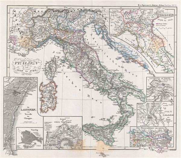
Italien von 1450 bis 1792.
sold
- Digital Map Information
- Suitable for large format printing
- DPI: 300
- File Size: 13.05 MB
- File Type: ZIP / TIFF
- ICC color profile embedded
- Delivered instantly via download link
This is Karl von Spruner's 1854 historical map of Italy from 1450 to 1792. The map covers all of Italy from the area of Venice to Malta, including the islands of Sicily, Corsica, and Sardinia. The map also features seven inset maps, one on the top right ... (more details)

Byzantinische Reich, ostliches Blatt.
sold
- Digital Map Information
- Suitable for large format printing
- DPI: 300
- File Size: 13.93 MB
- File Type: ZIP / TIFF
- ICC color profile embedded
- Delivered instantly via download link
This is Karl von Spruner's 1854 historical map of Asia Minor, Iran, Iraq, and the Caucuses during the hegemony of the Byzantine empire. The map covers from Georgia south to Syria and includes the modern day countries of Turkey, Syria, Georgia, Armenia, ... (more details)

Das russische Reich nach seiner allmaehligen Vergrösserung.
sold
- Digital Map Information
- Suitable for large format printing
- DPI: 300
- File Size: 10.53 MB
- File Type: ZIP / TIFF
- ICC color profile embedded
- Delivered instantly via download link
This is Karl von Spruner's 1854 historical map of the Russia empire following its gradual transcontinental expansion in the 18th century. The map covers from the Arctic Ocean south to China, and from Sweden to North America. An inset map on the bottom ... (more details)
Appealing view of New York City.

New York and Environs.
sold
- Digital Map Information
- Suitable for large format printing
- File Size: 8.22 MB
- File Type: ZIP / TIFF
- ICC color profile embedded
- Delivered instantly via download link
A stunning and rare 1868 view of the island of Manhattan, New York City by W. C. Rogers. View depicts the entire island of Manhattan with Hoboken as well as parts of Brooklyn and Queens. Important buildings, especially churches are depicted with ... (more details)

Sketch B. No. 2 Showing the Triangulation & Geographical Positions in Section No. II From New York City to Point Judith.
sold
- Digital Map Information
- Suitable for large format printing
- DPI: 300
- File Size: 15.29 MB
- File Type: ZIP / TIFF
- ICC color profile embedded
- Delivered instantly via download link
An exceptional example of the 1851 U.S. Coast Survey's progress nautical and triangulation chart for Long Island, New York. Covers from Staten Island and New York City eastward along Long Island and the coast of Connecticut to Block Island and ... (more details)

Johnson’s Northern Italy, Lombardy, Venice, Sardinia, Tuscany, Parma, Modena, Lucca, and the States of the Church. / Johnson’s Southern Italy, Kingdom of Naples, I. Sardinia & Malta.
sold
- Digital Map Information
- Suitable for large format printing
- File Size: 56.87 MB
- File Type: ZIP / TIFF
- ICC color profile embedded
- Delivered instantly via download link
A marvelous 1861 map of Italy by the American cartographic publisher A. J. Johnson. Depicts the Italian peninsula in the midst of its struggle for national solidarity. The map is divided into two sections – northern Italy and southern Italy ... (more details)

Johnson's Japan Nippon, Kiusiu, Sikok, Yesso and the Kuriles.
sold
- Digital Map Information
- Suitable for large format printing
- File Size: 12.94 MB
- File Type: ZIP / TIFF
- ICC color profile embedded
- Delivered instantly via download link
A very nice first edition example of A. J. Johnson and Ross C. Browning's 1861 map of Japan. Covers the Japanese Islands from Kyushu north to Yesso (Hokkaido). Offers considerable detail with color cording according to province. An inset map ... (more details)

Griechenland und Kleinasien bis zur Eroberung Konstantinopel's durch die Osmannen am 29ten May 1453.
sold
- Digital Map Information
- Suitable for large format printing
- DPI: 300
- File Size: 29.07 MB
- File Type: ZIP / TIFF
- ICC color profile embedded
- Delivered instantly via download link
This is Karl von Spruner's 1854 historical map of Greece and Asia Minor (Turkey) at the Fall of Constantinople, May 29, 1453. The map coves Greece and Turkey from Bulgaria in the north to Crete and Cyprus in the south and as far as the ... (more details)

Griechenland und Kleinasien vom XIten bis in die Mitte des XIIIten Jhdts.
sold
- Digital Map Information
- Suitable for large format printing
- DPI: 300
- File Size: 26.13 MB
- File Type: ZIP / TIFF
- ICC color profile embedded
- Delivered instantly via download link
This is Karl von Spruner's 1854 historical map of Greece and Asia Minor (Turkey) from the 11th to the mid-13th century. The map coves Greece and Turkey from Bulgaria in the north to Crete and Cyprus in the south and as far as Armenia ... (more details)
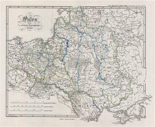
Polen bis zu seinem Untergange 1795.
sold
- Digital Map Information
- Suitable for large format printing
- DPI: 300
- File Size: 22.39 MB
- File Type: ZIP / TIFF
- ICC color profile embedded
- Delivered instantly via download link
This is Karl von Spruner's 1854 historical map of Poland from the first Partition of Poland in 1772, through the Second and Third Partitions, to the dissolution of the Polish-Lithuanian Commonwealth in 1795. The map coves Poland from ... (more details)

Polen und Litthauen unter den Jagjellonen 1386-1572.
sold
- Digital Map Information
- Suitable for large format printing
- DPI: 300
- File Size: 22.26 MB
- File Type: ZIP / TIFF
- ICC color profile embedded
- Delivered instantly via download link
This is Karl von Spruner's 1854 historical map of Poland and Lithuania under the Jagiellon Dynasty, 1387 to 1572. The map covers Poland and Lithuania from estonia in the north to Moldavia in the south. The 1385 Union of Krewo, or ... (more details)

Polen und Litthauen von 1125 bis zu ihrer Vereinigung 1386.
sold
- Digital Map Information
- Suitable for large format printing
- DPI: 300
- File Size: 23.52 MB
- File Type: ZIP / TIFF
- ICC color profile embedded
- Delivered instantly via download link
This is Karl von Spruner's 1854 historical map of Poland and Lithuania from 1125 until its unification in 1386. The map covers Poland and Lithuania from Nowgorod to Chazaria, detailing a time when Lithuania was the largest country ... (more details)

Die Völker und Reiche der Slaven zwischen Elbe und Don bis 1125.
sold
- Digital Map Information
- Suitable for large format printing
- DPI: 300
- File Size: 23.73 MB
- File Type: ZIP / TIFF
- ICC color profile embedded
- Delivered instantly via download link
This is Karl von Spruner's 1854 historical map of the Slavic Kingdoms between the elbe and Don Rivers to 1125. The map covers modern day Poland, Slovakia, Lithuania, Ukraine and parts of the Russian Federation. The map details a ... (more details)

Die Besitzungen der Spanier und Portugiesen im XVIten Jahrhundert.
sold
- Digital Map Information
- Suitable for large format printing
- DPI: 300
- File Size: 22.56 MB
- File Type: ZIP / TIFF
- ICC color profile embedded
- Delivered instantly via download link
This is Karl von Spruner's 1854 historical map of the world detailing the possessions of the Spaniards and the Portuguese in the 16th century. The map covers the entire world with Spanish and Portuguese territorial boundaries ... (more details)

Syrien und die angraenzenden Laender zur zeit der Kreuzzuge.
sold
- Digital Map Information
- Suitable for large format printing
- DPI: 300
- File Size: 26.88 MB
- File Type: ZIP / TIFF
- ICC color profile embedded
- Delivered instantly via download link
This is Karl von Spruner's 1854 historical map of Israel, Palestine or the Holy Land, and the adjacent regions at the time of the Crusades. The map covers from southern Turkey to egypt's Nile Delta, inclusive of Cyprus, and ... (more details)

Kalifat. Oestliche Haelfte.
sold
- Digital Map Information
- Suitable for large format printing
- DPI: 300
- File Size: 27.11 MB
- File Type: ZIP / TIFF
- ICC color profile embedded
- Delivered instantly via download link
This is Karl von Spruner's 1854 historical map of the Arabia, Afghanistan, and Persia. The map covers from the Red Sea to Afghanistan and from the Caspian Sea to the horn of Africa and Northern India. Two inset maps on the ... (more details)

Grossbritanniens saemmtliche Besitzungen mit Angabe ihrer Erwerbungszeit.
sold
- Digital Map Information
- Suitable for large format printing
- DPI: 300
- File Size: 28.9 MB
- File Type: ZIP / TIFF
- ICC color profile embedded
- Delivered instantly via download link
This is Karl von Spruner's 1854 historical map of the World detailing the British empire, of which it was once factually said, 'the sun never sets.' The map covers the entire world with Britain's territorial and colonial ... (more details)

Metomkin Inlet Virginia.
sold
- Digital Map Information
- Suitable for large format printing
- File Size: 11.85 MB
- File Type: ZIP / TIFF
- ICC color profile embedded
- Delivered instantly via download link
An appealing hand colored 1862 U.S. Coast Survey nautical chart or maritime map of Metompkin Inlet, Virginia. The map covers from Metompkin Inlet to Metompkin Bay, as well as the adjacent creeks and estuaries. Countless ... (more details)
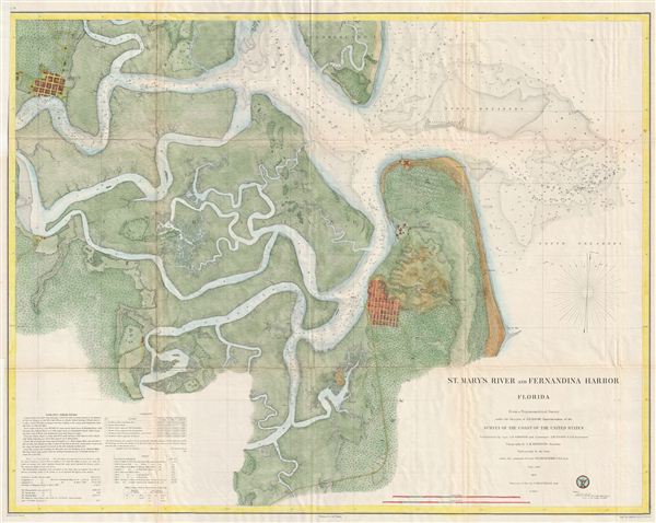
St. Mary's River and Fernandina Harbor Florida.
sold
- Digital Map Information
- Suitable for large format printing
- File Size: 32.27 MB
- File Type: ZIP / TIFF
- ICC color profile embedded
- Delivered instantly via download link
An attractive hand colored 1857 U.S. Coast Survey sea chart or map depicting St. Mary's River and Fernandina Harbor in northern Florida. Details the winding course of the St. Mary River Delta from St. Mary's to the ... (more details)