
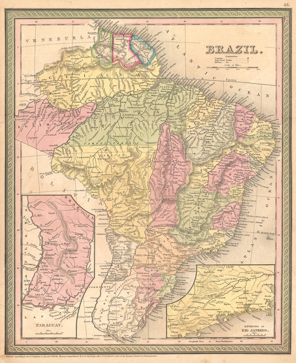
Brazil.
sold
- Digital Map Information
- Suitable for large format printing
- DPI: 300
- File Size: 13.39 MB
- File Type: ZIP / TIFF
- ICC color profile embedded
- Delivered instantly via download link
A nice example of S. A. Mitchell's 1850 map of Brazil and Paraguay. This map depicts the eastern part of South American including the Guianas, Brazil ( Brasil ) and Paraguay. Features impressive detail of the amazon basin and the interior of Brazil. Inset of the ... (more details)
County Map of Texas and Indian Territory.
sold
- Digital Map Information
- Suitable for large format printing
- File Size: 5.08 MB
- File Type: ZIP / TIFF
- ICC color profile embedded
- Delivered instantly via download link
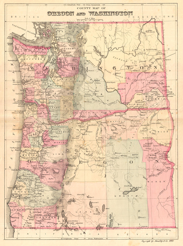
This is an attractive county map of Washington and Oregon, showing counties in light pastels, roads, rivers, and relief shown by fine hachures. By William M. Bradley, from his Bradley's Alas of the World for Commercial and Library Reference , ... (more details)
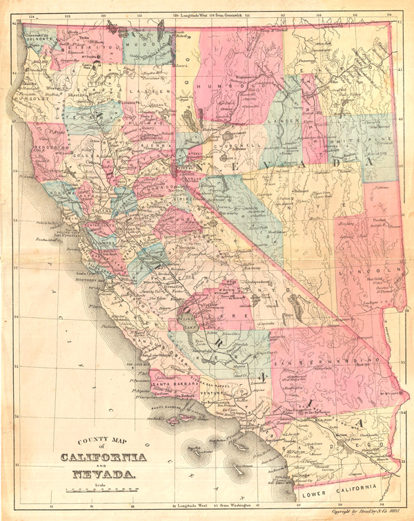
County Map of California and Nevada.
sold
- Digital Map Information
- Suitable for large format printing
- File Size: 5.84 MB
- File Type: ZIP / TIFF
- ICC color profile embedded
- Delivered instantly via download link
This is an attractive county map of California and Nevada, showing counties in light pastels, roads, rivers, and relief shown by fine hachures. By William M. Bradley, from his Bradley's Alas of the World for Commercial and Library Reference , ... (more details)

County Map of Dakota and Nebraska.
sold
- Digital Map Information
- Suitable for large format printing
- File Size: 5.85 MB
- File Type: ZIP / TIFF
- ICC color profile embedded
- Delivered instantly via download link
This is an attractive county map of what later become North and South Dakota, and Nebraska, showing counties in light pastels, roads, rivers, and relief shown by fine hachures. Predates the separation of Dakota into northern and southern ... (more details)
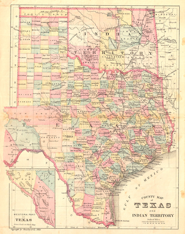
County Map of Texas and Indian Territory.
sold
- Digital Map Information
- Suitable for large format printing
- File Size: 5.83 MB
- File Type: ZIP / TIFF
- ICC color profile embedded
- Delivered instantly via download link
This is an attractive county map of Texas and the Indian Territory (Oklahoma), showing counties in light pastels, roads, rivers, and relief shown by fine hachures. An inset in the lower right focuses on the western part of Texas. By ... (more details)
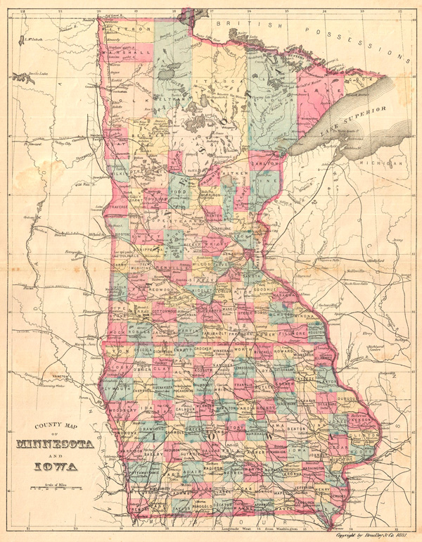
County Map of Minnesota and Iowa.
sold
- Digital Map Information
- Suitable for large format printing
- File Size: 5.43 MB
- File Type: ZIP / TIFF
- ICC color profile embedded
- Delivered instantly via download link
This is an attractive county map of Minnesota and Iowa, showing counties in light pastels, roads, rivers, and relief shown by fine hachures. By William M. Bradley, from his Bradley's Alas of the World for Commercial and Library ... (more details)

County Map of Arizona and New Mexico.
sold
- Digital Map Information
- Suitable for large format printing
- File Size: 5.08 MB
- File Type: ZIP / TIFF
- ICC color profile embedded
- Delivered instantly via download link
This is an attractive county map of Arizona and New Mexico showing counties in light pastels, roads, rivers, and relief shown by fine hachures. By William M. Bradley, from his Bradley's Alas of the World for Commercial and ... (more details)
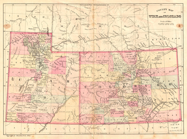
County Map of Utah and Colorado.
sold
- Digital Map Information
- Suitable for large format printing
- File Size: 5.01 MB
- File Type: ZIP / TIFF
- ICC color profile embedded
- Delivered instantly via download link
This is an attractive county map of Utah and Colorado featuring light pastels, roads, rivers, and relief shown by fine hachures. By William M. Bradley, from his Bradley's Alas of the World for Commercial and Library ... (more details)
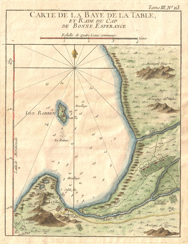
Carte De La Baye De La Table et Rade Du Cap De Bonne Esperance.
sold
- Digital Map Information
- Suitable for large format printing
- Full resolution TIFF file
- ICC color profile embedded
- Delivered instantly via download link
This hand colored map is a c. 1764 map of the Cape of Good Hope and Cape Town, South Africa. Attributed to French cartographer Jacques-Nicholas Bellin, this map was issued both in Bellin's Le Petit Atlas Maritime ... (more details)

A Map of the Colonies of the Descendants of Ham
sold
- Digital Map Information
- Suitable for large format printing
- DPI: 300
- File Size: 3.27 MB
- File Type: ZIP / TIFF
- ICC color profile embedded
- Delivered instantly via download link
This is a gorgeously colored c. 1790 map that purports to show the colonies of the descendants of Ham. Ham appears in Genesis where he is of the sons of Noah. Following the flood Ham walks into Noah's tent and ... (more details)

A Diagram Exhibiting the differences of time between the places shown & Washington
sold
- Digital Map Information
- Suitable for large format printing
- File Size: 12.58 MB
- File Type: ZIP / TIFF
- ICC color profile embedded
- Delivered instantly via download link
An extremely interesting, attractive c. 1864 diagram with five concentric rings of clocks showing the time differences between Washington and cities in the US around the world. Ex. The figures on the Dials ... (more details)

Plan of the State of New York Drawn and Engraved Especially for this Atlas
sold
- Digital Map Information
- Suitable for large format printing
- File Size: 17.79 MB
- File Type: ZIP / TIFF
- ICC color profile embedded
- Delivered instantly via download link
Hand Colored Engraving, 1873. A very nicemap of New York with counties lightly colored showing major towns and cities. Various statistical and distance tables appear on verso. Published by F. W. Beers for ... (more details)
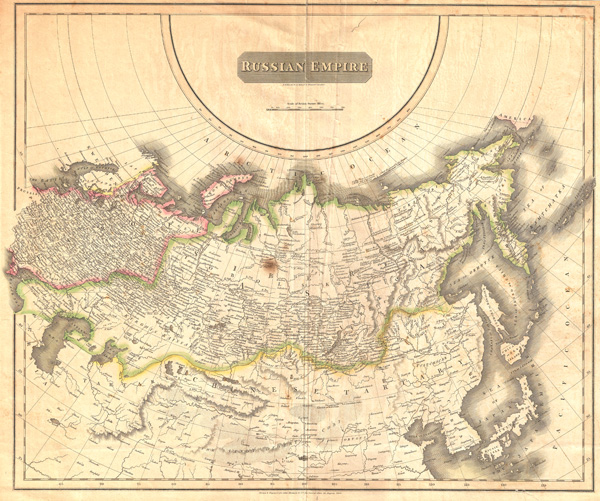
Russian Empire.
sold
- Digital Map Information
- Suitable for large format printing
- Full resolution TIFF file
- ICC color profile embedded
- Delivered instantly via download link
A large 1814 atlas map of the Russian Empire issued for Edinburgh cartographer John Thomson's New General Atlas . Covers the entirety of the Russian Empire both in Europe and in Asia as well as adjacent ... (more details)

Texas, New Mexico, and Indian Territory.
sold
- Digital Map Information
- Suitable for large format printing
- File Size: 5.78 MB
- File Type: ZIP / TIFF
- ICC color profile embedded
- Delivered instantly via download link
This richly detailed c. 1870 map of Texas, New Mexcio, and Indian Territory (later Oklahoma) is delicately shaded, with relief shown by hachures, and finely detailed. Includes inset map of 'Vicinity of ... (more details)
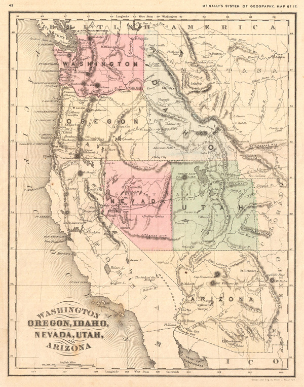
Washington, Oregon, Idaho, Nevada, Utah and Arizona.
sold
- Digital Map Information
- Suitable for large format printing
- Full resolution TIFF file
- ICC color profile embedded
- Delivered instantly via download link
This delicately shaded c. 1870 map of Washington, Oregon, Idaho, Nevada, Utah and Arizona shows relief by hachures. Drawn and engraved by Oliver Stuart of New York, the map was published as Map No. 17 ... (more details)

The World in Hemispheres with Other Projections &c. &c.
sold
- Digital Map Information
- Suitable for large format printing
- File Size: 9.5 MB
- File Type: ZIP / TIFF
- ICC color profile embedded
- Delivered instantly via download link
A beautiful example of S. A. Mitchell Jr.'s 1860 decorative double hemisphere map of the world. Upper part of the map depicts the world's great rivers in relative proximity to one another with regard ... (more details)

Plan of Baltimore.
sold
- Digital Map Information
- Suitable for large format printing
- File Size: 7.93 MB
- File Type: ZIP / TIFF
- ICC color profile embedded
- Delivered instantly via download link
A beautiful example of S. A. Mitchell Jr.'s 1872 map Baltimore, Maryland. Offers wonderful detail at the street level including references to the important buildings, trains, canals, and roads. ... (more details)

Province De Constantine.
sold
- Digital Map Information
- Suitable for large format printing
- File Size: 16.06 MB
- File Type: ZIP / TIFF
- ICC color profile embedded
- Delivered instantly via download link
Beautiful, lushly exotic illustrations of flora, fauna and people border this highly detailed, colored 1870 map of colonial Algeria, or 'Province De Constantine.' Extends from the Mediterranean ... (more details)

Antilles.
sold
- Digital Map Information
- Suitable for large format printing
- DPI: 300
- File Size: 5.17 MB
- File Type: ZIP / TIFF
- ICC color profile embedded
- Delivered instantly via download link
An attractive 1852 map of the Caribbean by A. Vuillemin. Details color coded colonial holdings, relief shown by hachures. Features a beautiful frame style border. Prepared by A. Vuillemin for ... (more details)
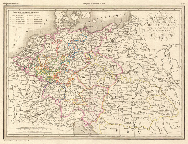
Carte De L'Allemagne Par Cercles en 1789. No. 47. Grave par Thierry.
sold
- Digital Map Information
- Suitable for large format printing
- DPI: 300
- File Size: 6.24 MB
- File Type: ZIP / TIFF
- ICC color profile embedded
- Delivered instantly via download link
Malte-Conrad's historical 1839 map of Germany and Poland as it appeared in 1789. Covers from the North Sea to the Adriatic, and east as far as Poland, Hungary, and Transylvania. States and ... (more details)