
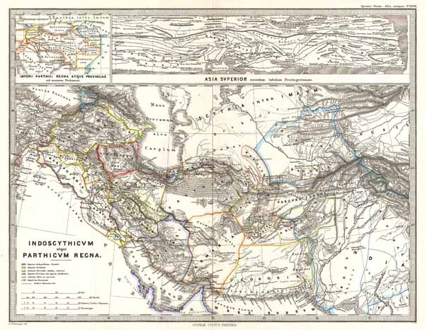
Indoscythicum atque Parthicus Recna.
sold
- Digital Map Information
- Suitable for large format printing
- File Size: 4.38 MB
- File Type: ZIP / TIFF
- ICC color profile embedded
- Delivered instantly via download link
A particularly interesting map, this is Karl von Spruner's 1865 rendering of Persia in antiquity. This map covers the from Caucuses region between the Black Sea and the Caspian Sea, southwards to include the entire Persian Gulf, and eastwards as far as western ... (more details)

Albania, Iberia, Colchis, Armenia, Mesopotamia, Babylonia, Assyria.
sold
- Digital Map Information
- Suitable for large format printing
- File Size: 2.39 MB
- File Type: ZIP / TIFF
- ICC color profile embedded
- Delivered instantly via download link
A particularly interesting map, this is Karl von Spruner's 1865 rendering of the Caucuses and Mesopotamia in antiquity. Centered on Lake Van (modern day eastern Turkey), this map covers the Caucuses region between the Black Sea and the Caspian Sea, then ... (more details)

Italiae regiones I II III IIII, Sicilia.
sold
- Digital Map Information
- Suitable for large format printing
- File Size: 4.6 MB
- File Type: ZIP / TIFF
- ICC color profile embedded
- Delivered instantly via download link
A particularly interesting map, this is Karl von Spruner's 1865 rendering of Southern Italy and Sicily in antiquity. This map covers southern Italy from Rome south as far as modern day Naples and Sicily, and east as far as Calabria. Like most of ... (more details)

Italiae Regiones IIII V VI VII VIII VIIII X XI.
sold
- Digital Map Information
- Suitable for large format printing
- File Size: 6.36 MB
- File Type: ZIP / TIFF
- ICC color profile embedded
- Delivered instantly via download link
A particularly interesting map, this is Karl von Spruner's 1865 rendering of Northern Italy and Rome in antiquity. This map covers northern Italy from modern day Venetia south as far as Rome and west to modern day Piedmont. Like most of ... (more details)

Arabia, Aethiopia, Aegyptus.
sold
- Digital Map Information
- Suitable for large format printing
- File Size: 4.14 MB
- File Type: ZIP / TIFF
- ICC color profile embedded
- Delivered instantly via download link
A particularly interesting historic map, this is Karl von Spruner's 1865 rendering of Arabia, Aethiopia (Ethiopia) and Egypt (Aegyptus) in antiquity. Centered on the Red Sea or Mare Rubrum , this map covers the entirety of the Arabian ... (more details)

Cyrenaica, Africa, Mauretania
sold
- Digital Map Information
- Suitable for large format printing
- File Size: 6.07 MB
- File Type: ZIP / TIFF
- ICC color profile embedded
- Delivered instantly via download link
This is Karl von Spruner's 1865 map of Cyrenaica, Africa, and Mauretania, collectively known as The Maghreb. Presently, the Maghreb makes up the areas of Morocco, Algeria, Tunisia, Libya, Mauritania and the disputed territory of ... (more details)

Hispania.
sold
- Digital Map Information
- Suitable for large format printing
- File Size: 7.39 MB
- File Type: ZIP / TIFF
- ICC color profile embedded
- Delivered instantly via download link
This is Karl von Spruner's 1865 map of Hispania (modern day Spain and Portugal). Under the Roman Republic, Hispania or Iberia was divided into two provinces: Hispania Citerior and Hispania Ulterior –both of which are noted ... (more details)

Pannonia, Illyricum, Dacia, Moesia, Thracia, Macedonia, Epirus.
sold
- Digital Map Information
- Suitable for large format printing
- File Size: 7.65 MB
- File Type: ZIP / TIFF
- ICC color profile embedded
- Delivered instantly via download link
This is Karl von Spruner's 1865 map of Pannonia, Illyria, Dacia, Moesia, Thrace, Macedonia, and Epirus, collectively known as 'The Balkans.' This highly detailed map shows present day Romania, Bulgaria, Macedonia, Albania, ... (more details)

Phoenice, Coelesyria, Decapolis, Iudaea, Herodiadarum tempore.
sold
- Digital Map Information
- Suitable for large format printing
- File Size: 6.14 MB
- File Type: ZIP / TIFF
- ICC color profile embedded
- Delivered instantly via download link
This is Karl von Spruner's 1865 map of the Holy Land, or Israel and Palestine. Essentially nine maps in one, Spruner features two dominant maps and 7 smaller insets, including a Peutinger Table in the lower-right quadrant. ... (more details)

Britannia et Hibernia.
sold
- Digital Map Information
- Suitable for large format printing
- File Size: 5.51 MB
- File Type: ZIP / TIFF
- ICC color profile embedded
- Delivered instantly via download link
This is Karl von Spruner's 1865 map of England, Scotland, and Ireland (Britannia et Hibernia) in antiquity. Shows names of ancient tribes and peoples and the areas they inhabited. In addition to the main map there are ... (more details)
Sunning and scarce 17th century world map in two panels.
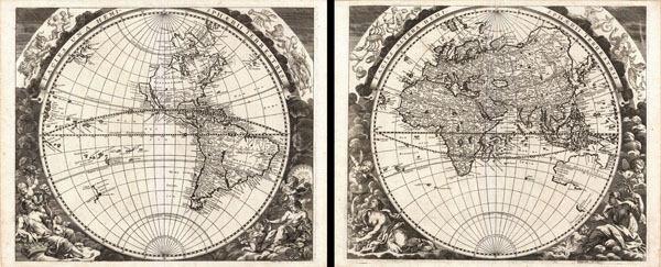
Facies una Hemi-sphaerii Terrestris. Facies Altern Hemi-sphaerii Terrestris.
sold
- Digital Map Information
- Suitable for large format printing
- DPI: 300
- File Size: 22.14 MB
- File Type: ZIP / TIFF
- ICC color profile embedded
- Delivered instantly via download link
An extremely rare discovery, this is a wonderful 1693 double hemisphere map of the world in two panels. Both of these maps were drawn and engraved by the German Enlightenment era polymath Johann Zahn for his ... (more details)
One of the finest maps of New York and New England to appear in the 19th century.
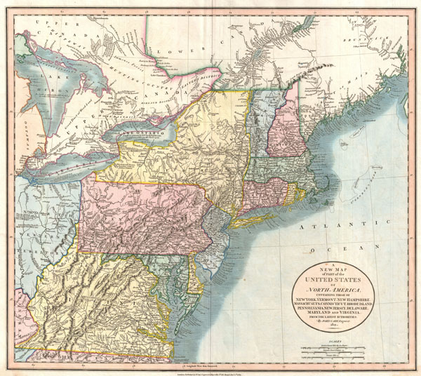
A New Map of Part of the United States of North America, Containing those of New York, Vermont, New Hampshire, Massachusets, Connecticut, Rhode Island, Pennsylvania, New Jersey, Delaware, Maryland and Virginia.
sold
- Digital Map Information
- Suitable for large format printing
- DPI: 300
- File Size: 12.83 MB
- File Type: ZIP / TIFF
- ICC color profile embedded
- Delivered instantly via download link
Published by John Cary in 1821, this is one of the most interesting atlas maps of the north-eastern parts of the United States to appear in the early 19th century. Centered on New York and Pennsylvania, ... (more details)

Map of Mexico, Central America, and the West Indies.
sold
- Digital Map Information
- Suitable for large format printing
- File Size: 13.07 MB
- File Type: ZIP / TIFF
- ICC color profile embedded
- Delivered instantly via download link
A fine example of Mitchell's 1866 map of Mexico, Central America, and the West Indies. Centered on New Orleans, this map covers all of Mexico, the West Indies, the Gulf of Mexico, the Caribbean Sea, the ... (more details)
One of the first American Maps to show Lake Victoria.
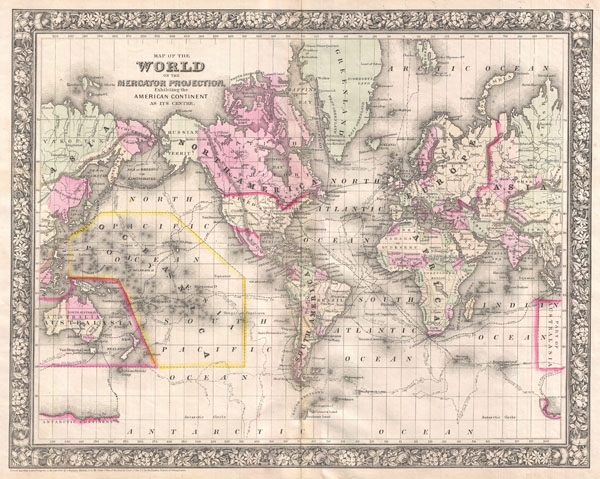
Map of the World on the Mercator Projection, Exhibiting the American Continent at its Centre.
sold
- Digital Map Information
- Suitable for large format printing
- File Size: 10.44 MB
- File Type: ZIP / TIFF
- ICC color profile embedded
- Delivered instantly via download link
A fine example of Mitchell's 1866 map of the World on Mercator's projection. This map covers the entire world with the American continent at its center. The routes of important explorers including ... (more details)
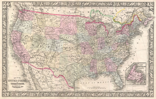
Map of the United States, and Territories, together with Canada & c.
sold
- Digital Map Information
- Suitable for large format printing
- File Size: 12.39 MB
- File Type: ZIP / TIFF
- ICC color profile embedded
- Delivered instantly via download link
A fine example of Mitchell's 1866 map of the United States. This map covers the entirety of the continental United States along with parts of Canada and Mexico. Depicts the country in considerable ... (more details)
Stunning early 19th century view of New York City.

Newyorks Hamn och Redd Fran Brooklyn pa Longisland.
sold
- Digital Map Information
- Suitable for large format printing
- DPI: 300
- File Size: 7.37 MB
- File Type: ZIP / TIFF
- ICC color profile embedded
- Delivered instantly via download link
A fine and highly desirable 1824 aquatint of New York City and harbor as seen from Brooklyn. Based on a drawing composed by the Swedish naval officer Baron Axel Leonhard Klinkowström on his 1818 ... (more details)

Gray's Atlas Map of North Carolina.
sold
- Digital Map Information
- Suitable for large format printing
- File Size: 8.62 MB
- File Type: ZIP / TIFF
- ICC color profile embedded
- Delivered instantly via download link
A very attractive 1874 map of North Carolina by O. Gray. This map covers the entire state in considerable detail with vivid hand coloring at the county level. Notes roads, railways, towns and ... (more details)

Sketch F Showing the Progress of the Survey in Section VI. With a General Reconnaissance of the Coast of Florida 1848-55.
sold
- Digital Map Information
- Suitable for large format printing
- File Size: 7.95 MB
- File Type: ZIP / TIFF
- ICC color profile embedded
- Delivered instantly via download link
A beautiful example of the U.S. Coast Survey's 1855 triangulation chart or map of the Florida Peninsula. This map covers from St. Augustine and Apalachee Bay southwards as far as Key West and ... (more details)

(F No. 6) Reconnaissance of Tampa Bay, Florida.
sold
- Digital Map Information
- Suitable for large format printing
- File Size: 8.59 MB
- File Type: ZIP / TIFF
- ICC color profile embedded
- Delivered instantly via download link
A very attractive example of the 1855 U.S. Coast Survey nautical chart or map of Tampa Bay, Florida. Centered on Passage Point, this map covers from St. Helena and Tampa south to Mullet Key ... (more details)

(E No. 6) Preliminary Chart of Savannah River Georgia.
sold
- Digital Map Information
- Suitable for large format printing
- File Size: 13.17 MB
- File Type: ZIP / TIFF
- ICC color profile embedded
- Delivered instantly via download link
This is a very attractive example of the 1855 U.S. Coast Survey nautical chart or map of the Savannah River, Georgia. Centered on Jones Island, this map extends from the river's mouth at ... (more details)