

Hempstead Harbor Long Island.
sold
- Digital Map Information
- Suitable for large format printing
- File Size: 5.9 MB
- File Type: ZIP / TIFF
- ICC color profile embedded
- Delivered instantly via download link
This is a very nice example of the 1859 U.S. Coast Survey nautical chart or map of Hempstead Harbor, Long Island. Focusing on the harbor, as titled, this map covers from Prospect Point to Redspring Point and as far south as Harbor Beach and East Beach, includes ... (more details)

Harbor of Refuge No. The Harbor of Holmes' Hole.
sold
- Digital Map Information
- Suitable for large format printing
- DPI: 300
- File Size: 5.22 MB
- File Type: ZIP / TIFF
- ICC color profile embedded
- Delivered instantly via download link
This is a rare example of the 1847 U.S. Coast Survey nautical chart or map of Holmes' Hole (Vineyard Haven), Martha's Vineyard, Massachusetts. Focusing on the town of Holmes' Hole, today's Vineyard Haven, this map covers from West Chop to East Chop and as far ... (more details)

(C No. 2) Preliminary Chart of Part of the Sea Coast of Virginia and Entrance to the Chesapeake Bay.
sold
- Digital Map Information
- Suitable for large format printing
- File Size: 12.06 MB
- File Type: ZIP / TIFF
- ICC color profile embedded
- Delivered instantly via download link
An uncommon nautical chart or map of the entrance to the Chesapeake Bay issued in 1855 by the U.S. Coast Survey. This map covers from Norfolk, Virginia to Gargathy Inlet. The chart features countless depths soundings as well as detailed sailing instructions ... (more details)

Sketch C Showing the Progress of the Survey in Section No. III from 1843 to 1859.
sold
- Digital Map Information
- Suitable for large format printing
- File Size: 17.71 MB
- File Type: ZIP / TIFF
- ICC color profile embedded
- Delivered instantly via download link
This is an exceptional example of the 1859 U.S. Coast Survey's progress chart of the Chesapeake Bay. The map covers from the mouth of the Susquehanna River southwards as far as Cape Henry and Norfolk. This chart includes both the Chesapeake Bay and ... (more details)
One of the U.S. Coast Survey's most decorative maps.

(J No. 7) Reconnaissance of the Western Coast of the United States (Northern Sheet) from Umpquah River to the Boundary.
sold
- Digital Map Information
- Suitable for large format printing
- File Size: 16.78 MB
- File Type: ZIP / TIFF
- ICC color profile embedded
- Delivered instantly via download link
One of the U.S. Coast Survey's most attractive productions, this is a rare hand colored 1855 chart of the coastline of the Pacific Northwest, including the modern day states of Washington and Oregon. The map extends from the Oregon-California border ... (more details)
Important Tokugawa Era Japanese Map of the World labeling the Sea of Joseon.
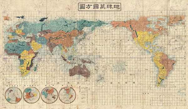
Shintei - Chikyu Bankoku Hozu (Square Map of all the Countries on the Globe)
sold
- Digital Map Information
- Suitable for large format printing
- DPI: 300
- File Size: 58.45 MB
- File Type: ZIP / TIFF
- ICC color profile embedded
- Delivered instantly via download link
A very interesting 1853 (Kaei 6) Japanese world map by Suido Nakajima. Presented on a Mercator projection, this map marks a significant advancement in Japanese globular cartography and a far more sophisticated adaptation of western cartographic ... (more details)
Magnificent two panel wall map. One of the finest maps of Asia to appear in the early 19th century.
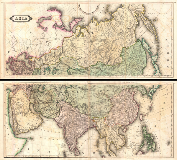
Asia.
sold
- Digital Map Information
- Suitable for large format printing
- DPI: 300
- File Size: 135.07 MB
- File Type: ZIP / TIFF
- ICC color profile embedded
- Delivered instantly via download link
An extremely appealing large format c. 1820 map of Asia rendered in two panels. Truly one of the most beautiful large format maps of Asia to appear in an early 19th century atlas. Drawn by Daniel Lizars this map covers from the Mediterranean to ... (more details)
Art deco plan of San Francisco.
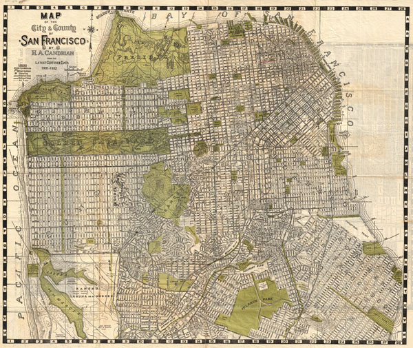
Map of the City & County of San Francisco.
sold
- Digital Map Information
- Suitable for large format printing
- File Size: 28.19 MB
- File Type: ZIP / TIFF
- ICC color profile embedded
- Delivered instantly via download link
An appealing 1932 art deco style pocket map of San Francisco, California, by H. A. Candrian. Issued just prior to World War II this map covers the city from Presidio Park as far south as McLaren Park and the Laguna de la Merced. The map names ... (more details)
Pristine 18th century case or pocket map of Paris, France.

Nouveau Plan Routier de la Ville et Faubourgs de Paris.
sold
- Digital Map Information
- Suitable for large format printing
- DPI: 300
- File Size: 109.23 MB
- File Type: ZIP / TIFF
- ICC color profile embedded
- Delivered instantly via download link
An extraordinary map of pre-Haussmann pre-Revolutionary Paris and the early Faubourgs (suburbs) issued in 1780, during the final decade of the French Monarchy. Covers Paris on Both sides of the Seine from the Ecole Militaire to the Hospital de ... (more details)

Imperium Romanorum inde a Constantini Magni tempore.
sold
- Digital Map Information
- Suitable for large format printing
- File Size: 6.85 MB
- File Type: ZIP / TIFF
- ICC color profile embedded
- Delivered instantly via download link
This is Karl von Spruner's 1865 map of the Roman Empire under the emperor Constantine. This detailed covers the entirety of Europe but focuses the Roman lands in modern day England, France, Spain, Greece, Italy, Turkey, and north Africa. An ... (more details)
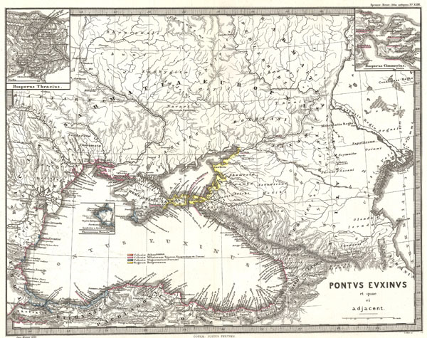
Pontus Euxinus et quae ei adjacent.
sold
- Digital Map Information
- Suitable for large format printing
- File Size: 18.9 MB
- File Type: ZIP / TIFF
- ICC color profile embedded
- Delivered instantly via download link
This is Karl von Spruner's 1865 map of the Black Sea and adjacent regions (Pontus Euxinus et quae ei Adjacent). This detailed map focuses on the Black Sea and the area immediately surrounding it, including what is modern day Ukraine, the ... (more details)

Mare internum cum populis adiacentibus a bello Hannibalico usque ad Mithridatis Magni tempus
sold
- Digital Map Information
- Suitable for large format printing
- File Size: 8.07 MB
- File Type: ZIP / TIFF
- ICC color profile embedded
- Delivered instantly via download link
This is Karl von Spruner's 1865 map, The Mediterranean with Adjacent Peoples from Hannibal's War to the Time of Mithridates the Great. Showing the modern day countries of Spain, France, Italy, Switzerland, Greece, the Balkans, Turkey, ... (more details)

Italia, Gallia citerior, Illyricum, Sicilia, Sardinia, Corsica, quales post leges Plautiam Papiriam at Pompeiam usque ad bellum Actiacum fuerunt
sold
- Digital Map Information
- Suitable for large format printing
- File Size: 20.33 MB
- File Type: ZIP / TIFF
- ICC color profile embedded
- Delivered instantly via download link
This is Karl von Spruner's 1865 map of Italy, nearer Gaul, Illyria, Sicily, Sardinia, Corsica after the Battle of Actium. This detailed map shows the whole of Italy, Sicily, Corsica, and Sardinia. Spruner also includes three detailed ... (more details)

Italia, Gallia cisalpina, Sicilia, Sardinia, Corsica, ab adventu Gallorum usque ad bellum Marsicum
sold
- Digital Map Information
- Suitable for large format printing
- File Size: 7.49 MB
- File Type: ZIP / TIFF
- ICC color profile embedded
- Delivered instantly via download link
This is Karl von Spruner's 1865 map of Italy, Cisalpine Gaul, Sicily, Sardinia, Corsica, to the arrival of the Gauls after the Marsicus War. This is essentially two larger maps in one, with four smaller insets. In the left quadrant ... (more details)

Italia adiectis iis, in quas usque ad Augusti tempus Italiae nomen propagatum est, regionibus, Sicilia, Sardinia, Corsica quales fuerunt ante adventum Gallorum.
sold
- Digital Map Information
- Suitable for large format printing
- File Size: 7.57 MB
- File Type: ZIP / TIFF
- ICC color profile embedded
- Delivered instantly via download link
This is Karl von Spruner's 1865 map of Italy, Sicilia, Sardinia and Corsica under Augustus Caesar, at the start of the Roman Empire. Spruner depicts the entire country of Italy as a whole, with a detailed inset of Etruia, a region ... (more details)

Orbis Terrarum post proelium Corupdiense
sold
- Digital Map Information
- Suitable for large format printing
- File Size: 7.28 MB
- File Type: ZIP / TIFF
- ICC color profile embedded
- Delivered instantly via download link
This is Karl von Spruner's 1865 map, Orbis Terrarum post proelium Corupediense, or The World after the Battle of Corupedium. The Battle of Corupedium (also called Corupedion) is the name of the last battle of the Diadochi, the ... (more details)

Graecia, Epirus post bella Persica
sold
- Digital Map Information
- Suitable for large format printing
- File Size: 7.57 MB
- File Type: ZIP / TIFF
- ICC color profile embedded
- Delivered instantly via download link
This Karl von Spruner's 1865 map of Graecia, Epirus post Bella Persica, or Greece, Epirus after the Persian War. This beautiful map is outlined in color and covers the entire area of modern day Greece. The map also features ... (more details)

Graecia, Macedonia, Thracia etc. inde a belli Peloponnesiaci tempore.
sold
- Digital Map Information
- Suitable for large format printing
- File Size: 6.98 MB
- File Type: ZIP / TIFF
- ICC color profile embedded
- Delivered instantly via download link
This is Karl von Spruner's 1865 map of Graecia, Macedonia, Thracia. Showing the whole of Greece, Macedonia, and Thracia (modern day Southeast Bulgaria, Northeast Greece, and European Turkey) the map also includes 6 smaller ... (more details)

Graecia Tempore Migrationis Doricae
sold
- Digital Map Information
- Suitable for large format printing
- File Size: 8.8 MB
- File Type: ZIP / TIFF
- ICC color profile embedded
- Delivered instantly via download link
This is Karl von Spruner's 1865 map of Graecia Tempore Migrationis Doricae, or Greece at the time Doric Migration. Map covers modern day Macedonia, Bulgaria, Greece, Albania, Turkey, Cyprus, and Crete. The map also ... (more details)

Canaan.
sold
- Digital Map Information
- Suitable for large format printing
- File Size: 6.52 MB
- File Type: ZIP / TIFF
- ICC color profile embedded
- Delivered instantly via download link
This is Karl von Spruner's 1865 map of Canaan, Israel, Palestine, or the Holy Land in antiquity. This detailed map focuses on the eastern Mediterranean coastline from Gaza to Sarepta and inland as far as the Dead ... (more details)