Authenticity Guaranteed — We sell only original antique maps.
Geographicus Rare Antique Maps
Authenticity Guaranteed — We sell only original antique maps.
Navigation
Shopping Cart
Sort By Price: highest first

Spencer D. Hunt

A storyteller at heart, focused on 19th- and 20th-century conflict — with an eye for pictorial and allegorical maps.


I came to Geographicus through my passion for history. I believe in knowing our collective past and the surprising nuances that come with it — because in the end, history isn't about names and dates, it's about stories. Many of the stories I've found through Geographicus I'd never have encountered otherwise, and sharing them with clients is my favorite part of the work.

That passion started with an interest in WWII aircraft, which grew into a broader focus on 19th- and 20th-century conflict — the lens I bring to my work here. I'm also drawn to pictorial and allegorical maps, and editorial cartoons.

Monthly Digest of Spencer's Picks

Portrait of Spencer D. Hunt
Sort by
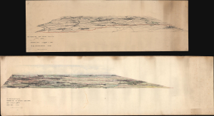
Only Known Surviving Examples of WWI 'balloonatic' Views.

Panoramic View. La Bassee (Canal) to Loos. No 30. Balloon Section. 21:2:1917. / Panoramic View from Q 24a0.0: Lens to Vimy.

1917 (dated)
8.5 x 32.25 in (21.59 x 81.92 cm)
WWIBalloonViews-unknown-1917

sold

A Closer Look
  • Digital Map Information
  • Suitable for large format printing
  • Full resolution TIFF file
  • ICC color profile embedded
  • Delivered instantly via download link
An extraordinary survival, this is a pair of manuscript panoramic views of part of the Western Front in northeastern France during World War I (1914 - 1918). These views were drawn by members of the Royal Naval Air Service and the Royal Flying Corps who rode in baskets beneath hydrogen-filled balloons thousands of feet above the front lines to observe enemy movements and direct artillery fire. Known as kite balloons, these were legitimate military targets, earning the 'balloonatics' had a very high mortality rate. (more details)
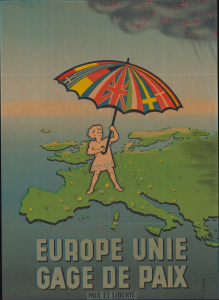
Shelter from the communist storm.

Europe Unie Gage de Paix. [Europe United Guarantee of Peace.]

1951 (undated)
30 x 21.75 in (76.20 x 55.24 cm)
GagedePaix-morac-1951

sold

A Closer Look
  • Digital Map Information
  • Suitable for large format printing
  • Full resolution TIFF file
  • ICC color profile embedded
  • Delivered instantly via download link
This is a c. 1951 Paix et Liberté propaganda broadside map of Europe presaging European unification. The map reflects both optimism and threat in the post-World War II (1939 - 1945) Era. Western Europe enjoyed a post-war flowering of cross-national solidarity, as well as industrial, cultural, and trade booms. Eastern Europe, at the same time, languished under Communism. (more details)
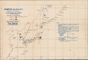
Planning to Win the Peace.

CAMPUS (BLACKLIST) Appendix I to Annex C Allocation of Areas of Responsibility.

1945 (dated)
12 x 18.5 in (30.48 x 46.99 cm)
CampusAllocationAreas-cincpoa-1945

sold

A Closer Look
  • Digital Map Information
  • Suitable for large format printing
  • Full resolution TIFF file
  • ICC color profile embedded
  • Delivered instantly via download link
This is the official CINCPOA Operation CAMPUS plan for the occupation of Japan, issued on August 12, 1945, 3 days after the second atomic bomb was dropped on Nagasaki (August 9), Japan, and 3 days before the Japanese surrender (August 15). This map shows cities prioritized for occupation and provides a summary of how the occupation zones were to be divided. (more details)
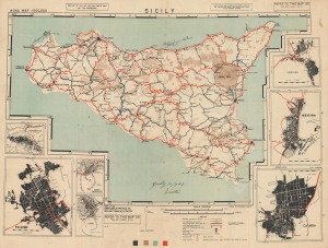
Manuscript notations follow the 3rd Infantry Division across Sicily from Licata to Messina.

Road Map 1 : 500000 Sicily.

1943 (dated)
22 x 28.75 in (55.88 x 73.02 cm)
Sicily-afhq-1943-2

sold

A Closer Look
  • Digital Map Information
  • Suitable for large format printing
  • Full resolution TIFF file
  • ICC color profile embedded
  • Delivered instantly via download link
An exceptional World War II battlefield artifact, this is a 1943 Allied Force Headquarters road map of Sicily, issued in preparation for Operation Husky, the Allied invasion of the island. Manuscript annotations trace the advance of the U.S. Army's 3rd Infantry Division from its July 10 landing at Licata through the capture of Palermo and the final drive toward Messina, transforming a restricted military planning map into a firsthand record of the Sicilian Campaign. (more details)
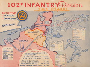
102nd Infantry Division during World War II.

102d Infantry Division. The Ozarks.

1945 (undated)
11.75 x 15.625 in (29.84 x 39.69 cm)
102ndInfDiv-unknown-1945

sold

A Closer Look
  • Digital Map Information
  • Suitable for large format printing
  • Full resolution TIFF file
  • ICC color profile embedded
  • Delivered instantly via download link
This is a c. 1945 World War II pictorial campaign map tracing the U.S. Army's 102nd Infantry Division across Europe. Produced for members of the division before their return to the United States, it combines a detailed record of troop movements, battles, river crossings, and captured towns with lively illustrations of aerial combat and European landmarks. (more details)
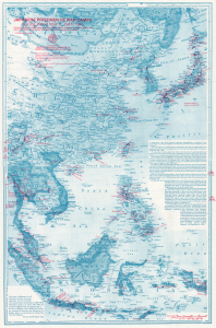
Japanese WWII POW camps.

Japanese Prisoner of War Camps During World War II, 1941 - 1945. Known locations of camps where American, British, Dutch, Australian, Canadian, Indian, and other Allied Military and Civilian Personnel were imprisoned by the Japanese.

1980 (dated)
31.25 x 20.25 in (79.38 x 51.44 cm)
JapanesePOWCamps-lipe-1980-2

sold

A Closer Look
This is a 1980 Frances Worthington Lipe map of East Asia highlighting World War II (1939 - 1945) Japanese prisoner-of-war camps. Lipe dedicates her research and this map to her father, Josiah Wistar Worthington, who survived 2.5 years in several such camps. (more details)
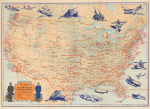
Military Bases in the United States during World War II.

Rand McNally Map of United States Military Posts.

1944 (dated)
18.25 x 26 in (46.36 x 66.04 cm)
MilitaryPosts-randmcnally-1944-2

sold

A Closer Look
  • Digital Map Information
  • Suitable for large format printing
  • Full resolution TIFF file
  • ICC color profile embedded
  • Delivered instantly via download link
This 1944 Rand McNally map of the United States labels all the military installations in the continental United States. It captures part of the complete mobilization of American society to fight a global war. (more details)
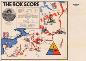
Follow the 7th Armored Division as it marches across Europe.

The Box Score.

1945 (undated)
22.5 x 33 in (57.15 x 83.82 cm)
TheBoxScore-lerman-1945-2

sold

A Closer Look
  • Digital Map Information
  • Suitable for large format printing
  • Full resolution TIFF file
  • ICC color profile embedded
  • Delivered instantly via download link
This is a 1945 Lerman World War II pictorial route map of the 7th Armored Division in Europe. Illustrations, information, and geography combine to create a stunning visual summary of the 7th Armored's march across the continent. (more details)
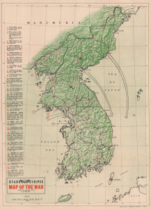
Height of the Korean War.

Map of the War.

1952 (dated)
20.5 x 14.75 in (52.07 x 37.46 cm)
Korea-pacific-1952-3

sold

A Closer Look
  • Digital Map Information
  • Suitable for large format printing
  • Full resolution TIFF file
  • ICC color profile embedded
  • Delivered instantly via download link
This is a 1952 Pacific Stars and Stripes map of the Korean War. It traces events from the North Korean invasion of South Korea on June 25, 1950, through Operation Strangle, a sustained attack on North Korean communication and supply lines in late August 1951. (more details)

Stay Informed

First Look at New Acquisitions

New inventory updates delivered directly to your inbox.