
Army Orientation Branch (sold)

The Army Orientation Branch (1940 - c. 1949) created special maps for teaching the Army Orientation Course and was based at The Pentagon in Washington, D.C. The Army Orientation Branch was part of the Information and Education Division.
Emphasizes the continuing struggle for Guadalcanal and Stalingrad.
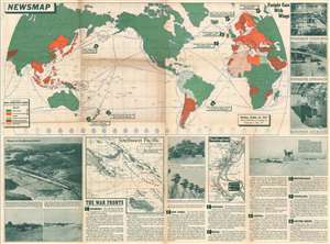
Newsmap. Monday, October 26, 1942 Week of October 16 to October 23. Volume 1, No. 27.
sold
- Digital Map Information
- Suitable for large format printing
- File Size: 94.63 MB
- File Type: ZIP / TIFF
- ICC color profile embedded
- Delivered instantly via download link
This is a 1942 Army Orientation Course newsmap of the wold. Using colors, the territory of the 'United Nations' and Axis and Axis occupied territory are differentiated on the map occupying the upper half of the sheet, as are the sympathies of the rest of the world's nations. Eight numbered arrows point out important events in the war that took place all over the world, with circles emphasizing exactly where each action occurred. This week the Army Orientation Course chose to emphasize the continuing fight on Guadalcanal and New Guinea, as well as combat in the Aleutians, the siege at Stalingrad, and the blockade of Malta. (more details)
A large map of North Africa meant for U.S. servicemen to use for tracking the North African campaign.
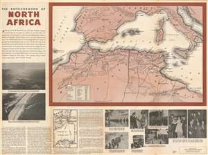
The Battleground of North Africa.
sold
- Digital Map Information
- Suitable for large format printing
- File Size: 118.38 MB
- File Type: ZIP / TIFF
- ICC color profile embedded
- Delivered instantly via download link
Published a month after the Operation Torch landings in Morocco and Algeria, this 1942 Army Orientation Branch Newsmap of North Africa was distributed so Allied troops could follow the progress of the new campaign. Depicting the region from Madeira Island to Libya, the focus is placed on the area where American soldiers were fighting the Wehrmacht for the first time, likely because American soldiers were the main audience for which Newsmaps were produced. Cities and towns are identified, including the key strategic locations of Casablanca, Algiers, Oran, Bizerte, Tunis, Sfax, and Sousse. Roads and railroads are also illustrated. A table in the lower left corner of the map informs the viewer of the distances involved in getting to North Africa, with the 3,486 miles between New York and Gibraltar at the top. (more details)
A new perspective on the Pacific Theater.
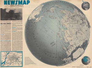
NEWSMAP. Monday, November 29, 1943. Week of November 18 to November 25. 220th Week of the War - 102nd Week of U.S. Participation.
sold
- Digital Map Information
- Suitable for large format printing
- Full resolution TIFF file
- ICC color profile embedded
- Delivered instantly via download link
Attempting to help viewers gain a new perspective on distances involved in fighting the Pacific front, this is a 1943 Army Orientation Branch Newsmap map of the Pacific Ocean and Asia. Using a map created by Richard Edes Harrison, this Newsmap places Japan at the center of a globe. (more details)
The care and feeding of your battleship and its crew.
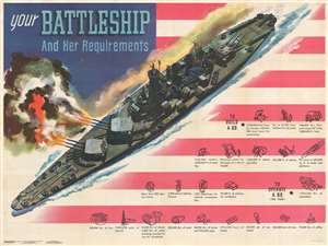
Your Battleship And Her Requirements. / NEWSMAP for the Armed Forces. Monday, May 22, 1944. 245th Week of the war - 127th Week of U.S. Participation.
sold
- Digital Map Information
- Suitable for large format printing
- Full resolution TIFF file
- ICC color profile embedded
- Delivered instantly via download link
This is a 1944 Army Orientation Branch newsmap propaganda broadside of a North Carolina class battleship. The battleship steams across an American flag and fires a salvo from its two forward gun batteries. Smaller gun batteries flank the ship's superstructure, and smaller anti-aircraft batteries dot the rest of the ship's deck, from bow to stern. Infographics concerning the construction and operation of a 'BB' (U.S. Navy abbreviation for battleships) appear in the right quadrant, over the stripes of the flag. Nearly the first three rows detail parts of a battleship's construction (which took a force of 6,250 shipbuilders 3.5 years to finish) and required 1,135,000 rivets; 1,220,000 feet of electrical cable; 422,000 feet of piping; 5,300 electric light fixtures; and 1,091 telephones. Operational statistics, given per year, include: 9,000,000 gallons of fuel oil; 60,000 pounds of butter; 300,000 candy bars; 100,000 bars of soap; and 75,000 pounds of coffee. (more details)
The long, brutal war for China.
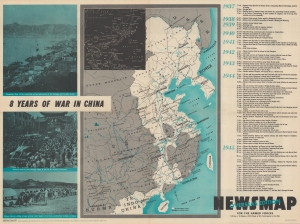
Newsmap for the Armed Forces, Overseas Edition : V-E Day + 10 weeks : 187th week of U.S. participation in the war. 8 Years of War in China.
sold
- Digital Map Information
- Suitable for large format printing
- Full resolution TIFF file
- ICC color profile embedded
- Delivered instantly via download link
A 1945 Army Information Branch Newsmap from the last stages of World War II, covering the week of July 3 to 10 and focusing on China. As indicated in the title, China had been engaged in a full-scale war with Japan for eight years by this point, more than double the time the U.S. had been in the war. (more details)
The last days of WWII - only Japan remains.
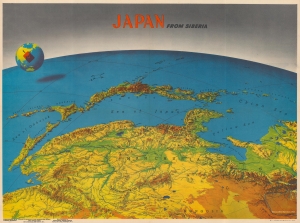
Japan from Siberia. / Newsmap Overseas Edition. For the Armed Forces. 295th Week of the War 177th Week of U.S. participation. Monday, 14 May, 1945. Week of 24 April to 1 May. Volume IV No. 3F.
sold
- Digital Map Information
- Suitable for large format printing
- Full resolution TIFF file
- ICC color profile embedded
- Delivered instantly via download link
This is a 1945 Army Orientation Branch Newsmap map of Japan in the scarce Overseas Edition. Published on Monday, May 14, 1945, this piece was distributed after Germany surrendered and the war in Europe had ended. The Army Orientation Branch utilizes the work of celebrated cartographer Richard Edes Harrison to highlight Japan, the only remaining Axis power, on the recto. On the verso, the historic linkup between the American Army and the Soviet Red Army is celebrated. (more details)
The planned but never launched amphibious invasion of the Japanese Home Islands - Operation Downfall.
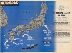
Newsmap Middle Pacific. The Planned Assault on Japan. Monday 15 October, 1945. Week of 2 October to 9 October. Volume IV No. 26F.
sold
- Digital Map Information
- Suitable for large format printing
- Full resolution TIFF file
- ICC color profile embedded
- Delivered instantly via download link
This is a rare Overseas Edition Newsmap published in October 1945 (1 month after the Japanese surrender) illustrating the planned amphibious invasions of the Japanese home islands. (more details)