
Duval, Peter Stephen (sold) (Duval's Lithographic Establishment, Duval's Establishment, P.S. Duval and Son, Lehman and Duval)
Peter Stephen Duval (1804 - February 8, 1886) was a prominent French-American Philadelphia lithographer. He immigrated to Philadelphia from France in 1831 to take a job as a lithographer at the Philadelphia firm of Cephas Childs (Childs and Inman), one of Philadelphia's first commercial lithographing firms. In 1834, Childs retired and Duval took over the business with the artist George Lehman, operating as Lehman and Duval. Duval bought out Lehman in 1837 and from that point forward operated as P. S. Duval's Lithographic Establishment, or just Duval's Establishment. In the 1840s, he became one of the first firms to introduce steam powered lithographic presses. In 1841 he became a naturalized U.S citizen. At one point he had over 30 pressers and employed one 70 artists and was one Philadelphia's largest lithographic printer. Over the course of the next 30 years, Duval would have several business partners including the Swiss-American engravers Charles and Frederick Bourquin (1808 - 1897). In 1857 his son Steven C. Duval joined the business. Peter Duval retired in 1869 but continued to be involved in his company until his death from an enlarged heart in 1886. Duval was a member of the local branches of the Freemasons and the Order of Odd Fellows in addition to being president of the Philadelphia's Lithographers' Association.
AKA: Duval's Lithographic Establishment, Duval's Establishment, P.S. Duval and Son, Lehman and Duval
An early American map of the California coastline that predates the California Gold Rush.
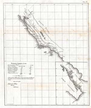
[Untitled]. June 19, 1847 Adjutant's Office, Monterey, California.
sold
- Digital Map Information
- Suitable for large format printing
- DPI: 300
- File Size: 3.24 MB
- File Type: ZIP / TIFF
- ICC color profile embedded
- Delivered instantly via download link
This is an 1847 map of the California coastline from Sonoma to San Diego. Though sparsely illustrated, each of the major army forts along the coast are labeled, including Santa Clara, Monterey, San Luis Obispo, Santa Barbara, Angeles (Los Angeles), and San Diego. The route to travel between these forts is illustrated by a dotted line. A table in the lower left corner gives the distances between these forts and the number of men stationed at each one and also notes that the Mormon Battalion is not included in the numbers of men stationed at the forts because their term of enlistment 'expires in July'. An inset map of Lower (Baja) California is situated in the lower right corner and illustrates the peninsula from north of Loreto to La Paz, where the U.S. Army maintained a fort defended by 111 soldiers. (more details)
Took place in the modern-day cities Whittier, Pico Rivera, and Montebello, CA about ten miles south of downtown Los Angeles.
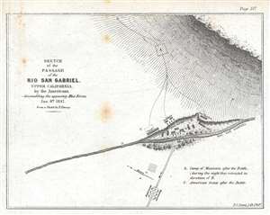
Sketch of the Passage of the Rio San Gabriel, Upper California, by the Americans, - discomfiting the opposing Mex. Forces, Jan. 8th 1847.
sold
- Digital Map Information
- Suitable for large format printing
- DPI: 300
- File Size: 1.21 MB
- File Type: ZIP / TIFF
- ICC color profile embedded
- Delivered instantly via download link
This is an 1847 William Hemsley Emory map of the Battle of Rio San Gabriel during the Mexican-American War, which took place in parts of modern-day Whittier, Pico Rivera, and Montebello, California, about ten miles south of downtown Los Angeles. The Rio San Gabriel (San Gabriel River) bisects the map and was the focus of this engagement between the American force led by Commodore Robert Stockton and the Californian contingent under the command of José María Flores. The American force had set out from San Diego on December 29th, with the goal of reaching a besieged American force in Los Angeles. On January 8th, at two-thirty in the afternoon after marching eleven- and one-half miles, Stockton and his men reached the Rio San Gabriel. As the American approached the river, they formed into a square, believing this to be the most effective defense against a mounted enemy. An advance group from the Californian force began harassing them even trying (unsuccessfully) to drive a group of wild mares into the Americans. The Mexican artillery occupied the high ground on the far side of the river, which did not provide the best fire for the Mexicans, even though they held the high ground. The Americans successfully forded the river and brought their own artillery to bear against the Mexicans, who, faced with superior firepower, withdrew to the north, closer to Los Angeles. (more details)
Illustrates the capture of Mexico City by the U.S. Army and Marines during the Mexican-American War.
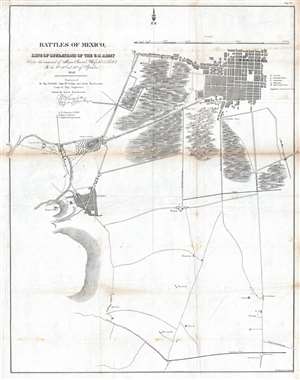
Battles of Mexico, Line of Operations of the U.S. Army under the command of Major General Winfield Scott, on the 8th, 12th and 13th of September, 1847.
sold
- Digital Map Information
- Suitable for large format printing
- DPI: 300
- File Size: 9.71 MB
- File Type: ZIP / TIFF
- ICC color profile embedded
- Delivered instantly via download link
This is an 1847 Edmund Hardcastle map of the engagements that make up the Battle of Mexico City during the Mexican-American War. The map depicts the region from the Casa de Mata near the Molino del Rey to several sites of Mexican gun batteries to the east of the San Antonio Gate and from Mexico City itself to Churubusco. Led by General Winfield Scott, American forces executed an amphibious landing and captured the port of Veracruz. The army then marched across Mexico, winning victories at the Battle of Cerro Gordo and the Battle of Churubusco, which was located only five miles outside Mexico City. Numerous artillery batteries, both American and Mexican, are identified alphabetically and correspond to information provided in the key. The citadel, national palace, cathedral, and Alameda (Alameda Central) are also identified. (more details)
Illustrates the area southwest of Mexico City which is now the upscale neighborhood of Jardines del Pedregal.
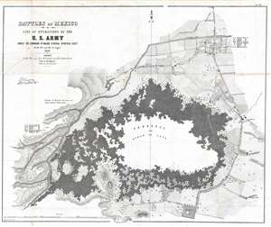
Battles of Mexico, Line of Operations of the U.S. Army under the command of Major General Winfield Scott, on the 19th and 20th of August 1847.
sold
- Digital Map Information
- Suitable for large format printing
- DPI: 300
- File Size: 16.18 MB
- File Type: ZIP / TIFF
- ICC color profile embedded
- Delivered instantly via download link
This is an 1847 Edmund Hardcastle map of the Battle of Churubusco during the Mexican-American War. The map depicts a region southwest of Mexico City surrounding the lava fields of the Pedregal de San Àngel, today the fashionable upscale residential neighborhood of Jardines del Pedgregal. Several buildings and communities are illustrated around the Pedregal, including San Augustin, San Angel, San Antonio La Isla (San Antonio), and Churubusco. Individual buildings are depicted along many of the roads, though most are not labeled. (more details)
Provides geographical context for the recently concluded Mexican-American War after the American capture of Mexico City.
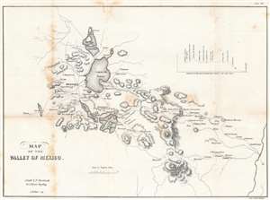
Map of the Valley of Mexico.
sold
- Digital Map Information
- Suitable for large format printing
- DPI: 600
- File Size: 10.47 MB
- File Type: ZIP / TIFF
- ICC color profile embedded
- Delivered instantly via download link
Created just after the Mexican American War, this is an 1847 Edmund Hardcastle map of the Valley of Mexico, a highlands plateau in central Mexico containing present-day Mexico City and the eastern half of the State of Mexico. The map depicts the region from Toluca to Cuatlacingo and from Xaltocan to Popocatepetl. Meant to illustrate a portion of the theater of war, Mexico City is situated on the left side near Lake Texcoco (Laguna de Tezcuco), and settlements, roads, lakes, and mountains throughout the region are illustrated. The American army, und General Winfield Scott, landed a Veracruz on the Mexican coast of the Gulf of Mexico and marched west, and eventually assaulted and captured Mexico City. A profile of their march is situated in the upper right quadrant. (more details)
Selling Polk's vision.
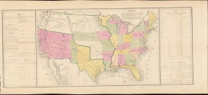
[United States.]
sold
- Digital Map Information
- Suitable for large format printing
- DPI: 600
- File Size: 699.27 MB
- File Type: ZIP / TIFF
- ICC color profile embedded
- Delivered instantly via download link
A most intriguing 1848 Ephraim Gilman map of the United States issued shortly after the Mexican-American War (1846 - 1848) to advance President James K. Polk's political agenda in his final address to Congress. A remarkable example of carto-advocacy, the map was drawn to address the territorial gains after the war, but is strongly colored by national debates over slavery in the territories. (more details)
A view of San Francisco during the California Gold Rush.
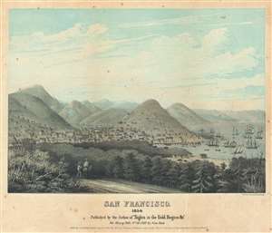
San Francisco. 1850.
sold
- Digital Map Information
- Suitable for large format printing
- DPI: 600
- File Size: 11.02 MB
- File Type: ZIP / TIFF
- ICC color profile embedded
- Delivered instantly via download link
This is an 1850 Theodore Taylor Johnson view of San Francisco during the California Gold Rush. Conveying at once the city's frontier reality and its burgeoning populace, the number of buildings and ships at anchor in the bay make it obvious that the city's ... (more details)
Important and rare early survey of Texas for the Southern Pacific Railroad.
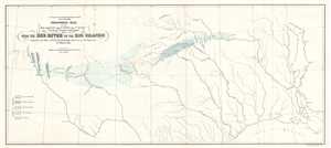
Geological map of the route explored by Capt. Jno. Pope, Corps of Topl. Engrs. near the 32nd parallel of north latitude, 1854.
sold
- Digital Map Information
- Suitable for large format printing
- DPI: 300
- File Size: 2.69 MB
- File Type: ZIP / TIFF
- ICC color profile embedded
- Delivered instantly via download link
This is an 1854 William Phipps Blake geological railroad survey map of Texas from the Red River to the Rio Grande River. The map depicts from the Rio Grande River and El Paso to the Mississippi River and Baton Rouge and from the Red River and its ... (more details)
One of the earliest Federal surveys of the Utah Territory.
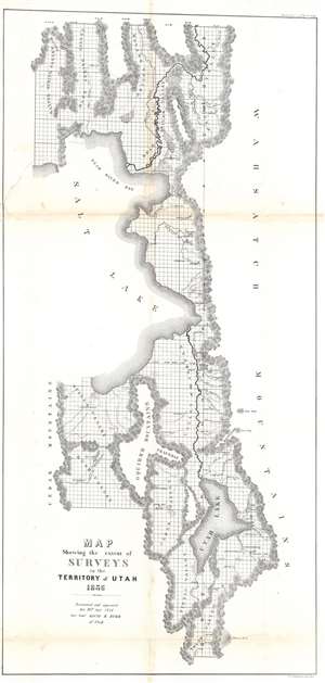
Map Showing the extent of Surveys in the Territory of Utah.
sold
- Digital Map Information
- Suitable for large format printing
- File Size: 21.79 MB
- File Type: ZIP / TIFF
- ICC color profile embedded
- Delivered instantly via download link
An important early map of Utah, this 1856 David Burr map highlights the eastern part of the Great Salt Lake and the vicinity. The map depicts the region from Hansel Spring Valley and the Cedar Mountains to the Wahsatch Mountains and from Malade Valley to Youab Valley. Mountain ranges, lakes, and smaller chains of hulls separate valleys throughout the region. These mountain ranges form the natural parries to the surveys accomplished by David Burr, then the Surveyor General of Utah, and his predecessors. These natural obstacles are the only areas not shown as having been surveyed, noted by the grid of the Public Land Survey System then in use in the United States. Cities, towns, and villages are identified as well, including Salt Lake City, Ogden, and Provo. (more details)