
Inselin, Charles (sold)

Charles Inselin (fl. c. 1700 - 1730) was a prominent French engraver active in Paris during the late 17th and early 18th centuries. Inselin engraved for prominent cartographers ranging from Nicholas Sanson to Eusebio Kino and Nicholas De Fer. He was also a minor publisher of maps and engravings on his own account. Little else is known of his life.
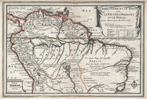
La Terre Ferme et le Perou avec le Pays des Amazones et le Bresil dans l'Amerique Meridionale.
sold
- Digital Map Information
- Suitable for large format printing
- Full resolution TIFF file
- ICC color profile embedded
- Delivered instantly via download link
This is a scarce and beautiful example of Nicholas De Fer's 1702 map of northern South America. It covers from Panama to Rio de Janeiro and renders the entire region in extraordinary detail offering both topographical and political information with mountains ... (more details)
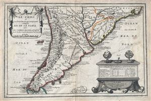
Le Chili et Les Provinces qui Composent Celles de Rio de la Plata avec les Terres Magellanique.
sold
- Digital Map Information
- Suitable for large format printing
- Full resolution TIFF file
- ICC color profile embedded
- Delivered instantly via download link
This is a beautiful 1702 map of southern South America by Nicholas De Fer. It covers from Rio de Janeiro south to the Strait of Magellan and Tierra del Fuego, and includes the modern day nations of Paraguay, Chile, Uruguay and Argentina, with the southern ... (more details)
Uncommon early map of the East Indies.
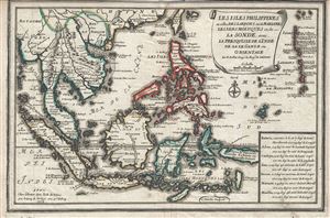
Les Isles Philippines et celles Des Larrons ou de Marianes, Les Isles Moluques et de La Sonde, avec, La Presqu'Isle de l'Inde de la le Gange ou Orientale.
sold
- Digital Map Information
- Suitable for large format printing
- Full resolution TIFF file
- ICC color profile embedded
- Delivered instantly via download link
This is a beautiful and scarce 1702 map of the East Indies by Nicholas De Fer. It covers all of Southeast Asia and the East Indies from the Andaman Islands east to New Guinea and from Taiwan or Formosa south as far as Timor. Includes the modern day ... (more details)
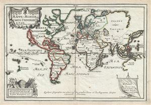
Mappe-Monde ou Carte Universelle.
sold
- Digital Map Information
- Suitable for large format printing
- Full resolution TIFF file
- ICC color profile embedded
- Delivered instantly via download link
This is a scarce and important 1702 Nicholas de Fer map of the world which depicts the entire world according to its 17th century conception. The map is adorned by a beautiful title cartouche in the upper left quadrant and another illustration depicting a globe and flags is featured in the lower left quadrant. Spanish possessions are noted with boundaries color coded in red outline. Routes around the world are illustrated, as are a host of other interesting features. (more details)
A lovely map of the world illustrating California as an island.
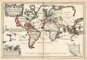
Mappe-Monde ou Carte Universelle.
sold
- Digital Map Information
- Suitable for large format printing
- DPI: 600
- File Size: 9.15 MB
- File Type: ZIP / TIFF
- ICC color profile embedded
- Delivered instantly via download link
This is a scarce and important 1702 Nicholas de Fer map of the world which depicts the entire world according to its 17th century conception. The map is adorned by a beautiful title cartouche in the upper left quadrant and another illustration depicting a globe and flags is featured in the lower left quadrant. Spanish possessions are noted with boundaries color coded in red outline. Routes around the world are illustrated, as are a host of other interesting features. (more details)
First published map to show Fra. Kino's explorations. Includes California as an Island!
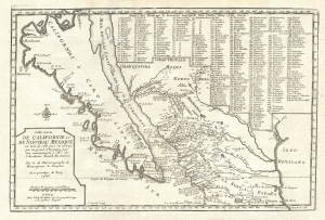
Cette Carte de Californie et du Nouveau Mexique, est tiree de celle qui a ete envoyee par un grand d'Espagne pour etre communiquee a Mrs. De L'Academie Royale des Sciences.
sold
- Digital Map Information
- Suitable for large format printing
- DPI: 300
- File Size: 4.45 MB
- File Type: ZIP / TIFF
- ICC color profile embedded
- Delivered instantly via download link
A landmark 1705 map illustrating California as an island and the first published dissemination of Fr. Eusebio Frabcusci Kino's groundbreaking explorations in New Mexico and California. Drawn by Nicolas de Fer, official Geograph de Monseigneur le Dauphin, this map covers from Cape Mendocino (California) to the Gulf of Mexico and the mouth of the Mississippi River (mis-mapped) and from Santa Fe to Mexico City. Place names are identified both textually and numerically referencing a table of 314 specific locations in the upper right quadrant. (more details)