
Norris, George E. (sold)

George E. Norris (September 29, 1855 – August 18, 1926) was an American hotelier, publisher, and bird's-eye view artist based in Brockton, Massachusetts during the latter part of the 19th century. Norris was born in Massachusetts, likely his lifelong hometown, Brockton. Norris began publishing views in partnership with Albert F. Poole (1853 - 1934), an established viewmaker who, at the time, was renting a house in Brockton from Norris' mother. His first views, most of which were signed by Poole, were published in 1883. In 1884, Norris partnered with Henry Wellge (1850 - 1917), publishing out of Brockton as Norris and Wellge, and later out of Milwaukee as Norris, Wellge and Co. Norris began drawing views independently around 1887. Most of these were initially printed in lithograph by Lucien Burleigh of Troy, New York. Around 1890, Norris switched printers and began using a more modern photomechanical technique, likely Albertype, a style of collotype printing. Although unattributed on any of Norris's post 1890 views, the pioneers of Albertyping in the United States were Adolph (1845 - 1938) and Herman L. Wittemann, who founded the Albertype Company in Brooklyn, New York in 1890 - corresponding perfectly to Norris' change in printers. In total, Norris produced about 135 individual city views. In 1897 he left the view business to open a hotel, the Hotel Norris, in Brockton. Meeting some success as a hotelier, in 1912 he also acquired the Hotel Grayson, also in Brockton. He ran this until his death of cerebral hemorrhage in 1926.
Carriage making capital of the world.
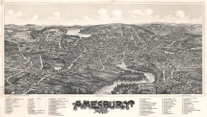
Amesbury, Mass.
sold
- Digital Map Information
- Suitable for large format printing
- File Size: 58.87 MB
- File Type: ZIP / TIFF
- ICC color profile embedded
- Delivered instantly via download link
A stunning George E. Norris and Lucian Burleigh bird's-eye view and map of Amesbury, Essex County, Massachusetts. The view follows the Great Amesbury Fire of 1888, when much of the town center burnt to the ground - here rapid rebuilding and urban renewal give evidence to the city's resilience and prosperity.The view looks northeast on Amesbury from a high point above the Merrimack River. The Powwow River, which runs through town, appears at center. Mt. Prospect cemetery appears in the lower right. Main Street angles in from the lower left corner until it changes to School Street at the top center. Some 92 important locations are noted, ranging from schools and churches to local businesses. A rakish art nouveau title gives evidence of the emerging aesthetic. (more details)
One of only 2 known examples of this rare bird's eye view of Stonington, Maine.
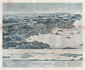
Green's Landing, ME.
sold
- Digital Map Information
- Suitable for large format printing
- File Size: 12.55 MB
- File Type: ZIP / TIFF
- ICC color profile embedded
- Delivered instantly via download link
An extremely rare George E. Norris Bird's-Eye view and map of Stonington, then Greens Landing, Deer Isle, Maine. The view presented Stonington seen as if looking northeast from a position high above Green Head. The view presents a charming and prosperous Maine ... (more details)
One of 3 known examples of Norris's view of Kennebunk.
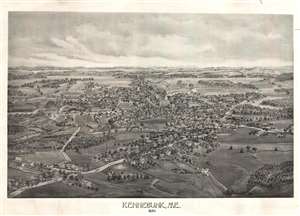
Kennebunk, ME. 1895.
sold
- Digital Map Information
- Suitable for large format printing
- File Size: 10.66 MB
- File Type: ZIP / TIFF
- ICC color profile embedded
- Delivered instantly via download link
This is an extremely rare 1895 George E. Norris bird's-eye view of Kennebunk, Maine – one of Maine's most historic seaside towns. The view is oriented to the west with north to the right. Summer Street appears prominently in the foreground, which transitions ... (more details)
The last of 3.
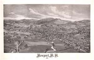
Newport, N.H. 1895.
sold
- Digital Map Information
- Suitable for large format printing
- File Size: 33.17 MB
- File Type: ZIP / TIFF
- ICC color profile embedded
- Delivered instantly via download link
A striking 1895 George E. Norris lithograph view of Newport, a historic town in Sullivan County, New Hampshire. The view looks on Newport from a fictional highpoint to the south. At center the conjunction of various branches of the Sugar River and the town's urban center. To the northwest of the town center the famous Corbin Covered Bridge (today a replica stands here), is recognizable for its tall narrow frame. Another covered bridge, just south of the Sugar River convergence, passes out of town on Elm (today's Maple) Street. Other Newport landmarks on the map include the Court House, Town Hall, Railroad Depot, First Burying Ground, Phenix Hotel, Newport House, Flannel Mills, Kimball's Machine Shop, and the Newport Union Carriage Factory. (more details)
View illustrating Sugarloaf, Maine's most popular ski resort.
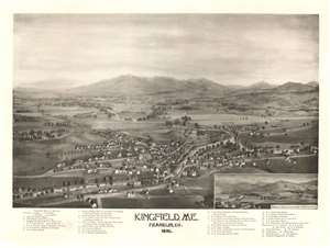
Kingfield, ME. Franklin. Co. 1895.
sold
- Digital Map Information
- Suitable for large format printing
- File Size: 42.56 MB
- File Type: ZIP / TIFF
- ICC color profile embedded
- Delivered instantly via download link
A superb 1895 George E. Norris aquatint bird's-eye view of Kingfield, Maine. The view looks west on Kingfield from a hypothetical highpoint to the east of town, across the Carrabassett River. The primary streets of the town on both sides of the river are noted, as are private residences, service facilities, shops, hotels, and government offices. Behind the town some of Maine's most famous mountains are visible, including Sugarloaf Mountain (now a ski resort), Mt. Abraham, Mt. Redington, and Crocker Mountain. An inset in the lower right looks north from Maple Street to Bigelow Mountain. (more details)