
Southard, Frank Randolph (sold)

Frank Randolph Southard (1886 - 1958) was an American painter, graphic artist, book illustrator, and photographer based in Brooklyn, New York. Southard was born in New Jersey, the son of Charles F. Southard and Katharine Emilie Keller. Southard graduated with a degree in graphic design from Pratt and studied at the Art League of Manhattan. Southard lived most of his life in Brooklyn at 1388 Dean Street. He was an avid touring cyclist and traveled extensively in Europe just prior to World War I. After returning to Brooklyn, he became licensed as a teacher of commercial design. When war broke out he joined the Army where he was assigned to the 77th Division. After the war he returned to New York where he continued to peruse his teaching and artistic career. Southard is known for numerous graphic illustrations including maps of Brooklyn and a notable pictorial wall map of China. He was married to Ida Hinsch and was survived by two children.
The largest American pictorial map of China to predate World War II.
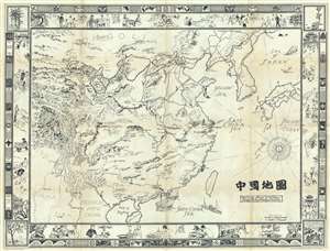
Picture Map of China. 中國地圖
sold
- Digital Map Information
- Suitable for large format printing
- File Size: 42.98 MB
- File Type: ZIP / TIFF
- ICC color profile embedded
- Delivered instantly via download link
This is a striking large format 1932 pictorial wall map of China illustrated by Frank Randolph Southard in 1932. The map covers all of China as well as neighboring Korea and parts of Japan. It is surrounded by an elaborate decorative border featuring Chinese ... (more details)
The largest American pictorial map of China to predate World War II.
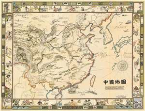
Picture Map of China. 中國地圖
sold
- Digital Map Information
- Suitable for large format printing
- File Size: 89.86 MB
- File Type: ZIP / TIFF
- ICC color profile embedded
- Delivered instantly via download link
This is a striking large format 1932 pictorial wall map of China illustrated by Frank Randolph Southard in 1932. The map covers all of China as well as neighboring Korea and parts of Japan. It is surrounded by an elaborate decorative border featuring Chinese iconography as well as views of Chinese street and country life. The map embraces the romanticized view of Chinese life and culture that many Americans held before World War II. It is moreover, the only large format American pictorial map of China to be issued before the war. While the present map is uncolored, Southard intended the map to be colorized by the buyer. (more details)
Illustrates numerous Brooklyn landmarks, including the Brooklyn Academy of Music, Prospect Park, and the Brooklyn Bridge.
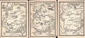
Brooklyn 1636 - 1776 / Brooklyn 1865 - Today / Brooklyn Townships
sold
- Digital Map Information
- Suitable for large format printing
- File Size: 3.8 MB
- File Type: ZIP / TIFF
- ICC color profile embedded
- Delivered instantly via download link
These are three Frank Randolph Southard pictorial maps of Brooklyn, New York. Each of the three maps depicts roughly the same geographic area, from Manhattan and the East River to the Atlantic Ocean and from The Narrows and New York Bay to Jamaica Bay. The ... (more details)