
Chapin Jr., Robert M.

Robert M. Chapin Jr. (fl. 1933 - 1970) was a prominent architect, cartographer and illustrator active during World War II and the Cold War. Chapin graduated from the University of Pennsylvania in 1933 with a degree in architecture. Since this was the height of the Great Depression, and architects in low demand, he instead took work as a staff cartographer at Newsweek. Catching the attention of Manfred Gottfried of Time, Chapin was offered an accepted a position at the head of Time's cartography department. He remained with Time for some 33 years, from 1937 to 1970, often drawn 2 - 3 new thematic maps weekly. With an architect's gift visualizing information, Chapin became a skilled informational cartographer, heading the cartography department at Time Magazine. Chapin, like Fortune Magazine chief cartographer, Richard Edes Harrison, Chapin was at the forefront of infographic propaganda cartography, a genre that matured during the World War II Era and remains popular today. Working for Time Magazine, Chapin developed a signature style for his long run of 'War Maps.' Chapin was known for his maverick airbrush technique which lead to strong color splashes and intense shading. He also incorporated celluloid stencils to illustrate bomb explosions, flags, sinking ships, and more - generating a instantly recognizable standardized style. Chapin's Time war maps were further distinctive for their use of strong bold reds as a universal symbol of hostility. Chapin graduated from the University of Pennsylvania in 1933 with a degree in architecture. Since this was the height of the Great Depression, an d architects in low demand, he instead took work as a staff cartographer at Newsweek. Catching the attention of Manfred Gottfried of Time, Chapin was offered an accepted a position at the head of Time's cartography department. He remained with Time for some 33 years, from 1937 to 1970, often drawn 2 - 3 new thematic maps weekly. Chapin live in Sharon Connecticut.
A large-format map made for TIME Magazine focused on World War II in North Africa only two weeks after the Operation Torch landings.
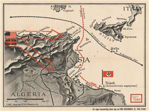
Algeria.
$400.00
Acquire
- Digital Map Information
- Suitable for large format printing
- File Size: 75.43 MB
- File Type: ZIP / TIFF
- ICC color profile embedded
- Delivered instantly via download link
This is a separate issue 1942 Robert M. Chapin, Jr. map of Algeria and Tunisia issued during the World War II North African Campaign. Large red arrows illustrate the American and British forces advancing from the west through Algeria toward Rommel's Afrika Korps in Tunisia. A black dashed line follows Allied supply lines west to Gibraltar and east to Alexandria with the island fortress of Malta at center. Rommel's supply line from Genoa is marked in red. (more details)
War in the Atlantic and Pacific.
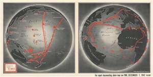
[In the Pacific. In the Atlantic.]
$400.00
Acquire
- Digital Map Information
- Suitable for large format printing
- File Size: 90.16 MB
- File Type: ZIP / TIFF
- ICC color profile embedded
- Delivered instantly via download link
This is a separately issued large-format 1942 Robert M. Chapin, Jr. map of the Pacific and Atlantic Oceans during World War II. Chapin presents the war situation in each of the world's major oceans from an American perspective for TIME Magazine's readers. Both maps emphasize wartime strategies, realities, and conditions specific to each ocean. (more details)
Celebrates the Red Army's victories in the summer and fall of 1943 and hopes for more during the winter months.
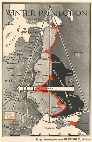
Winter Projection.
$400.00
Acquire
- Digital Map Information
- Suitable for large format printing
- File Size: 83.6 MB
- File Type: ZIP / TIFF
- ICC color profile embedded
- Delivered instantly via download link
This separately-issued large-format 1943 Robert M. Chapin map of Eastern Europe during World War II celebrates Russian victories on the Eastern Front in the late summer and fall of that year. When this map was published, the Soviets were on the cusp of pushing the Wehrmacht out of Russia's pre-1939 borders. Territory shaded black highlights the ground regained by the Russians, while red arrows bring the viewer's focus to areas of renewed offensives. Chapin employs geometry to 'project' just how far the Red Army could push the Germans in the coming months as the hearty Russian army choose to ignore the onset of winter and keep attacking the retreating Germans. (more details)
Freedom for civilian aviation after World War II?
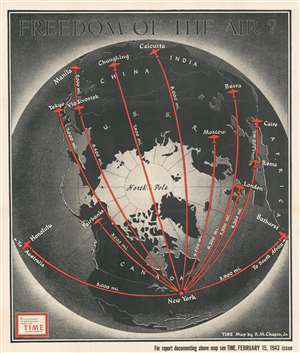
Freedom of the Air?
$500.00
Acquire
- Digital Map Information
- Suitable for large format printing
- File Size: 87.48 MB
- File Type: ZIP / TIFF
- ICC color profile embedded
- Delivered instantly via download link
This is a 1943 Robert M. Chapin, Jr. map of the Northern Hemisphere and its great circle aviation routes. Red lines highlight eleven great circle routes from New York to points across the hemisphere, including London, Rome, Tokyo, Moscow, Calcutta, Fairbanks, and Honolulu. Each route's distance from New York appears in miles and silhouettes of the iconic DC-3 / C-47 mark each city. (more details)
Makes an effort at preparing the American people for a long, bloody war in the Pacific against Japan.
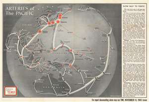
Arteries of the Pacific.
$400.00
Acquire
- Digital Map Information
- Suitable for large format printing
- File Size: 137.12 MB
- File Type: ZIP / TIFF
- ICC color profile embedded
- Delivered instantly via download link
This is an enlarged, separate issue version of a 1943 Robert M. Chapin, Jr. pictorial map of the Pacific Ocean fortifications and supply routes at the height of the Pacific War during World War II. Wonderfully compiled, the map depicts the region from India to Hawaii and from Kamchatka and the Aleutian Islands to Australia and New Zealand. Concise and clear iconography is used to delineate both American and Japanese fortifications and supply lines, allowing viewers to easily comprehend the strategic reality of the Pacific War. Icons in the shape of shore guns mark the fortified locations of both Japan and the United States, with white 'arteries' connecting them all. Moreover, a very frank text along the right border explains in no uncertain terms why the Pacific campaign has been so much more difficult for the Americans than it was for the Japanese in late 1941 and the first half of 1942. One of the many important factors in the relating to the American advance pointed out the reality of a 10,000-mile supply line between where combat was taking place and the California coast. The establishment and protection of this 'artery' was essential. Another such factor was that the Japanese had the advantage of attacking unfortified positions, while the Americans, in order to roll back Japan's conquests, had to land troops on beachheads on heavily fortified islands. (more details)
Highlights Generals Stillwell and Mountbatten's 1944 assaults on Japanese-occupied Burma.
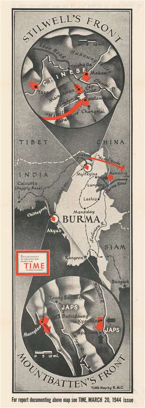
Stilwell's Front. Mountbatten's Front.
$400.00
Acquire
- Digital Map Information
- Suitable for large format printing
- File Size: 45.71 MB
- File Type: ZIP / TIFF
- ICC color profile embedded
- Delivered instantly via download link
Created during the beginning of the 1944 World War II Allied offensive to liberate Burma from the Japanese, this is a 1944 Robert M. Chapin, Jr. map of Burma. Two circular insets detail both battlefronts, commanded by American General Joseph Stilwell and British Admiral Louis Mountbatten. Red arrows highlight the Allied advance in both sectors. Stilwell's forces (depicted in the top inset) marched through northern Burma and reopened the critical Ledo Road, an overland supply route to Chiang Kai-shek's nationalist Chinese forces. Mountbatten's army (bottom circular inset) attacked Japanese forces farther south along the Indian Ocean. (more details)
Climax of World War II in Burma.
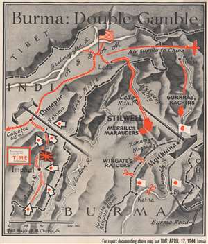
Burma: Double Gamble.
$400.00
Acquire
- Digital Map Information
- Suitable for large format printing
- File Size: 90.59 MB
- File Type: ZIP / TIFF
- ICC color profile embedded
- Delivered instantly via download link
This is a large format separately issued 1944 Robert M. Chapin Jr. map of northeastern India and northern Burma. The map depicts the simultaneous Japanese 'Operation U Go' and the 'Allied Myitkyina Offensive' as they were happening - thus representing the climax of World War II in Burma. Red lines in India mark the railway line connecting Calcutta with Dimapur and the airfields to Dimapur's north. These airfields were the only way for Allied supplies to reach Chiang Kai-shek and the Chinese nationalists, as the Burma Road had been severed in 1942 by a Japanese attack. Dimapur was also the main communication link between Allied commanders in Calcutta and the troops fighting the Myitkyina Offensive. Both these facts made Dimapur a prime target for the Japanese. Parallel red lines into Burma mark the road from Dimapur to Kohima and Imphal, as well as the general direction followed by General Stilwell during the Myitkyina Offensive. Merrill's Marauders, Wingate's Raiders, and the Gurkhas and Kachins, all irregular Allied fighting forces, are referenced as well. (more details)
Predicted months of brutal fighting in Romania and Bulgaria in the spring and summer of 1944.
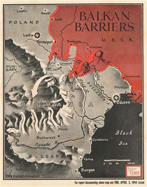
Balkan Barriers.
$300.00
Acquire
- Digital Map Information
- Suitable for large format printing
- File Size: 96.95 MB
- File Type: ZIP / TIFF
- ICC color profile embedded
- Delivered instantly via download link
Published during the 1944 World War II Red Army offensives on the Eastern Front, this 1944 Robert M. Chapin Jr. map of Romania, Bulgaria, and Ukraine emphasizes Soviet gains in the region. Red arrows, indicating Soviet troops, push south forcing white arrows, representing Axis forces, to retreat. Major cities, including Odessa, Lwów (now Lviv, Ukraine), Bucharest, and Sofia, stand in the Red Army's path. This map was produced to illustrate an article lauding the Red Army's impressive drive across Ukraine. (more details)
Published between the third and fourth Allied assaults on Monte Cassino, a key strongpoint in German defenses in central Italy.
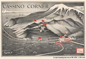
Cassino Corner.
$700.00
Acquire
- Digital Map Information
- Suitable for large format printing
- File Size: 88.33 MB
- File Type: ZIP / TIFF
- ICC color profile embedded
- Delivered instantly via download link
Highlighting the bloody campaign to liberate Italy during World War II, this 1944 Robert M. Chapin, Jr. map of Monte Cassino was published before the Battle of Monte Cassino was decided. Monte Cassino was the lynchpin of the Axis Winter Line, a series of defensive lines that stretched across the Italian peninsula from the Adriatic Sea to the Tyrrhenian Sea. Constructed to defend Rome, the Winter Line withstood Allied attacks from December 1943 until June 1944, when it was finally fell in the face of the fourth Allied assault. (more details)
Where will the U.S. strike next?
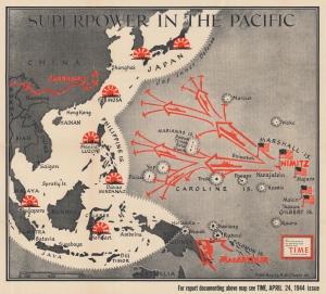
Superpower in the Pacific.
$400.00
Acquire
- Digital Map Information
- Suitable for large format printing
- File Size: 80.47 MB
- File Type: ZIP / TIFF
- ICC color profile embedded
- Delivered instantly via download link
This is a 1944 Robert M. Chapin Jr. map of the then-current situation in the Pacific Theater during World War II (1939 - 1945). It illustrates the 'leapfrogging' tactic by which U.S. Forces crossed the vast Pacific to get within striking distance of Imperial Japan. (more details)
Anticipating the Allied invasion of Normandy.
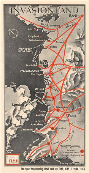
Invasionland.
$550.00
Acquire
- Digital Map Information
- Suitable for large format printing
- File Size: 68.61 MB
- File Type: ZIP / TIFF
- ICC color profile embedded
- Delivered instantly via download link
Perhaps the worst best-kept secret of World War II, by the spring of 1944 everyone was anticipating the Allied invasion of Northern Europe. This map, created by Robert M. Chapin, Jr., encapsulates that anticipation, speculating where American and British forces would land. Here, numerous locations along the coast are identified, including Calais (which was believed to be the most likely location for the invasion), Dunkirk (the site of the storied evacuation of British and French troops), Cherbourg, Brest, and even Wilhelmshaven, the German submarine base. The thick red lines indicate major railways, where it would be easiest for the Germans to quickly relocate forces in response to an invasion. The swastikas inscribed in red circles mark 'command forts' constructed by Rommel to help repel the expected invasion. (more details)