
Chapin Jr., Robert M. (sold)

Robert M. Chapin Jr. (fl. 1933 - 1970) was a prominent architect, cartographer and illustrator active during World War II and the Cold War. Chapin graduated from the University of Pennsylvania in 1933 with a degree in architecture. Since this was the height of the Great Depression, and architects in low demand, he instead took work as a staff cartographer at Newsweek. Catching the attention of Manfred Gottfried of Time, Chapin was offered an accepted a position at the head of Time's cartography department. He remained with Time for some 33 years, from 1937 to 1970, often drawn 2 - 3 new thematic maps weekly. With an architect's gift visualizing information, Chapin became a skilled informational cartographer, heading the cartography department at Time Magazine. Chapin, like Fortune Magazine chief cartographer, Richard Edes Harrison, Chapin was at the forefront of infographic propaganda cartography, a genre that matured during the World War II Era and remains popular today. Working for Time Magazine, Chapin developed a signature style for his long run of 'War Maps.' Chapin was known for his maverick airbrush technique which lead to strong color splashes and intense shading. He also incorporated celluloid stencils to illustrate bomb explosions, flags, sinking ships, and more - generating a instantly recognizable standardized style. Chapin's Time war maps were further distinctive for their use of strong bold reds as a universal symbol of hostility. Chapin graduated from the University of Pennsylvania in 1933 with a degree in architecture. Since this was the height of the Great Depression, an d architects in low demand, he instead took work as a staff cartographer at Newsweek. Catching the attention of Manfred Gottfried of Time, Chapin was offered an accepted a position at the head of Time's cartography department. He remained with Time for some 33 years, from 1937 to 1970, often drawn 2 - 3 new thematic maps weekly. Chapin live in Sharon Connecticut.
Highlights the realities of a possible war between the United States and Japan in the Pacific.
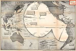
U.S. v. Japan The Pacific Problem.
sold
- Digital Map Information
- Suitable for large format printing
- File Size: 97.93 MB
- File Type: ZIP / TIFF
- ICC color profile embedded
- Delivered instantly via download link
This is a rare 1940 Robert M. Chapin, Jr. map of the Pacific Ocean and the potential for war between the United States and the Empire of Japan. Stretching from Asia to the Americas and from Alaska to New Zealand and Cape Horn, Chapin highlights areas that could become battlegrounds if the tensions between the U.S. and Japan boiled over into war. Black and white stripes identify the United States, a deliberate reference to the American flag. It is worth noting that the Philippines, an archipelago in the East Indies, is also shaded with this pattern, as the islands were a U.S. possession in 1940. Japanese territory is black, including Manchukuo, the puppet state the Japanese created in northeastern China, Taiwan (Formosa), and Hainan.
With the benefit of hindsight, modern viewers know what lies ahead, but Chapin and those viewing this map in TIME Magazine in 1940 could only guess. Islands across the Pacific are labeled and captions provide context for the most important locations. The Hawaiian Islands, specifically Pearl Harbor, are one such location, with a caption providing distances between the naval base and San Francisco, Tokyo, and Manila, the capital of the Philippines. The American base at Dutch Harbor, Alaska is also among the locations singled out, as is Guam, and island in the Western Pacific and a U.S. possession, but unfortified and poorly defended. The map also posits that the Panama Canal Zone, then occupied by the United States, could be used as a base for the fleet. Two large circles emanate across the Pacific from the Americas and Hawaii, illustrating just how far the American military can reach. This clearly informs the viewer in no uncertain terms that as of the publication of this map, the U.S. military is unable to reach the Western Pacific and Japan.
The Japanese position, however, appears to be much stronger. By 1940, the Japanese had been fighting in Asia for nine years and, as Chapin points out, had recently gained a foothold in French Indochina, a benefit gained from Nazi Germany's stunning defeat of France in June. Japanese fortified islands in the Marshall Islands and Marianas Islands are also highlighted, creating a stark contrast between Japanese and American preparedness in the region. These islands, Saipan, Jaluit, and Truk to name a few, are relatively close to Guam, and the Japanese have taken the time to fortify them, while the American have left Guam essentially undefended. Chapin also posits the question of whether or not the United States would fight for oil, rubber, and tin in the Dutch East Indies (Java, Sumatra, Borneo), and quickly states that Japan would, creating yet another noticeable difference between the two powers.
Yet another important comparison is drawn by an infographic along the bottom border: the relative tonnage of the U.S. Navy and Japanese Navy are compared side by side. The strength of each country's battleships, cruisers, aircraft carriers, destroyers, and submarines are all compared, and the U.S. tops Japan in nearly every category. This advantage, though important, would be difficult to maintain in the beginning stages of the coming war. But Japan was not completely outnumbered, as their greatest advantages, their technological superiority in torpedoes and fighter planes for example, more than made up for slightly less in naval tonnage. (more details)
With the benefit of hindsight, modern viewers know what lies ahead, but Chapin and those viewing this map in TIME Magazine in 1940 could only guess. Islands across the Pacific are labeled and captions provide context for the most important locations. The Hawaiian Islands, specifically Pearl Harbor, are one such location, with a caption providing distances between the naval base and San Francisco, Tokyo, and Manila, the capital of the Philippines. The American base at Dutch Harbor, Alaska is also among the locations singled out, as is Guam, and island in the Western Pacific and a U.S. possession, but unfortified and poorly defended. The map also posits that the Panama Canal Zone, then occupied by the United States, could be used as a base for the fleet. Two large circles emanate across the Pacific from the Americas and Hawaii, illustrating just how far the American military can reach. This clearly informs the viewer in no uncertain terms that as of the publication of this map, the U.S. military is unable to reach the Western Pacific and Japan.
The Japanese position, however, appears to be much stronger. By 1940, the Japanese had been fighting in Asia for nine years and, as Chapin points out, had recently gained a foothold in French Indochina, a benefit gained from Nazi Germany's stunning defeat of France in June. Japanese fortified islands in the Marshall Islands and Marianas Islands are also highlighted, creating a stark contrast between Japanese and American preparedness in the region. These islands, Saipan, Jaluit, and Truk to name a few, are relatively close to Guam, and the Japanese have taken the time to fortify them, while the American have left Guam essentially undefended. Chapin also posits the question of whether or not the United States would fight for oil, rubber, and tin in the Dutch East Indies (Java, Sumatra, Borneo), and quickly states that Japan would, creating yet another noticeable difference between the two powers.
Yet another important comparison is drawn by an infographic along the bottom border: the relative tonnage of the U.S. Navy and Japanese Navy are compared side by side. The strength of each country's battleships, cruisers, aircraft carriers, destroyers, and submarines are all compared, and the U.S. tops Japan in nearly every category. This advantage, though important, would be difficult to maintain in the beginning stages of the coming war. But Japan was not completely outnumbered, as their greatest advantages, their technological superiority in torpedoes and fighter planes for example, more than made up for slightly less in naval tonnage. (more details)
Details the Nazi invasion of Belgium and the Netherlands in May 1940 at the beginning of the Spring Offensive.
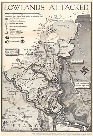
Lowlands Attacked.
sold
- Digital Map Information
- Suitable for large format printing
- File Size: 66.18 MB
- File Type: ZIP / TIFF
- ICC color profile embedded
- Delivered instantly via download link
This is a large-format separate issue 1940 Robert M. Chapin Jr. pictorial map of Belgium and the Netherlands during the German invasion of Western Europe. Published only ten days after the Nazis launched their assault, the map depicts the region from Dunkirk to Wilhemshaven and from the North Sea to Paris. Thick black arrows marked with swastikas identify the German drive west, while white tipped arrows highlight the British and French response. Explosions mark cities and airfields bombed the week before, and icons of paratroopers present where German parachute landings took place. (more details)
Predicting an Allied assault in Africa published three weeks before Operation Torch.
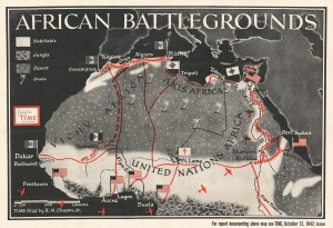
This is a separately issued large-format 1942 Robert M. Chapin, Jr. map of North Africa. Focusing on the northern half of the continent, red lines connect major population centers and flags identify European occupation. In an intriguing detail, Vichy French-occupied cities are marked by flags bearing swastikas, leaving little doubt as to how the editors of TIME viewed Pétain's regime. Rail lines between Casablanca, Oran, Bizerte, and Timbuktu are illustrated, as are lines between Cairo and Eritrea. Airplane silhouettes reference the air resupply route between the United States and Cairo via West Africa. (more details)
Possible Allied invasion routes to Berlin.
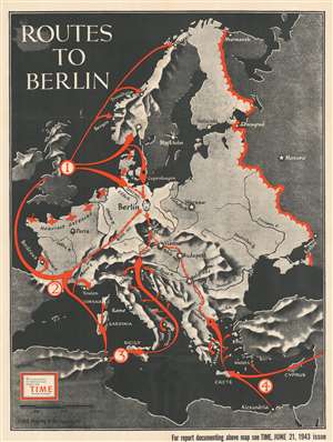
Routes to Berlin.
sold
- Digital Map Information
- Suitable for large format printing
- File Size: 96.1 MB
- File Type: ZIP / TIFF
- ICC color profile embedded
- Delivered instantly via download link
This is a large, separately issued 1943 Robert M. Chapin, Jr. map Europe. Created for TIME, the map illustrates four possible Allied invasion strategies proposed by Colonel Conrad H. Lanza, U.S. Army (ret.) (1878 - 1963) in an article published in the June 1943 issue of the Field Artillery Journal. In this article, Colonel Lanza discussed potential Allied invasion points around continental Europe, although he did not attempt to predict where or when an invasion would take place. Each of Lanza's plans focused on the central Allied objective - capturing Berlin. Here, Chapin and TIME detail four of his proposed possibilities. The first involved an invasion of Norway between Oslo and Kristiansand, which would also necessitate landings on the western and northern Norwegian coasts are diversions. The Allies would then have a shorter distance to travel between Norway and Berlin but would have to combat large concentrations of enemy soldiers in a relatively small geographic area. This plan would also force the Allies to forcibly liberate Copenhagen, which would be a difficult task to say the least. Possible landings in Belgium and the Netherlands were also included by Chapin in this first possibility. Lanza's second proposal illustrated here involved invading southwestern France along the Spanish border from the Atlantic and Mediterranean coasts nearly simultaneously. The third option took advantage of Allied positions in Sicily, Sardinia, and Corsica to land troops in the northern Adriatic. Lanza proposed this option, it appears, because western Italy's terrain (the Alps and several major rivers) made invading Germany from there much more difficult. The final option depicted here is an Allied invasion of the continent through the Aegean Sea and Greece. Lanza pointed to the difficulties presented by German-held islands in the Aegean alongside the distances involved (on the order of 950 miles) and implied that this strategy was unlikely. (more details)
Highlights the progress of the Allied push against Japan in the Pacific all the while getting closer to Japan itself.
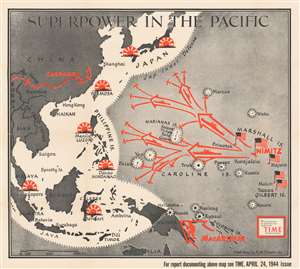
Superpower in the Pacific.
sold
- Digital Map Information
- Suitable for large format printing
- File Size: 90.24 MB
- File Type: ZIP / TIFF
- ICC color profile embedded
- Delivered instantly via download link
This is a 1944 Robert M. Chapin Jr. map of the then-current situation in the Pacific Theater during World War II. The map depicts the region from Burma and China to the Gilbert Islands and from Japan to northern Australia. (more details)
Highlights the Allied landing at Anzio only nine days afterward.
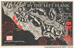
By the Left Flank.
sold
- Digital Map Information
- Suitable for large format printing
- File Size: 62.17 MB
- File Type: ZIP / TIFF
- ICC color profile embedded
- Delivered instantly via download link
This is a 1944 Robert M. Chapin, Jr. map of central Italy the week after the Allied landing at Anzio. The map depicts the region from the Mediterranean Sea to Atina and Sora and from Rome to Miturno and Cassino. Red icons are used to mark the Allied landing at Anzio, which took place on January 22, 1944, in an effort to break the stalemate along the German 'Gustav Line' at Cassino. Barbed lines highlight the German's fortified positions in front of the advancing American, British, and French troops who had been advancing north from Salerno since September 1943. Roads are illustrated in white, with the regions rivers also noted. (more details)
The Soviet Red Army advancing in eastern Europe.
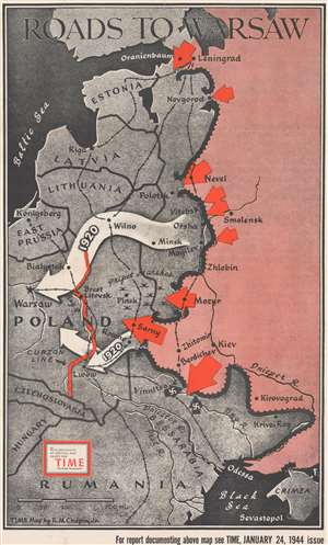
Roads to Warsaw.
sold
- Digital Map Information
- Suitable for large format printing
- File Size: 83.4 MB
- File Type: ZIP / TIFF
- ICC color profile embedded
- Delivered instantly via download link
This is a separately issued large format 1944 Robert M. Chapin Jr. map of eastern Europe and Russia illustrating the Soviet Red Army's advance. Large red arrows highlight combat areas. The largest arrows at Sarny, Vinnitsa, and Mozyr highlight important Soviet successes in breaking through the German lines. At the time of publication, a massive battle was underway at Vitebsk and the army near Mozyr was pushing through the Pripet Marshes toward Pinsk. The army at Sarny had just cut an important north-south rail line and was quickly advancing on the Lwow-Konigsberg rail line. The large white arrows reference the Red Army's 1920 march on Warsaw, when they reached the city but failed to defeat the Polish army. (more details)
An anti-Communist map of Eastern Europe promoting Soviet imperial ambitions.
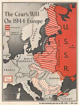
The Czar's Will on 1944 Europe.
sold
- Digital Map Information
- Suitable for large format printing
- File Size: 95.94 MB
- File Type: ZIP / TIFF
- ICC color profile embedded
- Delivered instantly via download link
Dating from an era when the United States was fighting a truly global war against Nazi Germany and Imperial Japan, this 1944 Robert M. Chapin Jr map of Eastern Europe takes aim at neither of America's two official enemy states, but one of its allies. The map depicts the region from England and Scotland to the U.S.S.R and from the Arctic Ocean to Turkey and warns of the 'czar's will' to annex and exert influence over vast swaths of Eastern Europe. The Soviet Union is shaded red, a color traditionally associated with Communism, and is illustrated within its 1939 borders, while western Europe is shaded gray. The space in between, the areas the Soviets are supposedly eyeing, are shaded with two different patterns of red and white stripes. Parts of Europe that are apparently going to be annexed, shaded with thick red stripes and thin white stripes, include Finland, all three of the Baltic states (Estonia, Latvia, and Lithuania), Poland, eastern Germany, and eastern Romania. The Bosporus and the Dardanelles are also going to be annexed (which means Istanbul would fall into Soviet hands), finally satiating Russian desires for a secure warm-water port along the Black Sea. This would effectively make the Soviet Union an imperial power in Eastern Europe, replacing the hegemony of the Nazis. It must not be forgotten, however, that direct control is not the only method referenced here. Czechoslovakia, (more details)
Speculates on the post-war breakup of Germany months before the D-Day invasion of France.
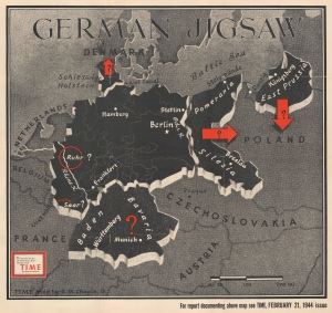
German Jigsaw.
sold
- Digital Map Information
- Suitable for large format printing
- File Size: 61.51 MB
- File Type: ZIP / TIFF
- ICC color profile embedded
- Delivered instantly via download link
This separate-issue large-format Robert M. Chapin Jr. map of World War II Germany speculates about the fate of a post-war Germany. It was published at the end of February 1944, three months before D-Day. (more details)
A striking map of northern Europe speculating on where the Allies would invade in the spring of 1944.
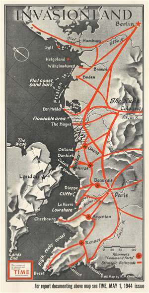
Invasionland.
sold
- Digital Map Information
- Suitable for large format printing
- File Size: 78.3 MB
- File Type: ZIP / TIFF
- ICC color profile embedded
- Delivered instantly via download link
Perhaps the worst best-kept secret of World War II, by the spring of 1944 everyone on the planet was waiting for the long-awaited Allied invasion of Northern Europe. This map, created by Robert M. Chapin, Jr., encapsulates that anticipation, speculating where American and British forces would land along the northern coast of Europe. Here, numerous locations along the coast are identified, including Calais (which was believed to be the most likely location for the invasion), Dunkirk (the site of the storied evacuation of British and French troops), Cherbourg, Brest, and even Wilhelmshaven, the German submarine base. The thick red lines indicate major railways, illustrating where it would be easiest for the Germans to quickly move their forces to repel the invasion. The swastikas inscribed in red circles mark 'command forts' constructed by Rommel to help repel the expected invasion. (more details)