
Chassant (sold)

Chassant (fl. c. 1830 - 1860) was a French line and chart engraver active in Paris in the middle part of the 19th century. Chassant was active with the French Dépôt de Marine from the 1830s into the 1860s. He was a master engraver and, some have argued, his dramatic hachuring work to illustrate topography suggests he may have been wasted on nautical charts. Most of his engraving was completed in partnerships with Jacques-Marie Hacq (September 22, 1785 – 18??). Chassant did not sign any of his engravings with a first name or other identifier, so it is difficult to track him down. He may be Alphonse Antoine Louis Chassant (August 1, 1808 - September 7, 1907), who in later life was an art historian and librarian of the city of Évreux. He wrote several books, including works on engraving. We cannot alas verify the connection and it may be pure guesswork.
The French-American cotton trade.
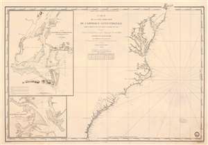
Carte de la Côte Orientale de l'Amérique Septentrionale Partie Comprise Entre New York et la Rivière Saint Jean.
sold
- Digital Map Information
- Suitable for large format printing
- Full resolution TIFF file
- ICC color profile embedded
- Delivered instantly via download link
This is an 1834 French Dépôt-général de la Marine nautical chart or maritime map of the east coast of the United States. The map appeared at the height of the U.S.-French textile trade, which it was likely published to support. Southern ports in Virginia, Carolina, and Georgia provided the bulk of cotton for the French textile industry - a fact that would become a major point of contention during the Civil War (1861 - 1865), leading to the Cotton Famine (1863 - 1863). Depicting from New York City south to the mouth of the St. Johns River in Florida, coastal detail abounds. Depth soundings are indicated along the entire coastline, along with inlets, capes, banks, and coastal islands. The Delaware River is charted to Philadelphia. The Chesapeake Bay is detailed as far as Charlestown and Elkstown. The Potomac River (labeled here as Potomack) is illustrated to Washington, D.C., and the Rappahannock River (labeled here as Rappanahock) runs to Fredericksburg. Both Richmond and Petersburg are labeled along the James River, as is Norfolk. Albemarle and Pamlico Sounds are detailed in North Carolina, and Cape Hatteras, Cape Lookout, and Cape Fear are labeled. Both Charleston and Savannah are identified. (more details)
On the cusp of greatness.
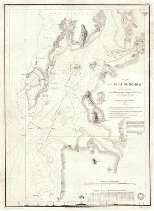
Plan du Port de Bombay.
sold
- Digital Map Information
- Suitable for large format printing
- Full resolution TIFF file
- ICC color profile embedded
- Delivered instantly via download link
This is a rare 1840 / 1843 nautical chart or maritime map of Bombay / Mumbai harbor, India. The map covers from Salsette to Kundaree Island. Detail focuses heavily on the inner harbor, where thousands of depth soundings in meters and trigonometric survey lines are included. This chart, compiled from the survey work of India Navy Lieutenant Robert Cogan represents the first major scientific survey of Bombay Harbor since the late 18th-century work of Captain John Watson. (more details)
Charting both Visits of D'Urville to the Loyalty Islands.
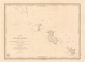
Carte des Iles Loyalty Levée et Dressée par Mr. Vincendon-Dumoulin, Ingenieur Hydrographe de la Marine.
sold
- Digital Map Information
- Suitable for large format printing
- Full resolution TIFF file
- ICC color profile embedded
- Delivered instantly via download link
This is the earliest acquirable detailed chart of the Loyalty Islands (northeast of New Caledonia). It was executed in 1840 by the naval hydrographer Clément Adrien Vincendon-Dumoulin, who participated in the second voyage of the French corvette L'Astrolabe under the command of Jules Sébastien César Dumont d'Urville (1790 - 1842). While the primary goal voyage was the discovery of a presumed southern continent (Antarctica?), the expedition was notable for its contact with many Pacific islands en route. Vincendon-Dumoulin was highly praised for his work during the voyage, both in regard to his surveys of new coastlines from land, and his innovations in charting coastlines whilst under sail. The chart details the islands of Ile Ouvéa, Ile Lifou, and Ile Maré (named Ile Haglan, Ile Chabrol, and Ile Britannia on the chart) along with some other smaller islands in the archipelago. Vincendon-Dumoulin includes the tracks not only of the 1840 expedition he attended, but also the track taken by L'Astrolabe in its earlier 1828 Pacific voyage. A further track is shown: that of Antoine Raymond Joseph de Bruni d'Entrecasteaux (1737 - 1793), who undertook a journey to the Pacific in 1792 - 1793 in search of the lost expedition of La Perouse(1741 - 1788), whose ship, L'Astrolabe, was the namesake of the lead vessel in D'Urville's journeys. (more details)
Earliest obtainable modern chart of the Maldives.
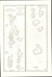
Carte des Iles Maldives. No. 942.
sold
- Digital Map Information
- Suitable for large format printing
- File Size: 28.83 MB
- File Type: ZIP / TIFF
- ICC color profile embedded
- Delivered instantly via download link
This is a rare large-format 1841 French Dépôt-général de la Marine nautical chart of the Maldives Islands in the Indian Ocean. Based on a now-unobtainable 1838 British chart by Robert Moresby, the first modern hydrographic survey of the islands, this is the earliest obtainable specific modern chart of the Maldives. (more details)
French interest in the Caribbean and a Nicaragua Canal.
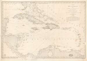
Carte des Antilles Dressée par M. Keller, Ingénieur Hydrographe de 2e Classe, d'après les travaus les plus récents.
sold
- Digital Map Information
- Suitable for large format printing
- DPI: 600
- File Size: 35.02 MB
- File Type: ZIP / TIFF
- ICC color profile embedded
- Delivered instantly via download link
This is the 1862 edition of the Dépôt de la Marine / Francois-Antoine-Edouard Keller nautical chart of the West Indies. It is the most general of Keller's West Indies charts reflecting the full scope of his definitive surveys - the coverage embracing the full Caribbean Basin from the Yucatan to Barbados and from Florida to Panama and the mouths of the Orinoco. This chart reflects French interest in the region relating to a possible Nicaragua Canal. (more details)
Issued in response to headhunters in South Formosa.
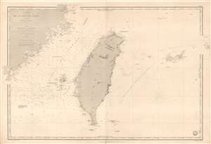
Carte de la Mer de Chine (4eme. Feuille) Détroit de Formose.
sold
- Digital Map Information
- Suitable for large format printing
- File Size: 43.78 MB
- File Type: ZIP / TIFF
- ICC color profile embedded
- Delivered instantly via download link
This is a rare 1873 French Depot de Marine nautical chart of Taiwan / Formosa and vicinity. The map is centered on Taiwan, but includes parts of Fujian, China, the Pescadores / Penghu Islands, and the Yaeyama Islands (Iles Majico Sima). This map was issued at a time when Taiwan was heavily in the news - headhunters of coruse - which can account for the issue and reissue of this chart from 1867 through the present 1873 edition. (more details)