
Denoyer-Geppert Company (sold)

The Denoyer-Geppert Company (1916 - 1984) was a Chicago-based publishing firm that dealt in maps, atlases, and spherical cartography (globes). For 68 years, the company played a critical role in the education of the world’s students. Founded in 1916 by Otto E. Geppert (the salesman) and L. Philip Denoyer (the cartographer/editor). Denier was born in Milwaukee in 1875 and was a high school principal by the age of 32. He was also completing graduate work at the University of Chicago at the same time. He was appointed the first Professor of Geology and Geography at the State Teacher’s College - La Crosse (University of Wisconsin) in 1909. Legend has it that Denoyer met Geppert while teaching one of his classes, when the latter came up from Chicago to sit in on one. Geppert was working as a salesman for A.J. Nystrom and Company, which today self-identifies as ‘the United States’ older publisher of wall maps and globes for classroom use.’ Geppert was there to sell Denoyer on joining the team at Nostrum, believing that his expertise could benefit the company. Three years later they founded the Denoyer-Geppert Company, and within six years had moved from a 500 square foot space into the 50,000 square foot Swedish-American Telephone Building. By 1922, their catalogue consisted of ‘1,200 maps, charts, globes, and associate aids in teaching geography and history and 800 brilliantly illuminated biological charts and anatomical models.’ In 1967, Denoyer-Geppert was contracted by NASA to build the first official and accurate ‘lunar globe’, based on information gathered by Apollo 10 astronauts. The company made 200 of these globes, the first of which was presented by the astronauts of Apollo 10 to President Nixon. Rand McNally, one of their major competitors, bought out their inventory of maps and globes in 1984. Denoyer-Geppert left the Swedish-American Telephone Building and reinvented the company as the Denoyer-Geppert Science Company, which specializes in anatomical models for classrooms. The Swedish-American Telephone Company has been named a historic landmark and was remodeled into loft apartments.
Unusual map of the United States showing embossed relief.
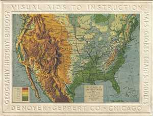
Relief Model of United States.
sold
- Digital Map Information
- Suitable for large format printing
- File Size: 1.37 MB
- File Type: ZIP / TIFF
- ICC color profile embedded
- Delivered instantly via download link
This is an unusual 1911 embossed relief map of the United States issued by the Denoyer-Geppert Company. It covers the entire country including parts of Canada and Mexico. State boundaries are noted. The map also notes several important cities, rivers, lakes and ... (more details)
Allows for a glimpse into the racist tendencies of the United States in the 1920s and 1930s.
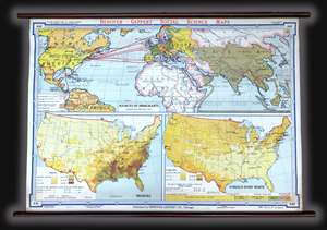
This is a c. 1940s Albert Bushnell Hart and Denoyer-Geppert Company wall map of the world. The map depicts from North America to the Pacific Ocean, Japan, and Indonesia (labeled the Netherlands, Indies) and from the Arctic Circle to just past the Equator. ... (more details)
A striking visual presentation of how the United States expanded from the Atlantic to the Pacific - including the Republic of Texas!
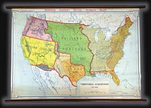
A visually striking piece, this is a c. 1940s Albert Bushnell Hart and Denoyer-Geppert Company wall map of the United States. The map depicts the continental United States from the Pacific Ocean to the Atlantic Ocean and from Canada (labeled British ... (more details)
The growth of the United States explained.
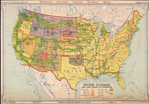
Western Statehood and Land Grants for Railroads.
sold
- Digital Map Information
- Suitable for large format printing
- File Size: 69.4 MB
- File Type: ZIP / TIFF
- ICC color profile embedded
- Delivered instantly via download link
This is a c. 1940s Albert Bushnell Hart and Denoyer-Geppert Company wall map of the United States. The map depicts the continental United States from the Pacific Ocean to the Atlantic Ocean and from Canada to Mexico. As a means of illustrating the westward expansion of the United States, color coding is used to differentiate between states. Through this unique coding structure, the piecemeal expansion of the United States across the continent is easily distinguishable. For example, all the yellow states achieved statehood before 1864, which means that both California and Oregon, on the Pacific coast, became states long before the majority of the states in the Trans-Mississippi West. American Indian reservations established by 1916 are depicted in red. (more details)
Visually depicts the Western Expansion of the United States and the creation of the rail network.
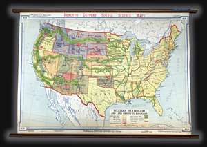
This is a c. 1940s Albert Bushnell Hart and Denoyer-Geppert Company wall map of the United States. The map depicts the continental United States from the Pacific Ocean to the Atlantic Ocean and from Canada to Mexico. As a means of illustrating the ... (more details)
Charter for a better world...
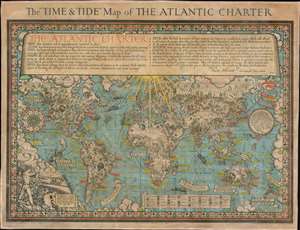
The 'Time and Tide' Map of The Atlantic Charter.
sold
- Digital Map Information
- Suitable for large format printing
- File Size: 70.3 MB
- File Type: ZIP / TIFF
- ICC color profile embedded
- Delivered instantly via download link
This is a 1942 MacDonald Gill pictorial map of the world celebrating the announcement of the Atlantic Charter, a statement of joint American and British goals for the world after World War II. The map depicts the world using Gall's stereographic projection and places Europe and Africa at center with the Americas to the left and Asia to the right. Pictorial symbols highlight resources, giving the map an air of strategic importance, since natural resources were key to the global conflict then raging. Circular vignettes provide insight into the daily lives of people from walks of life, including a Canadian lumberjack, an American farmer, an Arabian trader, and an Australian rancher. Countries are labeled, as are cities and towns, some with banners, others with text. (more details)
Two U.S. Air Force aeronautical charts joined to form one gigantic chart of Southeast Asia during the Vietnam War.
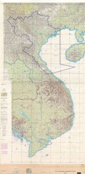
USAF Operations Navigation Chart ONC K-10 / USAF Operations Navigation Chart ONC J-11.
sold
- Digital Map Information
- Suitable for large format printing
- Full resolution TIFF file
- ICC color profile embedded
- Delivered instantly via download link
This is a c. 1970 United States Air Force aeronautical chart of Southeast Asia. The map, which is two charts joined together and mounted on linen, depicts the region from the meridian 102° east of Greenwich to the Leizhou Peninsula and Hainan and ... (more details)