

Partie Septentrionale des Pays Bas, Comprenant Les Etats Generaus des Provinces Unies.
sold
- Digital Map Information
- Suitable for large format printing
- DPI: 300
- File Size: 9.81 MB
- File Type: ZIP / TIFF
- ICC color profile embedded
- Delivered instantly via download link
A beautiful example of Jan Janvier's decorative map of the Low Countries or Pays Bas. Covers modern day Holland and Belgium from Friesland south to France, west to England, and east to Germany. Offers excellent detail throughout showing mountains, rivers, ... (more details)

Mapa dos Reynos de Portugal e Algarve.
sold
- Digital Map Information
- Suitable for large format printing
- DPI: 300
- File Size: 8.46 MB
- File Type: ZIP / TIFF
- ICC color profile embedded
- Delivered instantly via download link
A beautiful example of Rizzi-Zannoni's curious decorative map of southern Portugal, the Algarve, and southwestern Spain. Covers from Lisbon south to Gibraltar and east as far as Andorra, Spain. Engraved in a highly unusual topographic style, this map ... (more details)

Carte des Gouvernements de Lorraine et D'Alsace.
sold
- Digital Map Information
- Suitable for large format printing
- DPI: 300
- File Size: 8.13 MB
- File Type: ZIP / TIFF
- ICC color profile embedded
- Delivered instantly via download link
A beautiful example of Rigobert Bonne's decorative map of the French winemaking regions of Alsace and Lorraine. Covers from Champagne east to Souabe, north to Luxembourg, and south to Switzerland. This region, which traded hands several times between ... (more details)

Carte des Cotes de Barbarie ou Les Royaumes de Marco, de Fez, d'Alger, de Tunis, et de Tripoli avec les Pays Circonvoisins.
sold
- Digital Map Information
- Suitable for large format printing
- DPI: 300
- File Size: 7.92 MB
- File Type: ZIP / TIFF
- ICC color profile embedded
- Delivered instantly via download link
A beautiful example of Rigobert Bonne's decorative map of the Maghreb or Barbary Coast. Covers northwestern Africa and the western Mediterranean. This region, known since the days of Columbus as Tierra Firma, consists of the modern day nations of ... (more details)

Carte de La Terre Ferme, de la Guyane et du Pays des Amazones.
sold
- Digital Map Information
- Suitable for large format printing
- DPI: 300
- File Size: 7.19 MB
- File Type: ZIP / TIFF
- ICC color profile embedded
- Delivered instantly via download link
A beautiful example of Rigobert Bonne's decorative map of northern South America. Covers from Honduras and the Windward Isles south as far as 12 degrees south latitude. This region, known since the days of Columbus as Tierra Firma, consists of ... (more details)

Carte du Paraguay et partie des Pays adjacants.
sold
- Digital Map Information
- Suitable for large format printing
- DPI: 300
- File Size: 7.34 MB
- File Type: ZIP / TIFF
- ICC color profile embedded
- Delivered instantly via download link
A beautiful example of Rigobert Bonne's decorative map of Paraguay. Covers from the Rio de la Plata north well into Brazil and the Amazon, extends westward as far as Cordova, and eastward to San Salvador, Brazil. Includes the modern day ... (more details)

Carte Du Perou ou se trouvent les Audiencees de Quito, Lima et la Plata.
sold
- Digital Map Information
- Suitable for large format printing
- Full resolution TIFF file
- ICC color profile embedded
- Delivered instantly via download link
A beautiful example of Jan Janvier's 1762 decorative map of Peru. Covers the western parts of South America from just north of the Equator south as far as the Tropic of Capricorn. Includes the modern day nations of Peru, Ecuador (here ... (more details)

L'Amerique Meridionale divisee en ses principaux Etats.
sold
- Digital Map Information
- Suitable for large format printing
- DPI: 300
- File Size: 6.98 MB
- File Type: ZIP / TIFF
- ICC color profile embedded
- Delivered instantly via download link
A beautiful example of Jan Janvier's 1762 decorative map of South America. Covers from the island of Hispaniola and the Yucatan south to Tierra del Fuego and Cape Horn, east to Africa, and west to Mexico. Details the whole of the ... (more details)

Les Couronnes du Nord Comprenant Les Royaumes de Suede Danemarck et Norwege divisees par Provinces et Gouvernements.
sold
- Digital Map Information
- Suitable for large format printing
- DPI: 300
- File Size: 9.21 MB
- File Type: ZIP / TIFF
- ICC color profile embedded
- Delivered instantly via download link
A beautiful example of Jan Janvier's 1762 decorative map of Scandinavia. Covers from Iceland and England eastward as far as Moscow, north to the Arctic Sea, and south as far as Denmark and Germany. Includes the modern day nations ... (more details)

Map of Boston and Adjacent Cities.
sold
- Digital Map Information
- Suitable for large format printing
- File Size: 7.53 MB
- File Type: ZIP / TIFF
- ICC color profile embedded
- Delivered instantly via download link
An excellent 1857 example of Colton's map of Boston, Massachusetts. Includes the surrounding communities of Cambridge, Summerville, Charleston, East Boston, South Boston and Roxbury. Hand colored in pink, green, yellow and blue ... (more details)

Kennebec and Sheepscot Rivers Maine.
sold
- Digital Map Information
- Suitable for large format printing
- File Size: 26.73 MB
- File Type: ZIP / TIFF
- ICC color profile embedded
- Delivered instantly via download link
An uncommon and beautiful hand colored 1862 U.S. Coast Survey nautical chart or maritime map of the Kennebec River and Sheepscot River, as well as the adjacent city of Bath, Maine. This extraordinarily detailed map offers ... (more details)
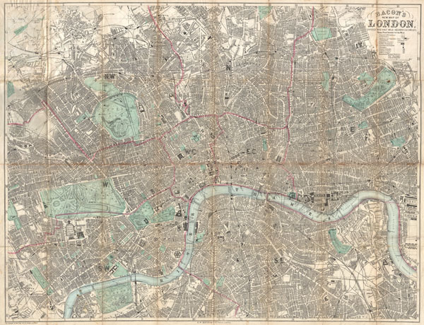
Bacon's New Map of London Divided into Half Mile Squares & Circles.
sold
- Digital Map Information
- Suitable for large format printing
- File Size: 40.27 MB
- File Type: ZIP / TIFF
- ICC color profile embedded
- Delivered instantly via download link
An extremely attractive c. 1890 traveler's pocket map of Victorian London, England. Covers central London on a scale of four inches to the mile - from West Kensington in the west across to the West India Docks in the ... (more details)
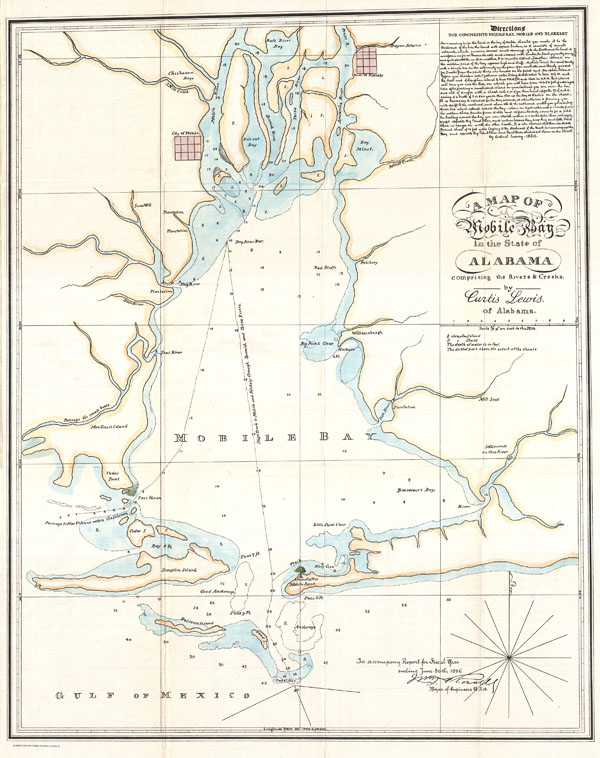
A Map of Mobile Bay in the State of Alabama comprising the Rivers & Creeks.
sold
- Digital Map Information
- Suitable for large format printing
- File Size: 6.63 MB
- File Type: ZIP / TIFF
- ICC color profile embedded
- Delivered instantly via download link
This is an unusual 1896 map or nautical chart of Mobile Bay, Alabama by Curtis Lewis. Originally drawn in 1820, this example is a reissue printed in 1896 for William Trent Rossell's congressional Report . This ... (more details)
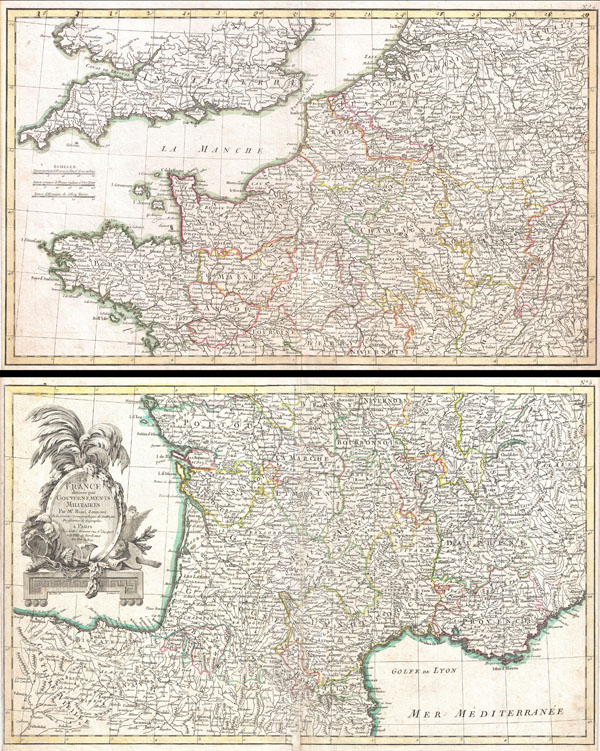
La France divisee par Gouvernements Militaires.
sold
- Digital Map Information
- Suitable for large format printing
- Full resolution TIFF file
- ICC color profile embedded
- Delivered instantly via download link
A beautiful example of Zannoni's 1775 decorative two panel map of France. Lower sheet covers from Valladolid, Spain, eastwards as far as Piedmont and northwards as far s Navernois. Northern sheet covers from ... (more details)

Carte du Gouvernement de Normandie avec celui du Maine et Perche.
sold
- Digital Map Information
- Suitable for large format printing
- DPI: 300
- File Size: 8.33 MB
- File Type: ZIP / TIFF
- ICC color profile embedded
- Delivered instantly via download link
A beautiful example of Rigobert Bonne's 1771 decorative map of Normandy, France. Covers from Bretagne eastward as far as Picardie. Includes the Channel Islands of Guernsey and Jersey. A decorative title ... (more details)
Johnson's first vertical plan of New York.

Johnson's New York and Brooklyn.
sold
- Digital Map Information
- Suitable for large format printing
- File Size: 16.88 MB
- File Type: ZIP / TIFF
- ICC color profile embedded
- Delivered instantly via download link
This is A. J. Johnson's attractive vertical plan of New York City. Depicts all of Manhattan, Brooklyn as it was at the time, and parts of Queens, Long Island City, Astoria, Jersey City and Hoboken. ... (more details)
A particularly beautiful example of this important nautical chart.
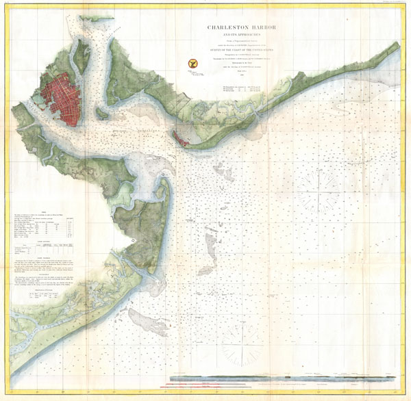
Charleston Harbor and its Approaches.
sold
- Digital Map Information
- Suitable for large format printing
- File Size: 22.48 MB
- File Type: ZIP / TIFF
- ICC color profile embedded
- Delivered instantly via download link
This is a highly desirable and uncommon 1866 U.S. Coast Survey chart or map of Charleston Harbor, South Carolina. Covers from Chareston south to Folly Island and east as far as Long island. Offers ... (more details)
A particularly beautiful example of this important nautical chart.
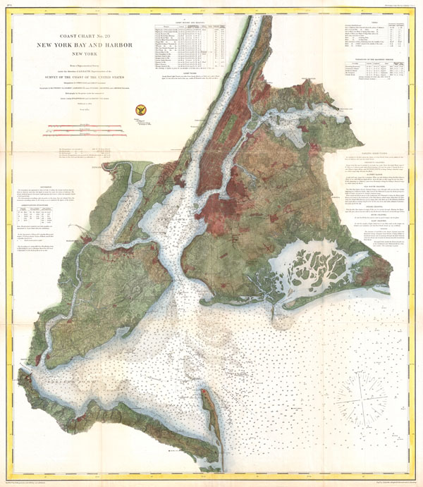
Coast Chart No. 20, New York Bay and Harbor, New York.
sold
- Digital Map Information
- Suitable for large format printing
- File Size: 27.64 MB
- File Type: ZIP / TIFF
- ICC color profile embedded
- Delivered instantly via download link
A rare 1866 coastal chart of New York City, it's harbor, and environs. One of the first 19th century carts to depicts New York City as we know it today, including Manhattan, Queens, Brooklyn, the ... (more details)
Details the historic 1860 expansion of Pars from 12 to 20 Arrondissements.
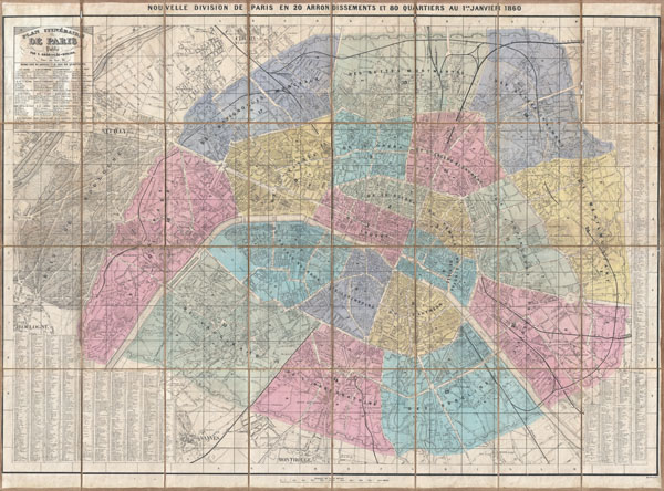
Plan Itineraire de Paris Publie. Nouvelle Division de Paris en 20 Arrondissements et 80 Quartiers au 1er. Janvier 1860.
sold
- Digital Map Information
- Suitable for large format printing
- File Size: 48.79 MB
- File Type: ZIP / TIFF
- ICC color profile embedded
- Delivered instantly via download link
This is an extremely attractive 1860 pocket plan or case map of Paris, France by the French map publisher Andriveau-Goujon. Covers central Paris as it appeared following the city's historic 1860 ... (more details)

Johnson's Map of New York and the Adjacent Cities.
sold
- Digital Map Information
- Suitable for large format printing
- File Size: 21.5 MB
- File Type: ZIP / TIFF
- ICC color profile embedded
- Delivered instantly via download link
A fine hand colored map of New York City and Brooklyn dating to 1865. Covers the island of Manhattan and the borough of Brooklyn as well as parts of Jersey City and Hoboken. Johnson's plan is ... (more details)