
Chinese propaganda broadside published at the height of the Cultural Revolution highlighting North Vietnamese victories during the American Vietnam War.

Map Battle Report. / 地图战报.
sold
- Digital Map Information
- Suitable for large format printing
- File Size: 4.49 MB
- File Type: ZIP / TIFF
- ICC color profile embedded
- Delivered instantly via download link
This is a September 1967 Chinese Map Battle Report propaganda broadside map of Vietnam published at the height of the Cultural Revolution. The map depicts the country of Vietnam from Laos and Cambodia to the Hainan and the South China Sea and from China to the Gulf of Thailand, with the map of Vietnam occupying nearly three-quarters of the broadside. Myriad villages are labeled throughout Vietnam and Laos, along with roads, rivers, and territorial borders. (more details)
Illustrates the theater of war and was created during the Russo-Turkish War of 1828 - 1829.

Map of the Country between Odessa, and Constantinople.
sold
- Digital Map Information
- Suitable for large format printing
- DPI: 300
- File Size: 20.06 MB
- File Type: ZIP / TIFF
- ICC color profile embedded
- Delivered instantly via download link
This is an 1828 James Wyld map of the Balkans and eastern Europe. The map depicts the region from the Gulf of Salonica and Transylvania to the Black Sea and from the Dniester River to the island of Lesbos (I. Mytilini). Beautifully engraved and highly detailed, Wyld most likely created this map as a response to interest in the Russo-Turkish War of 1828-29. Myriad cities, towns, and villages are labeled throughout, including Bucharest (Boukarest), Odessa, Salonica, and Istanbul / Constantinople. Rivers, such as the Danube and Dniester, are also illustrated, along with the region's topography and numerous islands in the Aegean Sea. Three different grades of road are also depicted, with the different symbols explained in a key situated in the upper-right corner. This detail helps illuminate the ease of travel and movement in general throughout the region. (more details)
A colorful and detailed city map of Bangkok published by the government railway department.

Plan of Bangkok.
sold
- Digital Map Information
- Suitable for large format printing
- File Size: 7.79 MB
- File Type: ZIP / TIFF
- ICC color profile embedded
- Delivered instantly via download link
This is a c. 1920 Thai issue Royal State Railway Department of Siam city map or plan of Bangkok, Thailand. The map depicts the city from the Bangkok Noi Station to the Royal Bangkok Sports Club and from Tejavanij Road to the Chao Phraya River. Created by the government railway department, four different railways are illustrated here. The Paknam Railway, Thailand's first railway, was established in 1893 and runs southeast from the main train station. The Northern and Eastern Railways run to the north from the same railway station, before the eastern line turns east. The Ta Chin Railway, today known as the Maeklong Railway, leaves the city from the Ta Chin Railway Station on the west side of the Chao Phraya and heads southwest. The Southern Railway leaves the city from Bangkok Noi Station on the west side of the river from the city center and heads due west. Numerous locations throughout the city are labeled, including the grand palace, the Pasteur Institue, Chulalongkorn University, and the Phyathai Palace. One hundred and three other locations are identified numerically and correspond with two different indexes included along the borders. The first, along the left border, lists these locations numerically, making it easier to find a location after locating a number on the map. The other index, split between the left and right borders, lists streets and klongs (waterways) alphabetically, and the numerically identified locations by category, such as banks, hotels, consulates and legations, post offices, and railway stations. (more details)
Remembered as one of the most lopsided battles of the war, Union forces suffered over three times the number of casualties as the Confederates during the Battle of Fredericksburg.

Fredericksburg.
sold
- Digital Map Information
- Suitable for large format printing
- File Size: 21.97 MB
- File Type: ZIP / TIFF
- ICC color profile embedded
- Delivered instantly via download link
This is an 1867 John Weyss and Nathaniel Michler map of the battlefield of Fredericksburg, Virginia. The map depicts the region from the Banks farmstead to the Fitzhugh farmstead and from the Jewett farmstead to the Massaponax River. Highly detailed, numerous homesteads, mills, farms, and churches are noted in the vicinity of the town of Fredericksburg. Fredericksburg itself is situated along the Rappahannock River and the town's street grid is illustrated. The Richmond, Fredericksburg, and Potomac Railroad traverses the map from north to south and crosses the Rappahannock at Fredericksburg. A canal to the northwest of Fredericksburg allows for an easier transit of the section of the Rappahannock around Beck's Island. The Old Richmond Stage Road, Orange Court House Turnpike, and Telegraph Road are illustrated as well. Although the actions of the battle are not explicitly traced, Confederate positions are illustrated in red, while a handful of Union forces are noted in blue. (more details)
The last victory for General Robert E. Lee and the Army of Northern Virginia during the American Civil War.

Cold Harbor.
sold
- Digital Map Information
- Suitable for large format printing
- File Size: 24.18 MB
- File Type: ZIP / TIFF
- ICC color profile embedded
- Delivered instantly via download link
This is an 1867 John Weyss and Nathaniel Michler map of the battlefield of Cold Harbor, Virginia. The map depicts the region from the Virginia Central Railroad to Emanuel Church and Black Creek Church and from the Linney Farm to the Taylor farm. The last battle of Union Lieutenant General Ulysses S. Grant's Overland Campaign, the Battle of Cold Harbor proved to be a lopsided victory for General Robert E. Lee and the Confederacy, but it would prove to be his last. Grant had achieved the goal of the Overland Campaign and had forced Lee into defending Richmond, the capital of the Confederacy, and Petersburg behind a network of trenches and other fortifications. Soon after the Battle of Cold Harbor began the Richmond-Petersburg Campaign, more popularly known as the Siege of Petersburg, a nine-month-long episode of trench warfare and small battles, that culminated in the capture of Petersburg and the evacuation of Richmond by the Confederate government. (more details)
A major Union campaign led by General Benjamin Butler undertaken (at the same time as Grant's Overland Campaign) that ended in stalemate.

Bermuda Hundred.
sold
- Digital Map Information
- Suitable for large format printing
- File Size: 23.62 MB
- File Type: ZIP / TIFF
- ICC color profile embedded
- Delivered instantly via download link
This is an 1867 John Weyss and Nathaniel Michler map of the Bermuda Hundred Campaign during the American Civil War. The map depicts the region from the Dunnson farm to the Jordan's Point Lighthouse on the James River and from Chaffin's Bluff and Drury's (Drewry's) Bluff to the J. Mason farm. (more details)
A detailed look at the Siege of Petersburg including the Battle of Five Forks, a key victory in forcing the surrender of the Army of Northern Virginia by Robert E. Lee.

Petersburg and Five Forks.
sold
- Digital Map Information
- Suitable for large format printing
- File Size: 29.42 MB
- File Type: ZIP / TIFF
- ICC color profile embedded
- Delivered instantly via download link
This is an 1867 John Weyss and Nathaniel Michler map of Petersburg and Five Forks, Virginia. The map depicts the region from Five Forks to Prince George Court House and from the river road north of the Appomattox River to Malone's Bridge on Rowanty Creek. (more details)
Illustrates in detail Richmond, the capital of the Confederacy, and its environs, along with Confederate and Union fortifications.

Richmond.
sold
- Digital Map Information
- Suitable for large format printing
- File Size: 27.02 MB
- File Type: ZIP / TIFF
- ICC color profile embedded
- Delivered instantly via download link
This is an 1867 John Weyss and Nathaniel Michler map of Richmond, Virginia, the Capital of the Confederacy, and its environs. The map depicts the region from the Western Plank Road to Hopewell Church and from Yellow Tavern to Willis Methodist Church. Highly detailed, both Confederate and Union fortifications are illustrated, with Confederate lines colored red and Union lines colored blue. The street grid of Richmond and Manchester are illustrated, and farms, mills, churches, and other landmarks are identified throughout. Several railroads, including the Richmond and Fredericksburg, the Richmond and Petersburg, and the Virginia Central are illustrated and labeled, as are the Mechanicsville Turnpike, the Williamsburg Turnpike, and the Brook Turnpike. Cold Harbor, Virginia, the site of the Battle of Cold Harbor, is located only ten miles northeast of Richmond, situating it, and the battle lines, in the upper right quadrant. (more details)
Illustrates the area southwest of Mexico City which is now the upscale neighborhood of Jardines del Pedregal.

Battles of Mexico, Line of Operations of the U.S. Army under the command of Major General Winfield Scott, on the 19th and 20th of August 1847.
sold
- Digital Map Information
- Suitable for large format printing
- DPI: 300
- File Size: 16.18 MB
- File Type: ZIP / TIFF
- ICC color profile embedded
- Delivered instantly via download link
This is an 1847 Edmund Hardcastle map of the Battle of Churubusco during the Mexican-American War. The map depicts a region southwest of Mexico City surrounding the lava fields of the Pedregal de San Àngel, today the fashionable upscale residential neighborhood of Jardines del Pedgregal. Several buildings and communities are illustrated around the Pedregal, including San Augustin, San Angel, San Antonio La Isla (San Antonio), and Churubusco. Individual buildings are depicted along many of the roads, though most are not labeled. (more details)
Charming pictorial map of Edinburgh that illustrates many sites across the city in profile.
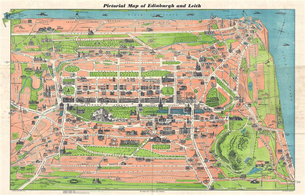
Pictorial Map of Edinburgh and Leith.
sold
- Digital Map Information
- Suitable for large format printing
- File Size: 19.66 MB
- File Type: ZIP / TIFF
- ICC color profile embedded
- Delivered instantly via download link
This is a c. 1950s Stanley Press pictorial city map or plan of Edinburgh, Scotland. The map depicts the city from the Forth Bridge to the Promenade along the Firth of Forth and from the Firth of Forth to the Royal Observatory and Craigmillar Castle. Wonderfully illustrated in the monumental style, monuments and other important sites throughout Edinburgh and Leith are drawn in profile. Some of the numerous buildings include Edinburgh Castle, the Royal Scottish Academy, the Royal Scottish Museum, and Calton Hill, along with many churches and colleges. Princes Street, one of the main thoroughfares in Edinburgh, is labeled, along with many others. Railways, tramways, and bus routes within the city are also depicted, allowing the tourist the opportunity to use the map to traverse the city and see all the important sites. (more details)
Illustrates the movements of General William J. Worth's division on August 20, 1847, during the Battle of Churubusco near the end of the Mexican-American War.
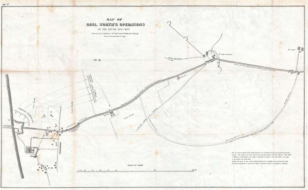
Map of Genl. Worth's Operations on the 20th of August, 1847.
sold
- Digital Map Information
- Suitable for large format printing
- DPI: 300
- File Size: 7.22 MB
- File Type: ZIP / TIFF
- ICC color profile embedded
- Delivered instantly via download link
This is an 1847 Edmund Hardcastle map of the actions of General William Jenkins Worth's division during the Battle of Churubusco which took place near the end of the Mexican-American War. Oriented towards the east, the map depicts the battlefield from the bridge ... (more details)
Highlights the highways, tramways, and bus routes of Memphis.
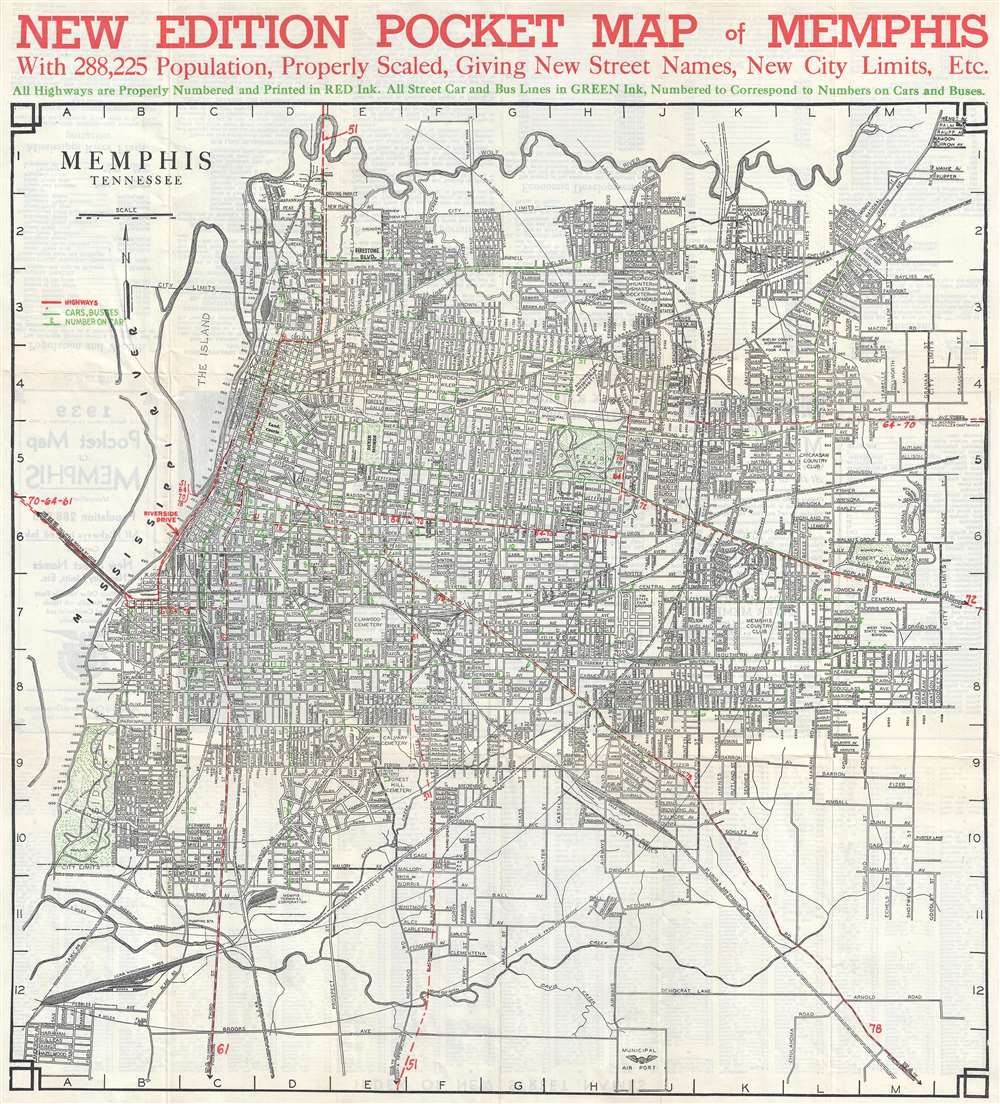
New Edition Pocket Map of Memphis.
sold
- Digital Map Information
- Suitable for large format printing
- File Size: 13.46 MB
- File Type: ZIP / TIFF
- ICC color profile embedded
- Delivered instantly via download link
This is a 1939 Memphis Chamber of Commerce city map or plan of Memphis, Tennessee. The map depicts the city from the Mississippi River to the City Limits and from Wolf River to the Municipal Airport. Highly detailed, myriad streets throughout the city are illustrated and labeled and a street index is provided on the verso. The most striking aspect is the use of colored lines to highlight the city's highways, tramways, and bus routes. Highways are marked by red dashed lines and are 'properly numbered' as all U.S. highways are numbered. Bus and tram lines are indicated by green dashed lines and are also labeled by number. Arrows appear on parts of these lines to indicate in which direction the bus or tram is traveling. (more details)
A controversial battle near San Diego, California fought during the Mexican-American War of which the victor is still debated.

Sketch of the Actions fought at San Pascal in Upper California between the Americans and Mexicans Dec. 6th and 7th, 1846.
sold
- Digital Map Information
- Suitable for large format printing
- DPI: 300
- File Size: 2.06 MB
- File Type: ZIP / TIFF
- ICC color profile embedded
- Delivered instantly via download link
This is an 1847 William Hemsley Emory map of the battle of San Pasqual during the Mexican-American War. Located in what is today the San Pasqual Valley area of the city of San Diego, California, the map depicts the actions of an American military force led by General Stephen Watts Kearny against a group of insurgents under the leadership of Andres Pico, the younger brother of Mexican Governor Pio Pico. Printed lines trace the actions of both Kearny and Pico's forces, illustrating (and labeling) rather well the progression of the engagement. Several positions are labeled and dated, allowing the viewer some understanding of how events unfolded. (more details)
Wonderful atlas map of Alaska soon after it was ceded to the United States by Russia.
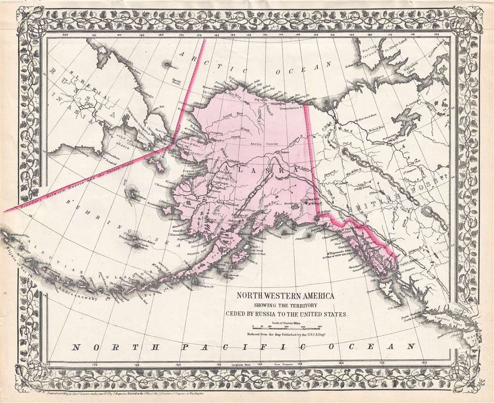
Northwesterb America Showing the Territory Ceded by Russia to the United States.
sold
- Digital Map Information
- Suitable for large format printing
- File Size: 4.32 MB
- File Type: ZIP / TIFF
- ICC color profile embedded
- Delivered instantly via download link
This is an 1872 Samuel Augustus Mitchell Jr. map of Alaska. The map depicts the entire state of Alaska, along with eastern Siberia across the Bering Strait from Alaska, western Canada, and the Pacific coast of North America as far south as Vancouver Island and ... (more details)
The only known example of Japan's second Serio-Comic map.
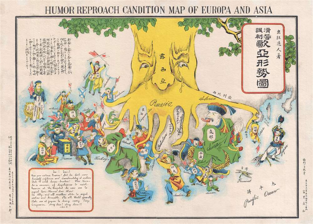
Humor Reproach Candition Map of Europa and Asia. / 滑稽諷刺歐亞形勢圖
sold
- Digital Map Information
- Suitable for large format printing
- File Size: 6.6 MB
- File Type: ZIP / TIFF
- ICC color profile embedded
- Delivered instantly via download link
A previously unknown Meiji 37 or 1904 Japanese broadsheet serio-comic map relating to the Russo-Japanese War. This map was issued in May 28 of 1904, immediately following Japan's successful siege and bombardment Russian held Port Arthur (Dalian). Of the four Japanese serio-comic maps associated with the Russo-Japanese war, this is the second, predated only by Kisaburō Ohara's April 1904 A Humorous Diplomatic Atlas of Europe and Asia. (more details)
The first battle of General Ulysses S. Grant's 1864 Overland Campaign against General Robert E. Lee's Army of Northern Virginia.
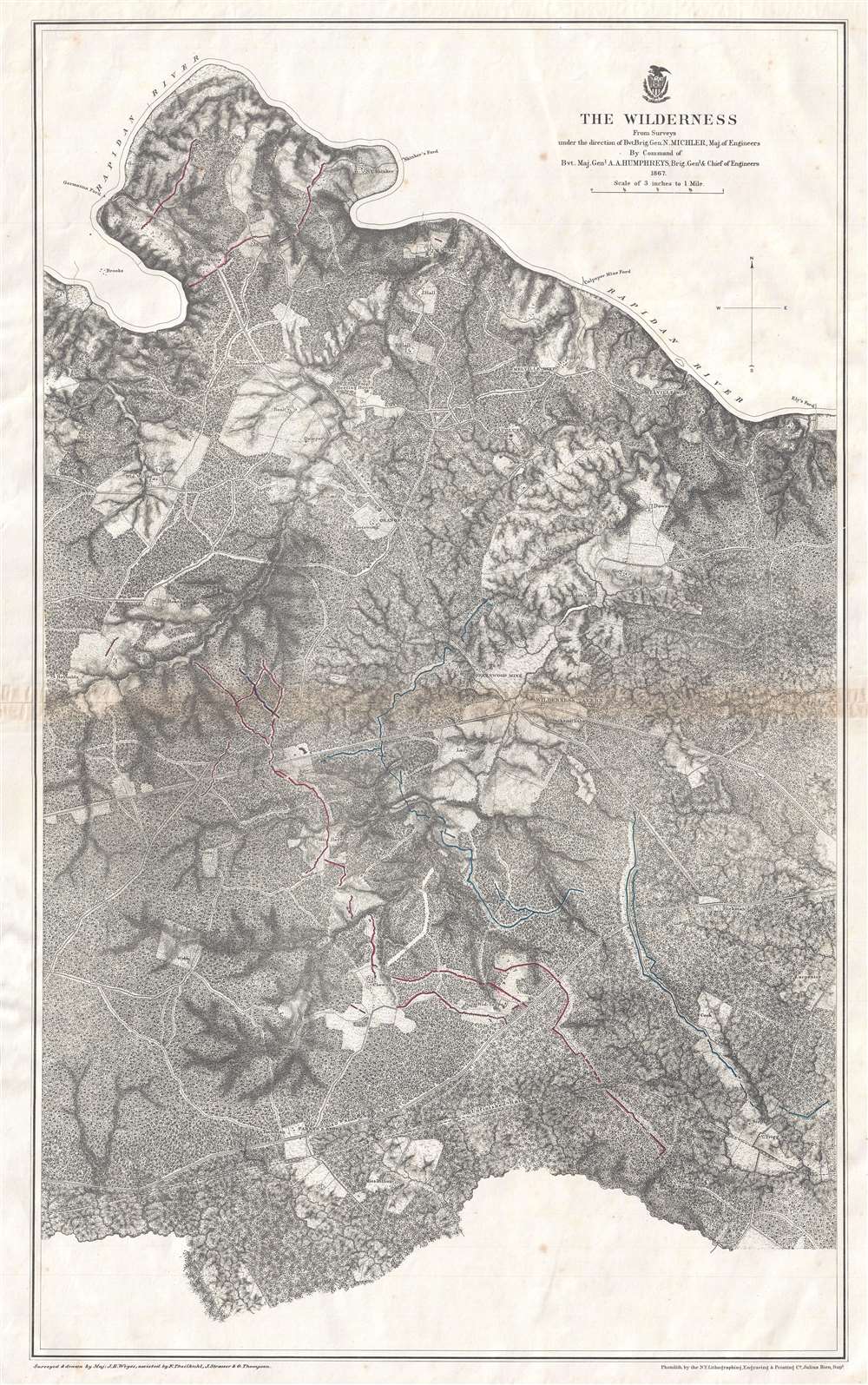
The Wilderness.
sold
- Digital Map Information
- Suitable for large format printing
- File Size: 22.36 MB
- File Type: ZIP / TIFF
- ICC color profile embedded
- Delivered instantly via download link
This is an 1867 John Weyss and Nathaniel Michler map of the battlefield of the Wilderness in Virginia. The map depicts the region from Brook's Ford on the Rapidan River to the Carpenter homestead and from Rapidan River to Miss Billion's homestead. The first battle in General Ulysses S. Grant's Overland Campaign against Robert E. Lee's Army of Northern Virginia, the Battle of the Wilderness ended in a strategic stalemate. Nonetheless, Grant was undeterred and did something no other Union commander had up to that point in the war: he continued on the offensive instead of retreating. By continuing his push deeper into Virginia, even though the Army of the Potomac had suffered catastrophic casualties, Grant won the admiration and support of his soldiers, as they were convinced that the commander of the Army of the Potomac would finally lead them to victory. (more details)
The second major engagement of General Grant's 1864 Overland Campaign.

Spottsylvania Court House.
sold
- Digital Map Information
- Suitable for large format printing
- File Size: 24.75 MB
- File Type: ZIP / TIFF
- ICC color profile embedded
- Delivered instantly via download link
This is an 1867 John Weyss and Nathaniel Michler map of the battlefield of Spotsylvania Court House in Virginia, the second battle in General Ulysses S. Grant's 1864 Overland Campaign in Virginia. The map depicts the region from Shady Grove Church to the Abbot homestead and from Piney Branch Church to the Crutchfield farm. (more details)
The third action in General Grant's 1864 Overland Campaign against General Robert E. Lee.

North Anna.
sold
- Digital Map Information
- Suitable for large format printing
- File Size: 11.88 MB
- File Type: ZIP / TIFF
- ICC color profile embedded
- Delivered instantly via download link
This is an 1867 John Weyss and Nathaniel Michler map of the battlefield of North Anna in Virginia, the third battle in General Ulysses S. Grant's 1864 Overland Campaign in Virginia. The map depicts the region from Noel's Station and the Little River to a race course near Major Dowlett's homestead and from Mt. Carmel Church to Hanover Junction. (more details)
Illustrates the Battle for Mexico City during the Mexican-American War.

Plan Accompanying Gen. Quitman's Report.
sold
- Digital Map Information
- Suitable for large format printing
- DPI: 300
- File Size: 4.32 MB
- File Type: ZIP / TIFF
- ICC color profile embedded
- Delivered instantly via download link
This is an 1847 map of The Battle of Chapultepec and the fall of Mexico City during the Mexican-American War. The map depicts the region from just west and southwest of Chapultepec Castle, which guards the western approaches of Mexico City to Mexico City ... (more details)
Map of Alaska from the year it was ceded by Russia to the United States.

North Western America, Showing the Territory Ceded by Russia to the United States.
sold
- Digital Map Information
- Suitable for large format printing
- File Size: 4.81 MB
- File Type: ZIP / TIFF
- ICC color profile embedded
- Delivered instantly via download link
This is a beautiful 1867 Samuel Augustus Mitchell Jr. map of Alaska. The map depicts the entire state of Alaska (which had only been ceded to the United States by Russia that year) along with eastern Siberia across the Bering Strait from Alaska, western ... (more details)