
Germany following the March Revolution.
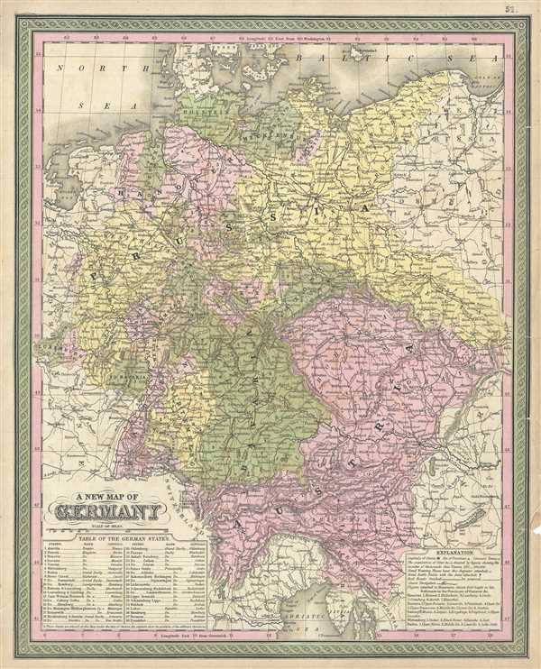
A New Map of Germany.
sold
- Digital Map Information
- Suitable for large format printing
- DPI: 300
- File Size: 9.88 MB
- File Type: ZIP / TIFF
- ICC color profile embedded
- Delivered instantly via download link
This is and attractive 1849 map by S. A. Mitchell's depicting greater Germany, inclusive of Austria, Bohemia, Prussia, Luxembourg, Bavaria, and parts of Poland. Political and topographical features are noted and color coded with elevation rendered by hachure. In ... (more details)
Holland and Belgium with Luxemburg as depicted by Mitchell.
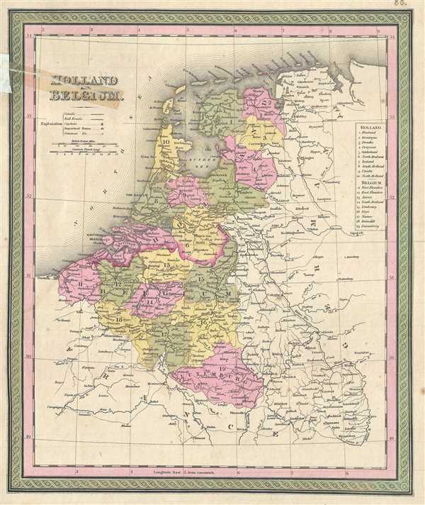
Holland and Belgium.
sold
- Digital Map Information
- Suitable for large format printing
- DPI: 300
- File Size: 4.77 MB
- File Type: ZIP / TIFF
- ICC color profile embedded
- Delivered instantly via download link
This is a lovely example of S. A. Mitchell Sr.'s 1849 map of Holland and Belgium. Depicts both countries color coded according to individual departments. Includes Luxembourg. Political and topographical features are noted and color coded with elevation rendered ... (more details)
Map of France with inset of Corsica.

France.
sold
- Digital Map Information
- Suitable for large format printing
- DPI: 300
- File Size: 10.04 MB
- File Type: ZIP / TIFF
- ICC color profile embedded
- Delivered instantly via download link
This is an attractive example of S. A. Mitchell's 1849 map of France. Each of France's 32 provinces are identified by number and associated with a table at the left border. Insets in the upper right and left quadrants focus on the environs of Paris and the ... (more details)
Mid 19th century map of the Emerald Isle.
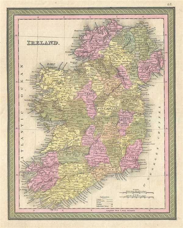
Ireland.
sold
- Digital Map Information
- Suitable for large format printing
- DPI: 300
- File Size: 5.7 MB
- File Type: ZIP / TIFF
- ICC color profile embedded
- Delivered instantly via download link
This hand colored map is a lithographic engraving of Ireland, dating to 1850, by the American map publisher S.A. Mitchell. Covers all of Ireland including Northern Ireland, and is divided into the traditional 32 counties. Topographical information is ... (more details)
Scotland according to Mitchell.

Scotland.
sold
- Digital Map Information
- Suitable for large format printing
- DPI: 300
- File Size: 5.96 MB
- File Type: ZIP / TIFF
- ICC color profile embedded
- Delivered instantly via download link
This is a fine example of and S. A. Mitchell's 1854 map of Scotland. It covers all of Scotland from the Orkney Islands to Wigton. An inset in the upper left quadrant depicts the Shetland Isles. Political and topographical features are noted and color ... (more details)
Mitchell's map of England and Wales.
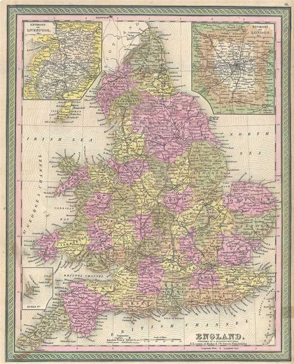
England.
sold
- Digital Map Information
- Suitable for large format printing
- DPI: 300
- File Size: 9.12 MB
- File Type: ZIP / TIFF
- ICC color profile embedded
- Delivered instantly via download link
This is an attractive example of S. A. Mitchell's 1849 map of England. It covers all of England from Northumberland in the north to Cornwall in the south. Two insets in the upper left and right quadrants depict the environs of Liverpool and London, ... (more details)
Mitchell's map of Venezuela, Colombia and Ecuador.

Venezuela, New Granada and Equador.
sold
- Digital Map Information
- Suitable for large format printing
- DPI: 300
- File Size: 8.81 MB
- File Type: ZIP / TIFF
- ICC color profile embedded
- Delivered instantly via download link
A fine example of S. A. Mitchell's 1849 map of Venezuela, Colombia (New Grenada) and Ecuador. Covers from the Bay of Panama to Brazil. Political and topographical features are noted and color coded with elevation rendered by hachure. The railroad ... (more details)
Extremely rare Japanese perspective satirical 'Octopus Map' of Asia.

A Humorous Diplomatic Atlas of Europe and Asia. / 滑稽欧亜外交地図 / Kokkei Ō-A Gaikō Chizu.
sold
- Digital Map Information
- Suitable for large format printing
- File Size: 13 MB
- File Type: ZIP / TIFF
- ICC color profile embedded
- Delivered instantly via download link
A wonderful example of the rare 1904 Kisaburō Ohara / Shingo Nakamura satirical 'Octopus Map' of Europe. Composed at the outbreak of the Russo-Japanese War (1904 - 1905), Ohara here follows the conventions established by J. J. van Brederode ( Humoristische-Oorlogskaart, 1870) and Fred Rose (Serio-Comic War Map, 1877). These two maps established the convention of satirizing Russian expansionism as a menacing Kraken-like 'Black Octopus.' Whereas Brederode and Rose confine their images to Russia, Ohara has here expanded the idea to encompass all of Eurasia. Russia's eight grasping tentacles extend across Europe and Asia; on many countries they already have a firm grip. Finland, Poland, Crimea, and the Balkan nations are represented as skulls, while tentacles grasp Turkey around the foot and waist, Persia about the neck, and Tibet by the arm. The Trans-Siberian Railway and the South Manchuria Railway, represented by the rightmost tentacle, had by this time extended Russian influence into Manchuria as far as the valuable ice-free Russian stronghold of Port Arthur. As this map was issued in March of 1904, the struggle between Russian and Japan over control of Port Arthur was ongoing. Port Arthur was surrendered to the Japanese, who defeated the Russian Fleet in December of 1905, several months after this map was printed. Ohara sums up the situation in his English language descriptions of the map, printed in the upper left,
Black Octopus is a name newly given to Russia by a certain prominent Englishman. For the black octopus is so avaricious, that he stretches out his eight arms in all directions, and seizes up every thing that comes within his reach. But as it sometimes happens he gets wounded seriously even by a small fish, owing to his too much covetousness. Indeed, a Japanese proverb says: 'Great avarice is like unselfishness.' We Japanese need not to say much on the cause of the present war. Suffice it to say that the further existence of the Black Octopus will depend entirely upon how he comes out of this war. The Japanese fleet has already practically annihilated Russia's naval powers in the Orient. The Japanese army is about to win a signal victory over Russia in Corea and Manchuria. And when ... St. Petersburg? Wait and see! The ugly Black Octopus! Hurrah! Hurrah! for Japan.Certainly the map had a strong message, but who saw it? (more details)
The earliest obtainable example of the first map to introduce four fictional islands in Lake Superior. Islands later used to draw the post-Revolutionary War US-Canada border.
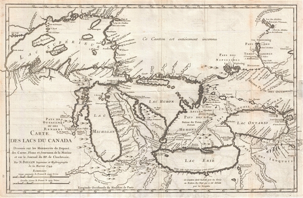
Carte des Lacs du Canada Dresse sur les Manuscrits du Depost des Carts, Plans et Journaux de la Marine et sur le Journal de RP. De Charlevoix.
sold
- Digital Map Information
- Suitable for large format printing
- DPI: 300
- File Size: 5.74 MB
- File Type: ZIP / TIFF
- ICC color profile embedded
- Delivered instantly via download link
An iconic and historically influential 1744 map of the Great Lakes by Jacques-Nicholas Bellin. Possibly Bellin's most important production, this is the earliest obtainable map, preceded only by a 1742 proof noted by Kershaw, to depict the four ... (more details)
Unusual World War II era scartchwork image by the known artist M. J. Kallem illustrating a skeletal Hitler figure consuming the world.

[Spectral Nazi Consuming World]
sold
- Digital Map Information
- Suitable for large format printing
- File Size: 16.01 MB
- File Type: ZIP / TIFF
- ICC color profile embedded
- Delivered instantly via download link
A striking c. 1940 image by the listed Russian-American Jewish portrait artist Morris J. Kallem. The image features a globe centered on the Pacific floating in space. Above it is a demonic skeletal figure with a Nazi swastika and Hitler-style ... (more details)
The earliest obtainable map of San Francisco Bay.
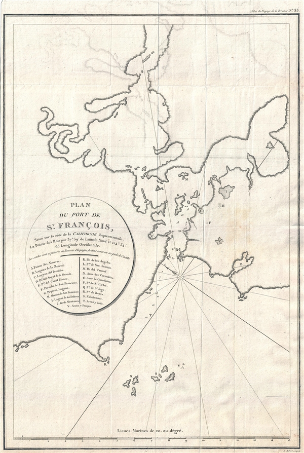
Plan du Port de St. Francois, situe sur la cote de la Californie Septentrionale. La Pointe des Rois par 37°59' de latitude nord et 124°54' de longitude occidentale.
sold
- Digital Map Information
- Suitable for large format printing
- Full resolution TIFF file
- ICC color profile embedded
- Delivered instantly via download link
A fine example of La Perouse's important 1797 map of San Francisco Bay. This is the earliest obtainable map of San Francisco Bay. The map may seem a little hard to decipher by modern standards. It is oriented to the Northeast, the peninsula ... (more details)
Rare view of Prague celebrating the 1926 8th Sokol Rally.

Praha v Době VIII. Sletu Všesokolského 1926. (Prague during the 8th Sokol Rally in 1926)
sold
- Digital Map Information
- Suitable for large format printing
- File Size: 23.09 MB
- File Type: ZIP / TIFF
- ICC color profile embedded
- Delivered instantly via download link
This is a scarce 1926 Joseph Ruep bird's-eye view of Prague (Praha), Czech Republic, intended to commutate the 8th Sokol Rally. The view presents Prague as seen from the high above Petřín Hill looking eastward over the Vltava River towards ... (more details)
One of the finest maps of Brooklyn to appear in the second half of the 19th century.

Map of the Consolidated City of Brooklyn.
sold
- Digital Map Information
- Suitable for large format printing
- File Size: 12.31 MB
- File Type: ZIP / TIFF
- ICC color profile embedded
- Delivered instantly via download link
An extremely attractive example of Henry McCloskey's 1865 pocket map of the city of Brooklyn, New York. Oriented to the East, this map covers from the Newtown Creek to Brooklyn's 59th Street and from East New York to the East River. In the ... (more details)
Wonderful pre-Rennell map of India.
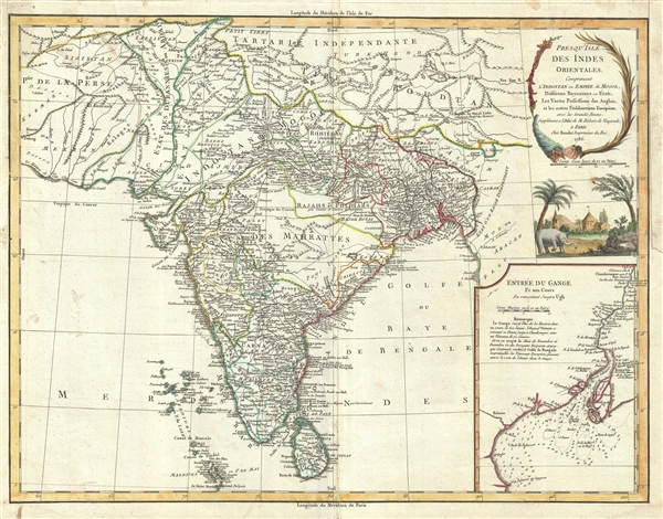
Presqu'Isle des Indes Orientales, Comprenant l'Indostan ou Empire du Mogol, Differens Royaumes ou Etats, Les Vastes Possessions des Anglais, et les autres Etablissemens EuropEens, avec les Grandes Routes.
sold
- Digital Map Information
- Suitable for large format printing
- DPI: 300
- File Size: 13.02 MB
- File Type: ZIP / TIFF
- ICC color profile embedded
- Delivered instantly via download link
This is a scarce and beautiful 1786 map of India and Sri Lanka by Robert de Vaugondy. It covers the Indian subcontinent from Independent Tartary south to include Ceylon and the Maldives and from Persia east as far as Aracan in the east. It ... (more details)
Scarce working nautical chart of Naragannsett Bay.

Cuttyhyunk to Block Island including Naragansett Bay.
sold
- Digital Map Information
- Suitable for large format printing
- File Size: 19.32 MB
- File Type: ZIP / TIFF
- ICC color profile embedded
- Delivered instantly via download link
An uncommon 1915 U.S. Coast and Geodetic Survey nautical chart or maritime map of Narragansett Bay, Rhode Island. The chart covers from Cuttyhunk to Block Island, including all of Narragansett Bay. The map is primarily coastal, but offers ... (more details)
Rare pictorial map of the 1933 Century of Progress Chicago World's Fair.

A Century of Progress, 1833-1933 : Chicago World's Fair Exposition. / The Midway of the Chicago World's Fair. / A Geographical Map of the Century of Progress Exposition Held in Chicago, Illinois 1933.
sold
- Digital Map Information
- Suitable for large format printing
- File Size: 30 MB
- File Type: ZIP / TIFF
- ICC color profile embedded
- Delivered instantly via download link
This is Tony Sarg's 1933 view and map of the 1933 Chicago Century of Progress World's Fair Exposition. The view is presented in two parts which were published, as here, side by side. The left side details the midway, the right side ... (more details)
Important early map illustrating the explorations of La Verendrye and the River of the West.
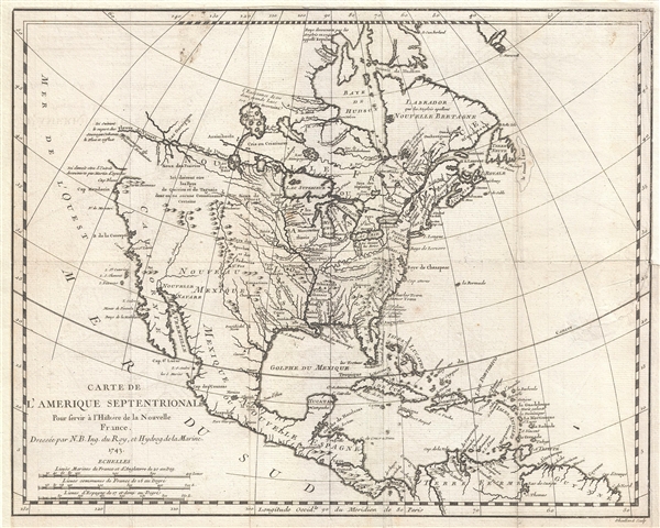
Carte de L'Amerique Septentrionale Pour servir a L'Histoire de la Nouvelle France.
sold
- Digital Map Information
- Suitable for large format printing
- Full resolution TIFF file
- ICC color profile embedded
- Delivered instantly via download link
An important and influential first edition first state 1743 map of the North America by the French cartographer Jacques-Nicholas Bellin. Bellin's map covers all of North America from the Arctic to the Spanish Main, including modern ... (more details)
Early mapping of Iowa.

Iowa.
sold
- Digital Map Information
- Suitable for large format printing
- DPI: 300
- File Size: 6.41 MB
- File Type: ZIP / TIFF
- ICC color profile embedded
- Delivered instantly via download link
This is a Samuel Augustus Mitchell’s 1849 map of Iowa. The map covers the eastern parts of modern day Iowa with county platting has been limited to the southeastern quadrants. The remainder of the state depicted is devoted to ... (more details)
Early uncommon mapping on Wisconsin by Mitchell.
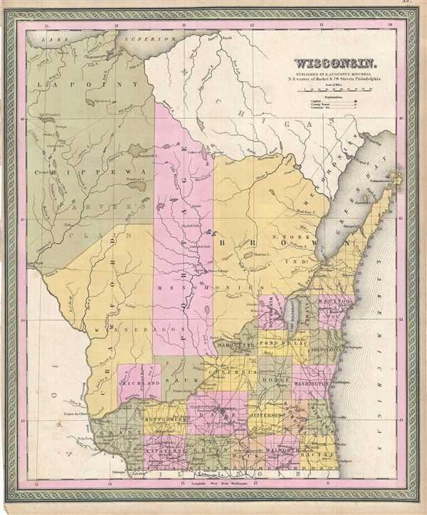
Wisconsin.
sold
- Digital Map Information
- Suitable for large format printing
- DPI: 300
- File Size: 7.28 MB
- File Type: ZIP / TIFF
- ICC color profile embedded
- Delivered instantly via download link
This is a beautiful example of Samuel A. Mithcell’s 1849 map of Wisconsin. The map covers the early county borders of the state and notes towns, cities, rivers, roads, and other topographical features. The whole is engraved ... (more details)
Mid 19th century map of Illinois showing lead regions.

A New Map of Illinois with its Proposed Canals, Roads & Distances from Place to Place along the Stage & Steam Boat Routes.
sold
- Digital Map Information
- Suitable for large format printing
- DPI: 300
- File Size: 6.98 MB
- File Type: ZIP / TIFF
- ICC color profile embedded
- Delivered instantly via download link
This is an uncommon 1849 map of Illinois by Samuel Augustus Mitchell. It covers the state of Illinois with exceptional detail, noting canals, railroads, steam boat routes, towns, rivers, roads and other topographical ... (more details)