
Illustrates the 'The Romantic Rhine' including the Rhine Gorge.
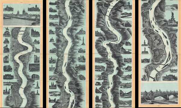
Neuestes Rhein-Panorama von Mainz bis Koeln.
sold
- Digital Map Information
- Suitable for large format printing
- Full resolution TIFF file
- ICC color profile embedded
- Delivered instantly via download link
This is an attractive c.1890 panoramic view or map of the Middle Rhine River in Germany issued by Gerhard Blumlein and Co. The birds eye view or map follows the Rhine River from Mainz to Cologne, with pictorial descriptions of various landmarks, monuments, ruins, ... (more details)
A highly desirous state of Johnson's popular southwest map.

Johnson's California, with territories of Utah, Nevada, Colorado, New Mexico, and Arizona.
sold
- Digital Map Information
- Suitable for large format printing
- Full resolution TIFF file
- ICC color profile embedded
- Delivered instantly via download link
One of the scarcest and most historically significant of Johnson and Ward’s southwest series. Published in 1866 at the height of the American Civil War, this stunning map depicts the state of California and the territories of Nevada, Utah, Colorado, New Mexico ... (more details)
Johnson's map predating Italy's unification.

Johnson's Italy.
sold
- Digital Map Information
- Suitable for large format printing
- Full resolution TIFF file
- ICC color profile embedded
- Delivered instantly via download link
A beautiful example of Johnson and Ward's 1866 map of Italy. Johnson first introduced this map in his 1863 atlas and it represents a substantial re-engraving of his original two-part plate. Throughout, Johnson identifies various cities, towns, rivers and ... (more details)
Johnson's hand colored map of New York City and Brooklyn.

Johnson's Map of New York and the Adjacent Cities.
sold
- Digital Map Information
- Suitable for large format printing
- Full resolution TIFF file
- ICC color profile embedded
- Delivered instantly via download link
A fine hand colored map of New York City and Brooklyn dating to 1866 by Johnson and Ward. Covers the island of Manhattan and the borough of Brooklyn as well as parts of Jersey City and Hoboken. Johnson's plan is heavily based upon the third state of J. ... (more details)
Early map of Virginia, West Virginia, Maryland and Delaware.

Johnson's Virginia Delaware and Maryland.
sold
- Digital Map Information
- Suitable for large format printing
- Full resolution TIFF file
- ICC color profile embedded
- Delivered instantly via download link
This is a beautiful example of Johnson and Ward’s 1866 map of Virginia, West Virginia, Maryland and Delaware. It offers a fascinating snapshot of these secessionist states shortly following the close of the American Civil War. The map shows all four ... (more details)
The most decorative editions of Johnson's Maryland-Delaware series.

Johnson's Delaware and Maryland.
sold
- Digital Map Information
- Suitable for large format printing
- Full resolution TIFF file
- ICC color profile embedded
- Delivered instantly via download link
This is a fine Johnson and Ward map of Maryland and Delaware dating to 1866. It covers both states as well as the capital district in considerable detail. This is the most decorative of Johnson’s Maryland-Delaware series with engraved views along ... (more details)
Johnson's map predating the splitting of the Dakotas.

Johnson's Minnesota and Dakota.
sold
- Digital Map Information
- Suitable for large format printing
- Full resolution TIFF file
- ICC color profile embedded
- Delivered instantly via download link
This is a beautiful example of Johnson and Ward’s 1866 map of Minnesota and Dakota. It covers both states as well as parts of adjacent Wisconsin and Iowa. This map predates the splitting of the Dakotas and instead depicts them as a single great ... (more details)
Johnson's map depicting the newly formed Idaho Territory, predating the exploration of the Yellowstone Valley.

Johnson's Washington Oregon and Idaho.
sold
- Digital Map Information
- Suitable for large format printing
- Full resolution TIFF file
- ICC color profile embedded
- Delivered instantly via download link
This is Johnson and Ward’s beautifully hand colored 1866 map of Washington, Oregon and Idaho, with parts of modern day Montana and Wyoming. This map shows cities, topographical features, railways, ferries and roads with color coding at the ... (more details)
Johnson's map of India and Southeast Asia.

Johnson's Hindostan or British India.
sold
- Digital Map Information
- Suitable for large format printing
- Full resolution TIFF file
- ICC color profile embedded
- Delivered instantly via download link
This is a nice example of Johnson and Ward’s 1866 map of India and Southeast Asia. It covers from the Indus River eastward to include all of India, Burma (Myanmar), Siam (Thailand), Laos, Cambodia, Malaysia (Malacca), Singapore and ... (more details)
Johnson's map depicting the newly formed Idaho Territory, predating the formation of Montana and Wyoming.

Johnson's Nebraska Dakota, Colorado Idaho and Kansas.
sold
- Digital Map Information
- Suitable for large format printing
- Full resolution TIFF file
- ICC color profile embedded
- Delivered instantly via download link
This is Johnson and Ward’s beautifully hand colored 1866 map of the territories of Idaho, Nebraska, Colorado and Kansas. Depicts what today consists of the states of Idaho, Wyoming, Colorado, Montana, North Dakota, South Dakota, ... (more details)
Beautiful 18th century map of Central Italy.

Etat de l'Eglise, Grand Duche de Toscane, et Isle de Corse.
sold
- Digital Map Information
- Suitable for large format printing
- Full resolution TIFF file
- ICC color profile embedded
- Delivered instantly via download link
This is an attractive 1750 map by Robert de Vaugondy depicting central Italy and regions of Tuscany, the Papal States and the Island of Corsica. It covers from Ferrara and Parma south to Terracina. Several important towns, ... (more details)
Map of Mount Desert Island and the Coast of Maine, home of the Acadia National Park.
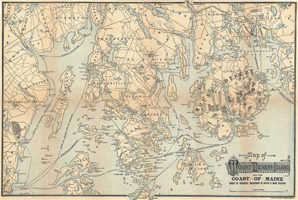
Map of Mount Desert Island and the Coast of Maine.
sold
- Digital Map Information
- Suitable for large format printing
- Full resolution TIFF file
- ICC color profile embedded
- Delivered instantly via download link
This is an attractive c.1890 map of Mount Desert Island and the coast of Maine issued by the Passenger Department of Boston and Maine Railroad. It covers Mount Desert Island and vicinity from Lincolnville and Rockland east ... (more details)
Large map of the San Francisco Bay Area.

Rand McNally Map of San Francisco Bay District.
sold
- Digital Map Information
- Suitable for large format printing
- File Size: 373.98 MB
- File Type: ZIP / TIFF
- ICC color profile embedded
- Delivered instantly via download link
This is a scarce c. 1928 map of the San Francisco Bay area by Rand McNally and Company. It covers from Petaluma south to San Jose and east as far as Sherman Island. The map is highly detailed, noting railroads, electric ... (more details)
Beautiful pictorial map depicting downtown Chicago, the Loop District and the Magnificent Mile.
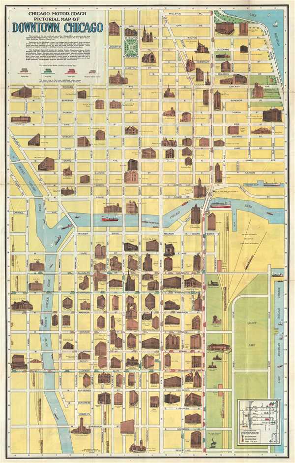
Chicago Motor Coach Pictorial Map of Downtown Chicago.
sold
- Digital Map Information
- Suitable for large format printing
- Full resolution TIFF file
- ICC color profile embedded
- Delivered instantly via download link
This is an attractive c.1940 map or plan of Chicago, Illinois issued by The Clason Map Co., Illinois. It covers from Harrison Street north to Bellevue Place and west as far as Canal St., depicting downtown Chicago, ... (more details)
Charming pictorial map of London intended for use by children.
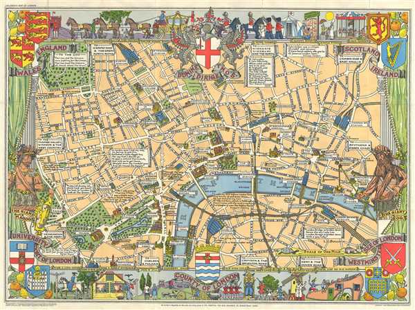
Children's Map of London.
sold
- Digital Map Information
- Suitable for large format printing
- Full resolution TIFF file
- ICC color profile embedded
- Delivered instantly via download link
A colorful and attractive c. 1955 pictorial map of London printed by John Bartholomew & Sons. The map covers central London from Hyde Park to Aldgate and from Green Park to Waterloo Station. Issued to raise funds ... (more details)
Bird's Eye View of Nantasket Beach from Boston.

Boston to Nantasket and Plymouth.
sold
- Digital Map Information
- Suitable for large format printing
- Full resolution TIFF file
- ICC color profile embedded
- Delivered instantly via download link
This is an uncommon c. 1915 bird’s eye-view of Nantasket and Plymouth issued by the Nantasket Beach Steamboat Company. Captures the view of the Nantasket Beach as far as Plymouth, as seen from Boston. The ... (more details)
Beautiful panorama of the Niagara Falls.
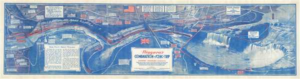
Niagara's Combination Scenic Trip.
sold
- Digital Map Information
- Suitable for large format printing
- Full resolution TIFF file
- ICC color profile embedded
- Delivered instantly via download link
This is an attractive 1934 panorama of the Niagara Falls by the Wilfred Davison. This bird’s eye view style map depicts the Niagara Gorge and the Great Gorge Route or the Niagara Belt Line. Along the way, ... (more details)
Stunning panoramic view of the Niagara Falls and the Great Gorge Route.

Niagara's Great Gorge Trip The Falls and Whirlpool Rapids Route.
sold
- Digital Map Information
- Suitable for large format printing
- Full resolution TIFF file
- ICC color profile embedded
- Delivered instantly via download link
This is a beautiful 1930 panorama of the Niagara Falls by the Whitney Graham Company. This bird’s eye view style map depicts the Niagara Gorge and the Great Gorge Route or the Niagara Belt Line. Along the ... (more details)
Pocket map of Pennsylvania.

Pennsylvania.
sold
- Digital Map Information
- Suitable for large format printing
- Full resolution TIFF file
- ICC color profile embedded
- Delivered instantly via download link
This is a c.1890 pocket map of Pennsylvania issued by J. L. Smith. It covers the state of Pennsylvania in its entirely, noting rivers, roads, railways, canals, towns, cities and other topographical ... (more details)
This is one of best early large maps of the United States and the premier map for its period.' - David Rumsey
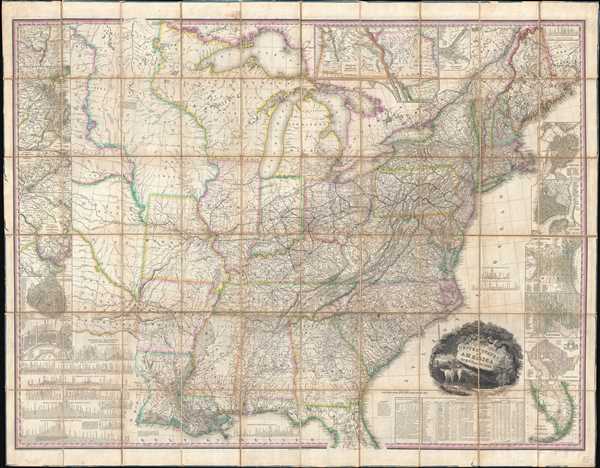
United States of America.
sold
- Digital Map Information
- Suitable for large format printing
- Full resolution TIFF file
- ICC color profile embedded
- Delivered instantly via download link
This, the first edition of Henry Schenck Tanner's 1829 wall map of the United States, is one of the most important American maps of the 19th century. The map covers from the Missouri river in the ... (more details)