
1850 / 1860 Manuscript Map of Saigon on back of rare Shanghai Chart

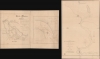
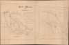
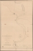
Carte de la Rivière de Saigon (Cochinchine). / Plan du Band de Corail (rivière de Saigon). / Plan de al Rivière de Woosung Levé en 1842 Par les Capitaines H. Kellet and R. Collinson, de la Marine Anglaise.
两个极其罕见的景点——西贡和上海——接连出现。
- Digital Map Information
- Suitable for large format printing
- Full resolution TIFF file
- ICC color profile embedded
- Delivered instantly via download link
两个极其罕见的景点——西贡和上海——接连出现。
这是一套非凡的双面地图——两幅地图各有其重要意义。其中最引人注目的是一幅约1860年绘制的精美手稿海图,详细描绘了通往西贡(胡志明市)的河流航道。其背面(或正面,视情况而定)是一幅1850年印刷的上海航海图,该图基于第一次鸦片战争(1839-1842)的地图绘制。两幅地图都意义非凡,但手稿海图更为重要,因为它极有可能是宋西贡河口最早的现代水文测量记录。西贡手稿地图
这幅精美的手稿地图详细描绘了中国海与西贡之间错综复杂的水道网络,很可能是最早的此类水域水文勘测记录。它源于19世纪60年代初法国为夺取和发展西贡,将其打造为重要港口而进行的一系列努力。地图上以米为单位标注了最重要的航道,并进一步标明了防御工事、村庄、著名树木等。地图中心突出了一片大型珊瑚礁——珊瑚礁滩(Banc de Corail),右侧的大幅细节图也对其进行了细致的描绘。这片珊瑚礁滩位于西贡主要航道之一的中心位置,对进出该市的船只构成了重大威胁,时至今日,它仍然是航行的一大隐患。这份手稿没有标注日期,但几乎可以肯定它出自1859-1860年左右法国占领西贡时期。我们发现了一份类似的印刷版海图,由莱奥·德·莱斯佩斯(Léo de Lespès)于1863年左右出版,其内容基于这份手稿,并进行了一些更新。两份海图的覆盖范围相同,但后者印刷版海图的修订细节比这份手稿更为详尽。两份海图都包含一幅比例尺较大的危险海域“珊瑚礁”(Banc de Corail)的地图。
这两幅手稿地图(西贡地图和珊瑚滩地图)均有A. Deschamps的签名。遗憾的是,我们未能找到更多关于这位行踪神秘的制图师的信息。
上海地图
印刷版的上海地图/海图本身就非常罕见。虽然它是由法国海军总局于 1850 年出版的,但它代表的是英国在第一次鸦片战争(1839-1842 年)期间占领上海时,由亨利·凯利特(1806-1875 年)和理查德·科林森(1811-1883 年)两位指挥官所做的勘测。深入了解上海
地图比例尺为1:28610,覆盖范围从长江与黄浦江(又称禹棹江)交汇处向南沿黄浦江延伸至上海古城(又称上海)。地图上标注了黄浦江沿岸的众多水深测量点,但除此之外,内陆地区的细节信息却很少。在大致呈圆形的城墙环绕的旧上海城周围,地图上标注了一些港口发展以及附近道路的建设。然而,该地图的绘制时间总体上早于上海在通商口岸时期的快速发展。再往北,地图上标出了数座保卫河流的堡垒,包括包山城和禹棹渔港。出版历史和人口普查
我们目前尚未发现其他西贡手稿地图或印刷版航海图的实物。我们注意到,上海地图的手稿原件现藏于法国国家图书馆,但未发现其他已知的印刷版。相反,我们已知有一幅与此相关的宋西贡河口印刷地图,但作为手稿,它是独一无二的。Cartographers
Dépôt des Cartes et Plans de la Marine (fl. 1720 - present), often called the Dépôt Général de la Marine, was a French hydrographic mapping organization founded in 1720 under Charles-Hercule of Albert de Luynes (1674 - 1734). Much like the U.S. Coast Survey, the British Admiralty, and the Spanish Deposito Hydrografico, the Dépôt was initiated as a storehouse and distribution center of existing nautical and marine charts. Eventually the Dépôt initiated its own mapping activities in an attempt to improve and expand upon existing material. Some of the more prominent cartographers and hydrographers associated with the of Dépôt Générale des Cartes were, Philippe Buache, Jacques-Nicholas Bellin, Giovanni Rizzi-Zannoni, Rigobert Bonne, and Jean Nicolas Buache. Further Details...
Richard Collinson (November 7, 1811 – September 13, 1883) was an English naval officer, marine surveyor, and Arctic explorer. He was born in Gateshead, Tyne and Wear, England, then part of Durham. He joined the Royal Navy in 1823, at age twelve, and rose in the ranks, becoming a lieutenant in 1835, commander in 1841, and captain in 1842. Collinson was a highly capable captain. He participated with distinction in the First Opium War (1839 - 1842). After the war, along with Commander Henry Kellett, he completed a series of pioneering surveys of the China coast from the Yangtze River to Hong Kong. These he completed between 1842 and 1846 while serving as commander of the HMS Plover. In 1850, he was sent north in command of the HMS Enterprise to search for survivors of the Sir John Franklin expedition. Although he came quite close, he never found Franklin's lost men and returned to England without success. Nonetheless, he was honored by the Royal Geographical Society for his surveys in the Arctic and proof that it was navigable from the Behring Strait to King William's Land. Collinson was Knighted in 1875, the same year in which he retired from active duty with the rand of Admiral. Collinson died in September of 1883. Further Details...
Henry Kellett (November 2, 1806 - March 1, 1875) was a Irish / British naval officer and hydrographer active in the mid-19th century. Kellett was born in Tipperary County, Ireland. He joined the Royal Navy in 1822. He afterwards spent three years in the West Indies. He was transferred to survey duty in Africa under William Fitzwilliam Owen (1774 - 1867). Just before the First Opium War (1839 - 1842) he was reassigned to China as the second-in-command of HMS Sulphur under Edward Belcher (1799 - 1877), famous for producing the first survey of Hong Kong Island. During the Opium War he was assigned his own ship, the HMS Starling and promoted first to commander (1841), then to post-captain (1842). In 1845 Kellett was appointed captain of the survey ship HMS Herald tasked to map the Americas from Guayaquil to Vancouver, including the Galápagos. In 1848, he joined the search for Sir John Franklin (1786 - 1847). During this voyage he sailed through the Bering Strait across the Chukchi Sea and discovered Herald Island. Later, Kellett became Senior Officer in the West Indies in 1855 and superintended Jamaica Dockyard. He served as Admiral Superintendent of the Malta Dockyard in 1864 and Commander-in-Chief, China Station in 1869. He retired in 1871 at the rank of Vice Admiral. Further Details...
Condition
Good. Partial centerfold split. Some ink burn through. Even toning. Edge wear.
References
cf. (Shanghai) Bibliothèque nationale de France, département Cartes et plans, GE SH 19 PF 179 DIV 18 P 21. cf. (Saigon) Bibliothèque nationale de France, département Cartes et plans, GE B-902.