
American Automobile Association (sold) (AAA)

The American Automobile Association (March 4, 1902 - present), better known as AAA ('Triple-A'), is a federations of motor clubs throughout America. A privately held national member association, AAA boasts over 58 million member in the United States and Canada. Founded on March 4, 1902 in Chicago, Illinois, AAA was originally created in response to a lack of roads and highways that were suitable for cars by nine individual motor clubs, including the Chicago Automobile Club, Automobile Club of America, and Automobile Club of New Jersey. AAA began publishing road maps in 1905 and hotel guides in 1917.
AKA: AAA
An early map of the Lincoln Highway - the first transcontinental highway in the United States.
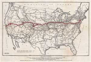
The Lincoln Highway.
sold
- Digital Map Information
- Suitable for large format printing
- File Size: 4.67 MB
- File Type: ZIP / TIFF
- ICC color profile embedded
- Delivered instantly via download link
This is a 1913 Lincoln Highway Association and American Automobile Association map of the proposed route for the Lincoln Highway, what would become the first transcontinental automobile road and the first national memorial to Abraham Lincoln. The map depicts the continental United States from the Pacific Ocean to the Atlantic Ocean and from Canada to Mexico. Highlighted in red and marked by diagonal lines, the original route for the Lincoln Highway stretches from New York to San Francisco and includes the 'Colorado Loop' that was removed from the route a few years later. Numerous other highways are illustrated, and those that are believed to be 'natural tributaries' are indicated by parallel lines drawn through those highways. Myriad cities, towns, and villages are labeled from coast to coast, as are major rivers, lakes, and mountain ranges. (more details)
Rare persuasive map made to promote the constrution of the U.S. Highway System!
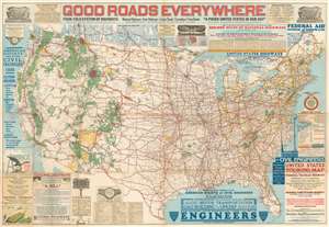
Good Roads Everywhere.
sold
- Digital Map Information
- Suitable for large format printing
- File Size: 98.5 MB
- File Type: ZIP / TIFF
- ICC color profile embedded
- Delivered instantly via download link
A scarce, large, and strikingly dense 1926 persuasive map of the United States prepared to promote federal investment in a national highway system. The map covers the United States from Coast to Coast and from Canada to Mexico. Highways are illustrated with color coding defining the 250,000 miles of national highways advocated for by the National Highway Association. These include the NHA's darling project, the National Park-to-Park Highway connecting the National Parks in the western United States. The map also includes arguments for the construction of 'Highway Airports.' (more details)
Highlights transcontinental roads leading to Yellowstone National Park.
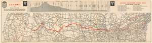
Atlantic Yellowstone Pacific Hiway
sold
- Digital Map Information
- Suitable for large format printing
- File Size: 16.02 MB
- File Type: ZIP / TIFF
- ICC color profile embedded
- Delivered instantly via download link
This is a c. 1927 American Automobile Association map of the Atlantic Yellowstone Pacific Highway. The map depicts the United States from the Pacific Ocean to the Atlantic Ocean and from Montana and Duluth, Minnesota to Norfolk, Virginia and Carson City, Nevada. The Atlantic Yellowstone Pacific Highway is highlighted in red, with the route from Chicago, Illinois to Twin Falls, Idaho marked in bold. Myriad cities and towns throughout the U.S. are labeled, with state capitals marked by star inscribed in a circle. Other highways across the country are illustrated as well, with different markings used to denote differing road grades. National parks, mountain ranges, lakes, and rivers are noted as well. A chart tracing the elevation of the highway from Chicago to Twin Falls is situated along the top border and highlights the increase in elevation, with the highest point along the route at th4e summit of the Togwotee Pass. (more details)
Ontario to Key West - 99 7/10% Paved!
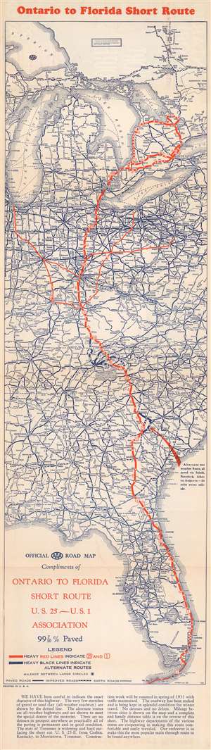
Ontario to Florida Short Route. U.S. 25 - U.S. 1 Association.
sold
- Digital Map Information
- Suitable for large format printing
- Full resolution TIFF file
- ICC color profile embedded
- Delivered instantly via download link
This is a 1930 AAA and 'Ontario to Florida Short Route U.S. 25 - U.S. 1 Association' road map of the central United States. Coverage extends from Cochrane, Ontario, south to Key West, Florida. 'Heavy red lines' indicate U.S. Highways 25 and 1. Cities and towns are identified and distances between major stops are provided. Thinner red lines trace connecting routes from Cleveland, Chicago, Indianapolis, and Louisville. The dashed red line in Canada indicates the forty-four miles of unpaved road between Owen Sound, Ontario, and the US Border. 'Heavy black lines indicate alternative routes', while thinner lines detail the general road network. Information concerning the route, including touristic stopovers, is printed on the verso. (more details)
Vignettes of Florida's tourist attractions.
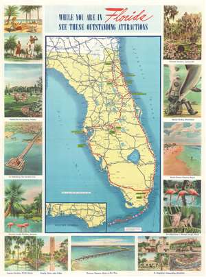
When You are in Florida See These Outstanding Attractions.
sold
- Digital Map Information
- Suitable for large format printing
- File Size: 35.55 MB
- File Type: ZIP / TIFF
- ICC color profile embedded
- Delivered instantly via download link
This is a 1941 American Automobile Association pictorial road map of Florida. (more details)
Features illustrations of ephemeral tourist attractions, such as Marine Studios and Clyde Beatty's Jungle Zoo.
While You Are In Florida See These Outstanding Attractions.
sold
- Digital Map Information
- Suitable for large format printing
- Full resolution TIFF file
- ICC color profile embedded
- Delivered instantly via download link
This is a c. 1942 American Automobile Association pictorial tourist road map of Florida. Appealing vignettes and other illustrations beckon tourists to visit Florida and explore all it offers. (more details)
Features illustrations of ephemeral tourist attractions, such as Marine Studios and Clyde Beatty's Jungle Zoo.
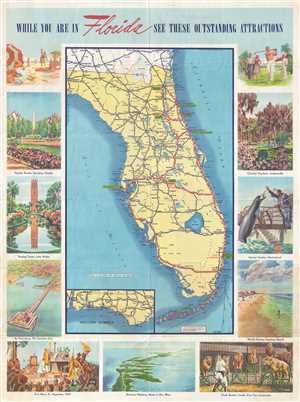
While You Are In Florida See These Outstanding Attractions.
sold
- Digital Map Information
- Suitable for large format printing
- File Size: 13.95 MB
- File Type: ZIP / TIFF
- ICC color profile embedded
- Delivered instantly via download link
This is a c. 1942 American Automobile Association pictorial road map of Florida. The map depicts the state from Tallahassee and the Gulf of Mexico to the Atlantic Ocean and from Georgia to Key West. Cities and towns throughout the state are labeled, as are major ... (more details)
Cruising through the Keys.
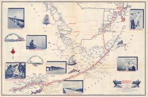
Miami to Key West via Overseas highway.
sold
- Digital Map Information
- Suitable for large format printing
- Full resolution TIFF file
- ICC color profile embedded
- Delivered instantly via download link
A charming 1950 American Automobile Association (AAA) map of Southern Florida highlighting the Overseas Highway (U.S. 1) running through the Florida Keys. Adorned with photographs and illustrations, it combines function and aesthetics, and highlights fishing in the region, one of the region's main attractions for tourists and residents alike. (more details)
Drive Highway 1 in Florida and enjoy the sunshine!
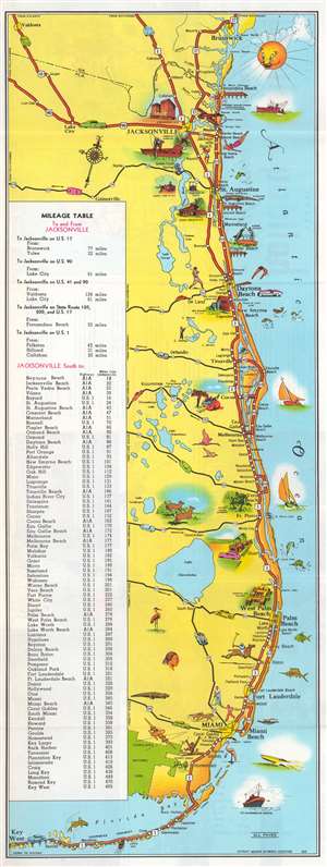
This is a charming c. 1954 American Automobile Association (AAA) pictorial tourist map of Florida. Depicting from Brunswick, Georgia, south along the Atlantic Coast to Miami and continuing to Key West, the map highlights the storied U.S. Highway 1 and several connecting highways along the coast. Pictorial vignettes highlight popular activities, like swimming, deep sea fishing, and golfing. Tourist attractions (many now defunct) like Marineland, the Norton Art Gallery, and Monkey Village are also highlighted. The recently established Everglades National Park extends the map's coverage and is emphasized in verdant green. An index of distances from Jacksonville occupies the left third of the map. (more details)
Visit wonderful Silver Springs, Florida!
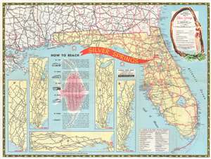
This is a 1955 Automobile Association of America map of Florida. Created as a promotional for Silver Springs, a tourist destination outside Ocala, Florida, a large red 'arrow' points the way. U.S. highways are illustrated in red. Four highways pass through Ocala, highlighting the destination's easy access. Five inset maps, each focused on a different part of the United States, trace highway routes from numerous major cities in the U.S. and Canada to Silver Springs. (more details)