
Civic Education Service (sold)

The Civic Education Service (fl. c. 1939 - 1945, 1963 - 1972) was a publishing firm based in Washington, D.C. that produced maps and other visual material for academic purposes. Our research has led us to believe that an organization known as the Civic Education Service existed from c. 1939 - c. 1945 (during World War II) and from c. 1963 - c. 1972. We have been unable to determine if this is the same organization that was closed for almost twenty years, or if the organization that published maps and other educational materials in the 1960s and 1970s was unrelated to the Civic Education Service that published books, maps, and other materials during World War II.
A map of Southeast Asia during the Vietnam War that was created for schoolchildren and clearly separates the communist countries from the capitalist countries in the region.
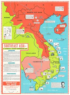
Southeast Asia - A Small War Grows Up. Headline-Focus Wall Map 4.
sold
- Digital Map Information
- Suitable for large format printing
- File Size: 54.33 MB
- File Type: ZIP / TIFF
- ICC color profile embedded
- Delivered instantly via download link
This is a 1965 Civil Education Service pictorial map of Southeast Asia. The map depicts the region from Burma and Thailand to the South China Sea and from China to the Gulf of Siam and the Ca Mau Peninsula. A product of the Cold War and the Vietnam War, the ideological fight between communism and capitalism is immediately apparent, with communist countries shaded red and capitalist countries shaded an almost neon green – ‘the color of money’, ironically. China and North Vietnam are colored red, while Laos is half red and half green, a vivid illustration of the fight between the Pathet Lao forces and the anti-communist government backed forces in that country. Thailand, Burma, and South Vietnam are all green, while Cambodia is a dull red, indicating its pro-communist stance but its officially neutral stance. Icons along the South Vietnamese coast indicate the locations of American naval, helicopter, and air bases situated throughout the country, as well as troop concentrations. Text boxes provide some context, highlighting for example the headquarters of the 1st Cavalry Airmobile Division and locations of important battles between communist and American forces. Other vignettes highlight the now famous Ho Chi Minh Trail, the North Vietnamese supply route from North Vietnam, through Laos, into South Vietnam, areas of guerrilla activity, and the U.S. Seventh Fleet stationed over the Vietnamese Coast. Short biographies of important leaders, including Ho Chi Minh, Nguyen Cao Ky, a South Vietnamese air force general who seized power in June 1965, Prince Sihanouk of Cambodia, and Prince Souvanna Phouma of Laos are included as well, and are accompanied by portraits. A text box in the lower left corner provides context and information concerning America’s escalating role in the region and an assessment of the current state of affairs there. (more details)
A map of Southeast Asia during the Vietnam War that was created for schoolchildren and clearly separates the communist countries from the capitalist countries in the region.
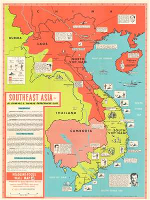
Southeast Asia - A Small War Grows Up. Headline-Focus Wall Map 4.
sold
- Digital Map Information
- Suitable for large format printing
- File Size: 53.76 MB
- File Type: ZIP / TIFF
- ICC color profile embedded
- Delivered instantly via download link
This is a 1965 Civil Education Service pictorial map of Southeast Asia. The map depicts the region from Burma and Thailand to the South China Sea and from China to the Gulf of Siam and the Ca Mau Peninsula. A product of the Cold War and the Vietnam War, the ideological fight between communism and capitalism is immediately apparent, with communist countries shaded red and capitalist countries shaded an almost neon green – ‘the color of money’, ironically. China and North Vietnam are colored red, while Laos is half red and half green, a vivid illustration of the fight between the Pathet Lao forces and the anti-communist government backed forces in that country. Thailand, Burma, and South Vietnam are all green, while Cambodia is a dull red, indicating its pro-communist stance but its officially neutral stance. Icons along the South Vietnamese coast indicate the locations of American naval, helicopter, and air bases situated throughout the country, as well as troop concentrations. Text boxes provide some context, highlighting for example the headquarters of the 1st Cavalry Airmobile Division and locations of important battles between communist and American forces. Other vignettes highlight the now famous Ho Chi Minh Trail, the North Vietnamese supply route from North Vietnam, through Laos, into South Vietnam, areas of guerrilla activity, and the U.S. Seventh Fleet stationed over the Vietnamese Coast. Short biographies of important leaders, including Ho Chi Minh, Nguyen Cao Ky, a South Vietnamese air force general who seized power in June 1965, Prince Sihanouk of Cambodia, and Prince Souvanna Phouma of Laos are included as well, and are accompanied by portraits. A text box in the lower left corner provides context and information concerning America’s escalating role in the region and an assessment of the current state of affairs there. (more details)
A map of Southeast Asia during the Vietnam War that was created for schoolchildren and clearly separates the communist countries from the capitalist countries in the region.
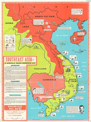
This is a 1965 Civil Education Service pictorial map of Southeast Asia. The map depicts the region from Burma and Thailand to the South China Sea and from China to the Gulf of Siam and the Ca Mau Peninsula. A product of the Cold War and the Vietnam War, the ideological fight between communism and capitalism is immediately apparent, with communist countries shaded red and capitalist countries shaded an almost neon green – ‘the color of money’, ironically. China and North Vietnam are colored red, while Laos is half red and half green, a vivid illustration of the fight between the Pathet Lao forces and the anti-communist government backed forces in that country. Thailand, Burma, and South Vietnam are all green, while Cambodia is a dull red, indicating its pro-communist stance but its officially neutral stance. Icons along the South Vietnamese coast indicate the locations of American naval, helicopter, and air bases situated throughout the country, as well as troop concentrations. Text boxes provide some context, highlighting for example the headquarters of the 1st Cavalry Airmobile Division and locations of important battles between communist and American forces. Other vignettes highlight the now famous Ho Chi Minh Trail, the North Vietnamese supply route from North Vietnam, through Laos, into South Vietnam, areas of guerrilla activity, and the U.S. Seventh Fleet stationed over the Vietnamese Coast. Short biographies of important leaders, including Ho Chi Minh, Nguyen Cao Ky, a South Vietnamese air force general who seized power in June 1965, Prince Sihanouk of Cambodia, and Prince Souvanna Phouma of Laos are included as well, and are accompanied by portraits. A text box in the lower left corner provides context and information concerning America’s escalating role in the region and an assessment of the current state of affairs there. (more details)
Communists and Capitalists during the Vietnam War.
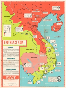
This is a 1965 Civil Education Service pictorial map of Southeast Asia highlighting regional social and political divisions during the Vietnam War. (more details)
Teaching schoolchildren about the Dominican Civil War.
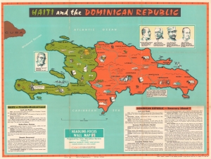
This is a 1965 Civic Education Service wall map of Haiti and the Dominican Republic, which occupy the island of Hispaniola. This map was produced to educate schoolchildren about the Dominican Civil War and the continued dictatorship in Haiti. (more details)
Full Civic Education Educational Packet, including maps and articles.
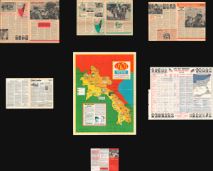
This is a rare 1966 Civic Education Service pictorial wall map of Laos during the Vietnam War (Second Indochina War). This example is not just the map, but the full educational packet, with supplementary maps and news articles - the first such example we've come across. Produced just prior to the point where U.S. troop levels in Vietnam peaked, it reflects an effort to educate the American public about the country's involvement in a region with which few were familiar. (more details)
A Vietnam War era map of Laos highlighting the Laotian Civil War and the Ho Chi Minh Trail.
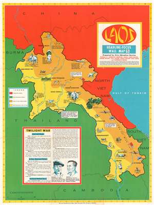
Laos. Headline-Focus Wall Map 5.
sold
- Digital Map Information
- Suitable for large format printing
- File Size: 75.6 MB
- File Type: ZIP / TIFF
- ICC color profile embedded
- Delivered instantly via download link
This is a rare 1966 Civic Education Service pictorial map of Laos during the Vietnam War. The map depicts the region from Thailand and Burma to the Gulf of Tonkin and from China to Cambodia and South Vietnam. Strikingly colored, Laos, shaded yellow, occupies the map's center. The bright yellow indicates which portions of the country were controlled by non-communist forces, per the legend along the left side, which, most likely, is meant to be read as 'pro-U.S.' The shaded portion of Laos is the part of the country under the control of Communist forces, or the 'area of Laos held by Reds' as the legend states. This dichotomy, along with the brilliant red used to denote Communist countries and the green (the color of money) marking non-Communist countries, easily encapsulates the region's political turmoil during this era. Vignettes accompany captions concerning life in Laos, such as the nation's most important export (lumber), a Laotian mountain village, and some of the traditional dress of the tribal Meo people. Vientiane, the capital of Laos, and Luang Prabang, the location of the Laotian Royal Palace, are both labeled, as are several other towns and villages. (more details)
Peace in Vietnam?
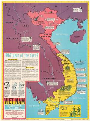
This is a 1967 Civic Education Service pictorial map of Vietnam during the Vietnam War. Pictorial vignettes illustrate American, South Korean, and Australian forces fighting in South Vietnam, along with American bombing raids and North Vietnamese antiaircraft guns in North Vietnam. Text boxes provide short summaries of events. Text in the lower-left summarizes Vietnam in early 1967 with an emphasis that North Vietnam and the United States could soon enter peace talks. (more details)
Combines information about the Presidency, the Electoral College, major American political parties, and voting trends.
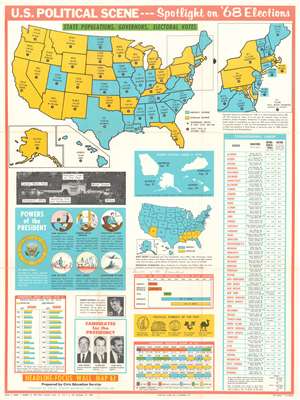
Headline Focus Wall Map 1. U.S. Political Scene - - Spotlight on '68 Elections.
sold
- Digital Map Information
- Suitable for large format printing
- File Size: 49.4 MB
- File Type: ZIP / TIFF
- ICC color profile embedded
- Delivered instantly via download link
This is a 1968 Civic Education Service broadside of the 1968 U.S. presidential election. The broadside combines an electoral map of the United States with information about the Presidency, American political history, voting trends, and photographs of the then-current candidates for the Presidency: Hubert Humphrey, Richard Nixon, and George Wallace. A political map of the United States occupies the top third of the broadside and provides viewers with information concerning each state's population, the governor's name, and the number of electoral votes allocated to each state. An inset to the right of the map of the continental U.S. focuses on the northeast, illustrating the region from Maine to Virginia. Two other insets, below and to the left of the large map, includes Alaska and Hawaii. (more details)
Chile's political stability is questioned while the military junta in Argentina is supported since it was an ally of the United States.
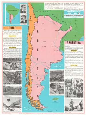
Chile. Argentina. Headline-Focus Wall Map 6.
sold
- Digital Map Information
- Suitable for large format printing
- File Size: 81.7 MB
- File Type: ZIP / TIFF
- ICC color profile embedded
- Delivered instantly via download link
This is a 1968 Civic Education Service map of Argentina and Chile. This map focuses less on the geography of the region and more on its political, social, and economic realities. Cities are labeled throughout both countries, as are rivers and the Andes Mountains, which make up most of the border separating them. A text in the upper right corner summarizes the similarities between the two countries, while text boxes on the left and right sides focus on Chile and Argentina, respectively, shed light on the differences between the two nations. (more details)
Divides Africa into three racial zones: Arab Africa, Black Africa, and White-ruled Africa.
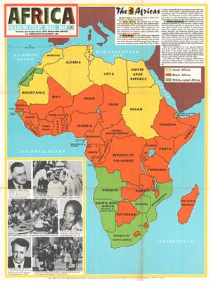
Africa. Headline-Focus Wall Map 14. The 3 Africas.
sold
- Digital Map Information
- Suitable for large format printing
- File Size: 66.47 MB
- File Type: ZIP / TIFF
- ICC color profile embedded
- Delivered instantly via download link
This 1970 Civic Education Service map of Africa divides the continent into three parts: 'modern Africa' is made up of 'Arab Africa', 'Black Africa', and 'White-ruled Africa'. The countries that create each of these regions are shaded either yellow ('Arab Africa'), orange ('Black Africa'), or green ('White-ruled Africa'), and each region is described very succinctly in a text box situated in the upper right corner. (more details)
Published only six weeks after the end of the Nigerian Civil War.
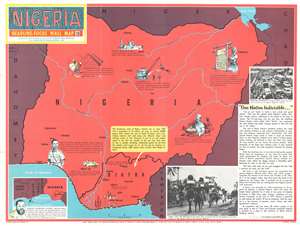
Nigeria. Headline-Focus Wall Map 10.
sold
- Digital Map Information
- Suitable for large format printing
- File Size: 59.18 MB
- File Type: ZIP / TIFF
- ICC color profile embedded
- Delivered instantly via download link
Published only six weeks after the Nigerian Civil War, this is a 1970 Civic Education Service map of Nigeria. Major cities are labeled throughout, with several highlighted in secessionist Biafra. (more details)