
Eşref, Mehmet (sold)

Mehmet Esref (1846 or 1847-1912) was a Turkish educator and publisher active in the first part of the 20th century. He published several historical and educational atlases, all of which are rare on the market and contain many of the first Turkish maps of the regions they depict.
One of the Only Acquirable Turkish Maps of showing Transatlantic Telegraphs
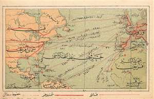
(Turkish Map of North America and Europe showing Transatlantic and Transcontinental Telegraph Cables
sold
- Digital Map Information
- Suitable for large format printing
- File Size: 1.09 MB
- File Type: ZIP / TIFF
- ICC color profile embedded
- Delivered instantly via download link
This is a 1909 Turkish map of North America and Europe, marking the positions of major telegraph cables, both transatlantic and transcontinental. It was produced by the educator and publisher Mehmet Eşref, and may well be the only such printed map available to the collector. All titles and descriptive text is in Ottoman Turkish. National borders are not shown, but major features such as the Great Lakes and the Mississippi do appear. The telegraph routes are marked in red. Chromolithograph. (more details)
One of the Only Acquirable Turkish Maps of Singapore and Borneo
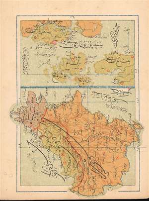
(Turkish Map of Singapore and Borneo)
sold
- Digital Map Information
- Suitable for large format printing
- File Size: 1.15 MB
- File Type: ZIP / TIFF
- ICC color profile embedded
- Delivered instantly via download link
This is a 1909 Turkish map of the Singapore Strait and island of Singapore, combined with a map of Borneo, produced by the Turkish educator and publisher Mehmet Eşref. Most likely the only specific Ottoman map of these areas available to the collector. All titles and descriptive text are in Ottoman Turkish. On the Singapore Straits portion of the map, the city of Singapore itself is marked in red hachure. The map of Borneo is oriented to the west, and its colonial division between the English and the Dutch -which would materially affect the political boundaries of post-colonial Borneo- is indicated with color. Chromolithograph. (more details)
Attracive Miniature Turkish Hemisphere Maps
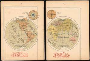
[Turkish Maps of the Eastern and Western Hemispheres]
sold
- Digital Map Information
- Suitable for large format printing
- File Size: 2.15 MB
- File Type: ZIP / TIFF
- ICC color profile embedded
- Delivered instantly via download link
This is a pair of 1909 Turkish Eastern and Western Hemisphere maps, produced by the educator and publisher Mehmet Eşref. Together they comprise one of the few Turkish maps of the world available to the collector. All titles and descriptive text are in Ottoman Turkish. National borders are not shown, but large geographical features - the Great Lakes, the Mississippi River, the Amazon and the Nile do appear. Antarctica is shown in a tentative fashion. Chromolithograph. (more details)
A Rare, Attractive Miniature Turkish Plan of Istanbul
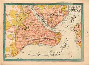
(Turkish Plan of Istanbul and its Surrounds)
sold
- Digital Map Information
- Suitable for large format printing
- File Size: 1.33 MB
- File Type: ZIP / TIFF
- ICC color profile embedded
- Delivered instantly via download link
This is a 1909 Turkish plan of Istanbul, produced by the Turkish educator and publisher Mehmet Eşref. All titles and descriptive text are in Ottoman Turkish. Areas within the city and its suburbs are made distinct with color. Depth soundings are noted in the waterways, and the famous 'Maiden's Tower,' or Kiz Kulesi, is marked just off the shore from Üsküdar. Chromolithograph. (more details)