
Gibson, John (sold)

John Gibson (1724 – 1773) was an English map engraver active in London at the end of the 18th century. Gibson was the son of a locksmith. In 1739 he apprenticed to John Blundell as a stationer of Grub Street. Gibson proved a fine engraver and was much in demand by London map publishers. During his career he produced thousands of maps and was admired as a skilled engraver and sculptor. Among others, he engraved for Emanuel Bowen, Robert Sayer, Jean Palairet, John Rocque, Andrew Dury, and Benjamin Martin. His best known work was prepared in conjunction with Gentleman's Magazine. Gibson, sadly, was not as astute in his fiscal affairs as with the engravers pen and consequently spent much of his life consigned to debtor's prison.
Exceptionally rare 1755 map of Norway and Sweden. Only one copy in the OCLC.
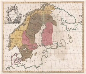
Carte de Norwége & 1e. de Suéde.
sold
- Digital Map Information
- Suitable for large format printing
- DPI: 300
- File Size: 12.34 MB
- File Type: ZIP / TIFF
- ICC color profile embedded
- Delivered instantly via download link
A 1755 map of Scandinavia of considerable rarity by Jean Palairet and John Gibson. Map covers Norway and Sweden from the high Arctic to the Baltic Sea and from the Atlantic Ocean to Finland. There is little topography except for a mountain range separating Norway ... (more details)
Also known as the Battle of the Plains of Abraham, this battle was a key British victory in the French and Indian War.
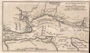
An Authentic Plan of the River St. Laurence, from Sillery to the Falls of Montmorency.
sold
- Digital Map Information
- Suitable for large format printing
- DPI: 300
- File Size: 1.1 MB
- File Type: ZIP / TIFF
- ICC color profile embedded
- Delivered instantly via download link
This is a 1759 John Gibson map of the Battle of Quebec during the French and Indian War, the name for the North American theater during the 7 Years' War between Britain and France. Also known as the Battle of the Plains of Abraham, the map depicts the region from the sillery to Montmorency Falls and from Charlebourg to the Isle of Orleans (Isle d'Orléans). The blockading British fleet is illustrated in the St. Lawrence, while French encampments are labeled all along the river from Quebec City to the Montmorency Falls. The battle, which took place to the west of Quebec City, is illustrated by French and British battle lines. (more details)
Also known as the Battle of the Plains of Abraham, this battle was a key British victory in the French and Indian War.
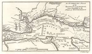
An Authentic Plan of the River St. Laurence, from Sillery to the Falls of Montmorency.
sold
- Digital Map Information
- Suitable for large format printing
- DPI: 600
- File Size: 2.03 MB
- File Type: ZIP / TIFF
- ICC color profile embedded
- Delivered instantly via download link
This is a 1759 John Gibson map of the Battle of Quebec during the French and Indian War, the name for the North American theater during the 7 Years' War between Britain and France. Also known as the Battle of the Plains of Abraham, the map depicts the region from the sillery to Montmorency Falls and from Charlebourg to the Isle of Orleans (Isle d'Orléans). The blockading British fleet is illustrated in the St. Lawrence, while French encampments are labeled all along the river from Quebec City to the Montmorency Falls. The battle, which took place to the west of Quebec City, is illustrated by French and British battle lines. (more details)
Dashed Hopes of a Northwest Passage.
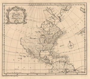
North America.
sold
- Digital Map Information
- Suitable for large format printing
- File Size: 6.9 MB
- File Type: ZIP / TIFF
- ICC color profile embedded
- Delivered instantly via download link
This is a c. 1759 map of North America engraved by John Gibson for Thomas Salmon's The Universal Traveller: Or, a Compleat Description of the Nations of the World. It is notable for reflecting the still-speculative nature of the continent's geography, including suggestions of a possible Northwest Passage. (more details)
Britain's Prize in America following the French and Indian War.
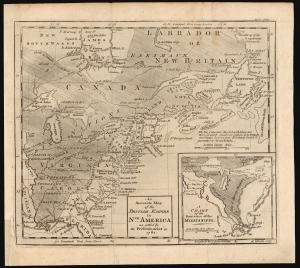
An Accurate Map of the British Empire in Nth. America as settled by the Preliminaries in 1762.
sold
- Digital Map Information
- Suitable for large format printing
- DPI: 600
- File Size: 12.76 MB
- File Type: ZIP / TIFF
- ICC color profile embedded
- Delivered instantly via download link
This scarce, fascinating map of North America east of the Mississippi appeared in the 1762 end-of-year supplement of the Gentleman's Magazine. It revealed, to that magazine's readership, the vast prize of American land that Great Britain stood to gain at the expense of the French in the treaty negotiations then bringing the French and Indian War (1754 - 1763) to a close. (more details)
Rare map revealing the Russo-Persian Frontier.
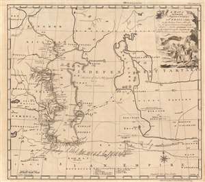
A Map of the Routs of the Russian Embassy to Persia in 1746, also of Mr. George Thompson's journey on the East and the author's travels on the South coast of the Caspian sea, with Mr. Van Mierop's Journey to Mesched.
sold
- Digital Map Information
- Suitable for large format printing
- Full resolution TIFF file
- ICC color profile embedded
- Delivered instantly via download link
This is an example of John Gibson's rare map of the Caspian region, engraved in 1753 to accompany Jonas Hanway's account of his journey from Russia to Persia. It represents one of the first and best detailed, maps of the region based on firsthand exploration. The map combines details of Hanway's own journey with reconnaissance from the 1740 journey of British merchant George Thompson, that of Martin Kyck van Mierop, a cloth merchant who traveled the region in 1746, and an abortive 1746 Russian embassy to Persia on behalf of the Tsarina Elizabeth Petrovna. The map shows the area around the Caspian Sea and northern Iran, as well as parts of modern-day Turkmenistan and Uzbekistan. (more details)
Two nautical charts from Cook's first voyage printed on one sheet.
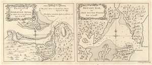
Entrance of Endeavour River, in New South Wales. / Botany Bay, in New South Wales.
sold
- Digital Map Information
- Suitable for large format printing
- DPI: 600
- File Size: 4.86 MB
- File Type: ZIP / TIFF
- ICC color profile embedded
- Delivered instantly via download link
This is a 1773 Captain James Cook set of two maps of the entrance to the Endeavour River and Botany Bay in Australia, both of which Cook discovered on his first voyage. Each map focuses on its respective region, with the Endeavour River on the left and Botany Bay on the right. (more details)