
Kodansha

Kodansha (株式会社講談社, 1909 - Present), also known in the early Shōwa period as Dai Nippon Yūbenkai Kōdansha (大日本雄弁会講談社), is a Japanese publishing house founded in 1909 by Seiji Noma (野間淸治). Seiji founded Kodansha as a spin-off from the Dai-Nippon Yūbenkai (Greater Japan Oratorical Society) and produced the literary magazine Yūben as its first publication. The name Kodansha, a derivative of the defunct magazine Kōdan Club (Storytelling Club), in 1911, which it merged with the Dai-Nippon Yūbenkai. In 1925, Kodansha launched King (キング) , the first magazine to sell 1,000,000 copies in its first printing. Kōdansha published several other magazines including Women's Club (婦人倶樂部) and Boy's Club (少年倶樂部) and had become a major shaper of Japanese culture and public opinion by the 1930s, controlling 70% of the magazine market. Kōdansha suffered difficulties during the war period, due to both intense censorship and the 1938 death of both Noma Seiji and his son, Noma Hasashi (野間恒), within weeks of one another. Still, the company survived the wartime era and, after a period of difficulties during the U.S. Occupation due to Kōdansha's endorsement of militarism, benefitted from a postwar publishing revival. Although King and other magazines ceased publication in the postwar period, Kōdansha branched into other areas, including manga and music recording, and is now the largest publisher in Japan.
Japan's Pre-WWII self actualization as a world power.

Round the World Competition. / 世界一週競争双六
$750.00
Acquire
- Digital Map Information
- Suitable for large format printing
- Full resolution TIFF file
- ICC color profile embedded
- Delivered instantly via download link
A scarce 1926 Japanese 'round the world' sugoroku game and pictorial map of the world by Saburo Ota (太田三郎). This map is emblematic of Japan's self-actualization as a world power in the first half of the 20th century. It also hits at the influence of Japanese manga printing on 20th-century American and European pictorial cartography. (more details)
The trans-Pacific aviation race.
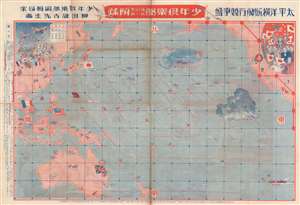
太平洋横断飛行競争盤 / Trans-Pacific Flight Game Board. / 城攻め一番乗り双六 / Castle Attack Sugoroku.
$750.00
Acquire
- Digital Map Information
- Suitable for large format printing
- Full resolution TIFF file
- ICC color profile embedded
- Delivered instantly via download link
This is a rare 1927 (Showa 2) map and Sugoroku board drawn to promote Japanese ambitions to achieve the first solo trans-Pacific flight. The map was published by Dainippon Yutsukai Kodansha (大日本雄辯會講談社) as a New Year supplement to their 'Japanese Youth Club' periodical. The map is printed on both sides. The more interesting side (to us), is the trans-pacific flight Sugoroku. The opposite side features a brightly lithographed castle siege game. (more details)
Japan Joins the Great Age of Polar Exploration,
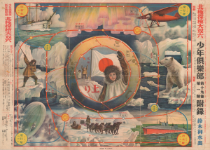
北極探檢大双六 / [Great Arctic Exploration Sugoroku].
$750.00
Acquire
- Digital Map Information
- Suitable for large format printing
- File Size: 29.48 MB
- File Type: ZIP / TIFF
- ICC color profile embedded
- Delivered instantly via download link
This vibrant 1932 chromolithographic broadsheet map was prepared by artist Suzuki Gyosui as a sugoroku game board, a supplement to the New Year's edition of Boys Club magazine, published by Kodansha. It was produced at a time of heightened interest in great feats of exploration in Japan, especially among the country's youth. (more details)
Gathering storm clouds over Europe, as seen from Japan.
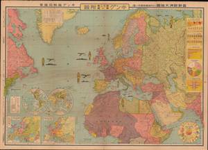
最新歐洲大地圖 (附列強國勢國防一覽) / [Latest Map of Europe (with an overview of the national strength and defenses of the major powers)].
$750.00
Acquire
- Digital Map Information
- Suitable for large format printing
- File Size: 80.15 MB
- File Type: ZIP / TIFF
- ICC color profile embedded
- Delivered instantly via download link
This is a very rare and unusual Japanese portrayal of European military power by Fuchida Tadayoshi - illustrated to support Japanese interest in the increasingly tense situation in Europe, as well as to emphasize to the Japanese public the value of European alliances. It was published as a supplement to the January 1, 1936 (Showa 11), edition of King (キング) magazine. The map, along with the included insets, charts, and graphs, describes the military and economic situation in Europe at the time and the relationship of Japan to the emerging European conflict. (more details)
The nadir of China's WWII experience.
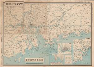
廣東香港明細地圖 ; 漢口南昌明細地圖 / [Detailed map of Guangdong and Hong Kong; Detailed map of Hankou and Nanchang].
$300.00
Acquire
- Digital Map Information
- Suitable for large format printing
- Full resolution TIFF file
- ICC color profile embedded
- Delivered instantly via download link
This is a pair of maps (front and back of the same sheet) from 1938 covering Guangdong, Hong Kong, and the Central Yangzi Region, including Hankou and Nanchang (now Wuhan), made during the Second Sino-Japanese War (World War II). It was published in King (キング) magazine, a popular general interest monthly. (more details)
War for Japanese women.
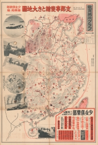
支那事變繪とき大地圖 / [Sino-Japanese War and Resources].
$900.00
Acquire
- Digital Map Information
- Suitable for large format printing
- File Size: 69.31 MB
- File Type: ZIP / TIFF
- ICC color profile embedded
- Delivered instantly via download link
A rare 1939 map of China during the Second Sino-Japanese War (1937 - 1845) issued by Kodansha for Fujin Kurabu, a Japanese women's magazine. The map was issued to propagandize the war effort on the home front. (more details)