
Mayer, Ferdinand (sold)
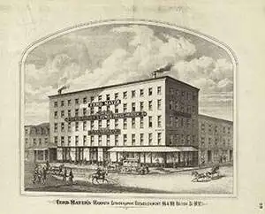
Ferdinand Mayer (October 19, 1817 - November 14, 1879) was a prosperous lithographer based in New York during the latter part of the 19th century. Mayer was born in Württemberg, Germany, but emigrated to the United States following the 1848 March Revolutions that swept through the German Confederation - maybe as late as 1854. Initially, Mayer was associated with various partners, including Prang, Nagel, and Korff - also German immigrants. By 1855, he established himself at 96 Fulton Street and, within a few years, expanded to the neighboring property at 98 Fulton Street. Meyer produced an enormous corpus of varied work, including music sheets, bank notes, broadsides, maps, and views. His career was probably jumpstarted through an early partnership with the important cartographer Henry Walling, many of whose maps and atlases bear the 'Ferd. Mayer' imprint. His most important publication is most likely Egbert L. Vielé's 1865 Topographical Map of the City of New York, one of the most important and influential maps of New York City ever published. The Mayer imprint appears on documents as, variously, 'Ferd. Meyer', 'F. Mayer', and 'Mayer and Sons'.
Highlights Mount Morris Park, which hosted the Harlem Cultural Festival, known as the Black Woodstock, in 1969.
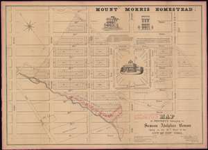
Map of the Property belonging to Samson Adolphus Benson Lying in the 12th War of the City of New-York.
sold
- Digital Map Information
- Suitable for large format printing
- DPI: 600
- File Size: 42.43 MB
- File Type: ZIP / TIFF
- ICC color profile embedded
- Delivered instantly via download link
A fine example Francis Nicholson's rare 1848 cadastral map of the Mount Morris Park historic district - the only specific map of this area to appear in the 19th century. The map depicts the region from Eighth Avenue to Fourth Avenue and from 127th Street to 116th Street. Streets and avenues are identified and all the buildings and city blocks are numbered. Harlem Creek, which has long since been buried under the development of Manhattan, is illustrated. Manuscript notations in red ink illustrate the land holdings of Abraham Bussing, John Bussing, and Adolph Bussing. (more details)
Early view of what would become New York City's Central Park.
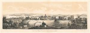
View from Mount Prospect [Central Park], Looking East.
sold
- Digital Map Information
- Suitable for large format printing
- File Size: 5.01 MB
- File Type: ZIP / TIFF
- ICC color profile embedded
- Delivered instantly via download link
This is an unusual c. 1860 Augustus Rubstein view looking east from Mount Prospect (the Great Hill), Central Park, New York City. In the foreground, we see a couple and a child standing on what is today the known as the Great Hill, looking toward the East River and beyond to pasture lands. A train can be seen crossing a bridge. McGowan's Pass and the Mount St. Vincent Convent - which was subsequently relocated to the Bronx, where it still exists, can be seen in the center. (more details)
One of the most beautiful, important, and enduring maps of Manhattan ever published.
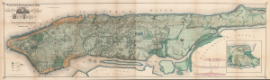
Topographical Map of the City of New York Showing Original Water Courses and Made Land.
sold
- Digital Map Information
- Suitable for large format printing
- Full resolution TIFF file
- ICC color profile embedded
- Delivered instantly via download link
This is a beautiful example of Egbert L. Viele's 1865 topography and waterways map of Manhattan, one of the scarcest, most important, and most enduring maps of New York City ever published. Viele's map details the canals, swamps, rivers, ditches, ponds, meadows, and drainage basins of Manhattan as they existed prior to the city's urban development. A version of the Viele map remains in use today by architects and contractors who need to be certain they are not building over underground rivers and swamps that may destabilize a new construction's foundation. (more details)
One of the most beautiful, important, and enduring maps of Manhattan ever published.
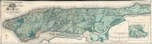
Sanitary and Topographical Map of the City and Island of New York Prepared for the Council of Hygiene and Public Health, of the Citizens Association.
sold
- Digital Map Information
- Suitable for large format printing
- File Size: 74.33 MB
- File Type: ZIP / TIFF
- ICC color profile embedded
- Delivered instantly via download link
This is a very beautiful and fine example of Egbert L. Viele's 1865 topography and waterways map of Manhattan, one of the scarcest, most important, and most enduring maps of New York City ever published. Covering the entirety of Manhattan Island, Viele's map details the canals, swamps, rivers, ditches, ponds, meadows, and drainage basins of Manhattan as they existed prior to the city's urban development. A version of the Viele map remains in use today by architects and contractors who need to be certain they are not building over underground rivers and swamps that may destabilize a new construction's foundation. (more details)
One of the most beautiful, important, and enduring maps of Manhattan ever published.
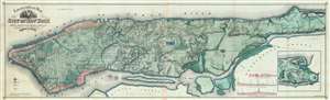
Topographical Map of the City of New York showing original water courses and made land.
sold
- Digital Map Information
- Suitable for large format printing
- File Size: 92.32 MB
- File Type: ZIP / TIFF
- ICC color profile embedded
- Delivered instantly via download link
This is Egbert L. Viele's 1865 topography and waterways map of Manhattan, one of the scarcest, most important, and most enduring maps of New York City ever published. Covering the entirety of Manhattan Island, Viele's map details the canals, swamps, rivers, ditches, ponds, meadows, and drainage basins of Manhattan as they existed prior to the city's urban development. A version of the Viele map remains in use today by architects and contractors who need to be certain they are not building over underground rivers and swamps that may destabilize a new construction's foundation. (more details)
One of the most beautiful, important, and enduring maps of Manhattan ever published.
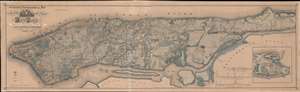
Sanitary and Topographical Map of the City and Island of New York. Prepared for the Council of Hygiene and Public Health of the Citizens Association.
sold
- Digital Map Information
- Suitable for large format printing
- File Size: 82.92 MB
- File Type: ZIP / TIFF
- ICC color profile embedded
- Delivered instantly via download link
This is Egbert L. Viele's 1865 topography and waterways map of Manhattan, one of the scarcest, most important, and most enduring maps of New York City ever published. Covering the entirety of Manhattan Island, Viele's map details the canals, swamps, rivers, ditches, ponds, meadows, and drainage basins of Manhattan as they existed prior to the city's urban development. A version of the Viele map remains in use today by architects and contractors who need to be certain they are not building over underground rivers and swamps that may destabilize a new construction's foundation. (more details)
One of the most beautiful, important, and enduring maps of Manhattan ever published.
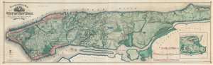
Topographical Map of the City of New York showing original water courses and made land.
sold
- Digital Map Information
- Suitable for large format printing
- Full resolution TIFF file
- ICC color profile embedded
- Delivered instantly via download link
This is a very beautiful and fine example of Egbert L. Viele's 1865 topography and waterways map of Manhattan, one of the scarcest, most important, and most enduring maps of New York City ever published. Covering the entirety of Manhattan Island, Viele's map details the canals, swamps, rivers, ditches, ponds, meadows, and drainage basins of Manhattan as they existed prior to the city's urban development. A version of the Viele map remains in use today by architects and contractors who need to be certain they are not building over underground rivers and swamps that may destabilize a new construction's foundation. (more details)
One of the most beautiful, important, and enduring maps of Manhattan ever published.
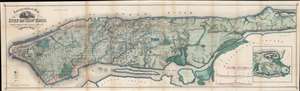
Topographical Map of the City of New York Showing Original Water Courses and Made Land.
sold
- Digital Map Information
- Suitable for large format printing
- File Size: 71.25 MB
- File Type: ZIP / TIFF
- ICC color profile embedded
- Delivered instantly via download link
This is a very beautiful and fine example of Egbert L. Viele's 1865 topography and waterways map of Manhattan, one of the scarcest, most important, and most enduring maps of New York City ever published. Covering the entirety of Manhattan Island, Viele's map details the canals, swamps, rivers, ditches, ponds, meadows, and drainage basins of Manhattan as they existed prior to the city's urban development. A version of the Viele map remains in use today by architects and contractors who need to be certain they are not building over underground rivers and swamps that may destabilize a new construction's foundation. (more details)
One of the most beautiful, important, and enduring maps of Manhattan ever published.
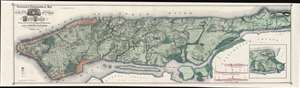
Topographical Map of the City of New York Showing Original Water Courses and Made Land.
sold
- Digital Map Information
- Suitable for large format printing
- File Size: 86.7 MB
- File Type: ZIP / TIFF
- ICC color profile embedded
- Delivered instantly via download link
This is a very beautiful and fine example of Egbert L. Viele's 1865 topography and waterways map of Manhattan, one of the scarcest, most important, and most enduring maps of New York City ever published. Covering the entirety of Manhattan Island, Viele's map details the canals, swamps, rivers, ditches, ponds, meadows, and drainage basins of Manhattan as they existed prior to the city's urban development. A version of the Viele map remains in use today by architects and contractors who need to be certain they are not building over underground rivers and swamps that may destabilize a new construction's foundation. (more details)
Sherman's March to the Sea.
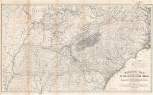
Military Map Showing the Marches of the United States Forces Under Command of Maj. Gen. W. T. Sherman. U.S.A. During the Years 1863, 1864, 1865.
sold
- Digital Map Information
- Suitable for large format printing
- File Size: 83.33 MB
- File Type: ZIP / TIFF
- ICC color profile embedded
- Delivered instantly via download link
This is an 1865 William Kossak map of the southeastern United States tracing the movements of Union Army forces under the command of Major General William Tecumseh Sherman in 1863, 1864, and 1865. Coverage extends from Missouri, Arkansas, and Louisiana to North Carolina and the Atlantic Ocean, and from Missouri, Illinois, Indiana, Kentucky, Ohio, and Virginia to Mobile Bay. Throughout Kossak, and John B. Muller, a draughtsman, achieve astounding detail. The routes followed by General Sherman's units, which include the 4th, 14th, 15th, 16th, 17th, and 20th Army Corps are illustrated. Sherman's movement on Atlanta (a massive operation during which he orchestrated the movements of three separate armies) and Sherman's pursuit of Confederate General John Bell Hood both appear as well. The movements of General J. H. Wilson's Cavalry Corps and those of General G. Stoneman's Cavalry Corps are also depicted, along with Union and Rebel fortifications. (more details)
One of the most beautiful, important, and enduring maps of Manhattan ever published.
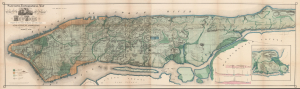
Sanitary and Topographical Map of the City and Island of New York Prepared for the Council of Hygiene and Public Health, of the Citizens Association.
sold
- Digital Map Information
- Suitable for large format printing
- Full resolution TIFF file
- ICC color profile embedded
- Delivered instantly via download link
This is Egbert L. Viele's large-format 1865 topography and waterways map of Manhattan, or the City of New York as it was then. It is one of the scarcest, most important, and most enduring maps of New York City ever published. This particular example is a rare variant appearing in the Report of the Council of Hygiene and Public Health of the Citizens' Association of New York upon the Sanitary Condition of the City and also has the esteemed provenance of being connected to the French Consulate in New York City. (more details)
Only known example of 1867 lithograph of Balling's famous mural.
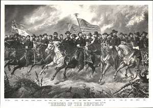
Heroes of the Republic.
sold
- Digital Map Information
- Suitable for large format printing
- File Size: 118.3 MB
- File Type: ZIP / TIFF
- ICC color profile embedded
- Delivered instantly via download link
The only known surviving example of a rare 1867 Civil War view illustrating the 'Heroes of the Republic'. The view is based on a mural by Hansen 'Ole Peter' Balling, presented in 1865, just as the war ended. It is centered on General Ulysses S. Grant (1822 - 1885), with General William Tecumseh Sherman (1869 - 1883) on his left. The duo are surrounded by an additional 25 generals, all mounted. The banners of the Union are being held aloft. We note that the generals look remarkably calm and composed considering that they are charging their warhorses over rough terrain. (more details)
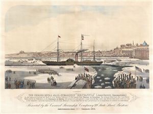
The Cunard Royal Mail Steamship 'Brittania' (John Hewitt, Commander.)
sold
- Digital Map Information
- Suitable for large format printing
- File Size: 14.51 MB
- File Type: ZIP / TIFF
- ICC color profile embedded
- Delivered instantly via download link
A fine 1876 view of Boston Harbor published by Ferdinand Meyer. This view, centered on the Royal Mail Steamship RMS Britannia , commemorates the exceptionally cold winter of 1844. By February of that year Boston Harbor was completely closed by ice. Commerce, long ... (more details)