
Wallingford, Daniel Kirkwood (sold)

Daniel Kirkwood Wallingford (September 12, 1890 – January 11, 1964) was an American industrial designer and artist. He was born in St. Paul, Minnesota, the son of an architect. Wallingford, first came to national attention as a schoolboy in Indianapolis, when he was so moved by the 1898 explosion of the battleship Maine, off Cuba, that he he donated his life savings of 49 cents to the Dept. of the Navy with a note reading, 'I saved the money myself. I got part of it for having my tooth pulled and I save part of it from Christmas ... I wanted to help build a ship'. For his patriotism a steel-sheathed tugboat was named after him. Wallingford went on to attend Phillips Andover Academy, then Cornell University where studied Architecture and Industrial Design and was a member of the Sigma Chi Fraternity. From 1917 - 1919, he served in World War I (1914 - 1818) and as Lieutenant Colonel of Artillery in World War II (1939 - 1945). He is known for two important maps, New Yorker's View of the United States of America and The Bostonian's View of the United States of America. Both maps were revolutionary in the evolution of the American pictorial map for their satirical depiction of New York and Boston, respectively. The New Yorker's View, Wallingford's first map, was initially issued in 1932 in just 100 prints, which Wallingford distributed as Christmas gifts. The map proved so popular he revised it and proceed a second edition in 1935. Later, in March of 1976, a modified version appeared as a New Yorker cover. Shortly after moving to Boston in 1936, he issued his second map, the The Bostonian's View, also sold via mail order. A third less famous map, A Bookman's Idea of the United States was published in 1938. Wallingford was most likely inspired by John T. McCutcheon's 1922 New Yorker's View of the World and intern inspired a number of subsequent artists including John Roman (Cowboy America) and Ernest Dudley Chase (The United States as Viewed by California). Despite the near iconic popularity of his two famous maps, little is known of Wallingford's personal life. Wallingford died in 1964 and was survived by his wife, Margaret.
Iconic humorous map satirizing the stereotypical insular Bostonian.
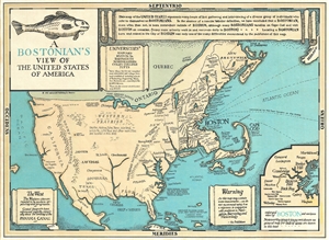
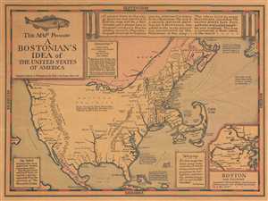
This is an enlarged later (1975) edition of Wallingford's 1936 humorous aggregate cognitive map 'Bostonian's View of the United States of America.' The map pokes fun at the stereotypical provincially minded Bostonian, who knows and cares little about the world ... (more details)
Iconic humorous map satirizing the stereotypical insular Bostonian.
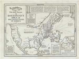
This is a reduced edition of Wallingford’s 1936 humorous aggregate cognitive map 'Bostonian's View of the United States of America.' The map pokes fun at the stereotypical provincially minded Bostonian, who knows and cares little about the world outside of ... (more details)
Lampooning the Provincial Bostonian.
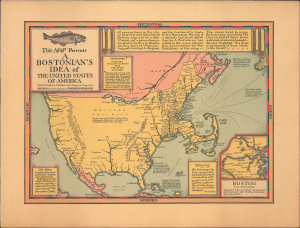
This is a 1936 / 1964 Daniel Wallingford map of the United States as viewed by the stereotypical Bostonian, reissued after his death by his widow, Margaret G. Wallingford. It lampoons Boston and New England-centric biases and is an early example of the 'Brags Map' genre, which Wallingford did much to define. (more details)
Lampooning the Provincial Bostonian.
This Map Presents A Bostonian's Idea of the United States of America.
sold
- Digital Map Information
- Suitable for large format printing
- File Size: 36.64 MB
- File Type: ZIP / TIFF
- ICC color profile embedded
- Delivered instantly via download link
This is a 1936 Daniel Wallingford map of the United States as viewed by the stereotypical Bostonian. It lampoons Boston and New England-centric biases in the pre-war era. (more details)
Iconic humorous map satirizing the stereotypical insular Bostonian.
This Map Presents A Bostonian's Idea of the United States of America.
sold
- Digital Map Information
- Suitable for large format printing
- File Size: 4.11 MB
- File Type: ZIP / TIFF
- ICC color profile embedded
- Delivered instantly via download link
This is a 1936 Daniel Wallingford map of the United States as viewed by the stereotypical Bostonian. Poking fun at the caricaturized idea of a Bostonian, the map depicts the country varying detail, with a high degree of accuracy and numerous cities and towns ... (more details)
Iconic humorous map satirizing the stereotypical insular Bostonian.
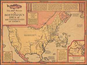
This Map Presents A Bostonian's Idea of the United States of America.
sold
- Digital Map Information
- Suitable for large format printing
- File Size: 4.16 MB
- File Type: ZIP / TIFF
- ICC color profile embedded
- Delivered instantly via download link
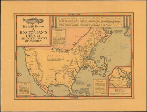
This is a 1936 Daniel Wallingford map of the United States as viewed by the stereotypical Bostonian. Poking fun at the caricaturized idea of a Bostonian, the map depicts the country varying detail, with a high degree of accuracy and numerous cities and towns labeled in the Northeast and decreasing accuracy and density of cities and towns further to the west. Cape Cod in particular is disproportionately enormous. The 'western prairies' the cities are listed, but not placed anywhere, rather are simply said to be 'located in this territory'. The Mississippi River barely extemds north beyhond Saint Louis, while Denver and Omaha are both decidedly West Coast cities. As a point of caution, the publishers have included a warning, 'As this map contains some inaccuracies, its use in connection with problems in navigation, astronomy, meteorology, etc. is not recommended.' An inset map of Boston and its environs is located in the lower right corner, with 'important cities and towns not shown on general map for lack of space are included in this inset.' It is also of note that Bali is no longer located in Indonesia, but just off the coast of Central America, per this map. (more details)
Iconic humorous map satirizing the stereotypical insular Bostonian.
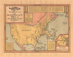
This Map Presents A Bostonian's Idea of the United States of America.
sold
- Digital Map Information
- Suitable for large format printing
- File Size: 13.44 MB
- File Type: ZIP / TIFF
- ICC color profile embedded
- Delivered instantly via download link
This is a 1936 Daniel Wallingford map of the United States as viewed by the stereotypical Bostonian. Poking fun at the caricaturized idea of a Bostonian, the map depicts the country varying detail, with a high degree of accuracy and numerous cities and towns labeled in the Northeast and decreasing accuracy and density of cities and towns further to the west. Cape Cod in particular is disproportionately enormous. The 'western prairies' the cities are listed, but not placed anywhere, rather are simply said to be 'located in this territory'. The Mississippi River barely extends north beyond Saint Louis, while Denver and Omaha are both decidedly West Coast cities. As a point of caution, the publishers have included a warning, 'As this map contains some inaccuracies, its use in connection with problems in navigation, astronomy, meteorology, etc. is not recommended.' An inset map of Boston and its environs is located in the lower right corner, with 'important cities and towns not shown on general map for lack of space are included in this inset.' It is also of note that Bali is no longer located in Indonesia, but just off the coast of Central America, per this map. (more details)
Iconic and hilarious pictorial map of the United States as imagined by a New Yorker in the 1930s.
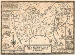
A New Yorker's Idea of The United States of America
sold
- Digital Map Information
- Suitable for large format printing
- File Size: 5.42 MB
- File Type: ZIP / TIFF
- ICC color profile embedded
- Delivered instantly via download link
This scarce and whimsical 1937 map depicts the United States, as seen by a 'typical' New Yorker - as envisaged by the Bostonian author, Daniel K. Wallingford. The map presents a highly distorted view of the country (and a similarly distorted view of the New Yorker), wherein New York State, and in particular Manhattan and Long Island are ludicrously out of proportion in relation to the rest of the country.
The map is a charming combination of humor and satire, depicting the provincialism of a New Yorker, to whom the rest of the country is unimportant. Names of places are either inaccurate or random, showing a New Yorker's supposed ignorance and disinterest in the rest of the country. The American southeast sports a massive Florida and four rivers, all named 'Swanee River'. Hollywood and San Francisco take up two-thirds of California and are shown as separate states. Minneapolis and Indianapolis are shown as 'twin cities' in Michigan, with Chicago, Milwaukee, St. Paul, Dubuque and Nebraska as cities in Illinois. Nevada is a city in Reno, and New Mexico is a city in Texas. The Great Salt Lake replaces Lake Superior, while Lake Michigan takes the name of Lake Superior. Lake Champlain is bigger than Lake Michigan, while Lake Erie is depicted as tiny lake in northern New York.
The map also includes beautiful illustrations of ships, whales, and islands; notable features of several states are also shown pictorially (e.g. the oil wells of Texas.) The lower right quadrant of the map includes four views of New York, including the Empire State building and the Fifth Avenue Coach. Another charming illustration along the lower border depicts a view of the desert and wagons on the left and a city and cars on the right. The upper left quadrant includes amusing text, attributed to actual New Yorkers: 'We have cousins in he west... they live in Wilmington, Delaware.' 'He is moving o Dallas so he can be near his mother in El Paso.' 'Indiana was an Indian Reservation until just recently, wasn't it?'. (more details)
The map is a charming combination of humor and satire, depicting the provincialism of a New Yorker, to whom the rest of the country is unimportant. Names of places are either inaccurate or random, showing a New Yorker's supposed ignorance and disinterest in the rest of the country. The American southeast sports a massive Florida and four rivers, all named 'Swanee River'. Hollywood and San Francisco take up two-thirds of California and are shown as separate states. Minneapolis and Indianapolis are shown as 'twin cities' in Michigan, with Chicago, Milwaukee, St. Paul, Dubuque and Nebraska as cities in Illinois. Nevada is a city in Reno, and New Mexico is a city in Texas. The Great Salt Lake replaces Lake Superior, while Lake Michigan takes the name of Lake Superior. Lake Champlain is bigger than Lake Michigan, while Lake Erie is depicted as tiny lake in northern New York.
The map also includes beautiful illustrations of ships, whales, and islands; notable features of several states are also shown pictorially (e.g. the oil wells of Texas.) The lower right quadrant of the map includes four views of New York, including the Empire State building and the Fifth Avenue Coach. Another charming illustration along the lower border depicts a view of the desert and wagons on the left and a city and cars on the right. The upper left quadrant includes amusing text, attributed to actual New Yorkers: 'We have cousins in he west... they live in Wilmington, Delaware.' 'He is moving o Dallas so he can be near his mother in El Paso.' 'Indiana was an Indian Reservation until just recently, wasn't it?'. (more details)

A New Yorker's Idea of The United States of America
sold
- Digital Map Information
- Suitable for large format printing
- File Size: 8.14 MB
- File Type: ZIP / TIFF
- ICC color profile embedded
- Delivered instantly via download link
This is scarce and whimsical 1939 map depicting a New Yorker's idea of the United States by Daniel K. Wallingford. The map depicts a distorted view of the United States, where New York State, Manhattan and Brooklyn are shown in oversize proportion to the ... (more details)
Iconic and hilarious pictorial map of the United States as imaged by a New Yorker in the 1930s.
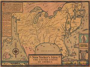
A New Yorker's Idea of The United States of America
sold
- Digital Map Information
- Suitable for large format printing
- File Size: 5.81 MB
- File Type: ZIP / TIFF
- ICC color profile embedded
- Delivered instantly via download link
This is a whimsical 1939 Daniel K. Wallingford pictorial map depicting a New Yorker's idea of the United States. Wallingford presents a humorously a distorted view of the United States, wherein New York State, Manhattan and Brooklyn, and other areas frequented by New Yorkers (Florida, Bermuda, etc.), are vastly outsized in proportion to the rest of the country. This edition was issued for the 1939 New York World's Fair, which is illustrated just north of Brooklyn. (more details)
Provincialism of 'some' New Yorkers.
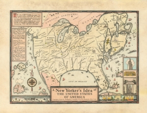
A New Yorker's Idea of The United States of America.
sold
- Digital Map Information
- Suitable for large format printing
- File Size: 27.68 MB
- File Type: ZIP / TIFF
- ICC color profile embedded
- Delivered instantly via download link
This is a whimsical 1939 Daniel K. Wallingford pictorial map depicting a New Yorker's idea of the United States. Wallingford presents a humorously distorted view of the United States, wherein New York State, Manhattan and Brooklyn, and other areas frequented by New Yorkers (Florida, Bermuda, etc.), are vastly outsized in proportion to the rest of the country. This edition was issued for the 1939 New York World's Fair, which is illustrated just north of Brooklyn. (more details)