
Gentleman's Magazine (sold)

The Gentleman's Magazine (fl. c. 1731 - 1922) was an English periodical founded by visionary Edward Cave. Considered the world's first monthly general interest magazine, GM was also known as Trader's Monthly Intelligencer. Cave's innovation was to create a monthly digest of news and commentary on any topic the educated public might be interested in, from commodity prices to Latin poetry. It carried original content from a stable of regular contributors, as well as extensive quotes and extracts from other periodicals and books. Cave, who edited The Gentleman's Magazine under the pen name "Sylvanus Urban", was the first to use the term "magazine" (meaning "storehouse") for a periodical. The iconic illustration of St John's Gate on the front of each issue (occasionally updated over the years) depicted Cave's home, in effect, the magazine's "office". Among the important firsts of the The Gentleman's Magazine are the first use of the term "magazine" for a periodical and the first regular employment of lexicographer Samuel Johnson.
Illustrates the Atlatic Slave trade during the War of Jenkins' Ear.
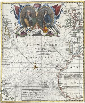
A New Map or Chart of the Western or Atlantic Ocean, with part of Europe Africa and America: Shewing the Course of the Galleons, Flota, and c. to and from the West Indies.
sold
- Digital Map Information
- Suitable for large format printing
- DPI: 300
- File Size: 9.27 MB
- File Type: ZIP / TIFF
- ICC color profile embedded
- Delivered instantly via download link
A fascinating map of the Atlantic Ocean engraved by Emmanuel Bowen in June, 1740 for issue in the June edition of Gentleman's Magazine. Centered on the Azores, this map covers from Labrador and Newfoundland eastward to including all of England and Ireland, Spain, ... (more details)
Map with early American natural history imagery.
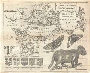
A Plan of the Harbour of Chebucto and Town of Halifax.
sold
- Digital Map Information
- Suitable for large format printing
- DPI: 300
- File Size: 3.65 MB
- File Type: ZIP / TIFF
- ICC color profile embedded
- Delivered instantly via download link
One of the more desirable maps to be issued for Gentleman's Magazine , this is a 1750 map of Halifax Harbor and vicinity, Nova Scotia, with naturalist elements. This map was issued 1 year after Halifax's founding in 1749. Oriented to the west and centered on the ... (more details)
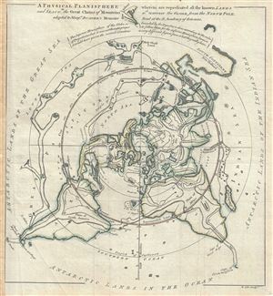
A Physical Planisphere wherein are represented all the known Lands and Seas, w.th the Great Chains of Mountains w.ch traverse the Globe from the North Pole.
sold
- Digital Map Information
- Suitable for large format printing
- Full resolution TIFF file
- ICC color profile embedded
- Delivered instantly via download link
This is a beautiful 1757 Philippe Buache map of the world represented on an unusual polar projection rendered from the North Pole. The map covers from the North Pole Arctic region south beyond Tasmania (Van Diemen's Land) to include parts of New Zealand and even ... (more details)
Britain's Prize in America following the French and Indian War.
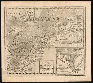
An Accurate Map of the British Empire in Nth. America as settled by the Preliminaries in 1762.
sold
- Digital Map Information
- Suitable for large format printing
- DPI: 600
- File Size: 12.76 MB
- File Type: ZIP / TIFF
- ICC color profile embedded
- Delivered instantly via download link
This scarce, fascinating map of North America east of the Mississippi appeared in the 1762 end-of-year supplement of the Gentleman's Magazine. It revealed, to that magazine's readership, the vast prize of American land that Great Britain stood to gain at the expense of the French in the treaty negotiations then bringing the French and Indian War (1754 - 1763) to a close. (more details)
Buache's fantastic speculative mapping of the undiscovered Antarctic continent.
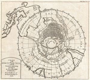
Chart of the Antarctic Polar Circle, with the Countries Adjoining, According to the New Hypothesis of M. Buache. From the Memoirs of the Royal Academy at Paris.
sold
- Digital Map Information
- Suitable for large format printing
- Full resolution TIFF file
- ICC color profile embedded
- Delivered instantly via download link
This is an unusual and highly speculative map of the southern Polar Regions (Antarctic) drawn in 1763 by the scientific geographer M. Buache. A subtle and unusual map that yields more fascinating discoveries the longer one studies it, this chart centers on the ... (more details)
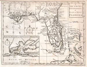
A Map of the New Governments, of East & West Florida.
sold
- Digital Map Information
- Suitable for large format printing
- DPI: 300
- File Size: 1.37 MB
- File Type: ZIP / TIFF
- ICC color profile embedded
- Delivered instantly via download link
Featured here is a rare and important map of Florida issued for Gentleman's Magazine in 1763 to describe the new territories of British Florida. The map depicts the provinces of East and West Florida as they emerged following the Treaty of Paris that ended ... (more details)
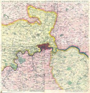
An Accurate Map of the Country Sixteen Miles Round London Drawn and Engrav'd from an Actual Survey.
sold
- Digital Map Information
- Suitable for large format printing
- DPI: 300
- File Size: 6.42 MB
- File Type: ZIP / TIFF
- ICC color profile embedded
- Delivered instantly via download link
This is a rare and unusual c. 1764 Map of London, England and the environs sixteen miles around. Published by Gentleman's Magazine in four separate issues with publisher's instruction on how to bind them into a single map. Covers the London area in ... (more details)
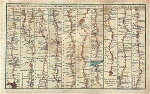
A Map of the Roads from London thro Oxford, Worchester &c. to Aberistwith. The Road from Bristol to Exeter.
sold
- Digital Map Information
- Suitable for large format printing
- DPI: 300
- File Size: 3.57 MB
- File Type: ZIP / TIFF
- ICC color profile embedded
- Delivered instantly via download link
This is a scarce 1765 example of the map of the roads from London to Aberystwyth and from Bristol to Exeter published in the Gentleman's Magazine. Essentially two maps on one sheet, features ten road strip maps through Middlesex, Oxfordshire, ... (more details)
Early American Revolutionary War plan of Boston closely following the Battle of Bunker Hill.
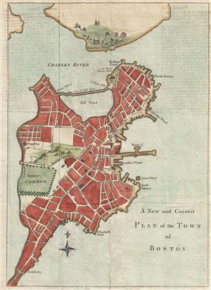
A New and Correct Plan of the Town of Boston.
sold
- Digital Map Information
- Suitable for large format printing
- DPI: 300
- File Size: 3.01 MB
- File Type: ZIP / TIFF
- ICC color profile embedded
- Delivered instantly via download link
An uncommon and attractive 1775 map of Boston issued in the early days of the American Revolutionary War just following the Battle of Bunker Hill. The map covers the original peninsula of Boston as well as the ruins of Charleston just across ... (more details)
An Early, Revolutionary-War era Plan of Boston.
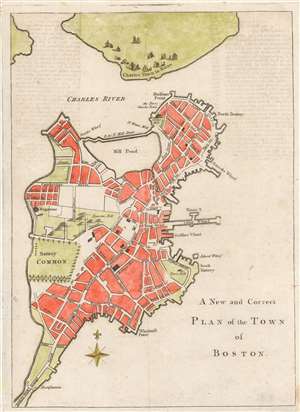
A New and Correct Plan of the Town of Boston.
sold
- Digital Map Information
- Suitable for large format printing
- DPI: 600
- File Size: 3.8 MB
- File Type: ZIP / TIFF
- ICC color profile embedded
- Delivered instantly via download link
An uncommon and attractive 1775 map of Boston issued in the early days of the American Revolutionary War just following the Battle of Bunker Hill. The map covers the original peninsula of Boston as well as the ruins of Charleston just across the river. The plan names streets, including Beacon Street with a topographical representation of Beacon Hill, Newberry Street, and indications of fortifications, batteries, and other landmarks. Major buildings are represented, as are wharfs, including Hancock's Warf, Long Warf, and Griffins Warf, among others. The mill dam is identified. (more details)
Earliest map to name Bunker Hill - reporting the moment troops were preparing for battle.
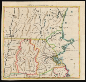
A Map of 100 Miles round Boston.
sold
- Digital Map Information
- Suitable for large format printing
- DPI: 600
- File Size: 10.68 MB
- File Type: ZIP / TIFF
- ICC color profile embedded
- Delivered instantly via download link
This 1775 map of the region surrounding Boston, issued in the early days of the American Revolutionary War, is the earliest printed map to name Bunkers Hill, and was printed before the results of the battle were known. This map appeared astonishingly early, in the June 1775 issue of The Gentleman's Magazine. The issue's contents page includes the following note with respect to this map:
with an accurate Map of the Country One Hundred Miles round Boston, in order to shew the Situation and March of the Troops, as well Provincials as Regulars, which are now within Sight of each other, and are hourly expected to engage.(emphasis ours)So although the map appeared in print just following the battle, it was printed before the outcome, or even the first shot, of the battle was actually reported in England. (more details)