
Mead, Braddock (sold)

Braddock Mead (c. 1688 - 1757), also known as John Green, was an Irish cartographer and map engraver active in London during the middle part of the 18th century. Mead is one of the most interesting and colorful figures in cartography whose louche personal life sharply contrasted with the high standard of his maps. Mead was born in Ireland around 1688 and seems to have come from a good family and received a respectable education. His brother Thomas Mead held the position of Lord Mayor of Dublin in 1757. Braddock Mead left Dublin for London around 1717 where he plunged into vice, subsidizing his cartographic work with hack work and gambling. In 1728 Mead fell in with a plot to defraud a 12 year old Irish heiress, Bridget Reading, of her fortune by kidnapping and marrying her himself. Mead suffered jail time for the crime but was more fortunate than his partner, a fellow Irishman named Kimberly, who was hanged. As a cartographer Mead cannot have exhibited a more antithetical character. He held himself and others to the highest standards of accuracy and scholarship, and issued a call for greater transparency in the field of mapmaking. Mead worked with Ephraim Chambers on the Universal Dictionary, as well as with Cave and Astley in the publication of various travelogues and explorer's journals, notably Astley’s New General Collection of voyages and travels. Eventually he came to work for the publishing house of Thomas Jefferys, who saw through Mead's personal failings to appreciate his cartographic brilliance. Mead has been called the genius behind Jefferys and he seems to have had a hand in the production of many of Jefferys' most important maps. William Cumming notes that Mead
had a number of marked characteristics as a cartographer ... One was his ability to collect, to analyze the value of, and to use a wide variety of sources; these he acknowledged scrupulously on the maps he designed and even more fully in accompanying remarks. Another outstanding characteristic was his intelligent compilation and careful evaluation of reports on latitudes and longitudes used in the construction of his maps, which he also entered in tables on the face of the maps ... Mead's contributions to cartography stand out ... At a time when the quality and the ethics of map production were at a low ebb in England, he vigorously urged and practiced the highest standards; in the making of maps and navigational charts he was in advance of his time. For this he deserves due credit.
First Accurate English Map of Tibet.
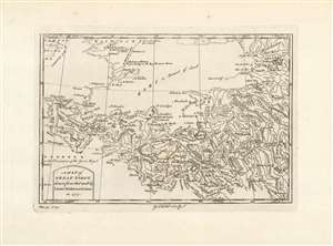
A Map of Great Tibet, drawn from that made by Lama Mathematicians in 1717.
sold
- Digital Map Information
- Suitable for large format printing
- Full resolution TIFF file
- ICC color profile embedded
- Delivered instantly via download link
This is the earliest English map of Tibet, engraved for Braddock Mead's A New General Collection of Voyages and Travels, published under his pseudonym 'John Green' by Thomas Astley in 1747. It is one of the few maps of the region to rely (ultimately) on local sources - although the mapmaker's claim that the map was 'drawn from that made by Lama Mathematicians' does not include the chain of Jesuit missionaries and French cartographers linking the 'Lama Mathematicians' to the 'English engraver'. The map covers an area from northern India (Delhi is shown) to encompass the Gobi Desert and as far as Kashgar. The map includes Lake Kokonor in the Qinghai Province of China, and embraces what is now the Xinjiang Uyghur Autonomous Region. The Himalaya Mountains of Tibet appear pictorially, but the map is rich in place names and rivers, including several rivers disappearing into the endoheiric basins of the Gobi. (more details)
Frontier of the French and Indian War.
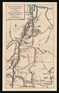
The Country between Crown Point and Albany being the Great Pass from the English to the French Settlements in North America.
sold
- Digital Map Information
- Suitable for large format printing
- DPI: 600
- File Size: 4.83 MB
- File Type: ZIP / TIFF
- ICC color profile embedded
- Delivered instantly via download link
This is a rare 1858 map of a key theatre of the French and Indian War, engraved by Thomas Phinn in Edinburgh to satisfy readers hungry for news. Although of broader scope, it is remarkable in pre-dating the famous Brasier map of Lakes Champlain and George, the earliest separate map specifically of those lakes. The Brasier surveys began after the publication of the present map. (more details)
The most important and influential 18th century Colonal Era map of New England.
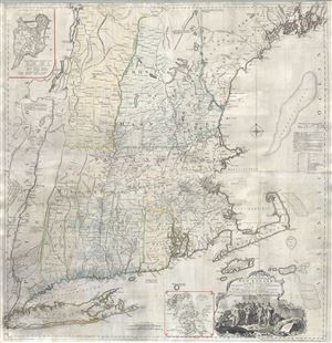
A Map of the most Inhabited part of New England containing the Provinces of Massachusets Bay and New Hampshire, with the Colonies of Connecticut and Rhode Island, divided into Counties and Townships: The whole composed form Actual Surveys and its Situation adjusted by Astronomical Observations.
sold
- Digital Map Information
- Suitable for large format printing
- Full resolution TIFF file
- ICC color profile embedded
- Delivered instantly via download link
A highly significant map, this is the 1774 'Jefferys' Map' of the Most Inhabited Part of New england . Centered on the Massachusetts Bay Colony, this map covers from Long Island to Lake Champlain and from the Hudson River to Cape Cod and Kennebec Bay, Maine. ... (more details)
Most important and influential 18th century Colonial Era map of New England.
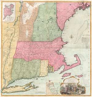
A Map of the most Inhabited part of New England containing the Provinces of Massachusets Bay and New Hampshire, with the Colonies of Connecticut and Rhode Island, divided into Counties and Townships: The whole composed form Actual Surveys and its Situation adjusted by Astronomical Observations.
sold
- Digital Map Information
- Suitable for large format printing
- Full resolution TIFF file
- ICC color profile embedded
- Delivered instantly via download link
A highly significant map, this is the 1774 'Jefferys' Map' of the Most Inhabited Part of New England. Centered on the Massachusetts Bay Colony, this map covers from Long Island to Lake Champlain and from the Hudson River to Cape Cod and Kennebec Bay, Maine. There is an inset of Boston in the upper left corner and another of Boston Harbor near the cartouche in the lower right quadrant. This scarce map was drawn by Braddock Mead (a.k.a. John Green) and published by Thomas Jefferys. It was first published in 1755 and went through at least six subsequent revisions, the present example being the third edition issued in 1774 for Thomas Jefferys' American Atlas. From the publication of the American Atlas onwards, this significant map, the most important in the Atlas, became known as the 'Jefferys Map'. (more details)
The most important and influential 18th century Colonial Era map of New England.
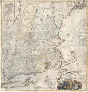
A Map of the most Inhabited part of New England containing the Provinces of Massachusets Bay and New Hampshire, with the Colonies of Connecticut and Rhode Island, divided into Counties and Townships: The whole composed form Actual Surveys and its Situation adjusted by Astronomical Observations.
sold
- Digital Map Information
- Suitable for large format printing
- Full resolution TIFF file
- ICC color profile embedded
- Delivered instantly via download link
A highly significant map, this is the 1774 'Jefferys' Map' of the Most Inhabited Part of New england . Centered on the Massachusetts Bay Colony, this map covers from Long Island to Lake Champlain and from the Hudson River to Cape Cod and Kennebec Bay, Maine. ... (more details)
The most important and influential 18th century Colonial Era map of New England.
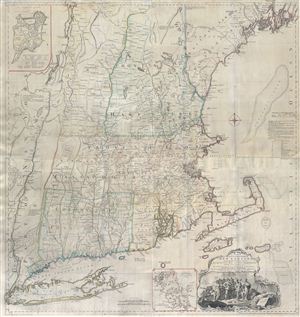
A Map of the most Inhabited part of New England containing the Provinces of Massachusets Bay and New Hampshire, with the Colonies of Connecticut and Rhode Island, divided into Counties and Townships: The whole composed form Actual Surveys and its Situation adjusted by Astronomical Observations.
sold
- Digital Map Information
- Suitable for large format printing
- Full resolution TIFF file
- ICC color profile embedded
- Delivered instantly via download link
A highly significant map, this is the 1774 'Jefferys' Map' of the Most Inhabited Part of New england . Centered on the Massachusetts Bay Colony, this map covers from Long Island to Lake Champlain and from the Hudson River to Cape Cod and Kennebec Bay, Maine. ... (more details)
The most important and influential 18th century Colonial Era map of New England.
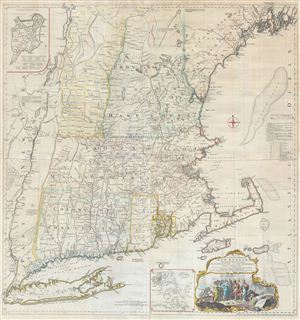
A Map of the most Inhabited part of New England containing the Provinces of Massachusets Bay and New Hampshire, with the Colonies of Connecticut and Rhode Island, divided into Counties and Townships: The whole composed form Actual Surveys and its Situation adjusted by Astronomical Observations.
sold
- Digital Map Information
- Suitable for large format printing
- Full resolution TIFF file
- ICC color profile embedded
- Delivered instantly via download link
A highly significant map, this is the 1774 'Jefferys' Map' of the Most Inhabited Part of New england . Centered on the Massachusetts Bay Colony, this map covers from Long Island to Lake Champlain and from the Hudson River to Cape Cod and Kennebec Bay, Maine. ... (more details)
Remarkable map showing Alaska as an Island.
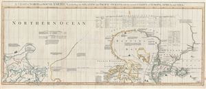
A Chart of North and South America, including the Atlantic and Pacific Oceans, with the nearest Coasts of Europe, Africa, and Asia. Chart containing part of the Icy Sea with the adjacent Coast of Asia and America. Chart comprizing Greenland with the Countries and Islands about Baffins Bay and part of Hudsons Bay.
sold
- Digital Map Information
- Suitable for large format printing
- DPI: 300
- File Size: 28.3 MB
- File Type: ZIP / TIFF
- ICC color profile embedded
- Delivered instantly via download link
A wonderful 1775 map of the Arctic regions of the Western Hemisphere by John Green or Braddock Mead. Focusing on Alaska (Bering Strait) and the Canadian Arctic, map covers from the Sea of Okhotsk (Penschinaska Guba) to Iceland and the east coast of Greenland; ... (more details)
Revelatory map of the Americas.
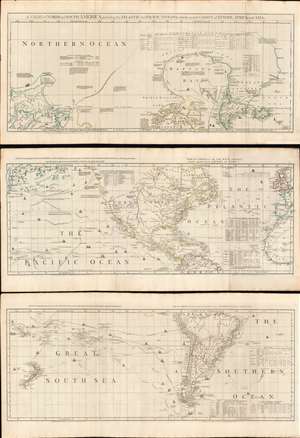
A Chart of North and South America, including the Atlantic and Pacific Oceans, with the nearest Coasts of Europe, Africa, and Asia.
sold
- Digital Map Information
- Suitable for large format printing
- Full resolution TIFF file
- ICC color profile embedded
- Delivered instantly via download link
A wonderful 1775 map of the Americas or Western Hemisphere by John Green, also known as Braddock Mead. The map in fact consists of three related maps covering, from top: Canada and the Arctic; the modern day United States, Central America, and the West Indies; and South America. The map is a masterpiece of late 18th century cartography by one of the least understood and most controversial cartographers of his age. Mead composed the map in protest to what he believed to be the flagrantly spurious and irresponsible speculative cartography of Frenchmen Joseph-Nicolas De l'Isle (1688 - 1768) and Phillipe Buache (1700 - 1773). (more details)
Revolutionary War Era Map of Cape Cod and Boston Harbor with dramatic cartouche.
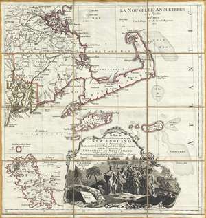
A Map of the most Inhabited part of New England containing the Provinces of Massachusets Bay and New Hampshire, with the Colonies of Connecticut and Rhode Island, divided into Counties and Townships: The whole composed form Actual Surveys and its Situation adjusted by Astronomical Observations.
sold
- Digital Map Information
- Suitable for large format printing
- Full resolution TIFF file
- ICC color profile embedded
- Delivered instantly via download link
A dramatic 1777 Braddock Mead and Le Rouge map of Cape Cod, Nantucket, Martha's Vineyard and Boston Bay. The map covers from Boston to Martha's Vineyard and from Narragansett Bay to Crab Bank and the Nantucket Shoals. This beautiful dissected map is actually ... (more details)