
Seiban Printing Co. (sold) (精版印刷株式會社)

Seiban Printing Co. (精版印刷株式會社; fl. c. 1925 - 1945) was an Osaka-based publisher in the early Showa period. A number of contemporaneous publishing houses used Seiban (or Seihan) in their name (帝国精版印刷, 京都精版印刷社, 日本精版印刷), but were evidently distinct from this publishing house, which specialized in producing maps of the Japanese Empire (such as Manchukuo and occupied areas of China), often for the Osaka Mainchi Shimbun. The company published its own brief history in English in 1929 (A brief history of the Seihan Printing Company Limited, OCLC 843142406), suggesting that the company had already existed for some time by that point.
AKA: 精版印刷株式會社
The Earthquake that Transformed Tokyo.
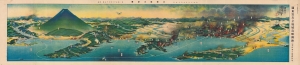
關東震災全地域鳥瞰圖繪 / [Bird's-eye View of the Entire Area of the Kanto Earthquake Disaster].
sold
- Digital Map Information
- Suitable for large format printing
- Full resolution TIFF file
- ICC color profile embedded
- Delivered instantly via download link
This is a rare, poignant bird's-eye view of Tokyo in the aftermath of the 1923 Great Kanto Earthquake by master painter-cartographer Yoshida Hatsusaburō. Coverage includes Tokyo, Yokohama, Mt. Fuji, and surrounding areas. This view was printed and distributed in 1924 (Taisho 13), just after the one-year anniversary of the disaster by the Osaka Mainichi Shimbun and is a fascinating record of both commemoration and reconstruction. (more details)
A gorgeous view of the Japanese home islands.
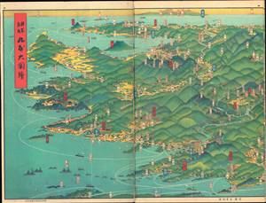
日本鳥瞰 大日本パノラマ大圖繪張 / [Bird's Eye View of Japan - Japan Panorama Foldout Map].
sold
- Digital Map Information
- Suitable for large format printing
- Full resolution TIFF file
- ICC color profile embedded
- Delivered instantly via download link
This is a beautiful 1927 panoramic view of Japan drawn by Yoshida Hatsusaburō and published by the Osaka Mainichi Shimbun. The view is published in atlas format, with pages printed on both sides. It is divided into three sections, each consisting of six pages, covering the entirety of Kyūshū, Honshū, and Shikoku. (more details)
Manchukuo, just prior to its formal establishment.
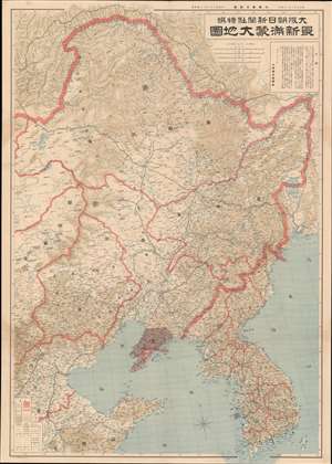
最新满蒙大地圖 / [Latest Map of Manchuria and Mongolia].
sold
- Digital Map Information
- Suitable for large format printing
- File Size: 58.99 MB
- File Type: ZIP / TIFF
- ICC color profile embedded
- Delivered instantly via download link
This is a rare 1932 map of Manchuria, including parts of Mongolia and northern China, published in the Osaka Asahi Shimbun (大阪朝日新聞) to mark the founding of the Japanese puppet state of Manchukuo. Japan's de facto colony was massive, more than double the land area of the Japanese home islands, and served as a frontier rich in resources and opportunity for the land scarce, resource-starved, overpopulated home islands. Therefore, this map was meant to familiarize the readers with this vast new territory but also advertise it as a destination for capital and settlers. (more details)
Japan's growing empire on the eve of World War II.
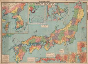
最新大日本地圖 / [Latest Map of Japan].
sold
- Digital Map Information
- Suitable for large format printing
- File Size: 90.24 MB
- File Type: ZIP / TIFF
- ICC color profile embedded
- Delivered instantly via download link
This is a large 1933 map of Japan (including Korea, Taiwan, Hokkaido, the Ryukyus, and other colonial possessions) published as an addendum to the Osaka Asahi Shimbun (大阪朝日新聞). It provides a great deal of geographic and economic information about the different parts of the Japanese Empire on the eve of World War II, just as the Japanese military was embarking on new conquests that would eventually lead to the destruction of the empire. (more details)
Military and economic power on the eve of World War II.
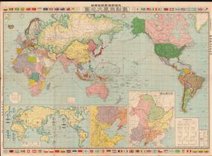
最新世界大地圖 / [Latest World Map].
sold
- Digital Map Information
- Suitable for large format printing
- File Size: 76.69 MB
- File Type: ZIP / TIFF
- ICC color profile embedded
- Delivered instantly via download link
This is a 1933 world map published by the Osaka Asahi Shimbun in the early phase of the Second Sino-Japanese War, an antecedent to and later a theater of World War II. The global tensions that would define World War II are evident here, particularly in the inset map at bottom-left showing the relative military strength of major powers. (more details)
Military and economic power on the eve of World War II.
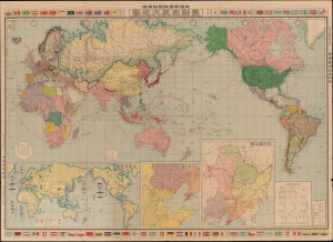
最新世界大地圖 / [Latest World Map].
sold
- Digital Map Information
- Suitable for large format printing
- File Size: 77.29 MB
- File Type: ZIP / TIFF
- ICC color profile embedded
- Delivered instantly via download link
This is a 1933 world map published by the Osaka Asahi Shimbun in the early phase of the Second Sino-Japanese War (1937 - 1845), an antecedent to and later a theater of World War II (1939 - 1945). The global tensions that would define World War II are evident here, particularly in the inset map at bottom-left showing the relative military strength of major powers. (more details)
Japan's Expanding Empire on the Eve of the Second-Sino Japanese War.
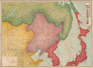
日滿露支交通國境大地圖 / [Map of Transportation and National Borders of Japan, Manchukuo, the Soviet Union, and China].
sold
- Digital Map Information
- Suitable for large format printing
- File Size: 92.59 MB
- File Type: ZIP / TIFF
- ICC color profile embedded
- Delivered instantly via download link
This is a large 1935 map of Northeast Asia (Japan, Korea, Manchuria, northern China, Mongolia, Siberia) that appeared in the Japanese newspaper, Osaka Mainichi Shimbun. It is designed to highlight transportation and communication lines connecting Japan's empire at a time when the empire was expanding and Japan's domestic politics were moving towards militarism. (more details)
The start of WWII in Europe, as seen from Japan.
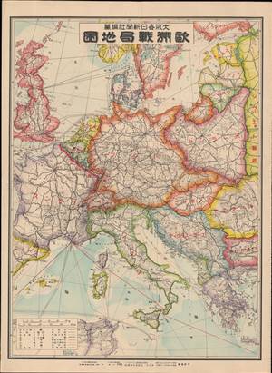
歐洲戰局地圖 / [Map of the War Situation in Europe].
sold
- Digital Map Information
- Suitable for large format printing
- File Size: 20.17 MB
- File Type: ZIP / TIFF
- ICC color profile embedded
- Delivered instantly via download link
This is a September 1939 Japanese map of Europe soon after Nazi Germany's invasion of Poland at the start of World War II (1939 - 1945). It appeared in the Osaka Mainichi Shimbun, one of the leading newspapers in Japan at the time. The map is one of only a few Japanese war-time maps to focus on the European Theater - a are of great interest to Japanese citizenry despite being on the opposite side of the world - see below. (more details)
One of World War II's forgotten fronts.
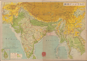
ビルマ - インド詳圖 / [Detailed Map of Burma and India].
sold
- Digital Map Information
- Suitable for large format printing
- Full resolution TIFF file
- ICC color profile embedded
- Delivered instantly via download link
This is a 1942 Asahi Shimbun Japanese map of Burma, India, and surrounding territories, made in the context of the Burma Campaign of World War II (1939 - 1945). When this map was published, Japanese forces were advancing northwards in Burma after having rapidly conquered the capital, Rangoon. It was issued to celebrate the victory and promote the war effort on the home front. (more details)