
Tanner, Henry Schenck

Henry Schenck Tanner (1786 - May 18, 1858) was one of the preeminent American map engravers and publishers of the early 19th century - what is considered to be the "Golden Age of American Map Publishing". Born in New York City but based in Philadelphia, Tanner's forty plus year career was almost entirely focused on cartographic work. His earliest map work appears in conjunction with another important map publisher, John Melish. Early in his career, Tanner partnered with his brother Benjamin, to engrave extensively for Melish as well as other Philadelphia publishers including Lucas Fielding (Baltimore), A. Bourne, Jason Torey, Samuel Harrison, and Samuel Lewis, among others. In 1818 Tanner convinced his fellow publishers and partners to finance the compilation of a New American Atlas. The atlas was sold by subscription and slowly emerged between 1819 and 1823. The New American Atlas, possibly the pinnacle of 19th century American cartography and was commended in its day as "one of the most splendid works of the kind ever executed in this country". It was subsequently republished in several updated editions until about 1839. Tanner had by this time become the most active and influential map publisher in the United States. Around 1832, recognizing the market for a less cost prohibitive atlas, Tanner began work on the smaller format New Universal Atlas. This popular and important atlas went through numerous editions before being bought out by Carey and Hart, and then, in 1846, by S. A. Mitchell, who would rise to become the preeminent publisher of the next generation. In addition to these important atlases, Tanner also issued numerous extremely important and influential travelers guides, state maps, wall maps, and pocket maps. He should not be confused with his brother, also an America map engraver, the New Yorker Benjamin Tanner.
A first edition!
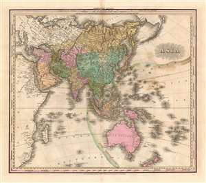
Asia.
$750.00
Acquire
- Digital Map Information
- Suitable for large format printing
- DPI: 600
- File Size: 21.58 MB
- File Type: ZIP / TIFF
- ICC color profile embedded
- Delivered instantly via download link
This is an 1823 first edition Henry Shenk Tanner map of Asia. The map depicts from continental Europe and Africa (though both are uncolored) to Alaska and from the Arctic Ocean to Australia, South Africa, and the Southern Ocean. A few cartographic oddities create intriguing questions. One such abnormality is Hokkaido not being included in the Islands of Japan. Another concerns Luzon, in the Philippines, which is bisected in such a way that it resembles two peninsulas - probably in an attempt to represent the Cagayan River. Myriad locations throughout the region are identified, including Singapore, Persia, Tibet (Thibet), and Nepal (Napaul). The coasts, which had been known to European traders and explorers for hundreds of years, exhibit the most detail, while some inland regions, such as the Gobi Desert, New Guinea, and most of Australia, bear very little detail. (more details)
Transitional state of H.S. Tanner's Kentucky and Tennessee.
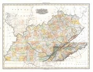
Kentucky and Tennessee by H. S. Tanner.
$1,500.00
Acquire
- Digital Map Information
- Suitable for large format printing
- DPI: 600
- File Size: 28.2 MB
- File Type: ZIP / TIFF
- ICC color profile embedded
- Delivered instantly via download link
This is a rare transitional state of Henry S. Tanner's 1823 map of Kentucky and Tennessee. The map captures the creation of Wood Lake following the New Madrid Earthquakes. (more details)
First state of this rare, important map.
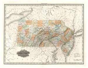
Map of Pennsylvania and New Jersey by H. S. Tanner.
$1,500.00
Acquire
- Digital Map Information
- Suitable for large format printing
- DPI: 600
- File Size: 32.45 MB
- File Type: ZIP / TIFF
- ICC color profile embedded
- Delivered instantly via download link
The rare first state of H. S. Tanner's 1823 map of Pennsylvania and New Jersey. This elephant folio map covers all of Pennsylvania and New Jersey in detail, as well as sketching in the adjacent parts of New York, Ohio, Virginia, and Maryland. The map shows rivers, canals, cities, towns and roadways. Topography is indicated with hachure. In particular, Pennsylvania's early industrial history is captured here, showing sawmills, iron mines and iron works, salt and limestone mines, and even coal mines in Clearfield and Centre Counties (including specifically the Allegheny Coal Company). (more details)
Rare Transitional State Chronicling the Aftermath of the 1818 Delaware's Cession.
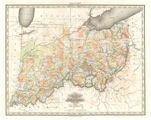
Ohio and Indiana By H.S. Tanner.
$2,000.00
Acquire
- Digital Map Information
- Suitable for large format printing
- DPI: 600
- File Size: 30.04 MB
- File Type: ZIP / TIFF
- ICC color profile embedded
- Delivered instantly via download link
A rare and important map of Ohio and Indiana by Henry S. Tanner, in a transitional state between the 1823 and 1825 editions of his New American Atlas. This elephant folio map covers all of Ohio and Indiana in detail, as well as sketching in adjacent parts of Michigan, Illinois, Kentucky, Virginia and Pennsylvania. The map is a strong example of Tanner's superb engraving, showing rivers, topography by hachure, cities, towns and roadways. (more details)
Includes an intriguing depiction of the Philippines with exaggerated mapping of the Cagayan River!
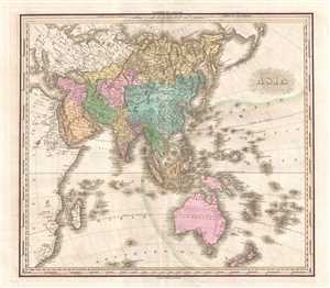
Asia.
$750.00
Acquire
- Digital Map Information
- Suitable for large format printing
- DPI: 300
- File Size: 11.18 MB
- File Type: ZIP / TIFF
- ICC color profile embedded
- Delivered instantly via download link
This is an 1825 Henry Shenk Tanner map of Asia. The map depicts from continental Europe and Africa (though both are uncolored) to Alaska and from the Arctic Ocean to Australia, South Africa, and the Southern Ocean. A few intriguing details are present here, ... (more details)
Scarce edition of Tanner's New England.
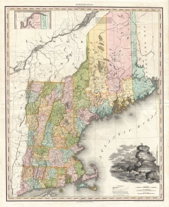
Map of the States of Maine New Hampshire Vermont Massachusetts Connecticut and Rhode Island.
$1,200.00
Acquire
- Digital Map Information
- Suitable for large format printing
- DPI: 300
- File Size: 23.22 MB
- File Type: ZIP / TIFF
- ICC color profile embedded
- Delivered instantly via download link
This is an 1825 Henry S. Tanner map of New England. This map, like others from Tanner's New American Atlas, is considered an apex achievement of the 'Golden Age of American Map Publishing.' It features an intriguing early Maine county configuration. (more details)
Missouri Territory and the 'Oregon Question'.
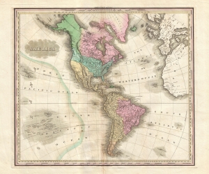
America.
$950.00
Acquire
- Digital Map Information
- Suitable for large format printing
- DPI: 300
- File Size: 12.27 MB
- File Type: ZIP / TIFF
- ICC color profile embedded
- Delivered instantly via download link
This is an 1825 Henry Shenk Tanner map of the Americas and the Western Hemisphere. (more details)
An important perspective on American Indian territory in Ohio and Indiana before the Treaty of Mississinewas forced the Miami off their traditional lands.
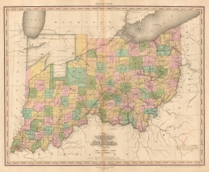
Ohio and Indiana By H.S. Tanner.
$1,250.00
Acquire
- Digital Map Information
- Suitable for large format printing
- Full resolution TIFF file
- ICC color profile embedded
- Delivered instantly via download link
A rare and important map of Ohio and Indiana by H. S. Tanner. American Indian lands constitute most of modern-day northern Indiana, which would change only a year later with the signing of the Treaty of Mississinewas. (more details)
Landmark map of North America.
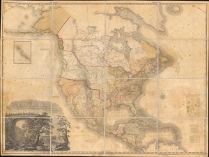
A Map of North America Constructed According to the Latest Information by H. S. Tanner.
$6,500.00
Acquire
- Digital Map Information
- Suitable for large format printing
- File Size: 172.54 MB
- File Type: ZIP / TIFF
- ICC color profile embedded
- Delivered instantly via download link
An example of Henry Schenk Tanner's 1825 landmark map of North America, considered to be the most important 19th-century map of North America. Revolutionary in countless ways, this is the most accurate map of North America the world of 1825 had yet seen, particularly the little-understood western parts. The task before Tanner in assembling this map, piecing together the cartography of an unknown country from piecemeal, often unreliable reports, was monumental. Tanner draws on Aaron Arrowsmith, Lewis and Clark, Alexander von Humboldt, Zebulon Pike, Stephen Harriman Long, Daniel Williams Harmon, George Vancouver, and others. (more details)
A Pacified Frontier.
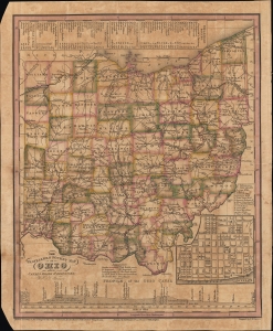
The Travellers Pocket Map of Ohio with its canals, roads and distances. / Ohio Traveller.
$1,200.00
Acquire
- Digital Map Information
- Suitable for large format printing
- File Size: 10 MB
- File Type: ZIP / TIFF
- ICC color profile embedded
- Delivered instantly via download link
This is a scarce 1830 pocket map of Ohio by Henry Schenck Tanner and engraved by Edward B. Dawson. It presents the state during a period of rapid growth after the War of 1812, as settlers arrived in large numbers to settle the pacified frontier. (more details)
Early Appearance of the Wabash and Erie Canal.
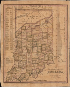
The Travellers Pocket Map of Indiana with its roads and distances. / Indiana Traveller.
$1,200.00
Acquire
- Digital Map Information
- Suitable for large format printing
- File Size: 8.78 MB
- File Type: ZIP / TIFF
- ICC color profile embedded
- Delivered instantly via download link
This is a scarce 1831 pocket map of Indiana prepared by Henry Schenck Tanner and engraved by John Knight. It presents the state as its population was growing rapidly in the wake of statehood and several wars against Native Americans, particularly Tecumseh's Confederacy, which opened most of the state's territory up to settlement. (more details)
The Great Metropolis.
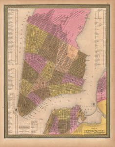
City of New York.
$550.00
Acquire
- Digital Map Information
- Suitable for large format printing
- Full resolution TIFF file
- ICC color profile embedded
- Delivered instantly via download link
This is Samuel Augustus Mitchell's hand-colored 1848 map of New York City. It reflects the city in a period of rapid development, defined by immigration and industrialization. (more details)