
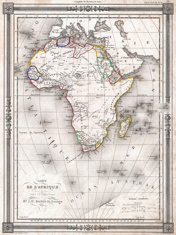
Carte de L'Afrique dressee ET dessinee sous la Direction de Mr. J. G. Barbie du Bocage.
sold
- Digital Map Information
- Suitable for large format printing
- DPI: 300
- File Size: 4.96 MB
- File Type: ZIP / TIFF
- ICC color profile embedded
- Delivered instantly via download link
An uncommon and extremely attractive 1852 map of Africa by J. G. Barbie du Bocage. Shows the continent of Africa situated high on the page. Labels the costal kingdoms and colonies including Zanzibar, Biafra, Senegabia, Algeria, Maroco, Abyssinia, Nubia, the Cape ... (more details)
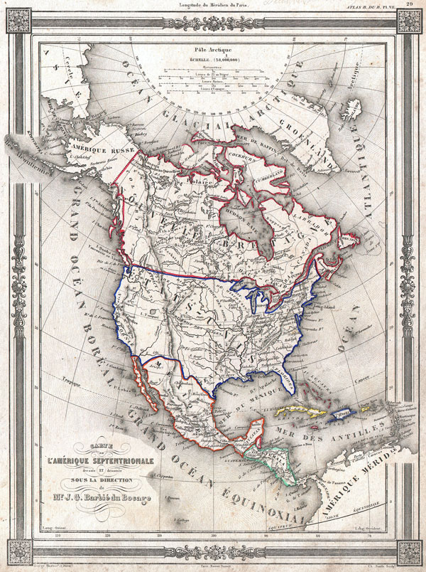
Carte de L'Amerique Septentrionale dresse ET dessinee sous laDirection de Mr. J. G. Barbie du Bocage.
sold
- Digital Map Information
- Suitable for large format printing
- DPI: 300
- File Size: 5.41 MB
- File Type: ZIP / TIFF
- ICC color profile embedded
- Delivered instantly via download link
An uncommon and extremely attractive 1852 map of North America by J. G. Barbie du Bocage. Depicts all of North America from the Arctic Circle to the northern part of South America. The United States is shown shortly after the acquisition of Texas and Upper ... (more details)

Mexique par Th. Duvotenay.
sold
- Digital Map Information
- Suitable for large format printing
- DPI: 300
- File Size: 4.93 MB
- File Type: ZIP / TIFF
- ICC color profile embedded
- Delivered instantly via download link
An uncommon and extremely attractive 1852 map of the Mexico by Th. Dovotenay. Includes all of modern day Mexico as well as Texas and the territories (Upper California) claimed by Mexico prior to the 1849 Treaty of Guadaloupe-Hildago. Shows the Mexico – ... (more details)
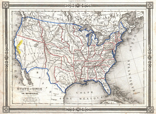
Etats-Unis par Th. Duvotenay.
sold
- Digital Map Information
- Suitable for large format printing
- DPI: 300
- File Size: 4.99 MB
- File Type: ZIP / TIFF
- ICC color profile embedded
- Delivered instantly via download link
An uncommon and extremely attractive 1852 map of the United States by Th. Dovotenay. Depicts the United States at the height of the California Gold Rush and shortly after the annexation of Texas. While most of the eastern United States is well defined the ... (more details)
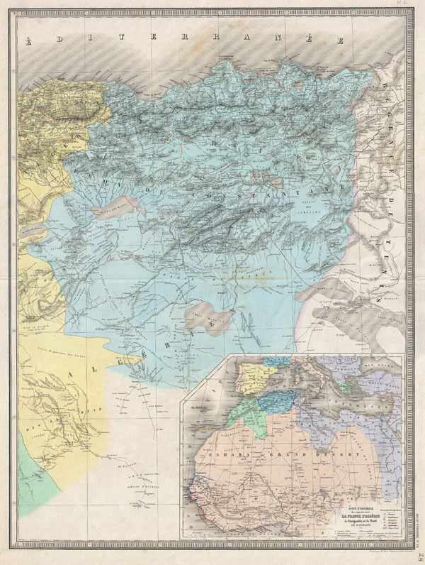
Untitled.
sold
- Digital Map Information
- Suitable for large format printing
- File Size: 22.38 MB
- File Type: ZIP / TIFF
- ICC color profile embedded
- Delivered instantly via download link
An extremely attractive and monumentally proportioned 1857 map of Constantine, Algeria by the French cartographer A. H. Dufour. Shows roads, rivers, caravan routes, cities, and topographical features. A large inset in the lower right quadrant details ... (more details)
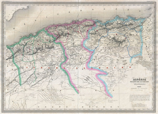
Algerie.
sold
- Digital Map Information
- Suitable for large format printing
- File Size: 32.42 MB
- File Type: ZIP / TIFF
- ICC color profile embedded
- Delivered instantly via download link
An extremely attractive and monumentally proportioned 1857 map of Algeria by the French cartographer A. H. Dufour. Algeria is depicted divided into the administrative districts of Oran, Alger and Constantine. Shows roads, rivers, caravan routes, ... (more details)
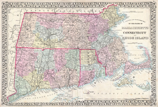
County and Township Map of the States of Massachusetts Connecticut and Rhode Island.
sold
- Digital Map Information
- Suitable for large format printing
- File Size: 14.69 MB
- File Type: ZIP / TIFF
- ICC color profile embedded
- Delivered instantly via download link
A beautiful example of S. A. Mitchell Jr.'s 1873 map of Massachusetts, Connecticut and Rhode Island. Shows cities, towns, railroads and roadways with color coding according to district. Also includes both Martha Vineyard and Nantucket. Features ... (more details)

Sketch F No. 3 Showing the progress of the Survey of Cedar Keys, Bahia Honda, Key Biscayne Key West & Dry Tortugas In Section No. VI 1849 - 53.
sold
- Digital Map Information
- Suitable for large format printing
- DPI: 300
- File Size: 3.45 MB
- File Type: ZIP / TIFF
- ICC color profile embedded
- Delivered instantly via download link
This is an 1853 triangulation chart of Biscayne Bay, Key West, Bahia Honda, the Cedar keys and the Dry Tortugas produced by the U.S. Coast Survey. Essentially five maps compiled onto a single sheet. Upper left map focuses on Key West, Florida, ... (more details)

Illinois.
sold
- Digital Map Information
- Suitable for large format printing
- File Size: 9.04 MB
- File Type: ZIP / TIFF
- ICC color profile embedded
- Delivered instantly via download link
This is the 1855 issue of J. H. Colton's map of Illinois. Depicts the state of Illinois along with parts of neighboring Iowa, Missouri, Indiana and Kentucky. Color coded according to county. Shows major roadways and railroads as well as ... (more details)

Map Showing the Work of The National Antarctic Expedition. 1902 - 3 - 4.
sold
- Digital Map Information
- Suitable for large format printing
- File Size: 7.67 MB
- File Type: ZIP / TIFF
- ICC color profile embedded
- Delivered instantly via download link
This unusual map details the explorations of the British National Antarctic Expedition. The British National Antarctic Expedition, also known as the Discovery Expedition, (1901 – 1904) was the first official British Exploration of the ... (more details)

Johnson's Australia and East Indies.
sold
- Digital Map Information
- Suitable for large format printing
- File Size: 19.4 MB
- File Type: ZIP / TIFF
- ICC color profile embedded
- Delivered instantly via download link
This is A. J. Johnson's 1870 map of Australia, the East Indies and Southeast Asia. Covers from Modern day Thailand and Vietnam south to include all of the East Indies, the Philippines, New Guinea and the continent of Australia. Offers ... (more details)
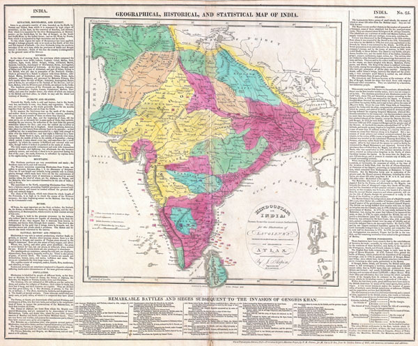
Geographical, Historical, and Statisitcal Map of India / Hindoostan; or India
sold
- Digital Map Information
- Suitable for large format printing
- DPI: 300
- File Size: 13.76 MB
- File Type: ZIP / TIFF
- ICC color profile embedded
- Delivered instantly via download link
This is an attractive 1821 map of India issued by Matthew Carey. Covers the subcontinent from Tibet Kashmir south to Sri Lanka or Ceylon. Color coded according to territory with British possessions or dependencies in red. Shows the ... (more details)

(Sketch H No. 6) Preliminary Chart of Ship Island Shoal Louisiana.
sold
- Digital Map Information
- Suitable for large format printing
- DPI: 300
- File Size: 7.23 MB
- File Type: ZIP / TIFF
- ICC color profile embedded
- Delivered instantly via download link
An attractive example of the U.S. Coast Survey Map of Louisiana's Ship Island Shoal. Details part Isle Derniere (Ast Island) and Caillon Bay. Shows Ast Station and the luxurious Ocean Club Hotel, both of which were destroyed in the ... (more details)

Germany General Map.
sold
- Digital Map Information
- Suitable for large format printing
- DPI: 300
- File Size: 10 MB
- File Type: ZIP / TIFF
- ICC color profile embedded
- Delivered instantly via download link
This is the Society for Diffusion of Useful Knowledge's attractive 1840 map of Germany. Covers Germany from the North Sea to Prussia and as far south as Switzerland and Hungary. As with most S.D.U.K offers superb detail and color ... (more details)

The 'Times of India' Map of Bombay
sold
- Digital Map Information
- Suitable for large format printing
- File Size: 42.65 MB
- File Type: ZIP / TIFF
- ICC color profile embedded
- Delivered instantly via download link
This is an extremely scarce and attractive map of Bombay, India issued c. 1895 by the Times of India . Covers the Island of Bombay in extraordinary detail noting numerous individual buildings, rail lines, city parks, and streets. ... (more details)
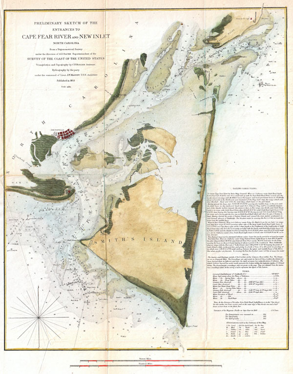
Preliminary Chart of the Entrances to Cape Fear River and New Inlet North Carolina.
sold
- Digital Map Information
- Suitable for large format printing
- DPI: 300
- File Size: 8.77 MB
- File Type: ZIP / TIFF
- ICC color profile embedded
- Delivered instantly via download link
One of the more striking examples of the U.S. Coast Survey Map of North Carolina's Cape Fear and Cape Fear River. Extends from Federal Point south to the top of Cape Fear and then west past Smithville and Fort Caswell to Oak ... (more details)

A Plat Exhibiting the State of the Surveys in the State of Florida with References.
sold
- Digital Map Information
- Suitable for large format printing
- DPI: 300
- File Size: 15.98 MB
- File Type: ZIP / TIFF
- ICC color profile embedded
- Delivered instantly via download link
An extremely rare variant state of the 1849 Land Survey Map of Florida. Geographically this map corresponds to the 1848 Butler issue of this map, but bears the Putnam imprint and 1849 date overprinting an earlier date of ... (more details)

Agricultural Map of the State of New-York.
sold
- Digital Map Information
- Suitable for large format printing
- DPI: 300
- File Size: 17.64 MB
- File Type: ZIP / TIFF
- ICC color profile embedded
- Delivered instantly via download link
This is a rarely seen 1846 thematic of New York by E. Emmons and G. & W. Endicott. Divides the state of New York, as well as neighboring states of Connecticut, Massachusetts, New Hampshire and Vermont, into six distinct ... (more details)
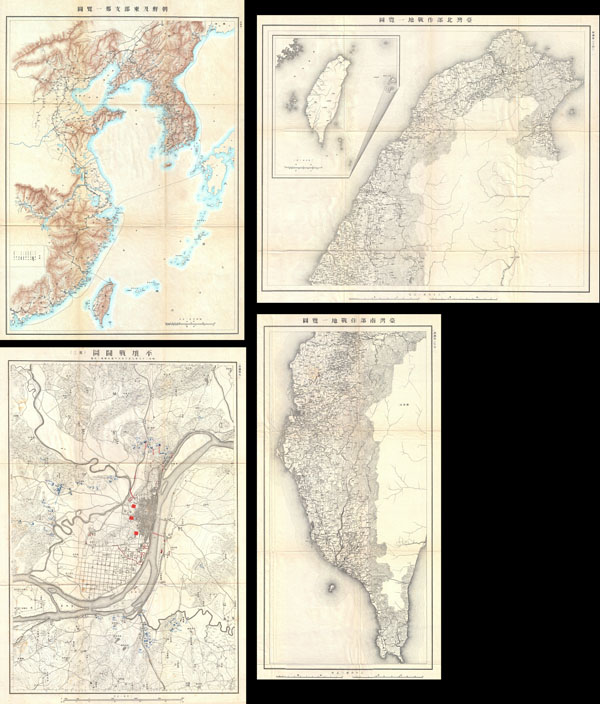
1895 Sino-Japanese War Report
sold
This is a rarely seen Japanese atlas created in the early 1900s to illustrate the first Sino-Japanese War. The First Sino-Japanese War (1 August 1894 – 17 April 1895) was fought between Qing Dynasty China and Meiji ... (more details)

Double Stars and Clusters.
sold
- Digital Map Information
- Suitable for large format printing
- File Size: 6.08 MB
- File Type: ZIP / TIFF
- ICC color profile embedded
- Delivered instantly via download link
This rare chart of star clusters and double stars was engraved W. G. Evans of New York for Burritt's Atlas to Illustrate the Geography of the Heavens . Notes important clusters and star systems including the ... (more details)