

Clusters, Nebulae, and Comets.
sold
- Digital Map Information
- Suitable for large format printing
- File Size: 6.91 MB
- File Type: ZIP / TIFF
- ICC color profile embedded
- Delivered instantly via download link
This is an 1856 E. H. Burritt chart of comets, star clusters, and nebulae. Several important comets recorded in the previous 300 years appear, including the Comet of 1689, the Comet of 1744, The Great Comet of 1680, the Great Comet of 1811, Halley's Comet, the Great Comet of 1819, and the Comet of 1843. Other celestial bodies that are illustrated include the well-known nebulas the Horse Shoe Nebula, the Spiral Nebula, and the Dumb Bell Nebula. (more details)

The Constellations: June, May April.
sold
- Digital Map Information
- Suitable for large format printing
- File Size: 8.76 MB
- File Type: ZIP / TIFF
- ICC color profile embedded
- Delivered instantly via download link
This rare hand colored map of the stars was engraved W. G. Evans of New York for Burritt's 1856 edition of the Atlas to Illustrate the Geography of the Heavens. It represents the Northern night sky in the months of June, May, and April. Constellations are drawn in ... (more details)
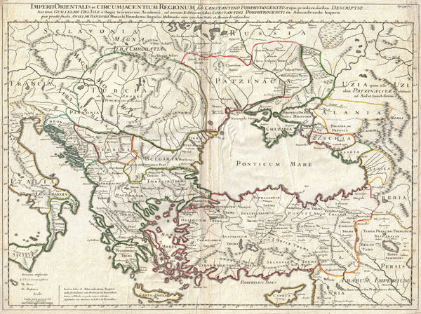
Imperii Orientalis et Circumjacentium Regionum, sub Constantino Porphyrogenito et ejus praedecessoribus descriptio. Auctore Guillelmo Del'Isle e Regia Scientiarum Academia, ad novam editionem Libri Constantini Porphyrogeniti de Administrando Imperio quae prodit studio Anselmi Bandurii, Monachi Benedictini Ragusini Melitensis cum ejus dem note et animadversionibus.
sold
- Digital Map Information
- Suitable for large format printing
- DPI: 300
- File Size: 19.09 MB
- File Type: ZIP / TIFF
- ICC color profile embedded
- Delivered instantly via download link
A very attractive c. 1715 example of Guillaume De L'Isle's map of the Eastern Roman Empire under Constantine (c. 330 AD). Depicts from eastern Italy and Sicily eastwards as far as the Black Sea, and modern day Armenia. Includes Crete, Cyprus, all of the Balkans, ... (more details)
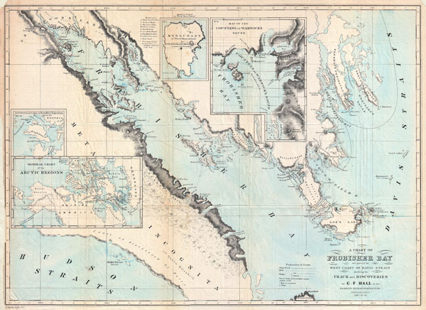
A Chart of Frobisher Bay and part of the West Coast of Davis Strait showing the Track and Discoveries of C. F. Hall on his Franklin Research Expeditions during the years of 1860 - 61 - 62.
sold
- Digital Map Information
- Suitable for large format printing
- File Size: 3.92 MB
- File Type: ZIP / TIFF
- ICC color profile embedded
- Delivered instantly via download link
This is a rare and fascinating 1864 map of Frobisher Bay, Baffin Island and the Davis Straits, Canada prepared to illustrate the explorations and discoveries of Charles Francis Hall. Hall is a fascinating figure in Arctic Exploration. In 1860 Hall, at the time a ... (more details)

Carte de L'Afrique Propre de la Numidie et D'une Partie de la Mauritanie.
$125.00
Acquire
- Digital Map Information
- Suitable for large format printing
- DPI: 300
- File Size: 13.83 MB
- File Type: ZIP / TIFF
- ICC color profile embedded
- Delivered instantly via download link
An unusual and attractive 1843 map of the ancient empires of Mauritania, Carthage, and Numidia shortly after the end of the Second Punic War. Depicts what is today known as the Barbary Coast around 190 BC. The Empire of Carthage has been annexed as a Roman ... (more details)

Carte de L'Afrique Propre de la Numidie et D'une Partie de la Mauritanie.
$125.00
Acquire
- Digital Map Information
- Suitable for large format printing
- DPI: 300
- File Size: 10.32 MB
- File Type: ZIP / TIFF
- ICC color profile embedded
- Delivered instantly via download link
An unusual and attractive 1829 map of the ancient empires of Mauritania, Carthage, and Numidia. Depicts what is today known as the Barbary Coast around 200 BC. This map illustrates a crucial turning point early in the Second Punic War. The Carthaginian ... (more details)
Map revealing the last days of the Barbary Corsairs.

Carte de la Barbarie contenant L'Empire de Maroc et Les Regences D'Alger, De Tunis et de Tripoli.
sold
- Digital Map Information
- Suitable for large format printing
- DPI: 300
- File Size: 12.2 MB
- File Type: ZIP / TIFF
- ICC color profile embedded
- Delivered instantly via download link
A fine first edition example of M. Lapie's 1830 map of the Barbary Coast. This map covers western Mediterranean Coast of Africa from Morocco to Benghazi, including modern day Morocco, Algeria, Tunisia, and Libya. Long a hotbed of piracy and a center for ... (more details)
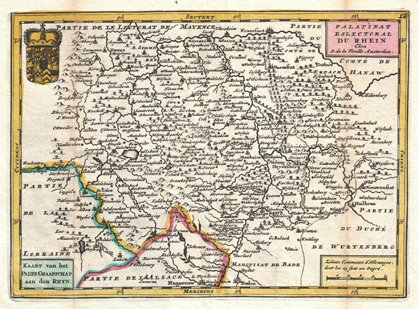
Palatinat Eslectoral du Rhein. Kaart van het Palts Graafschap aan den Rhyn.
sold
- Digital Map Information
- Suitable for large format printing
- DPI: 300
- File Size: 2.67 MB
- File Type: ZIP / TIFF
- ICC color profile embedded
- Delivered instantly via download link
A stunning map of GermanyÂ's Rhineland first drawn by Daniel de la Feuille in 1706. Depicts from Alsace and Lorraine eastward to Württemberg ad northwards as far as Mainz. Names Heidelberg, Manheim, Frankfurt, Mayence, Darmstadt, Manheim and Landaw, ... (more details)
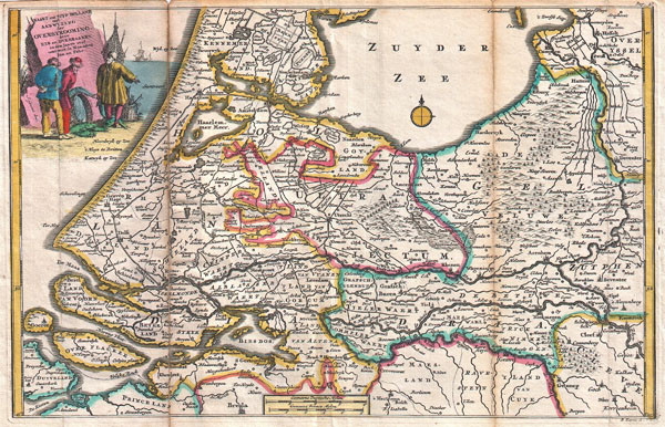
Kaart van Zuyd Holland met Aanwyzing der Overstrooming, door eys en Dykbraaken, in den Jaare 1726 omtrent de Maanden Jan:en Febr.
sold
- Digital Map Information
- Suitable for large format printing
- DPI: 300
- File Size: 4.8 MB
- File Type: ZIP / TIFF
- ICC color profile embedded
- Delivered instantly via download link
A stunning map of Holland first drawn by Daniel de la Feuille in 1706. Depicts Holland south of Amsterdam focusing and the delta and course of the Rhine River. A title cartouche in the upper left quadrant drawn by J. Goeree features three fishermen ... (more details)
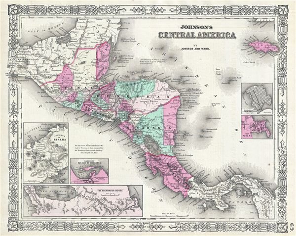
Johnson's Central America.
sold
- Digital Map Information
- Suitable for large format printing
- File Size: 9.75 MB
- File Type: ZIP / TIFF
- ICC color profile embedded
- Delivered instantly via download link
This is A. J. Johnson and Ward's 1864 map of Central America. Covers Central America from the Isthmus of Tehuantepec, Mexico to the Bay of Panama. Shows the countries of Guatemala, Honduras, El Salvador, Nicaragua, and Costa Rica. Jamaica appears ... (more details)

Johnson's Central America.
sold
- Digital Map Information
- Suitable for large format printing
- File Size: 10.46 MB
- File Type: ZIP / TIFF
- ICC color profile embedded
- Delivered instantly via download link
This is A. J. Johnson and Ward's 1862 map of Central America. Covers Central America from the Isthmus of Tehuantepec, Mexico to the Bay of Panama. Shows the countries of Guatemala, Honduras, El Salvador, Nicaragua, and Costa Rica. Jamaica appears ... (more details)

Cuba.
sold
- Digital Map Information
- Suitable for large format printing
- File Size: 8.95 MB
- File Type: ZIP / TIFF
- ICC color profile embedded
- Delivered instantly via download link
A beautiful example of S. A. Mitchell Jr.'s 1872 map of Cuba. Shows cities, towns, railroads and roadways with color coding according to district. Also includes the Great Bahama Bank and many of the Bahama Islands. Shows parts of south Florida, ... (more details)

Sketch G Showing the Progress of the Survey in Section VII from 1849 to 1852.
sold
- Digital Map Information
- Suitable for large format printing
- DPI: 300
- File Size: 5.8 MB
- File Type: ZIP / TIFF
- ICC color profile embedded
- Delivered instantly via download link
An uncommon U.S. Coast Survey map of the Florida Panhandle. Details from Perdido Bay eastwards past Pensacola Bay and Santa Rosa Bay to St. Andrews Bay, St. Georges Sound and Appalachee Bay. Names numerous points, lighthouses, and towns ... (more details)

Sketch C Showing the Progress of the Survey in Section III From 1843 to 1852.
sold
- Digital Map Information
- Suitable for large format printing
- DPI: 300
- File Size: 24.75 MB
- File Type: ZIP / TIFF
- ICC color profile embedded
- Delivered instantly via download link
An uncommon U.S. Coast Survey map and triangulation chart of the Chesapeake Bay. Details from the Hampton Roads in the south north to the mouth of the Susquehanna River, extends westward as far as Washington D.C. and eastwards to include ... (more details)

Sketch K Showing the Progress of the Survey in Section No. XI (upper sheet) from Tillamook Bay to the Boundary from 1850 to 1857.
sold
- Digital Map Information
- Suitable for large format printing
- File Size: 10.16 MB
- File Type: ZIP / TIFF
- ICC color profile embedded
- Delivered instantly via download link
An uncommon U.S. Coast Survey map and triangulation chart of Washington, Vancouver and the Puget Sound. Details from the Columbia River North along the Washington Coast to Cape Flattery and Vancouver Island. Shows the Strait of Juan de ... (more details)

New Map of that portion of North America exhibiting the United States and Territories, the Canadas, New Brunswick, Nova Scotia and Mexico, also, Central America and The West India Islands.
sold
One of the most interesting and attractive 19th century wall maps of North America. Published in 1854 by Jacob Monk, this large and beautiful wall map, details much of North America from the southern border of Canada to Central America, ... (more details)
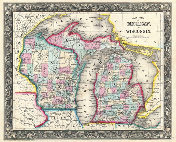
County Map of Michigan and Wisconsin.
sold
- Digital Map Information
- Suitable for large format printing
- File Size: 3.77 MB
- File Type: ZIP / TIFF
- ICC color profile embedded
- Delivered instantly via download link
A beautiful example of the first edition of S. A. Mitchell's 1860 map of Michigan and Wisconsin. Depicts both states in considerable detail with color coding at the county level. Also includes all of Lake Michigan and Lake Huron as ... (more details)

Celebes.
sold
- Digital Map Information
- Suitable for large format printing
- File Size: 28.35 MB
- File Type: ZIP / TIFF
- ICC color profile embedded
- Delivered instantly via download link
A stunning large format Japanese map of Celebes dating to World War II. Covers the entirety of the island and its vicinity with color coding according to area Offers superb detail regarding both topographical and political ... (more details)
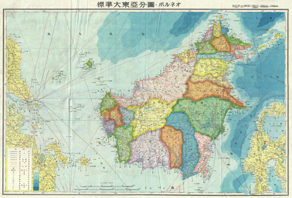
Borneo
sold
- Digital Map Information
- Suitable for large format printing
- File Size: 26.22 MB
- File Type: ZIP / TIFF
- ICC color profile embedded
- Delivered instantly via download link
A stunning large format Japanese map of Borneo dating to World War II. Covers the entirety of the island with color coding according to district. Offers superb detail regarding both topographical and political elements. ... (more details)
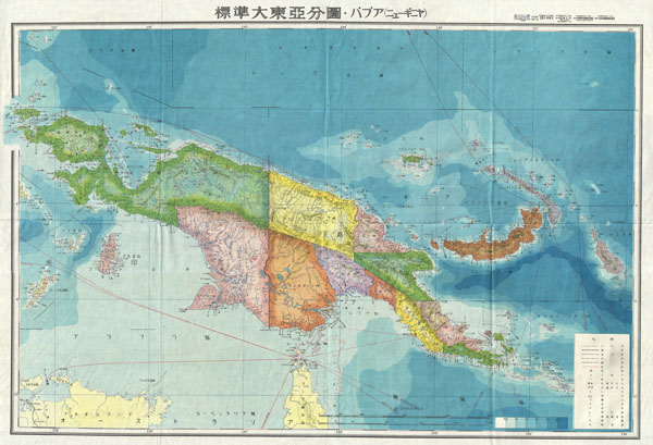
New Guinea.
sold
- Digital Map Information
- Suitable for large format printing
- File Size: 27.62 MB
- File Type: ZIP / TIFF
- ICC color profile embedded
- Delivered instantly via download link
A stunning large format Japanese map of New Guinea dating to World War II. Covers the entirety of the island with color coding according to district. Offers superb detail regarding both topographical and political ... (more details)