
Lovely map of the Republic of the United Provinces.

Les Pays Bas Francois, Autrichiens, et Hollandois.
sold
- Digital Map Information
- Suitable for large format printing
- DPI: 300
- File Size: 14.69 MB
- File Type: ZIP / TIFF
- ICC color profile embedded
- Delivered instantly via download link
This is beautiful map of Holland (The Netherlands) and Luxemburg by the French Cartographer Louis Brion de la Tour. It extends from the North Sea south to include Luxembourg. Covers Netherlands and Luxemburg. The 'Republic of the United Provinces' was officially ... (more details)
Notes the Tribes of Israel.

Palestine and Adjacent Countries.
sold
- Digital Map Information
- Suitable for large format printing
- DPI: 300
- File Size: 7.57 MB
- File Type: ZIP / TIFF
- ICC color profile embedded
- Delivered instantly via download link
This is a fine example of S. A. Mitchell's 1849 map of Palestine, Israel, or the Holy Land. This map is a curious combination of a contemporary and a historic map. The color coding details the region as it may have appeared in Biblical times, with the lands ... (more details)
Notes the legendary Mountains of the Moon.

Africa.
sold
- Digital Map Information
- Suitable for large format printing
- DPI: 300
- File Size: 7.36 MB
- File Type: ZIP / TIFF
- ICC color profile embedded
- Delivered instantly via download link
This is a fine example of S. A. Mitchell's 1849 map of Africa and Liberia. Details the continent of Africa on the cusp of the great exploratory expeditions of the mid-19th century undertaken by Speke, Livingstone, and Stanley. Much of the interior remains ... (more details)
Includes Korea and Taiwan.

China.
sold
- Digital Map Information
- Suitable for large format printing
- DPI: 300
- File Size: 7.03 MB
- File Type: ZIP / TIFF
- ICC color profile embedded
- Delivered instantly via download link
A fine example of S. A. Mitchell's 1849 map of China. Covers the traditional provinces of mainland China as well as parts of adjacent Chinese Tartary, Tonkin (Vietnam), Formosa (Taiwan), and Korea (Corea). Hong Kong is identified as a British Territory. ... (more details)
The Indian subcontinent under British Rule.

Hindoostan.
sold
- Digital Map Information
- Suitable for large format printing
- DPI: 300
- File Size: 8.01 MB
- File Type: ZIP / TIFF
- ICC color profile embedded
- Delivered instantly via download link
This is an attractive example of S. A. Mitchell's 1849 map of India. It covers the Indian subcontinent in considerable detail, with princely states and British possessions color coded. An inset in the lower right hand quadrant details the Delta of the ... (more details)
Beautiful mid-19th century map of the Middle East.

Persia Arabia etc.
sold
- Digital Map Information
- Suitable for large format printing
- DPI: 300
- File Size: 6.92 MB
- File Type: ZIP / TIFF
- ICC color profile embedded
- Delivered instantly via download link
This is a beautiful hand colored map of Persian and Arabia, dating to 1850, by the legendary American map publisher S.A. Mitchell, the elder. Includes what is today Saudi Arabia, Israel, Syria, Jordan, Iran, Iraq and Afghanistan. Mitchell offers a ... (more details)
Inculdes an inset of Australia.

Asia.
sold
- Digital Map Information
- Suitable for large format printing
- DPI: 300
- File Size: 8.62 MB
- File Type: ZIP / TIFF
- ICC color profile embedded
- Delivered instantly via download link
This is a beautiful example of the legendary American map publisher Samuel Augustus Mitchell's 1849 map of Asia. This map covers from the Arabian Peninsula and Turkey eastward as far as Kamchatka, Japan, the Philippines and New Guinea. It includes ... (more details)
Mitchell's depiction of the southern portions of modern Greece.

Greece.
sold
- Digital Map Information
- Suitable for large format printing
- DPI: 300
- File Size: 8.83 MB
- File Type: ZIP / TIFF
- ICC color profile embedded
- Delivered instantly via download link
A fine example of S. A. Mitchell's 1849 map of Greece. Extends from Ioannina and Triekhala south to include the Euboea (Negropont) and the Peloponnese (Morea). Covers the southern part of modern Greece including the Peloponnese (Morea), the ... (more details)
European Turkey during the Ottoman rule.

Turkey in Europe.
sold
- Digital Map Information
- Suitable for large format printing
- DPI: 300
- File Size: 5.16 MB
- File Type: ZIP / TIFF
- ICC color profile embedded
- Delivered instantly via download link
This is a lovely 1849 map of European Turkey by S. A. Mitchell. This map, made when the Ottoman Empire controlled much of the region, covers what is today Turkey, Greece, Macedonia Croatia, Bosnia, Serbia, Romania, Bulgaria, Macedonia and ... (more details)
Rare Persian langauge variant of the Fred Rose 'Octopus Map' of Euopre. One of only 2 known examples.
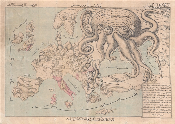
Comic Map of Europe. / نقشه طنز از اروپا
sold
- Digital Map Information
- Suitable for large format printing
- File Size: 10.45 MB
- File Type: ZIP / TIFF
- ICC color profile embedded
- Delivered instantly via download link
A very rare c. 1880 Persian version of Englishman Fred Rose's iconic 1877 Serio Comic War Map , in which expansionist Imperial Russia is analogized as a menacing grasping octopus. Iranians at this time were beset by incursions from both ... (more details)
Battle of Shanghai field commander's map with manuscript annotations describing the fighting.

[Greater Shanghai]
sold
- Digital Map Information
- Suitable for large format printing
- File Size: 55.03 MB
- File Type: ZIP / TIFF
- ICC color profile embedded
- Delivered instantly via download link
An enormous map of great historical importance, this is a large format c. 1937 Japanese field commander's map of the greater Shanghai area with original manuscript annotations relating to troop losses, movement, and strategy during the ... (more details)
Early map showing the mouth of the Mississippi River.
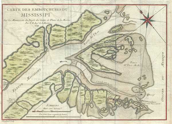
Carte des Embouchures du Mississipi.
sold
- Digital Map Information
- Suitable for large format printing
- DPI: 300
- File Size: 3.56 MB
- File Type: ZIP / TIFF
- ICC color profile embedded
- Delivered instantly via download link
This is a scarce 1744 map by Bellin depicting the mouth of the Mississippi River as it empties into the Gulf of Mexico. The map identifies Fort Balize, the first French fort and settlement in the region. Bellin also notes important ... (more details)
One of the earliest obtainable plan of the Harbor of Pensacola, Florida.
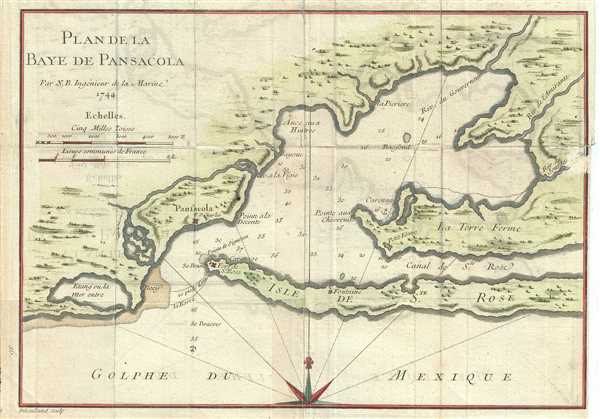
Plan de la Baye de Pensacola.
sold
- Digital Map Information
- Suitable for large format printing
- DPI: 300
- File Size: 2.65 MB
- File Type: ZIP / TIFF
- ICC color profile embedded
- Delivered instantly via download link
This is a beautiful early 1744 map or chart of Pensacola Harbor in Florida by Bellin. Among the earliest available charts of the bay and harbor, the map identifies the locations of Fort St. Charles and fort St. Rose. Bellin also ... (more details)
Among the earliest obtainable specific maps of the Louisiana, Mississippi, Florida coasts.
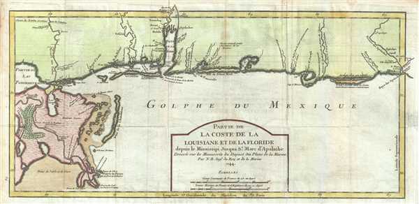
Partie de La Coste de la Louisiane et de La Floride depuis le Mississipi Jusqua St. Marc d'Apalache. Dressee sur les Manuscrits du Depost des Plans de la Marine.
sold
- Digital Map Information
- Suitable for large format printing
- DPI: 300
- File Size: 4.5 MB
- File Type: ZIP / TIFF
- ICC color profile embedded
- Delivered instantly via download link
The extremely scarce first edition first state of Bellin's important 1744 map of the Gulf Coast from New Orleans past Mobile Bay, as far east as Apalachicola Bay and the St. Marks River. Though still quite speculative, ... (more details)
The earliest obtainable map or plan of New Orleans, Louisiana.
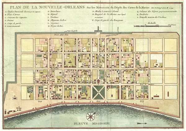
Plan de la Nouvelle-Orleans sur les Manuscrits du Depot des Cartes de la Marine.
sold
- Digital Map Information
- Suitable for large format printing
- DPI: 300
- File Size: 2.81 MB
- File Type: ZIP / TIFF
- ICC color profile embedded
- Delivered instantly via download link
This scarce 1744 map by J. N. Bellin is the first edition first state of earliest obtainable map of New Orleans, Louisiana. Oriented to the northwest, Bellin's map covers the original settlement of New Orleans along the ... (more details)
Southern Italy during the struggle for unification.

Kingdom of Naples or The Two Sicilies.
sold
- Digital Map Information
- Suitable for large format printing
- DPI: 300
- File Size: 6.63 MB
- File Type: ZIP / TIFF
- ICC color profile embedded
- Delivered instantly via download link
This is a lovely 1849 map of the Kingdom of Naples of the Two Sicilies by S. A. Mitchell. Covers the southern parts of modern Italy from Rome to Sicily. An inset detailing the environs of Naples is included in the lower ... (more details)
Mid 19th century map of Tuscany, Milan and Venice.

Italy. North Part.
sold
- Digital Map Information
- Suitable for large format printing
- DPI: 300
- File Size: 5.55 MB
- File Type: ZIP / TIFF
- ICC color profile embedded
- Delivered instantly via download link
This is a fine example of S. A. Mitchell's 1849 map of the north part of Italy. Centered on Tuscany, this map covers from Lombardy to the Papal States (Including Rome), and the Venetian Republic. Political and ... (more details)
Map of the Austrian Empire.

Austrian Empire.
sold
- Digital Map Information
- Suitable for large format printing
- DPI: 300
- File Size: 7.55 MB
- File Type: ZIP / TIFF
- ICC color profile embedded
- Delivered instantly via download link
This is a lovely map of the Austrian Empire by Samuel Augustus Mitchell dating to 1849. Covers the territories claimed by the once vast Austro-Hungarian Empire, including in whole or part the modern day ... (more details)
The Kingdom of Sardinia on the brink of the Crimean War.

Kingdom of Sardinia.
sold
- Digital Map Information
- Suitable for large format printing
- DPI: 300
- File Size: 7.83 MB
- File Type: ZIP / TIFF
- ICC color profile embedded
- Delivered instantly via download link
This is a beautiful example of the S. A. Mitchell's 1849 map of Kingdom of Sardinia. Centered in Piedmont, this map covers the Kingdom of Sardinia's claims both on the Island of Sardinia and the ... (more details)
Denmark including the Duchy of Holstein.

Denmark.
sold
- Digital Map Information
- Suitable for large format printing
- DPI: 300
- File Size: 5.15 MB
- File Type: ZIP / TIFF
- ICC color profile embedded
- Delivered instantly via download link
This is a nice 1849 map of Denmark by Samuel Augustus Mitchell. Covers all of Denmark inclusive of the Duchy of Holstein. A list along the upper left border notes Denmark's five Provinces: ... (more details)