

Plan du Port de Mozambique et du Pays Adjacent.
sold
- Digital Map Information
- Suitable for large format printing
- Full resolution TIFF file
- ICC color profile embedded
- Delivered instantly via download link
A scarce and important 1809 Henry Salt nautical chart or maritime map of the port and island of Mozambique, Nampula Province, Mozambique, Africa. The map covers the Harbor of Mazambique, the city of Mossuril, and the Island of Mozambique, as well as some of the ... (more details)
Rare first edition Burritt charts with individually colorized constellations.

January February March. April May June. July August September. October November December.
sold
- Digital Map Information
- Suitable for large format printing
- Full resolution TIFF file
- ICC color profile embedded
- Delivered instantly via download link
This is a beautifully hand colored set of four maps depicting the night sky in the twelve months of the year, by Elijah Burritt. Each sheet features the stars and constellation in the night sky over a quarter. On each of the charts, the constellations are drawn ... (more details)

A Celestial Planisphere, or Map of the Heavens.
sold
- Digital Map Information
- Suitable for large format printing
- File Size: 16.52 MB
- File Type: ZIP / TIFF
- ICC color profile embedded
- Delivered instantly via download link
This is a rare and beautifully hand colored map of the night sky by Elijah Burritt. Centered on the ecliptic Line, this map identifying the various zones associated with each major constellation. The Milky Way is shaded in. A scale exhibiting the sun's place ... (more details)
Rare first edition Burritt charts with individually colorized constellations.

Northern Circumpolar Map for each Month in the Year. Southern Circumpolar Map for each Month in the Year.
sold
- Digital Map Information
- Suitable for large format printing
- Full resolution TIFF file
- ICC color profile embedded
- Delivered instantly via download link
This is a beautiful hand colored set of the northern and southern circumpolar maps by Elijah Burritt. This pair of maps illustrates the night sky and constellations of both the northern hemisphere and southern hemisphere respectively. Constellations are drawn ... (more details)
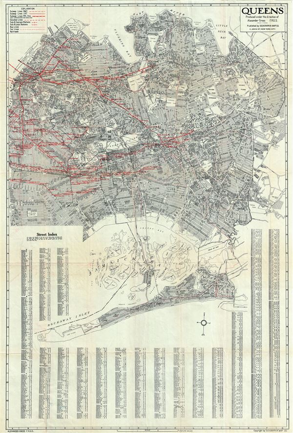
Queens.
sold
- Digital Map Information
- Suitable for large format printing
- File Size: 35.29 MB
- File Type: ZIP / TIFF
- ICC color profile embedded
- Delivered instantly via download link
This is an impressive 1930s map of or plan of Queens, New York, issued by Alexander Gross and published by the Geographia Map Company. The map covers the easternmost of the five boroughs of New York City from Rockaway Point (Breezy Point) northward to the East ... (more details)

Malay Peninsula and Sumatra.
sold
- Digital Map Information
- Suitable for large format printing
- File Size: 15.02 MB
- File Type: ZIP / TIFF
- ICC color profile embedded
- Delivered instantly via download link
This is a large and beautiful 1942 World War II era map of the Malay Peninsula (Malaysia) and Sumatra, Indonesia, issued by the Survey Bureau of Manchuria State. The map covers the Malay Peninsula, including Singapore, as well as the island of Sumatra, ... (more details)
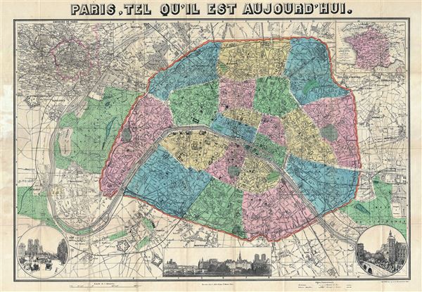
Paris, Tel Qu'Il est Aujourd'hui.
sold
- Digital Map Information
- Suitable for large format printing
- File Size: 37.68 MB
- File Type: ZIP / TIFF
- ICC color profile embedded
- Delivered instantly via download link
This is an extremely attractive tourist map or plan of Paris, France from about 1900, issued by L Joly. Centered on the Seine River, it covers embastilled Paris as contained in the Thiers Wall as well as its immediate vicinity, including the Bois de ... (more details)
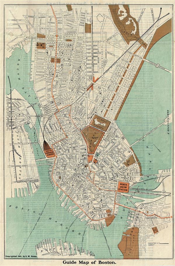
Guide Map of Boston.
sold
- Digital Map Information
- Suitable for large format printing
- File Size: 10.09 MB
- File Type: ZIP / TIFF
- ICC color profile embedded
- Delivered instantly via download link
This is an attractive 1901 tourist map or plan of the city of Boston, Massachusetts by C. W. Hobbs. Oriented to the southeast, it covers the city from Boston Harbor to Back Bay Park and includes parts of South Boston, East Boston and Charlestown. ... (more details)
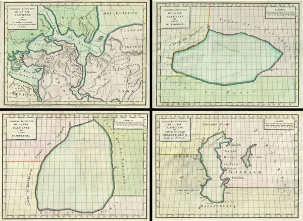
Premiere revolution de la mer Caspienne ou Carte qui indique son Etendue vers le tems de la Population Primitive de l'Asie. Seconde Revolution de la mer Caspienne ou carte de Ptolemee. Troissieme Revolution de la mer Caspienne ou carte d'Abulfeda. Quatrieme Revolution de la mer Caspienne ou carte du Czar Pierre le Grand Rectifiee par Mr. d'Anville.
sold
- Digital Map Information
- Suitable for large format printing
- DPI: 300
- File Size: 17.35 MB
- File Type: ZIP / TIFF
- ICC color profile embedded
- Delivered instantly via download link
This is a fascinating 1792 set of four maps of the Caspian Sea by Jean-Baptiste-Claude Delisle de Sales. They illustrate the mapping of the Caspian Sea over time. The first map, from upper left, represents a theoretical early period, in which ... (more details)

A Plan of the Solar System exhibiting its relative Magnitudes and Distances.
sold
- Digital Map Information
- Suitable for large format printing
- File Size: 19.01 MB
- File Type: ZIP / TIFF
- ICC color profile embedded
- Delivered instantly via download link
This rare 1856 map or chart by Elijah Burritt illustrates the plan of the Solar System and the relative magnitude and distances of the primary planets. It shows the primary planets in relation to one another both with regard to magnitude and ... (more details)

The Constellations for each Month in the Year.
sold
- Digital Map Information
- Suitable for large format printing
- File Size: 17.87 MB
- File Type: ZIP / TIFF
- ICC color profile embedded
- Delivered instantly via download link
This rare hand colored map set depicting the stars of the northern and southern hemispheres was engraved W. G. Evans of New York for Burritt's 1856 edition of the Atlas to Illustrate the Geography of the Heavens. The pair of maps ... (more details)

March February January.
sold
- Digital Map Information
- Suitable for large format printing
- File Size: 8.86 MB
- File Type: ZIP / TIFF
- ICC color profile embedded
- Delivered instantly via download link
This rare hand colored map of the stars was engraved W. G. Evans of New York for Burritt's 1835 edition of the Atlas to Illustrate the Geography of the Heavens. It represents the Northern night sky in the months of January, ... (more details)
Scarce map of Canada and the Great Lakes on the Eve of the French and Indian War.

Carta Geografica Del Canada Nell' America Settentrionale.
sold
- Digital Map Information
- Suitable for large format printing
- DPI: 300
- File Size: 9.31 MB
- File Type: ZIP / TIFF
- ICC color profile embedded
- Delivered instantly via download link
An attractive 1740 map of Canada and the Great lakes by Giambattista Albrizzi. This map offers an exceptional overview of French America on the eve of the French and Indian War. Based upon a 1708 revision of a 1703 map by ... (more details)
An uncommon decorative map of North America.
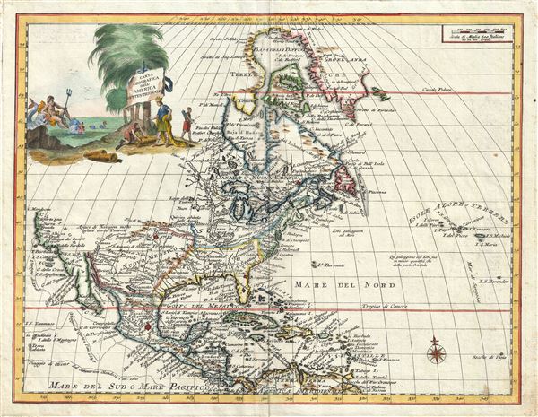
Carta Geografica Dell' America Settentrionale.
sold
- Digital Map Information
- Suitable for large format printing
- DPI: 300
- File Size: 9.32 MB
- File Type: ZIP / TIFF
- ICC color profile embedded
- Delivered instantly via download link
An attractive 1740 map of North American by Giambattista Albrizzi. Based upon an earlier map by Guillaume Delisle, this map covers all of North America from Baffin Bay to Panama and the Spanish Main and from the Atlantic ... (more details)
A rare decorative map of the southeastern United States in the colonial period.

Carta Geografica Della Florida Nell' America Settentrionale.
sold
- Digital Map Information
- Suitable for large format printing
- DPI: 300
- File Size: 9.27 MB
- File Type: ZIP / TIFF
- ICC color profile embedded
- Delivered instantly via download link
This scarce map by Giambattista Albrizzi is a curious and somewhat retrogressive 1740 Italian variant on Delisle's 1718 map of Texas, Louisiana, Florida, and the southeastern British coastal colonies. Roughly following ... (more details)
Scarce and important 18th century Italian map of the world.

Mappamondo, o sia Descrizione Generale del Globo Terrestre ed Acuatico.
sold
- Digital Map Information
- Suitable for large format printing
- DPI: 300
- File Size: 8.35 MB
- File Type: ZIP / TIFF
- ICC color profile embedded
- Delivered instantly via download link
A striking 1750 double hemisphere map of the world by the Italian map publisher Giambattista Albrizzi. This is one of the most interesting and decorative world maps to appear in a mid-18th century atlas. Like most ... (more details)
Scarce map of the Pesian Gulf.

Carte du Golfe de Perse.
sold
- Digital Map Information
- Suitable for large format printing
- DPI: 300
- File Size: 4.25 MB
- File Type: ZIP / TIFF
- ICC color profile embedded
- Delivered instantly via download link
This is a beautiful example of the 1770 Jean-Baptiste-Claude Delisle de Sales' map of the Persian Gulf. The map covers from Basra to the Strait of Hormuz, and includes parts of modern day Kuwait, Bahrain, Qatar, ... (more details)
One of a kind manuscript map illustrating Tongyeong, an important South Korean city and former naval fort.

[Tongyeong]
sold
- Digital Map Information
- Suitable for large format printing
- DPI: 300
- File Size: 40.7 MB
- File Type: ZIP / TIFF
- ICC color profile embedded
- Delivered instantly via download link
A scarce early 19th century Korean map of the famous naval base at Tongyeong. The map covers the old naval base, at center, as well as many of the surrounding islands and seas. As with many East Asian maps of ... (more details)
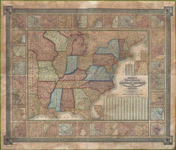
Mitchell’s National Map of the American Republic or The United States of North America. Together with Maps of the Vicinities of Thirty-Two Principal Cities and Towns in the Union.
sold
- Digital Map Information
- Suitable for large format printing
- DPI: 300
- File Size: 96.99 MB
- File Type: ZIP / TIFF
- ICC color profile embedded
- Delivered instantly via download link
This is a stunning 1843 wall map of the United States of America by the S.A. Mitchell firm. The S. A Mitchell firm published this map, both in wall and folding pocket format, from 1843 to 1850. It is ... (more details)

Central Park Guide.
sold
- Digital Map Information
- Suitable for large format printing
- File Size: 2.63 MB
- File Type: ZIP / TIFF
- ICC color profile embedded
- Delivered instantly via download link
An altogether extraordinary 1862 hand colored map of New York City's Central Park prepared and printed for inclusion in the Fifth Annual Report of the Board of Commissioners of the Central Park. It ... (more details)