

12th Day.
sold
- Digital Map Information
- Suitable for large format printing
- File Size: 2.48 MB
- File Type: ZIP / TIFF
- ICC color profile embedded
- Delivered instantly via download link
This is a fascinating example of Philip's 1892 map or Chart of the Moon on its 12th day. This chart was created to study the various lunar formations during its various stages – from new to full. This particular chart represents the Moon on its 12th day. The ... (more details)

11th Day.
sold
- Digital Map Information
- Suitable for large format printing
- File Size: 2.25 MB
- File Type: ZIP / TIFF
- ICC color profile embedded
- Delivered instantly via download link
This is a fascinating example of Philip's 1892 map or Chart of the Moon on its 11th day. This chart was created to study the various lunar formations during its various stages – from new to full. This particular chart represents the Moon on its 11th day. The ... (more details)

Jupiter & Comets.
sold
- Digital Map Information
- Suitable for large format printing
- File Size: 1.22 MB
- File Type: ZIP / TIFF
- ICC color profile embedded
- Delivered instantly via download link
This is a fine example of Philip's 1892 map or chart of Jupiter and comets. Divided into two sections, the right section of the map features two diagrams depicting 'The tail of the comet directed from the Sun' and Bredichin's theory of comets' tails.' The left ... (more details)

Village of Buffalo.
sold
- Digital Map Information
- Suitable for large format printing
- DPI: 300
- File Size: 9 MB
- File Type: ZIP / TIFF
- ICC color profile embedded
- Delivered instantly via download link
This is a fascinating example of the 1804 Joseph Ellicott map of the village of Buffalo, New York. Covers eastward from Lake Erie, focusing on the downtown area of Buffalo. Upper left quadrant contains an inset of the Map of the Village of New Amsterdam - as ... (more details)
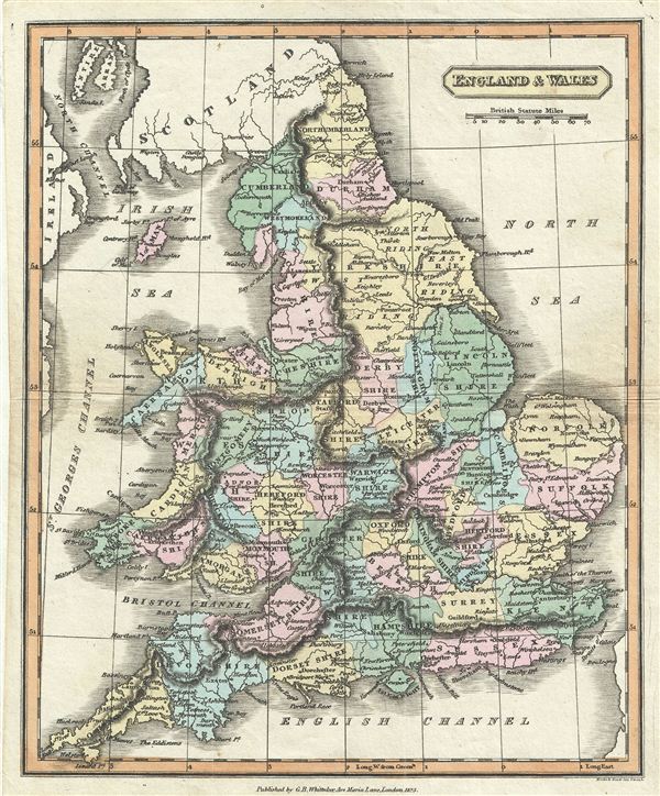
England & Wales.
sold
- Digital Map Information
- Suitable for large format printing
- Full resolution TIFF file
- ICC color profile embedded
- Delivered instantly via download link
This is a fine example of G. B. Whittaker's 1825 map of england and Wales. The map covers both england and Wales from Northumberland to Cornwall and includes the Isle of Man. At this time in history, the Kingdom of Great Britain and the Kingdom of Ireland ... (more details)
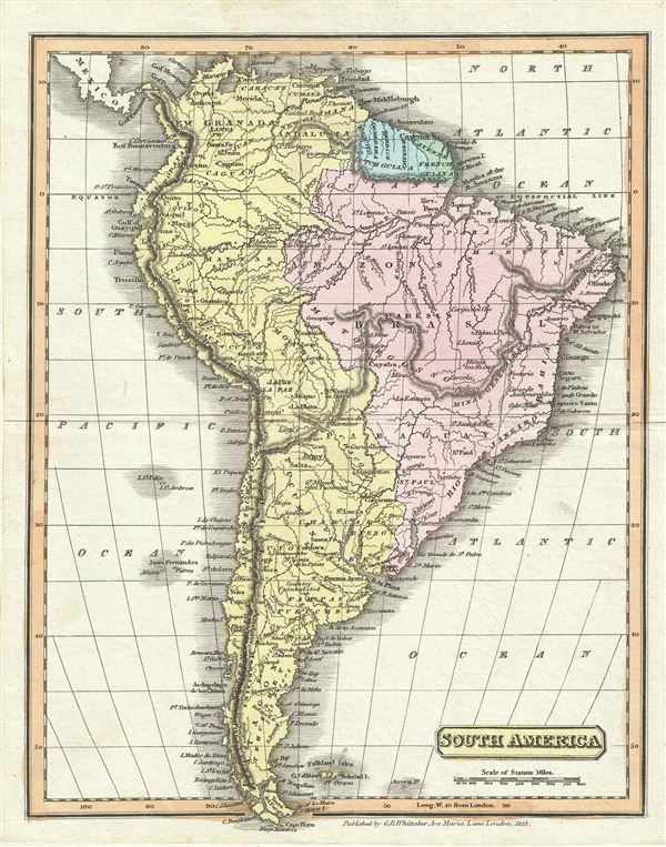
South America.
sold
- Digital Map Information
- Suitable for large format printing
- DPI: 300
- File Size: 3.3 MB
- File Type: ZIP / TIFF
- ICC color profile embedded
- Delivered instantly via download link
This is a fine example of Whittaker' 1825 map of South America. It covers all of South America from the Pacific Ocean to the Atlantic Ocean including the Falkland Islands. During this time in history most of the continent was struggling for independence. ... (more details)

South America.
sold
- Digital Map Information
- Suitable for large format printing
- DPI: 300
- File Size: 3.4 MB
- File Type: ZIP / TIFF
- ICC color profile embedded
- Delivered instantly via download link
This is a fine example of Samuel Butler's 1822 map of South America. It covers all of South America from the Pacific Ocean to the Atlantic Ocean including the Falkland and Georgia Islands. During this time in history most of the continent was in the midst ... (more details)

Turkey in Europe & Hungary.
sold
- Digital Map Information
- Suitable for large format printing
- DPI: 300
- File Size: 3.88 MB
- File Type: ZIP / TIFF
- ICC color profile embedded
- Delivered instantly via download link
This is a fine example of Samuel Butler's 1822 map of Greece, the Balkans, Hungary and the european part of Turkey. The map covers Turkey and Greece from the Gulf of Venice and the Ionian Sea to the Black Sea. It shows Hungary, Moldova, Wallachia, ... (more details)
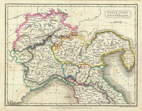
North Italy and Switzerland.
sold
- Digital Map Information
- Suitable for large format printing
- DPI: 300
- File Size: 3.21 MB
- File Type: ZIP / TIFF
- ICC color profile embedded
- Delivered instantly via download link
This is a fine example of Samuel Butler's 1822 map of North Italy and Switzerland. It covers the northern part of Italy depicting the territories of Tuscany, Modena, Parma, Kingdom of Sardinia, Lombardy, and parts of the State of the Church. ... (more details)
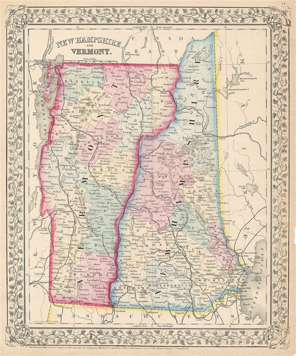
New Hampshire and Vermont.
sold
- Digital Map Information
- Suitable for large format printing
- File Size: 6.25 MB
- File Type: ZIP / TIFF
- ICC color profile embedded
- Delivered instantly via download link
A beautiful example of the American map publisher Samuel Augustus Mitchell Jr.'s 1867 map of New Hampshire and Vermont. Centered on the Connecticut River, which forms the border between New Hampshire and Vermont, this map covers both states ... (more details)
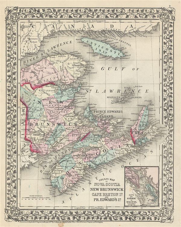
County Map of Nova Scotia, New Brunswick, Cape Breton Is. And Pr. Edward's Id.
sold
- Digital Map Information
- Suitable for large format printing
- File Size: 7.6 MB
- File Type: ZIP / TIFF
- ICC color profile embedded
- Delivered instantly via download link
A beautiful example of S. A. Mitchell's 1877 map of the Canadian Maritime Provinces of Nova Scotia, New Brunswick, Prince edward's Island, and Cape Breton Island. Detailed to the county level with special attention both political and ... (more details)
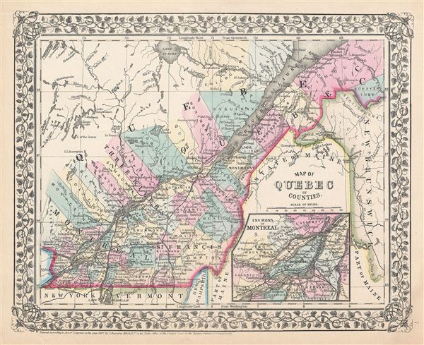
Map of Quebec in counties.
sold
- Digital Map Information
- Suitable for large format printing
- File Size: 6.16 MB
- File Type: ZIP / TIFF
- ICC color profile embedded
- Delivered instantly via download link
A beautiful example of the legendary American map publisher Samuel Augustus Mitchell Jr.'s 1867 map of the Canadian province of Quebec, or Canada east. Centered on the St. Lawrence River Valley, this map covers from Montreal to the ... (more details)

Map of Ontario in Counties.
sold
- Digital Map Information
- Suitable for large format printing
- File Size: 7.1 MB
- File Type: ZIP / TIFF
- ICC color profile embedded
- Delivered instantly via download link
A beautiful example of S. A. Mitchell Jr.'s 1867 map of Ontario. Detailed to the county level with special attention both political and geographic elements. The map notes important river systems, railways, canals, and cities. One ... (more details)
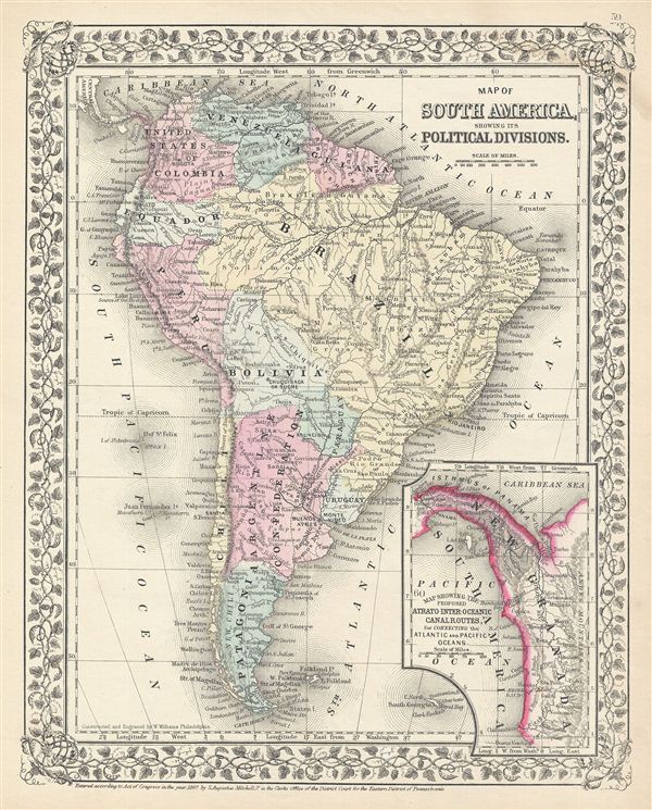
Map of South America, showing its Political Divisions.
sold
- Digital Map Information
- Suitable for large format printing
- File Size: 7.2 MB
- File Type: ZIP / TIFF
- ICC color profile embedded
- Delivered instantly via download link
A beautiful example of the legendary American map publisher Samuel Augustus Mitchell Jr.'s 1867 map of South America. Depicting the whole continent from Panama to Cape Horn, it includes the Falkland and South Georgia island groups. ... (more details)
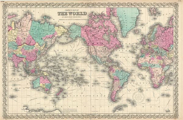
Colton's Map of The World on Mercator's Projection.
sold
- Digital Map Information
- Suitable for large format printing
- File Size: 19.09 MB
- File Type: ZIP / TIFF
- ICC color profile embedded
- Delivered instantly via download link
An excellent 1855 first edition example of Colton's map of the World on a Mercator's Projection. This map is a reduction and re-engraving of Colton's important 1848 wall map of the world. Colton offers a fascinating snapshot of ... (more details)

New York.
sold
- Digital Map Information
- Suitable for large format printing
- File Size: 10.3 MB
- File Type: ZIP / TIFF
- ICC color profile embedded
- Delivered instantly via download link
A beautiful 1855 first edition example of Colton's map of New York. Like most of Colton's state maps, this map was derived from an earlier wall map of North America produced by Colton and D. Griffing Johnson. Covers the entire ... (more details)

Canada West or Upper Canada.
sold
- Digital Map Information
- Suitable for large format printing
- File Size: 9.69 MB
- File Type: ZIP / TIFF
- ICC color profile embedded
- Delivered instantly via download link
An excellent first edition example of Colton's rare 1855 map of Ontario. Covers what at the time was called Upper or West Canada from Michigan to Montreal. Includes Lake erie, Lake Ontario, and part of Lake Huron. Two insets ... (more details)

North America.
sold
- Digital Map Information
- Suitable for large format printing
- File Size: 10.04 MB
- File Type: ZIP / TIFF
- ICC color profile embedded
- Delivered instantly via download link
An excellent 1855 first edition example of Colton's desirable map of North America. The map covers the continent from South America to the Arctic, inclusive of the United States, Canada, Mexico, Central America and the West ... (more details)
Magnificent 18th century wall map of Europe.
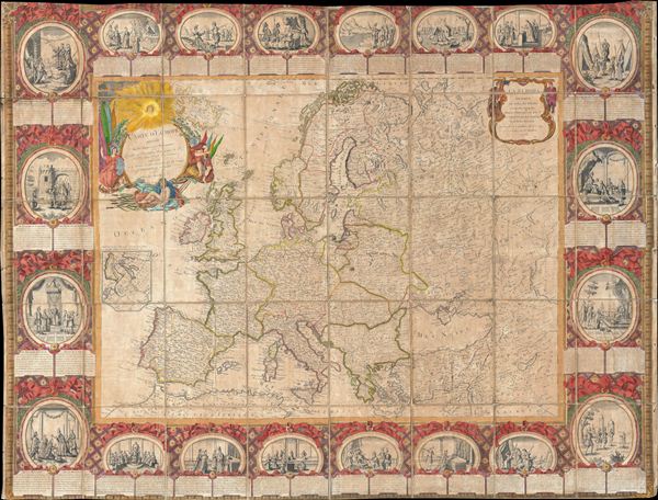
Carte D'Eurpe Divisee En ses Empires et Royaumes.
sold
- Digital Map Information
- Suitable for large format printing
- DPI: 300
- File Size: 77.43 MB
- File Type: ZIP / TIFF
- ICC color profile embedded
- Delivered instantly via download link
A large and impressively decorative 1776 case map or pocket map of europe by Jean Baptiste Louis Clouet. Clouet's map covers all of europe from Spain to the Ural Mountains and from Nova Zembla and the Arctic Ocean to North ... (more details)
One of the earliest obtainable maps of New England. Shows Norumbega, the 'New England El Dorado'.
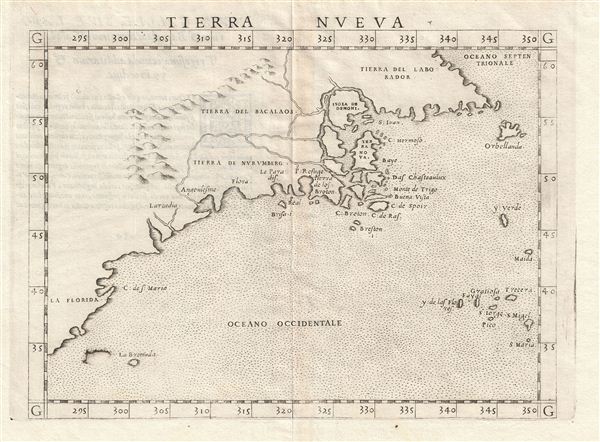
Tierra Nveva.
sold
- Digital Map Information
- Suitable for large format printing
- DPI: 300
- File Size: 3.1 MB
- File Type: ZIP / TIFF
- ICC color profile embedded
- Delivered instantly via download link
This is the first state, first edition, of Girolamo Ruscelli's 1561 map 'Tierra Nveva,' an early and influential map of what would become New england and the Canadian Maritime Provinces. The map covers the eastern coastline ... (more details)