
Stunning general map of the Yosemite National Park.
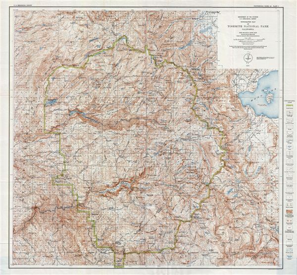
Topographic Map of Yosemite National Park California.
sold
- Digital Map Information
- Suitable for large format printing
- File Size: 44.83 MB
- File Type: ZIP / TIFF
- ICC color profile embedded
- Delivered instantly via download link
A fine example of Francois e. Matthes' 1930 topographical survey map of the spectacular Yosemite National Park, California. The map covers the entire park along with surrounding areas from Stanislaus National Forest to Mono Lake and the Mono National Forest. The ... (more details)
Historic Map of one of the world' most beautiful destinations.
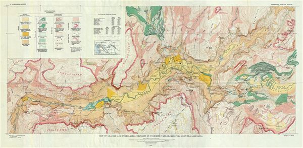
Map of Glacial and Postglacial Deposits in Yosemite Valley, Mariposa County, California.
sold
- Digital Map Information
- Suitable for large format printing
- File Size: 27.38 MB
- File Type: ZIP / TIFF
- ICC color profile embedded
- Delivered instantly via download link
A fine example of Francois e. Matthes' 1930 map of the glacial and postglacial deposits in the spectacular Yosemite Valley in Yosemite National Park, California. Centered on the Merced River, this map covers the region along the Yosemite from elephant Rock as far ... (more details)
Historic map of one of the world' most beautiful destinations.
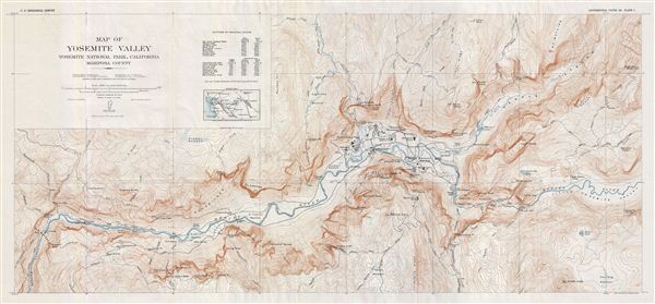
Map of Yosemite Valley Yosemite National Park, California Mariposa County.
sold
- Digital Map Information
- Suitable for large format printing
- File Size: 24.94 MB
- File Type: ZIP / TIFF
- ICC color profile embedded
- Delivered instantly via download link
A fine example of Francois e. Matthes' 1930 map of the spectacular Yosemite Valley in Yosemite National Park, California. Centered on the Merced River, this map covers the Yosemite Valley along the from elephant Rock as far east as Clouds Rest. The altitude of ... (more details)
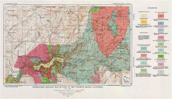
Generalized Geologic Map of Part of the Yosemite Region, California.
sold
- Digital Map Information
- Suitable for large format printing
- File Size: 8.59 MB
- File Type: ZIP / TIFF
- ICC color profile embedded
- Delivered instantly via download link
A fine example of Francois e. Matthes' 1930 generalized geologic map of the spectacular Yosemite National Park region, California. The map covers the region from the Ten Lakes to Peregoy Meadow in and from the Aspen Valley to Mt. Florence. Throughout ... (more details)
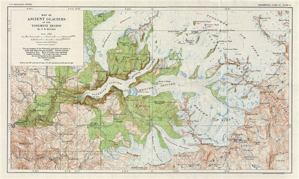
Map of Ancient Glaciers of the Yosemite Region By F. E. Matthes.
sold
- Digital Map Information
- Suitable for large format printing
- File Size: 8.52 MB
- File Type: ZIP / TIFF
- ICC color profile embedded
- Delivered instantly via download link
A fine example of Francois e. Matthes' 1930 geological survey map of the spectacular Ancient Glaciers of the Yosemite Valley, California. Centered on Liberty Cap, the map depicts the ice streams of the Wisconsin glaciation and covers from Mammoth peak ... (more details)
The only known example of an unrecorded 1838 American issue of A. Arrowsmith's Globular Map of the World. Shows Republic of Texas.
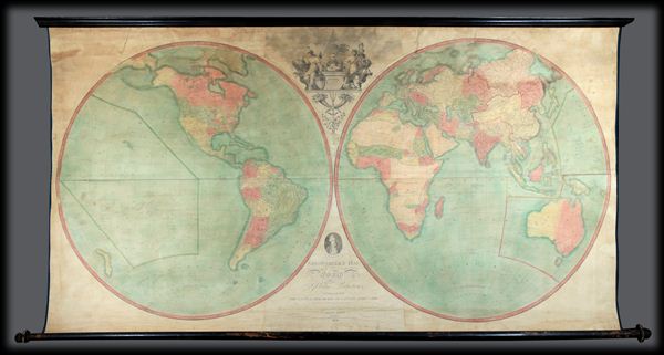
Arrowsmith's Map of the World on a Globular Projection, Exhibiting particularly the Nautical Researches of Captain James Cook, with all the recent Discoveries to the present Time, The Whole Engraved under the immediate Superintendence of, corrected and improved , by Samuel Lewis, Geographer.
sold
- Digital Map Information
- Suitable for large format printing
- File Size: 1.76 MB
- File Type: ZIP / TIFF
- ICC color profile embedded
- Delivered instantly via download link
A late unrecorded state of Arrowsmith's double hemisphere map of the world on a globular projection. Dating to 1838 and published well after the death of both Aaron Arrowsmith and Samuel Lewis, this is without a doubt the last iteration of this ... (more details)
This is one of best early large maps of the United States and the premier map for its period.' - David Rumsey


Johnson's Georgetown and the City of Washington the Capital of the United States of America.
sold
- Digital Map Information
- Suitable for large format printing
- File Size: 8.37 MB
- File Type: ZIP / TIFF
- ICC color profile embedded
- Delivered instantly via download link
A beautiful first edition example of A. J. ... (more details)

Johnson's Mexico.
sold
- Digital Map Information
- Suitable for large format printing
- File Size: 9.12 MB
- File Type: ZIP / TIFF
- ICC color profile embedded
- Delivered instantly via download link
An excellent 1865 example of Johnson's map ... (more details)

Johnson’s New Brunswick, Nova Scotia, Newfoundland and Prince Edward Id.
sold
- Digital Map Information
- Suitable for large format printing
- File Size: 8.36 MB
- File Type: ZIP / TIFF
- ICC color profile embedded
- Delivered instantly via download link
A beautiful 1861 example of Johnson's map ... (more details)

Bird's-Eye View of Oxford, 1894
sold
- Digital Map Information
- Suitable for large format printing
- File Size: 27.24 MB
- File Type: ZIP / TIFF
- ICC color profile embedded
- Delivered instantly via download link
A fine example of H.C. Brewer's wonderful ... (more details)

Bird's-Eye View of Cambridge, 1894
sold
- Digital Map Information
- Suitable for large format printing
- File Size: 31.78 MB
- File Type: ZIP / TIFF
- ICC color profile embedded
- Delivered instantly via download link
A fine example of H. C. Brewer's ... (more details)

Nordovicum, Angliae Civitas.
sold
- Digital Map Information
- Suitable for large format printing
- DPI: 300
- File Size: 12.25 MB
- File Type: ZIP / TIFF
- ICC color profile embedded
- Delivered instantly via download link
A beautiful example of Braun and ... (more details)

British America, Comprehending Canada, Labrador, New-Foundland, Nova Scotia &c.
sold
- Digital Map Information
- Suitable for large format printing
- DPI: 300
- File Size: 10.71 MB
- File Type: ZIP / TIFF
- ICC color profile embedded
- Delivered instantly via download link
An unusual and appealing 1799 ... (more details)

Tableau du Plateau central des Montagnes du Mexique, entre les 19 et 21 de Latitude boreale (Chemin de Mexico a Guanaxuato).
sold
- Digital Map Information
- Suitable for large format printing
- DPI: 300
- File Size: 13.4 MB
- File Type: ZIP / TIFF
- ICC color profile embedded
- Delivered instantly via download link
A stunning example of ... (more details)

Plan du Port d'Acapulco Dresse par les Officiers de la Marine Royale de S.M.C. embarques sur les Corvettes la Descubierta et l'Atrevida lannee 1791.
sold
- Digital Map Information
- Suitable for large format printing
- DPI: 300
- File Size: 3.58 MB
- File Type: ZIP / TIFF
- ICC color profile embedded
- Delivered instantly via download link
A stunning example of ... (more details)

January February March.
sold
- Digital Map Information
- Suitable for large format printing
- Full resolution TIFF file
- ICC color profile embedded
- Delivered instantly via download link
This rare hand ... (more details)

A Celestial Planisphere, or Map of the Heavens.
sold
- Digital Map Information
- Suitable for large format printing
- Full resolution TIFF file
- ICC color profile embedded
- Delivered instantly via download link
This rare hand ... (more details)

December November October.
sold
- Digital Map Information
- Suitable for large format printing
- Full resolution TIFF file
- ICC color profile embedded
- Delivered instantly via download link
This rare hand ... (more details)

July August September.
sold
- Digital Map Information
- Suitable for large format printing
- Full resolution TIFF file
- ICC color profile embedded
- Delivered instantly via download link
This rare hand ... (more details)