
Selling Tomorrow: O. H. Bailey and Long Island's Wild Land Schemes
How bird’s-eye views helped turn Long Island wilderness into boomtowns, paper towns, and some of the Gilded Age’s most audacious real-estate schemes.
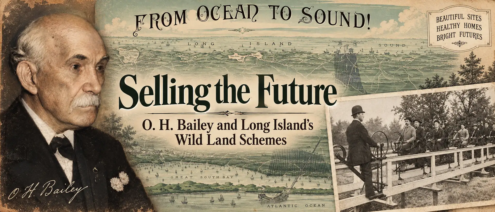
In the late 19th century, speculative developers transformed vast stretches of Long Island into thousands of building lots—at least on paper. This article explores how promoters used spectacular bird’s-eye views, many associated with O. H. Bailey, to sell an enticing vision of new towns and suburban prosperity that sometimes became reality, and sometimes amounted to little more than an elaborate land scam.
Kevin J Brown • September 15, 2026
In the late 19th century, a startling series of bird's-eye views began to appear, many associated with the established - and today legendary - American viewmaker Oakley Hoopes Bailey (1843 - 1947). They depicted a Long Island undergoing spectacular transformation: streets carved through forests, new neighborhoods spreading across the pine barrens, railroads connecting distant settlements, and entire towns seemingly rising from empty land. But much of what these views showed did not yet exist. They belonged to a speculative real-estate boom that ranged from legitimate development to audacious land scams in which promoters turned near-valueless scrubland into paper towns, selling thousands of building lots to working-class New Yorkers eager to buy into the future. Some of those schemes produced real communities; others left buyers holding deeds to inaccessible patches of wilderness. The remarkable views that survive capture the seductive space between development and speculation, scheme and scam, and the Long Island that existed and the one promoters promised.
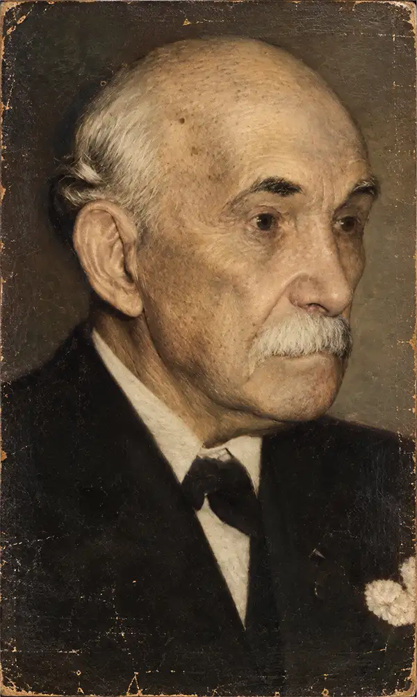
At the center of this phenomenon was a special sub-genre of the bird's-eye view: a perspective image showing not what existed, but what a place might become. Few American viewmakers were better suited to this peculiar art than O. H. Bailey. Bailey was a master at manipulating perspective, often combining multiple viewpoints into sweeping panoramas that could never be physically achieved. More importantly, he possessed the imagination to integrate proposed streets, buildings, railways, and entire neighborhoods into recognizable landscapes. This ability to map both the present and the possible made Bailey invaluable to legitimate developers and schemers alike.
Long Island for Sale
The Brooklyn Daily Eagle revealed the scale of the phenomenon on March 7, 1897, in an extraordinary exposé titled Wild Long Island Land Schemes: A Rich Field for Unscrupulous Speculators. The newspaper estimated that in Suffolk County alone land speculation companies had sold at least 150,000 lots during the preceding 20 years, taking in nearly $4 million (roughly $160 million in modern terms). Much of the underlying property lay in the broad belt of sandy pine and scrub-oak extending across central Long Island, known generally as the Long Island Pine Barrens, where undeveloped land could be acquired at between 50 cents and $5 per acre.
The economics were compelling. A promoter might acquire or control thousands of acres of inexpensive land, divide each acre on paper into smaller "building lots," give the resulting development an optimistic name (Prosperity, New Riverhead, etc.), and sell parcels for $5, $25, $50, or even $100. Suddenly, land worth only a few dollars per acre could potentially generate thousands of dollars. The challenge was in convincing prospective buyers that they were purchasing a piece of a future suburb rather than an isolated patch of scrub.
The Map That Made the Town
Maps and bird's-eye views were essential to making that transformation believable. Survey plans imposed orderly grids of streets and numbered lots upon wilderness. Promotional literature emphasized nearby railroads, factories, waterways, and proposed transportation improvements. Bird's-eye views went further, allowing prospective purchasers actually to see the promised future: broad avenues, handsome houses, parks, hotels, factories, railways, and prosperous neighborhoods stretching across the landscape.
The Eagle specifically criticized the promotional imagery used by the Riverhead Investment Company. Its admittedly spectacular (and unsigned) bird's-eye view revealed a handsomely organized town with a magnificent park (landscaped to rival Central Park) and lakeside hotels. The established community of Riverhead appeared close at hand and, seemingly within easy reach, the Long Island Sound, the Atlantic, Long Island Railroad, and Shelter Island (actually some 23 miles distant).
Such views traded on both imagination and the established authority of the bird's-eye view, a genre that tied its reputation to accurate depictions of real places. But these images were something different. They were not simply records of what a visitor would encounter on the ground; they blurred the boundary between observation and aspiration, presenting proposed streets, buildings, railroads, and entire communities with the same visual certainty as features that already existed. They were, in effect, visual arguments for what a place was promised to become.
H. O. Bailey: Mapping What Might Be
This was precisely the kind of cartographic problem Bailey was uniquely equipped to solve. Even his conventional city views often used extremely high oblique perspectives and shifting viewpoints that turned observed geography into imaginative reconstruction. Bailey was less constrained than many viewmakers by what could actually be seen from a hill, tower, or balloon; rather, he understood how to construct a landscape.
That skill allowed him to incorporate real and proposed geography seamlessly. A projected road could continue naturally through an existing landscape; empty property could become orderly blocks; planned houses could populate new streets. Bailey could take information from maps, surveys, plans, and observations and transform it into a coherent image.
Such prospective views were not inherently deceptive. Bailey produced many views for legitimate developments, including Watchung Heights and Atlantic Highlands in New Jersey, where much of the proposed infrastructure ultimately materialized. After all, every new development begins as an idea: streets are laid out before houses line them, and transportation links are proposed before commuters arrive. The prospective view gave buyers a compelling way to visualize that future. Yet the very quality that made these images so effective, their ability to make possibility appear tangible and imminent, also made them powerful instruments of speculation. In unscrupulous hands, the distance between reasonable projection, extravagant promise, ambition, and outright deception was a thread.
From Ocean to Sound!
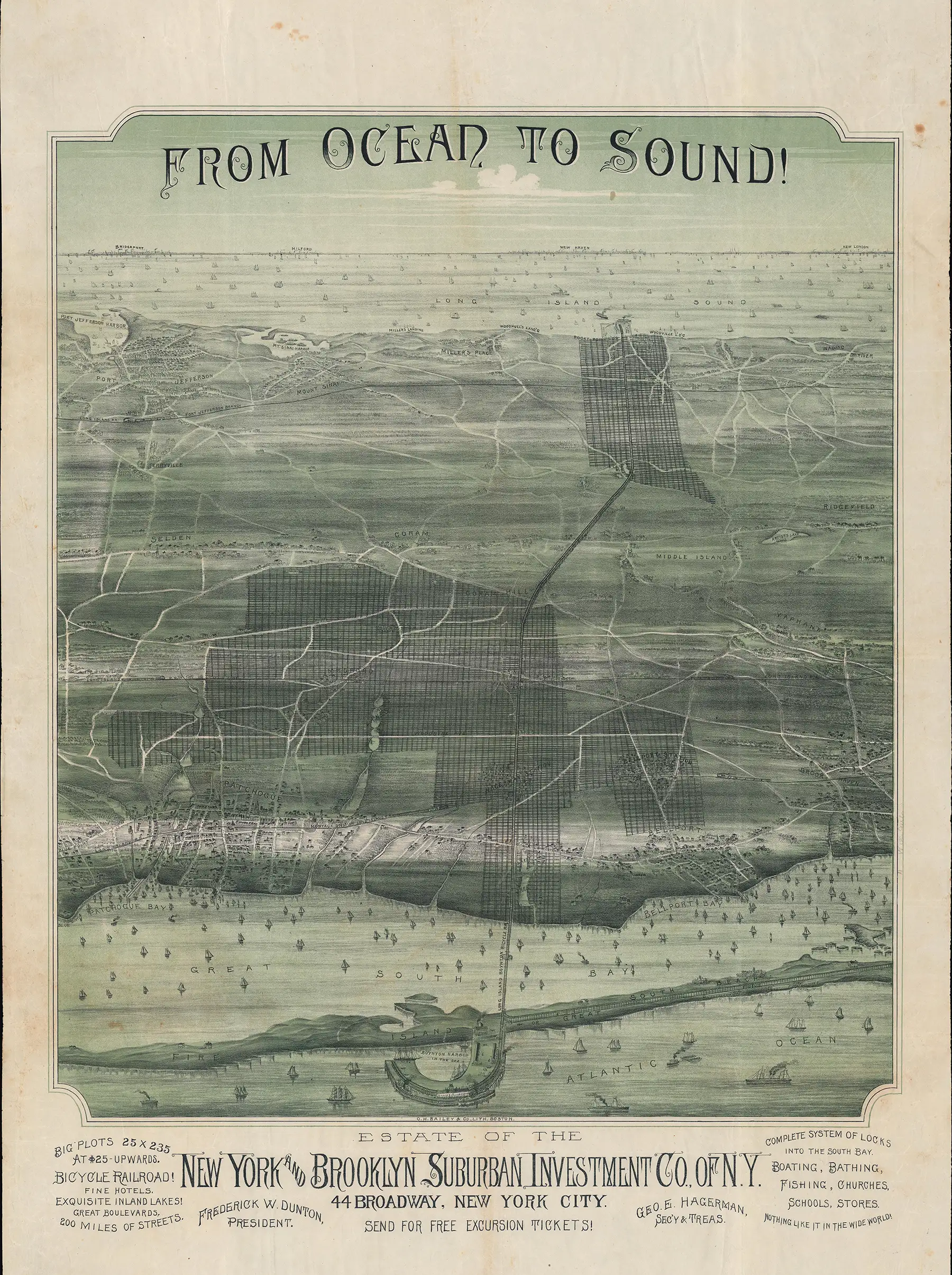
Around 1892, Bailey produced one of the most extraordinary surviving artifacts of the Long Island speculation boom, a large chromolithographic panorama titled From Ocean to Sound! Commissioned by the New York and Brooklyn Suburban Investment Company, the view looks northward across a broad swath of Suffolk County, from Fire Island and the Great South Bay toward Long Island Sound and the Connecticut shore beyond. Patchogue, Bellport, Brookhaven, Medford, Coram, Selden, Middle Island, Rocky Point, Mount Sinai, and Port Jefferson are incorporated into a single sweeping vision of eastern Long Island.
Much of Bailey's landscape was real. The established towns were real; the beaches and bays were real; the Long Island Railroad was real; and New York City's rapidly expanding population was real. Across this recognizable geography, however, Bailey superimposed sprawling grids of proposed building lots, visually connecting undeveloped property with established communities, transportation routes, and coastal amenities.
That combination is what makes From Ocean to Sound! so persuasive. Bailey does not isolate the speculative developments as disconnected subdivisions surrounded by wilderness. Instead, they appear as the natural continuation of an already developing landscape, woven into the same visual world as Patchogue, Port Jefferson, Fire Island, Long Island Sound, and the railroad. To a Brooklyn resident considering a $10 building lot, the picture offered more than a surveyor's plat: it showed what an investment might become.
The Company Behind From Ocean to Sound!
The New York and Brooklyn Suburban Investment Company was no minor operator. According to the Eagle, it controlled some 11,258 acres extending across Long Island from the Montauk Division of the Long Island Railroad toward Long Island Sound, including property around East Patchogue, Patchogue, Bellport, Woodville, West Yaphank, Waverly, Farmingdale, and Rocky Point. More than 15,000 deeds had been recorded, with ordinary lots generally selling for $10 to $15 and corner lots commanding $30 to $50.
This enormous operation helps explain the cartographic ambition of From Ocean to Sound! It visually assembled a vast portfolio of scattered landholdings into a coherent development corridor.
Not every aspect of the company's operations was fraudulent. Some roads had actually been opened, and the company represented a much more substantial undertaking than many of Long Island's ephemeral land schemes. Nevertheless, the tremendous disparity between the inexpensive underlying acreage and the thousands of individually marketed building lots illustrates the speculative economics driving the entire industry.
Bicycle Railroad That Would Make It All Possible
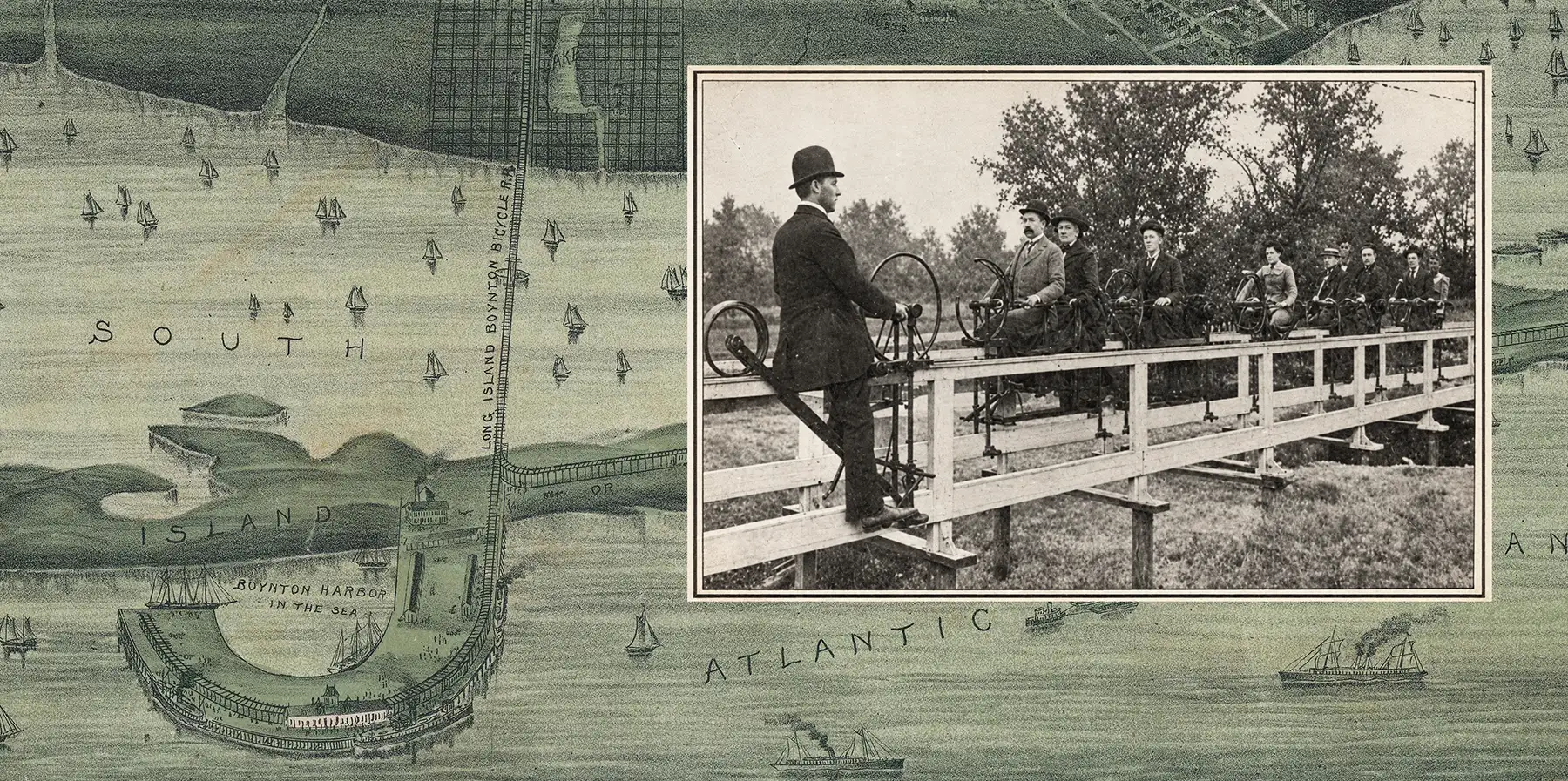
Bailey's panorama also prominently depicts a north-south transportation link crossing Suffolk County between the Great South Bay and Long Island Sound: the proposed Long Island Boynton Bicycle Railroad. Developed by inventor Eben Moody Boynton, this extraordinary experimental railway used narrow trains running on wheels aligned along a single ground rail, stabilized by smaller wheels against an overhead guide.
The Boynton Railway was not imaginary. Experimental versions operated around Brooklyn, and financial interests associated with Long Island development backed a test track between East Patchogue and Bellport in 1894. Passenger service briefly operated on the experimental Suffolk County line, and Scientific American reported on the project that February.
What never materialized was the ambitious cross-island system suggested by the promotional view. The railway encountered financial and practical difficulties, as well as opposition from the Long Island Railroad, whose established network it would have needed to cross. Funding disappeared, and the experimental line was dismantled in 1902.
For a prospective land buyer in the early 1890s, however, the Boynton Railway represented possibility. Remote, inaccessible acreage could become valuable almost overnight if a new railway connected it to established communities. By depicting the proposed Boynton line alongside existing towns and established railroads, Bailey gave a speculative transportation project the visual weight of existing infrastructure.
From Development to Land Scheme
The Eagle was careful to distinguish legitimate speculation from outright fraud. Many real communities, such as Bohemia, Lindenhurst, and Holbrook, emerged from successive waves of subdivision and land promotion. Other companies genuinely surveyed their property, staked lots, built roads, or sold acreage suitable for agriculture.
Elsewhere, however, the gulf between the town depicted in views and the land itself could be astonishing. Grand avenues and orderly blocks shown on promotional maps and views might in fact remain unbroken scrub; streets remained unopened, and lots unstaked such that most purchasers could not even locate their supposed property. Worse still, entire developments sometimes remained burdened by underlying mortgages, meaning that a buyer could hold a genuine deed to an individual lot and still lose everything when the larger tract was foreclosed. In the worst schemes, the property scarcely existed beyond the deed, which itself was often unrecorded and fraudulent.
The sheer variety of companies and developments documented by the Eagle reveals the scale of the phenomenon:
| Company / Promoter | Development / Location | What the Brooklyn Eagle Says |
|---|---|---|
| Great Suburban Improvement Company of New York | New Riverhead | Controlled roughly 1,000 acres across the Peconic from Riverhead. Offered "free" lots and sold others for $25–$100. Buyers arriving on an excursion encountered scrub oak, sand, pine, and poorly defined lots. |
| New York and Brooklyn Suburban Investment Company | East Patchogue, Patchogue, Bellport, Woodville, West Yaphank, Waverly, Farmingdale, Rocky Point | One of the largest operators. Controlled 11,258 acres and recorded more than 15,000 deeds. Lots generally sold for $10–$15, with corner lots bringing $30–$50. |
| Riverhead and Brookhaven Company / Riverhead Investment Company | Southampton / Riverhead area | Together disposed of about 7,000 lots. Promotional imagery showed parks, hotels, Riverhead, the Sound, Atlantic, and even distant Shelter Island appearing nearby. |
| Eastport Land and Improvement Company | Eastport | Controlled about 600 acres, assessed at roughly $2 per acre. Hundreds of deeds were recorded and thousands of lots conveyed at $5 and upward. |
| Metropolitan Investment Company | Edgemere / Edgewood, near Deer Park | Controlled roughly 700–750 acres and sold perhaps 8,000–10,000 lots at around $25 each. Streets were laid out and lots staked. |
| Long Island Homestead Investment Company | Lake Grove | Controlled about 30 acres, assessed at $1 per acre, and sold numerous building lots. |
| Unclear / changing ownership | City of Prosperity | A development between Moriches and Middle Island Road located, in the Eagle's memorable description, "in the scrub oaks." |
| Moriches Land and Improvement Company | City of North Moriches | The property apparently was not actually subdivided on the ground; the newspaper also questioned the company's corporate documentation. |
| Mary J. Fanning / Emma M. Hageman | Lovely Park, near Riverhead | Some 265 acres assessed at only $300 altogether. Approximately 700 lots sold for $5–$10. The newspaper called it "almost an uninhabited wilderness." |
| Long Island Investment Company / Various Promoters | Lakeland and Holbrook | Thousands of lots were sold from heavily mortgaged tracts. Foreclosures subsequently caused purchasers to lose their investments. |
| M. J. Byrnes / Hester A. Byrnes | Avonmore Park, near Ronkonkoma | Roughly 400 lots were sold. |
| Deer Park Investment Company | Deer Park | Controlled 5,650 acres, assessed at about $7,800 total. Thousands of lots apparently sold for $25–$50. |
| United States Land and Improvement Company | Lindenhurst area | Controlled 281 acres, assessed at only $81 total. About 3,000 lots sold for $10–$60 before foreclosure ultimately cost purchasers their investments. |
| Wyandance Springs Company | Wyandance | Controlled 577 acres. The Eagle was considerably less critical here and described much of the property as suitable building land. |
| William Mofft / Agricultural Land Company / Daniel L. Risley | Wampmissic, Yaphank, Miller's Place and other areas | Represented the newer five-acre farm model. Some of these parcels were properly surveyed and suitable for genuine agricultural development. |
| Robinson and associates | Quogue plains / "Grant" tract | Bought approximately 1,200 acres for 50 cents per acre and promoted it using the prestige of Ulysses S. Grant, who briefly invested before discovering the property's actual value. |
| Charles Wood | Lakeland, Irvington, Hermanville, Rosedale, Ronkonkoma, etc. | An earlier speculator who filed more than 30 town maps, advertised internationally, and sold thousands of lots. Mortgage foreclosure eventually wiped out many purchasers. |
| Thomas Wellwood / Charles S. Schleier | Breslau → Lindenhurst | Thousands of lots were sold in a projected city. Financial and mortgage problems caused serious losses, although the settlement ultimately developed into Lindenhurst. |
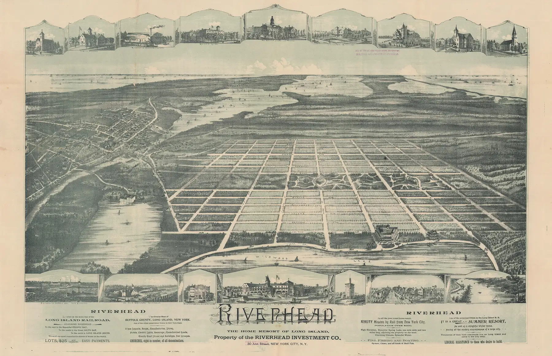
New Riverhead: When the Buyers Came to See Their Town
No episode better illustrates the Long Island Land Boom's darker side than the Great Suburban Improvement Company's New Riverhead development. The company advertised 25-by-100-foot building lots and even offered "free" lots through newspaper coupons, charging recipients about $4.79 to prepare and record the deed (the actual cost was about $1 per deed). Once a buyer accepted a free property, he was encouraged to purchase the adjoining lot that had conveniently been "reserved."
New Riverhead was promoted as a suburb of the prosperous manufacturing town of Riverhead, near the "navigable" Peconic River. They also promoted that it would soon benefit from an electric railway that would supposedly put it within about 40 minutes of New York City.
The company eventually organized an excursion so purchasers could inspect their holdings and buy additional property. It is not clear why the company thought this was a good idea. What buyers discovered was far different from what they believed they bought.
The Eagle described a wilderness of "practically trackless sand, huckleberry bushes, scrub oak and stunted pine." "Broadway", New Riverhead's main thoroughfare, was a rough wagon track cut through the brush, beyond which there were so few markers that purchasers became lost while searching for their lots. Most could not locate their property at all. One Brooklyn tailor who owned a lot identified on the company's map as 51 Grand Avenue asked a clerk where it was and received little more than a wave toward the wilderness.
The excursion ended spectacularly. Furious investors turned on the company's representative, who was forced to seek protection from the county sheriff and eventually fled, pursued by rocks and insults. On their 75-mile return journey to Brooklyn, the purchasers contemplated advertisements describing New Riverhead as "near the border of Greater New York" and reportedly joked that the promised 40-minute electric railway "will probably be of the aerial kind."
Deed to Somewhere (or Nowhere)
New Riverhead illustrates one of the strangest features of the boom: a purchaser could possess a deed yet have only the vaguest idea of what he actually owned. Streets shown on subdivision plans might not exist on the ground, lots might not be staked, and reaching an individual parcel could be nearly impossible.
Evidence surrounding the Riverhead developments also suggests that most parcels were sold more than once, leaving multiple buyers believing themselves the legitimate owner. The property's remoteness made such competing claims extraordinarily difficult to unravel, much less resolve. The land's intentional inaccessibility was thus turned to the unscrupulous promoter's advantage: buyers were unlikely to occupy or fence their property, and in most cases could not even find their lots.
Another danger was more straightforward. Entire developments remained subject to underlying mortgages. A purchaser could receive a genuine deed to an individual lot, yet lose everything if the developer defaulted and the larger tract was foreclosed. The Eagle documented this pattern around Lakeland, Holbrook, Lindenhurst, and in earlier speculative developments dating back to the 1840s.
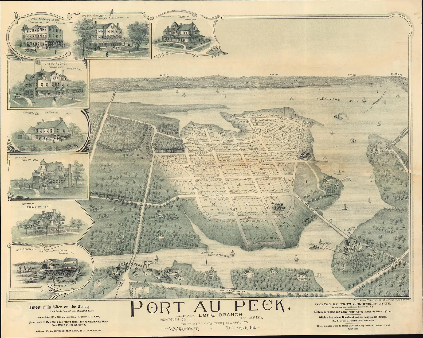
Bailey and the National View Company
Against this background, Bailey's apparent relationship with another producer of prospective real-estate imagery bears some speculation. Views such as Port-au-Peck, issued by the National View Company of 36 Columbus Avenue, Boston, share notable stylistic characteristics with Bailey's work: similar lettering, treatment of trees, decorative flourishes, and a characteristic printing style combining light blue and black with chromolithographic color.
The National View Company specialized in exactly the sort of prospective real-estate views at which Bailey excelled. Yet Bailey's imprint does not appear on any of these images. Stylistic evidence alone cannot establish authorship, but the similarities, subject matter, and Bailey's documented involvement in comparable projects make a connection plausible.
Bailey may also have had good reason to distance himself from such commissions - the New Riverhead view is unsigned as well. Perhaps he knew that particular projects were questionable or understood that not every ambitious development would emerge. There is no evidence that Bailey knowingly participated in fraudulent schemes, and many of the developments he illustrated were legitimate. But an experienced artist working repeatedly in this field could hardly have been unaware of the difference between drawing what existed and drawing what a promoter hoped - or claimed - would exist.
Drawing Tomorrow
That distinction ultimately explains both Bailey's importance and the fascination of these views. A prospective real-estate map was not necessarily fraudulent. Atlantic Highlands, Watchung Heights, Lindenhurst, and other developments demonstrate that speculative planning could lead to genuine communities. Streets have to be planned before houses are built, and every suburb exists on paper before it exists on the ground.
But Long Island's land boom reveals how powerful and dangerous that visual language could become. A few dollars' worth of scrubland could be surveyed into "Grand Avenue," "Broadway," parks, residential blocks, and numbered building lots. Add an existing railroad, a proposed railway, nearby towns, steamships, beaches, and the glittering waters of Long Island Sound, and the same land acquired an entirely different identity.
From Ocean to Sound! captures that transformation at its most ambitious. Bailey combined real geography with speculative development so effectively that the boundary between Long Island as it was and Long Island as it might become disappears. The map did not simply illustrate the property being sold; it helped manufacture the future upon which the property's value depended.
That may be Bailey's particular genius as a viewmaker. He did not merely draw places. He could draw tomorrow.
Related Posts and Information
https://www.geographicus.com/P/AntiqueMap/riverheadlongisland-bailey-1893
https://www.geographicus.com/P/AntiqueMap/longisland-bailey-1892
https://www.geographicus.com/P/AntiqueMap/portaupecknj-nationalview-1894
https://www.geographicus.com/P/RareMaps/baileyoakelyhoopes
https://www.newspapers.com/article/brooklyn-eagle-wild-long-island-land-sch/206004720/