
Animals Take Over the Map: Baloghné Hajós Terézia and the Art of Teaching Through Cartography
Baloghné Hajós Terézia, Pioneering Hungarian Educator Teaching Through Cartography
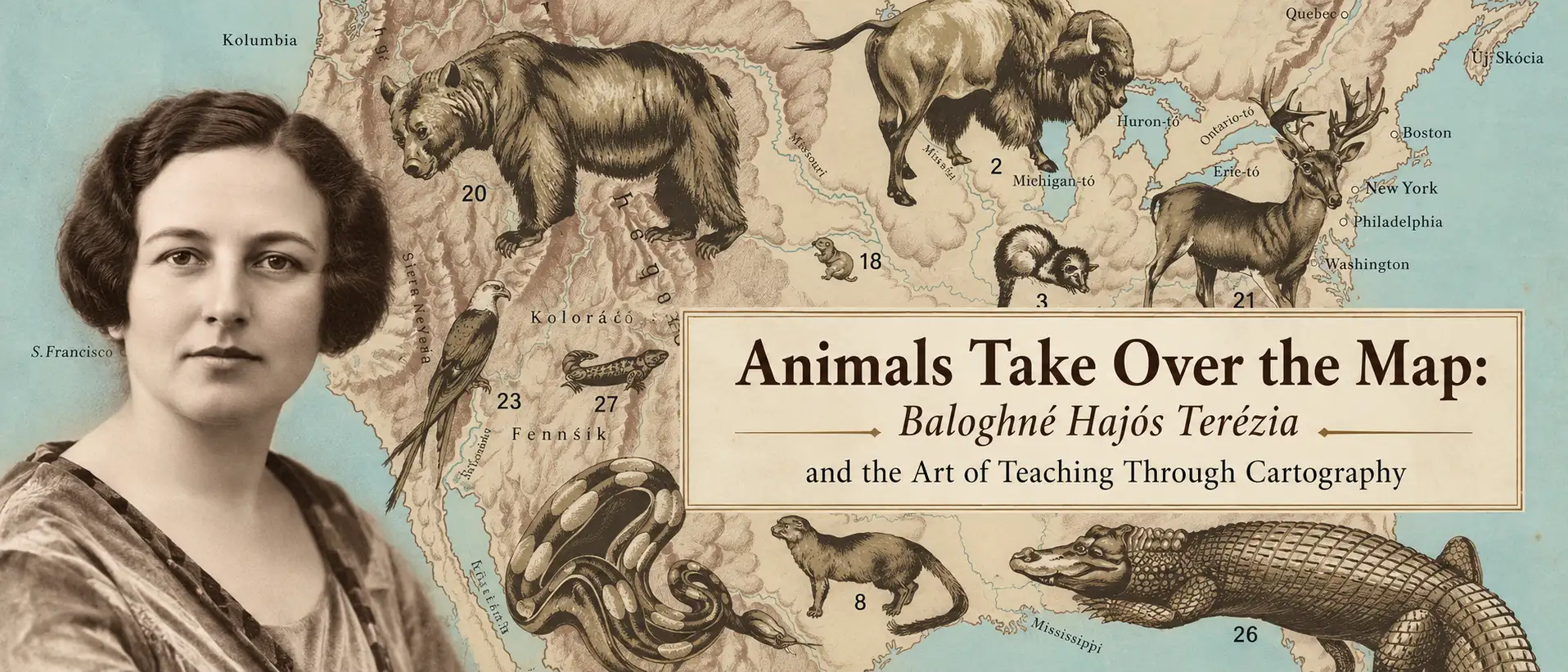
Enormous animals turn geography into discovery in the pictorial maps of Hungarian educator Baloghné Hajós Terézia. Explore how her remarkable animal maps and zoological atlas brought wildlife into the classroom, combining natural history, bold illustration, and cartography to spark curiosity about the world.
Kevin J. Brown • September 28, 2026
Hungarian educator and biologist Baloghné Hajós Terézia recognized that learning begins with curiosity—and that curiosity can be sparked by fascination. A pioneering woman in science education, she sought to capture her students' imaginations through vivid visual teaching aids that invited questions and encouraged discovery. Her remarkable suite of animal wall maps brought that vision to life, transforming classroom walls into bold, colorful windows into the animal world.
Her most ambitious experiment in visual education was the Állat-térképek, or 'Animal Maps,' a series of six enormous zoological wall maps developed during the 1920s with illustrator Bálint János. Terézia's idea was simple but effective: instead of asking students to learn animal geography from text, tables, or small symbols on conventional maps, she let the natural world dominate the cartographic medium: whales would fill oceans, elephants would stride across Africa, tigers would occupy Asia, and bears would loom over North America. Geography provided the framework, but the animals commanded attention.
Her methodology produced one of the most striking educational cartographic projects of the Interwar Period (1918 - 1939). Covering Hungary, Europe, Asia, Africa, North America, and a combined South America and Australia, the six-map suite subordinated political geography to zoology. Borders largely disappeared, though some cities, as well as key rivers, mountains, and other geographical features remained. Striding over them (or, in some cases, swimming in them), her partner Bálint boldly illustrated the most impressive and inspiring vertebrates, dramatically enlarged but positioned roughly within their geographical ranges.
Yet spectacle was not the ultimate objective. Terézia was attempting to solve a pedagogical problem: how to foster intellectual curiosity?
Baloghné Hajós Terézia: Making Science Accessible
Born Terézia Hajós in Veszprém in 1884, Terézia earned her teaching diploma in Budapest in 1908 and then entered a profession that let her combine two abiding interests: education and the natural sciences. After several years teaching outside the capital, she joined Budapest's civic-school system and became involved in communicating zoology and natural history to younger audiences.
Her approach extended well beyond conventional classroom instruction. By 1918, she had published a textbook on zoology and botany for civic schools, and she later collaborated on additional educational works on zoology, botany, and health. She also wrote children's literature, popular natural-history books, pedagogical and scientific articles, and later brought animal stories to the relatively new medium of radio. Works such as Harc az életért (The Struggle for Life, 1928), A tornyos villa lakói (The Inhabitants of the Towered Villa, 1931), and Az állatok beszélnek (The Animals Speak, 1936) reveal a consistent interest in presenting nature through observation, narrative, and imagination rather than through taxonomy alone.
The animal maps emerged naturally from this larger educational project. A biographical account published during Terézia's lifetime states that she had conceived her animal maps as early as 1917, suggesting that the spectacular wall-map series of the late 1920s represented the culmination of a concept she had been developing for roughly a decade. The objective was not simply to put zoological information onto a map; rather, it was to make that information memorable and inspiring.
Terézia's achievement is particularly significant in the context of women's changing role in Hungarian intellectual and professional life during the early 20th century. Teaching had long offered educated women a path to professional employment, but women increasingly participated in scientific scholarship, publishing, journalism, and the communication of specialized knowledge. Terézia went a step further. She was not merely transmitting scientific information assembled by others; she was developing original and novel didactic methodologies.
A Map Designed to Be Remembered
On Terézia’s maps, enormous and exotic animals command the scene, turning geography into a mechanism for exploring the zoological world.
Rather than adding small zoological symbols to otherwise conventional maps, Terézia and Bálint reversed the hierarchy. Animals overwhelm the cartography. Exaggeration was fundamental to the maps' pedagogical purpose. These were classroom wall maps, meant to be seen from across a room and, at the same time, imprint themselves on a student's imagination.
Hungarian zoologist Lajos Soós recognized Terézia's innovative approach when he reviewed the series in 1928. He understood the maps principally as pedagogical rather than strictly scientific works, intended to acquaint students visually with the characteristic vertebrates of Hungary and the wider world. Soós also identified a key strength of the concept: repetition without effort. A textbook disappears when it is closed. A wall map remains in front of the student. Seen repeatedly during lessons and throughout the school day, its animals, locations, and associations could gradually become fixed in memory.
The Állat-térképek were not designed to provide the final word on where an animal lived. They were designed to begin a conversation. What is that animal? Where does it actually live? Why does it live there? What kind of environment does it require?
This tension between scientific precision and visual imagination is central to their pedagogical power. A child who might pass an ordinary geographical map without a second glance would have difficulty ignoring an enormous tiger, elephant, whale, bear, or crocodile staring down from the classroom wall. Once attention had been captured, investigation could begin. Terézia understood that education begins not merely with transmitting facts, but with inspiring the desire to know.
Bálint János: Giving Terézia's Idea Visual Power
Terézia found an ideal collaborator in Bálint János (1885 - c. 1940), the Hungarian sculptor, graphic artist, and illustrator responsible for the maps' extraordinary animal imagery. Born in Csíkgyimesbükk, today Ghimeș-Făget in Romania, Bálint studied at the Országos Magyar Királyi Mintarajziskola and worked across caricature, book illustration, periodical graphics, and educational illustration.
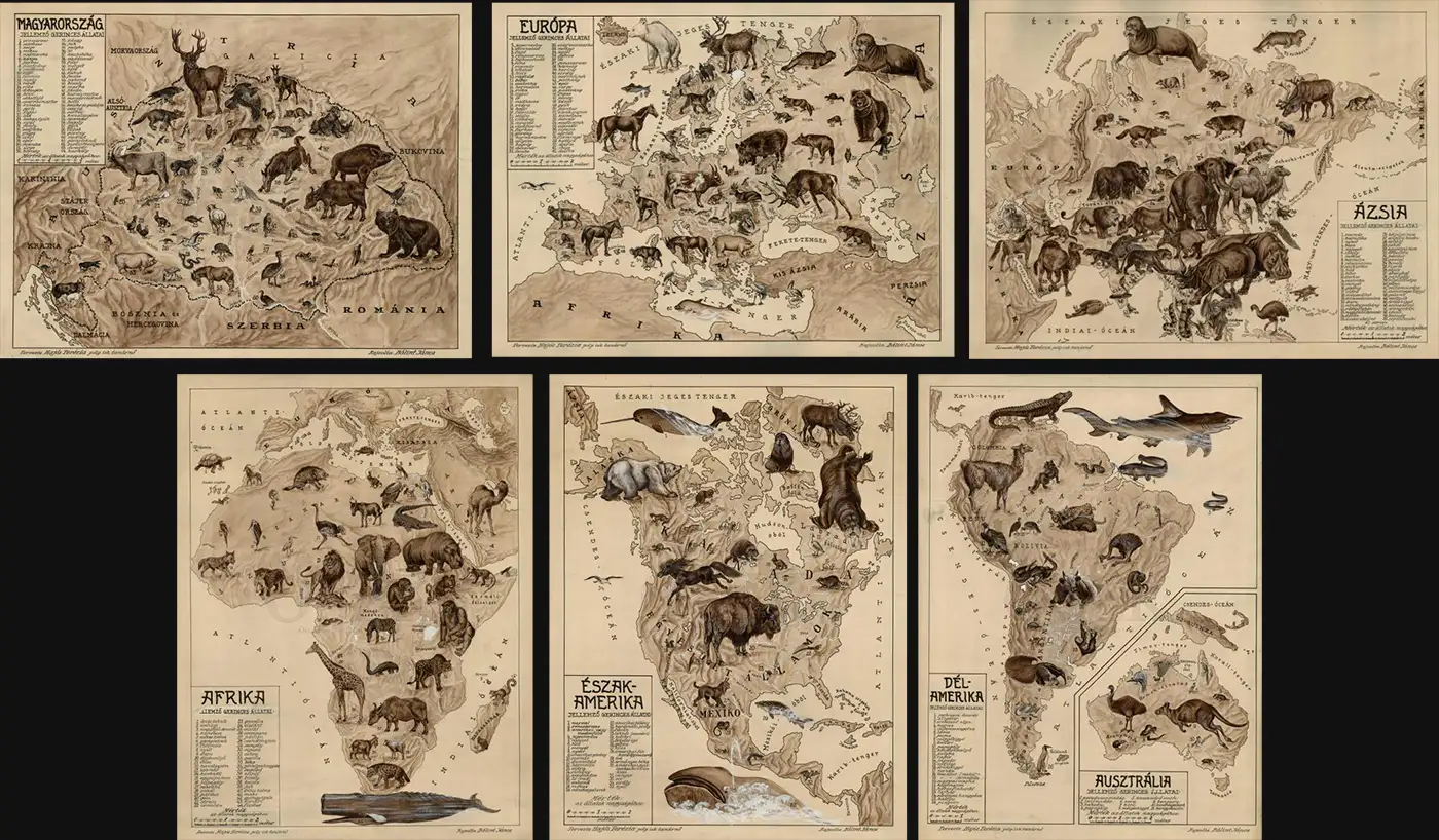
His task required an unusual balance. The animals needed enough anatomical credibility to function educationally, yet enough character and graphic force to dominate enormous classroom maps. Terézia provided the zoological and pedagogical conception; but Bálint translated it into a visual language capable of commanding a classroom. Remove the animals and the underlying maps are comparatively simple. Remove the geography and the animals lose their spatial meaning. Remarkably, Bálint's original artwork survives at Hungary's Országos Széchényi Könyvtár (National Széchényi Library), showing how the final maps underwent significant revision - whether by his hand or someone else's is unclear.
From Educational Experiment to National Classrooms
The publication chronology of the Állat-térképek series is somewhat confused. Terézia was experimenting with the concept as early as 1917, while surviving maps and contemporary references associate the mature project with 1926-28. The series received official Ministry of Religion and Public Education approval in 1927 (73.425/1927), and by 1928 all six maps were being promoted for classroom use.
Under decree 4963/1928 VIII/b, the Hungarian Ministry of Religion and Public Education formally called upon elementary schools to adopt the new animal maps. The Magyar Királyi Állami Térképészeti Intézet (Royal Hungarian State Cartographic Institute) produced the maps and distributed them through the publishing firm founded by Kókai Lajos, then directed by his son, Kókai Rezső. Their production by the state cartographic establishment and formal approval for educational use underscore their contemporaneous pedagogical significance. They were also promoted to the private sector; we note a contemporary advertisement promoting the six sheets individually, both unmounted and prepared as conventional wall maps.
The Állatföldrajzi Atlasz: From Classroom Wall to Student's Desk
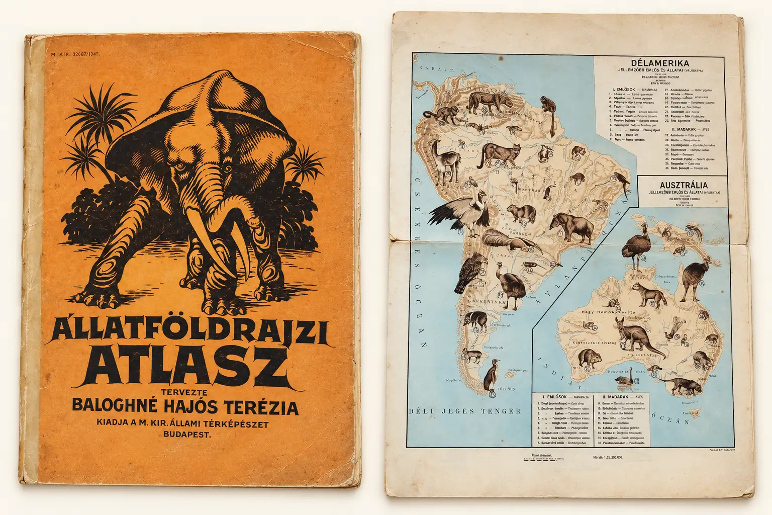
Terézia extended the same concept to a smaller format in 1928, when she issued the Állatföldrajzi atlasz (Zoogeographical Atlas), Hungary's first zoological atlas. The work translated Bálint's commanding wall-map imagery into a smaller, simplified format suitable for individual study. The atlas nonetheless followed the same geographical scheme: Hungary, Europe, Asia, Africa, North America, South America, and Australia. The atlas's publication underscores the ambition of Terézia's project. She was not merely designing educational classroom decorations; she was developing a coherent program for teaching animal geography.
One encouraged study. The other created spectacle and memory.
Six Windows on the Animal World
Together, the six Állat-térképek form a remarkable visual survey of vertebrate life. Although unified by Terézia's pedagogical concept and Bálint's distinctive illustrations, each sheet maintained its own character from the geography and fauna represented.
Hungary - Magyarország jellemzőbb gerinces állatai
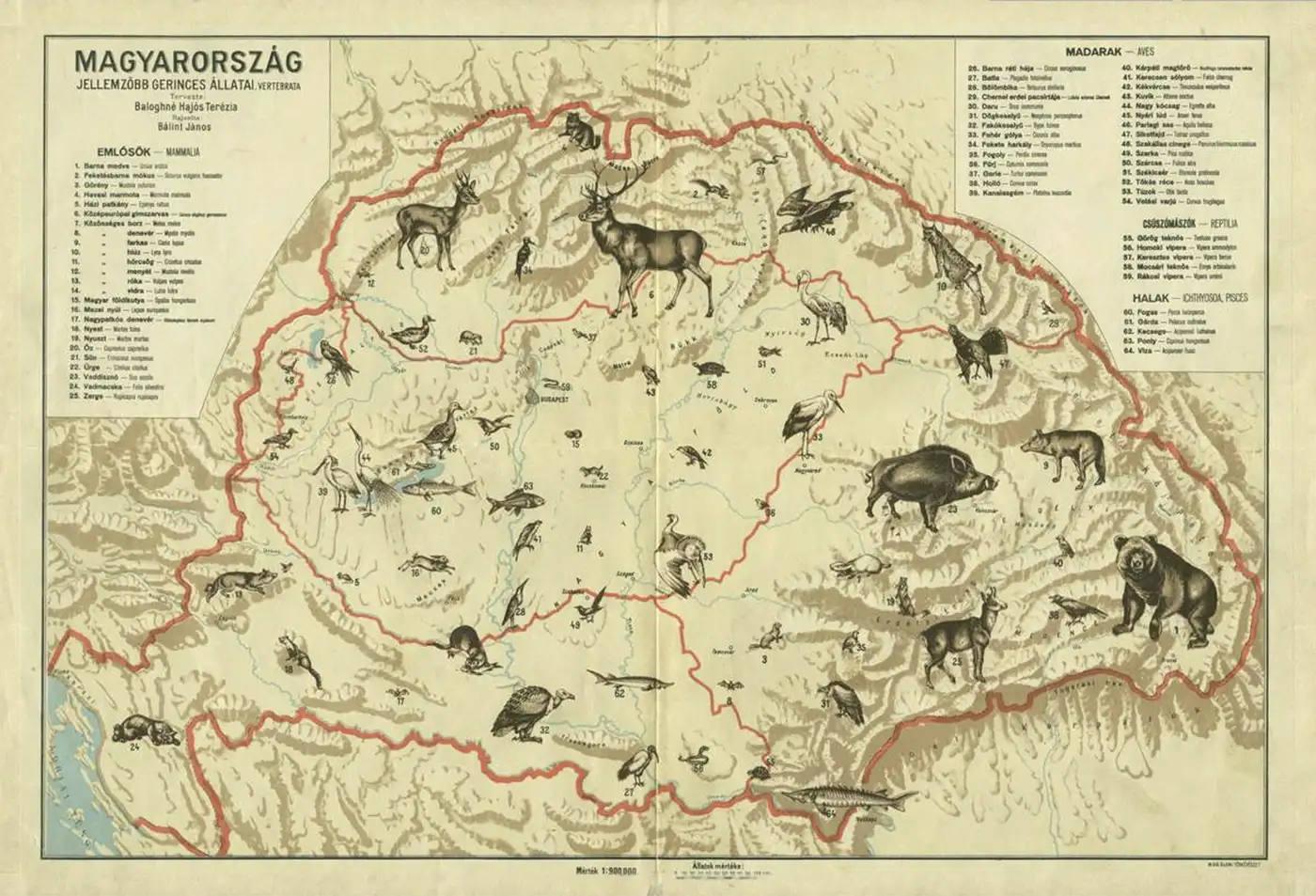
At 1:900,000 and containing 64 animals, the Hungary map is the most densely populated sheet in the series. Here Terézia turned her pedagogical method toward the familiar, teaching Hungarian students to recognize the wildlife of their own country before looking outward to more distant regions. Its comparatively large scale allowed an especially rich relationship between fauna and geography, making the map an introduction not just to zoology but to Hungary's biological character.
Europe - Európa jellemzőbb gerinces állatai
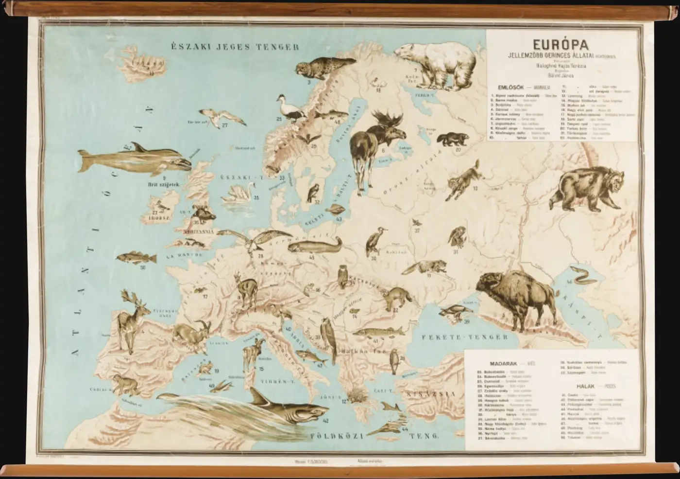
The Europe map presents 50 characteristic vertebrates at a scale of 1:5,000,000. Its subject presented a different challenge from the more visually exotic continental sheets, since many European animals were already familiar to Hungarian students. The map therefore places recognizable species into a broader geographical context, encouraging students to understand animals not as isolated creatures but as inhabitants of environmental systems.
Asia - Ázsia jellemzőbb gerinces állatai
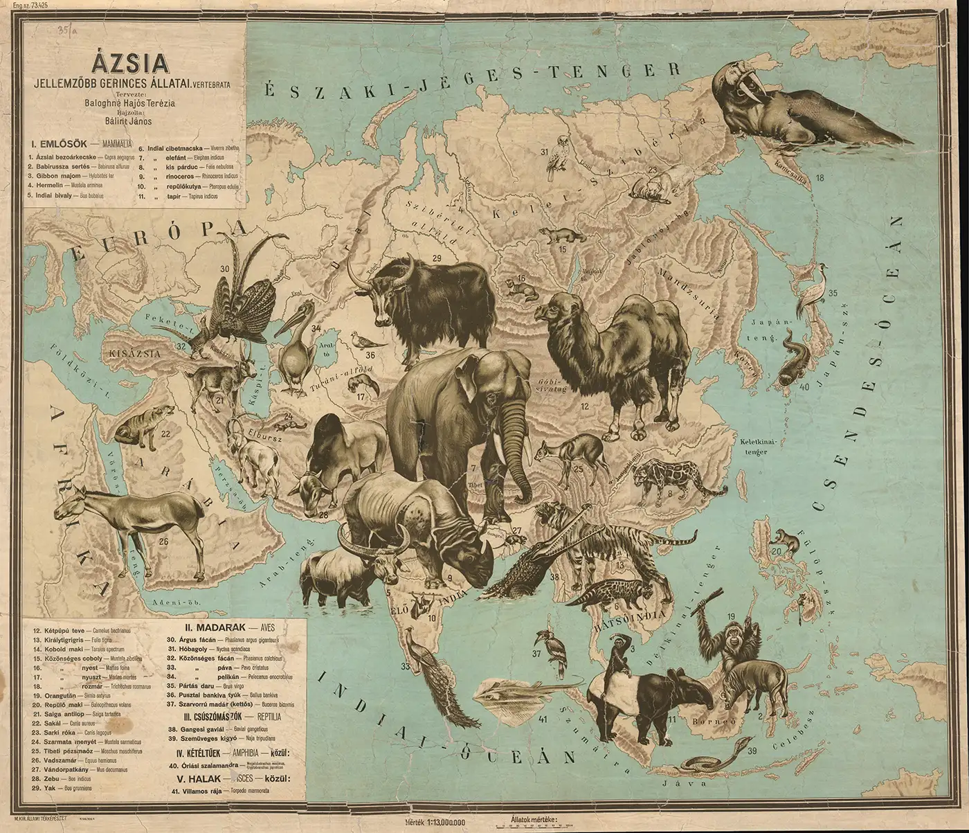
Asia becomes a spectacular procession of 41 vertebrates spread across the world's largest continent. Elephant, tiger, Bactrian camel, walrus, water buffalo, crocodile, peacock, cobra, orangutan, rhinoceros, and giant salamander are among the creatures that overwhelm the simplified geographical framework. Their exaggerated scale transforms an immense and potentially abstract continent into a sequence of memorable living forms: a world of tigers, elephants, camels, reptiles, birds, and marine mammals.
Africa - Afrika jellemzőbb gerinces állatai
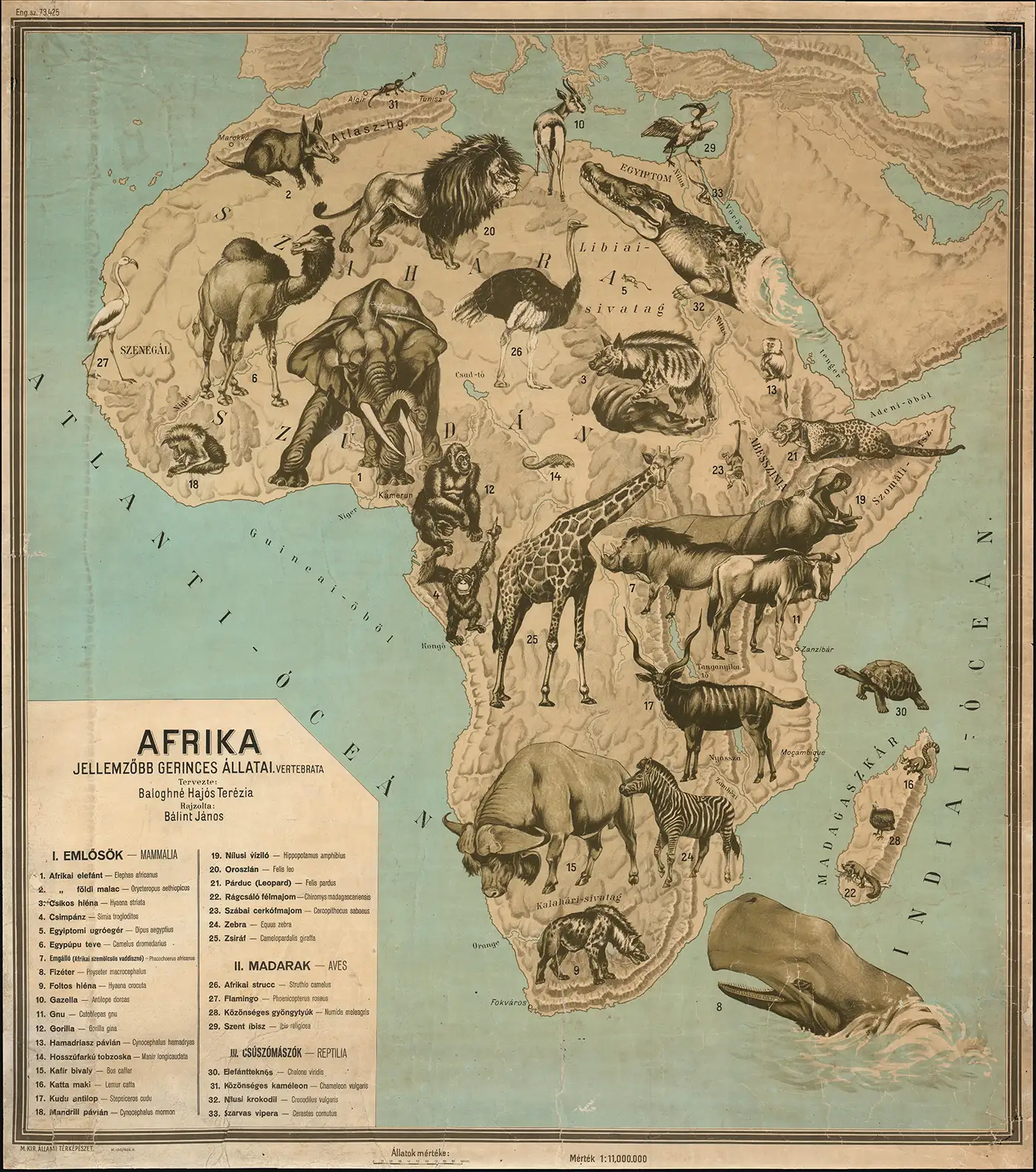
Few subjects suited Terézia and Bálint's visual methodology better than Africa. 33 vertebrates dominate the sheet, including elephants, lions, giraffes, sperm whales, Nile crocodiles, water buffalo, hippopotamuses, ring-tailed lemurs, camels, aardvarks, chimpanzees, gorillas, ostriches, and flamingos. Rivers and lakes remain sufficiently prominent to orient the viewer, but the continent is fundamentally defined by its animals. The result is perhaps the purest expression of the series' central idea: geography transformed into a panorama of life.
North America - Észak-Amerika jellemzőbb gerinces állatai
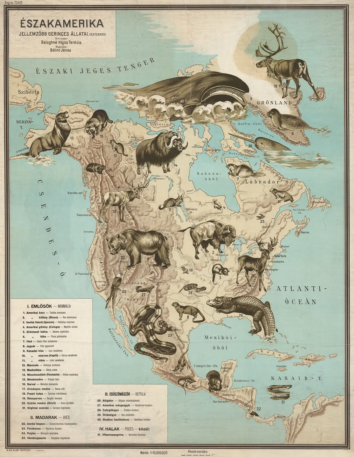
31 dramatically illustrated vertebrates populate the North America map. A great bowhead whale commands the Arctic waters, an enormous alligator sprawls across Florida and the American South, and a formidable grizzly occupies the Rocky Mountains. Here the tension between visual drama and zoological precision is particularly apparent, including an electric eel appearing in the Caribbean despite belonging to the freshwater systems of northern South America. Even such inaccuracies illuminate the map's purpose: recognition, memory, and curiosity took precedence over exact scientific distribution.
South America and Australia - Dél-Amerika és Ausztrália jellemzőbb gerinces állatai
The final sheet is the most unusual composition in the series, combining South America and Australia on a single sheet at 1:10,000,000. Together the two regions contain 45 illustrated animals. The pairing allowed Terézia to complete her global survey within six wall maps while juxtaposing two geographically distant and zoologically distinctive regions. We have thus far been unable to locate a surviving example or sufficiently detailed image of this sheet, making it the most elusive in the series.
Why the Állat-térképek Matter
Animals have been represented on maps for centuries, and Terézia certainly did not invent either pictorial cartography or zoological mapping. What distinguishes the Állat-térképek is the inversion of the conventional relationship between illustration and cartography. On most maps, animals are additions to the geography; here geography exists to organize the animals. That reversal makes Terezia's maps unique. They are classroom maps, yet their compositions possess the exuberance of pictorial art. They communicate zoological information while deliberately sacrificing some precision for recognition, memory, and visual impact. Terézia recognized that a classroom wall map did not need to reproduce the density of an atlas page; rather, it could inspire curiosity by commanding the room.
The Állat-térképek occupy the intersection of cartography, natural-history illustration, zoological education, Hungarian publishing, classroom technology, and women's expanding participation in professional and intellectual life. Yet their greatest achievement may be considerably simpler: they instantly capture attention. Nearly a century after their creation, the maps provoke the same visceral reaction that Terézia hoped to elicit from her schoolchildren. The eye moves first toward an elephant, tiger, whale, bear, crocodile, or giraffe. Then it moves to the map. Where is that animal? Why is it there? What else lives nearby? And with those questions, the education has begun.
That is what makes the Állat-térképek more than curiosities of interwar Hungarian cartography. They are artifacts of one educator's philosophy: art attracts attention, cartography organizes knowledge, science supplies the subject, and curiosity does the rest.
Survival and Rarity
The maps are scarce today, which is unsurprising given their original purpose. They were working classroom objects, commonly mounted on canvas and rollers, hung and rehung, handled by generations of teachers, exposed to sunlight, and eventually discarded as their scientific and educational content became outdated.
Individual examples survive in Hungarian institutional collections and occasionally appear on the market, but we are unaware of a surviving complete six-sheet set. Geographicus has handled examples of the Asia, Africa, and North America maps, while institutional research has allowed us to identify examples of the Hungary and Europe sheets. The combined South America-Australia map remains particularly elusive. Reassembling the six maps today would therefore be a considerable challenge to the motivated collector - far more difficult than purchasing them in 1928!
The maps capture an ambitious moment when a pioneering Hungarian female educator, a gifted illustrator, and the resources of the state cartographic establishment came together to rethink the educational process.
Related Posts and Information
https://www.geographicus.com/P/RareMaps/baloghneterezia
https://www.geographicus.com/P/RareMaps/balintjanos
https://www.geographicus.com/P/RareMaps/magyarterkepeszet
https://www.geographicus.com/P/AntiqueMap/afrika-terezia-1928
https://www.geographicus.com/P/AntiqueMap/azsia-terezia-1928
https://www.geographicus.com/P/AntiqueMap/eszakamerika-terezia-1928