
Hammond, Caleb Stillson (sold)

Caleb Stillson Hammond (1862 - 1929) was the founder of C. S. Hammond & Company, a map making and printing firm based in Brooklyn, New York. Hammond started his career in mapmaking as the head of Rand McNally's offices in New York City, where he began working in 1894. Hammond split with Rand McNally, forming his own printing concern in Brooklyn, New York, in 1900. The firm was subsequently incorporated in 1901 and relocated to Manhattan, and then to Maplewood, New Jersey, near Hammond's family home. Hammond rose to become one of the largest cartographic publishers in the United States, second only to Rand McNally in volume. On his retirement, C. S. Hammond passed the firm to his son, who subsequently passed it to his own son, C. D. Hammond, who sold the company to Langenscheidt Publishers in 1999. The firm has since been folded into Universal Map, an affiliate of Kappa Publishing Group. This archives of the Hammond World Atlas Corporation, an invaluable resource, where donated to the Library of Congress in 2002.
Take a steamship to Florida from New York!
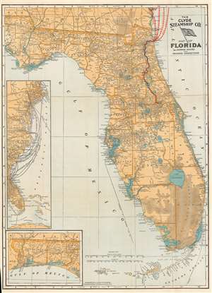
The Clyde Steamship Co. Map of Florida Showing Routes and Railroad Connections.
sold
- Digital Map Information
- Suitable for large format printing
- Full resolution TIFF file
- ICC color profile embedded
- Delivered instantly via download link
This is a 1903 Clyde Steamship Company map of Florida. Overprinted red dashed lines mark the Clyde Steamship Company's routes out of Jacksonville north to Charleston, New York, and Boston, as well as the St. John's River Line from the coast inland south along the river to Sanford. An inset map along the left border traces the company's many routes from their terminal in Florida to destinations along the coast. A second inset map, in the lower left, details the Florida panhandle from the Alabama border to Washington County. (more details)
Scarce view of New York City.
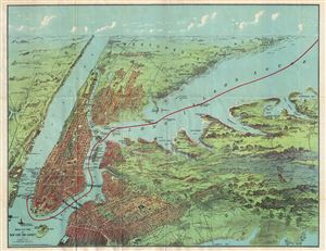
Birds Eye View of New York and Vicinity.
sold
- Digital Map Information
- Suitable for large format printing
- File Size: 16.83 MB
- File Type: ZIP / TIFF
- ICC color profile embedded
- Delivered instantly via download link
An exceptionally scarce 1912 chromolithograph C. S. Hammond and Company map and view of New York City and vicinity. The view extends from Ellis Island to Huntington Bay and from Yonkers to Jamaica Bay, covering thus all of Manhattan, Brooklyn, Queens, the Bronx, ... (more details)
Distributed by the Way's Auto Inn from Orlando.
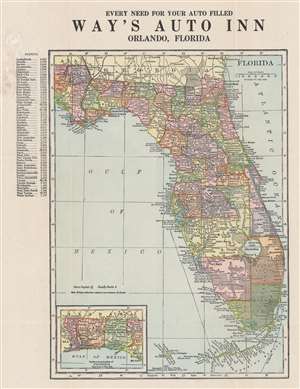
Florida.
sold
- Digital Map Information
- Suitable for large format printing
- Full resolution TIFF file
- ICC color profile embedded
- Delivered instantly via download link
This is a 1915 C. S. Hammond map of Florida, for distribution by Way's Auto Inn in Orlando. Major roads are illustrated and cities, towns, and villages throughout the state are labeled. An inset in the lower-left focuses on the Florida Panhandle from Alabama to West Bay. An index along the left presents the most recent population data for fifty-five Florida cities, given in alphabetical order. (more details)
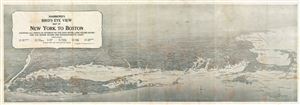
Hammond's Bird's Eye View map of New York to Boston Showign All Points of Interest on the East River, Long Island Sound and the Rhode Island and Massachusetts Coast.
sold
- Digital Map Information
- Suitable for large format printing
- File Size: 1.34 MB
- File Type: ZIP / TIFF
- ICC color profile embedded
- Delivered instantly via download link
This is a fine example of the C. S. Hammond's 1920 bird's eye view map of New York to Boston. Focusing mainly on Long Island, the map covers from Richmond (Staten Island) to Cape Cod. Includes Nantucket Island, Block Island and Martha's Vineyard. Various ... (more details)
Issued to promote the Murray Hill and Plaza Hotels of New York City.
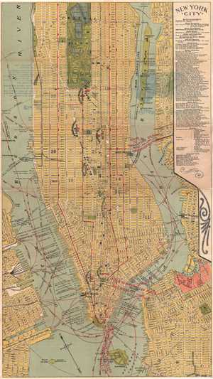
New York City.
sold
- Digital Map Information
- Suitable for large format printing
- File Size: 10.2 MB
- File Type: ZIP / TIFF
- ICC color profile embedded
- Delivered instantly via download link
This is a nice c.1920s map of New York City by F. A. Hammond. The map covers from the Battery and Governor’s Island north to 94th Street in extraordinary detail. Parts of Brooklyn, Queens and New Jersey are also featured. Roosevelt Island and Governor’s ... (more details)
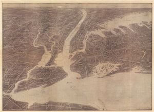
Hammond's Birds Eye View Map of New York City and Vicinity showing Roads, Railroads, Cities and Towns, etc.
sold
- Digital Map Information
- Suitable for large format printing
- Full resolution TIFF file
- ICC color profile embedded
- Delivered instantly via download link
This is an exceptionally scarce 1925 chromolithograph C. S. Hammond and Company map and view of New York City and vicinity. The view extends from Raritan Bay north to Croton Point and east as far as Huntington, covering all of Manhattan, Brooklyn, Queens, ... (more details)
Rare American World War II Propaganda Broadside - promotes American defense before Pearl Harbor!
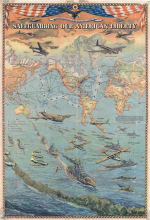
Safeguarding Our American Liberty.
sold
- Digital Map Information
- Suitable for large format printing
- File Size: 28.62 MB
- File Type: ZIP / TIFF
- ICC color profile embedded
- Delivered instantly via download link
This is a 1941 Lambert Guenther propaganda broadside map of the world extolling American defensive preparedness on the brink of World War II. This broadside was issued to promote the belief that, even as war raged across the globe, the United States was ... (more details)
Features a visually arresting border highlighting American air, land, and sea power to be used in the coming war.
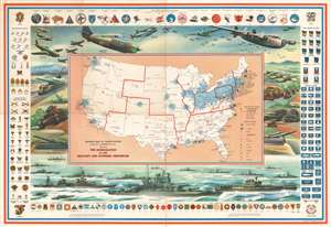
Defense Map of the United States Prepared by C.S. Hammond and Company, N.Y. Showing the Mobilization of our Military and Economic Resources.
sold
- Digital Map Information
- Suitable for large format printing
- File Size: 49.95 MB
- File Type: ZIP / TIFF
- ICC color profile embedded
- Delivered instantly via download link
This is a c. 1941 C. S. Hammond and Company pictorial map of the United States highlighting the military and economic resources available on the brink of World War II. The map depicts the United States from the Pacific coast to the Atlantic Seaboard and from the Canadian border to the Mexican border and Key West. Blu -colored cogs highlight industrial areas around the country in an effort to illustrate the industrial might that would be brought to bear. Other defense industries are marked on the map by icons, including shipyards and factories making planes, airplane engines, munitions, tanks, guns, steel, and aluminum. Army and navy bases are identified as well, as are army and navy airfields.
It is the pictorial border, however, that immediately draws the viewer's attention. The air, land, and sea forces of the United States military are put on full display, creating a forceful image that definitely falls under the umbrella of propaganda and the banner of 'support the military'. Cutting edge aircraft, such as the Boeing B-17 Flying Fortress, Consolidated B-24 Liberator, Lockheed P-38 Lightning, Grumman F4F Wildcat, and Curtiss P-40 Warhawk, are prominently illustrated along the map's top border, with tanks, artillery guns, howitzers, and supply trucks representing ground forces.
Perhaps the most incredible part of this piece (with the benefit of hindsight of course) is the placement of the battleship front and center along the bottom border. The legendary naval engagements fought between the United States and Japan had not yet occurred, and naval strategists believed that the battleship, not the aircraft carrier, would be the key element to success on the world's oceans. An aircraft carrier appears to the right of the battleship, complete with its aircraft on the flight deck. A heavy cruiser steams to the battleship's left, surrounded by torpedo boats, light cruisers, destroyers, and submarines.
Illustrations of American Army and Navy insignia frame the entire piece, with army insignia on the left and navy insignia on the right. Army insignia of rank, from general to private first class, are situated at the top left, while insignia of 'arms and services', such as the infantry, ordnance department, signal corps, and medical corps, are on the bottom left. Naval insignia of rank are just opposite, on the top right, while naval specialty marks, such as sharpshooter, bugler, machinist's mate, and cook, are on the bottom right. A sample of Army and Navy Air Corps insignia are included along the top, while the insignia of army headquarters, field armies, army corps, and army divisions are along the bottom. (more details)
It is the pictorial border, however, that immediately draws the viewer's attention. The air, land, and sea forces of the United States military are put on full display, creating a forceful image that definitely falls under the umbrella of propaganda and the banner of 'support the military'. Cutting edge aircraft, such as the Boeing B-17 Flying Fortress, Consolidated B-24 Liberator, Lockheed P-38 Lightning, Grumman F4F Wildcat, and Curtiss P-40 Warhawk, are prominently illustrated along the map's top border, with tanks, artillery guns, howitzers, and supply trucks representing ground forces.
Perhaps the most incredible part of this piece (with the benefit of hindsight of course) is the placement of the battleship front and center along the bottom border. The legendary naval engagements fought between the United States and Japan had not yet occurred, and naval strategists believed that the battleship, not the aircraft carrier, would be the key element to success on the world's oceans. An aircraft carrier appears to the right of the battleship, complete with its aircraft on the flight deck. A heavy cruiser steams to the battleship's left, surrounded by torpedo boats, light cruisers, destroyers, and submarines.
Illustrations of American Army and Navy insignia frame the entire piece, with army insignia on the left and navy insignia on the right. Army insignia of rank, from general to private first class, are situated at the top left, while insignia of 'arms and services', such as the infantry, ordnance department, signal corps, and medical corps, are on the bottom left. Naval insignia of rank are just opposite, on the top right, while naval specialty marks, such as sharpshooter, bugler, machinist's mate, and cook, are on the bottom right. A sample of Army and Navy Air Corps insignia are included along the top, while the insignia of army headquarters, field armies, army corps, and army divisions are along the bottom. (more details)
Detailed map of the city of Los Angeles.
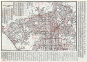
Map of Los Angeles California.
sold
- Digital Map Information
- Suitable for large format printing
- File Size: 37.85 MB
- File Type: ZIP / TIFF
- ICC color profile embedded
- Delivered instantly via download link
This is a large 1941 pocket map of Los Angeles, California by E. F. Hill, issued by C.S. Hammond and Company. It extends from Griffith Park south to Inglewood and South Gate. The map is incredibly detailed and notes individual streets, boulevards, ... (more details)