
Ogilby, John (sold)
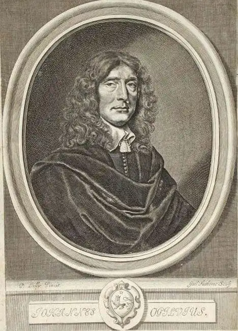
John Ogilby (November 17, 1600 - 1676) was a Scottish translator and cartographer. John Ogilby's life seems to be one of extremes, teetering between wealth and poverty, success and failure. Ogilby was born near Edinburgh, Scotland, into a once wealthy family laid low by extreme debt. Struggling with poverty at every turn, Ogilby involved himself in various businesses ranging from dancing master, to actor, to tutor. In 1612, at age 12, Ogilby won a lottery run to advance the colonial interests of Virginia. His winning were sufficient to pay of many of his father's debts and apprentice himself to a dancing master. Ogilby proved a natural and graceful dancer and even made extra money tutoring his fellow apprentices. Starcrossed as he was, Olgiby's dancing career ended when a misstep when a misstep at a masked ball injured his leg and left him lame for live. Afterwards he managed to leverage his contacts in the dance world to secure a position as a dance instructor to the daughters of Sir Ralph Hopton. Hopton struck an immediate friendship with Olgiby and trained him in Military Science. Later Ogilby relocated to Ireland where he worked an as actor and later as Master of Revels. The Irish Rebellion of 1641 again dashed Ogilby's fortunes and forced him to flee Dublin by ship. On the way, the ship sunk but the survivors were rescued and eventually made their way to England, which was then under the strict rule of Oliver Cromwell. Ogilby took refuge at Cambridge where he mastered Greek and Latin. Following the Restoration of Charles II, Ogilby invested in his first major literary venture, a translation of Virgil into English. This work earned him the patronage of Charles II, despite the ridicule of prominent poets Dryden and Pope. Under Royal patronage Ogilby published several volumes relating to the Restoration. In short order he has established a successful London publisher based out of the Whitefriars district. This, unfortunately turned out to be a fateful choice of location as in 1666 the Great Fire of London tore through this are destroying Ogilby's publishing stock, home, and business. Once again Ogilby exhibited a remarkable phoenix-like ability to literally rise from the ashes. Shortly after the Great Fire, he began his most important ventures as a publisher of geographical works. In order to recover from the fire, Ogilby and his grandson were took positions as surveyors commissioned to create a large property map of London. The resultant map of London, "London Survey'd", was published in 1677 and earned Ogilby the honorific "Kings Cosmographer and Geographic Printer". His most famous works are his 1675 Road Atlas of England, Britannia which redefined road mapping, and his 1671 Atlas of the Americas.
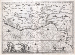
Guinea. (Gvinea.)
sold
- Digital Map Information
- Suitable for large format printing
- Full resolution TIFF file
- ICC color profile embedded
- Delivered instantly via download link
This is an extraordinary 1670 map of West Africa by English cartographer John Ogilby. Depicts the African Gold Coast, Ivory Coast, and Slave Coast from Guniea south through the modern nations of, Sierra Leone, Liberia, Mali, Burkina Faso, Cote D'Ivoire, Ghana, ... (more details)
The first map in the Visscher-Jansson Series to identify New York, New Jersey, and Albany.
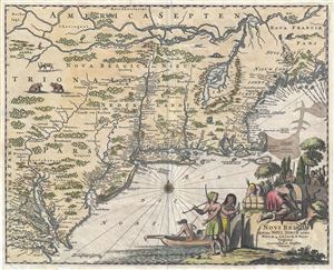
Novi Belgii quod nunc Novi Jorck vocatur, Novae Qe. Angliae & Partis Virginiae Accuratissima et Novissima Delineatio.
sold
- Digital Map Information
- Suitable for large format printing
- DPI: 300
- File Size: 6.84 MB
- File Type: ZIP / TIFF
- ICC color profile embedded
- Delivered instantly via download link
A very attractive example of Arnoldus Montanus and John Ogilby's 1671 important map of New York, Virginia, New Jersey, and New England - the first in the Jansson-Visscher series to use British nomenclature. Part of the Jansson-Visscher Series (maps derived ... (more details)
One of the earliest obtainable views of New York City or, as it was, New Amsterdam.
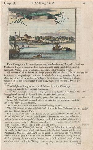
Novum Amsterodamum.
sold
- Digital Map Information
- Suitable for large format printing
- DPI: 300
- File Size: 3.71 MB
- File Type: ZIP / TIFF
- ICC color profile embedded
- Delivered instantly via download link
A fine example of John Ogilby's 1671 view of New Amsterdam, one of the earliest obtainable depictions of New York City. Prepared for Ogilby's America , this vies is mostly likely based on a very similar watercolor completed by Laurens Hermansz Block in 1650 ... (more details)
Beautiful bird's eye-view of Acapulco Mexico.
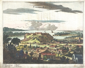
Portus Acapulco.
sold
- Digital Map Information
- Suitable for large format printing
- DPI: 300
- File Size: 5.48 MB
- File Type: ZIP / TIFF
- ICC color profile embedded
- Delivered instantly via download link
A rare 1671 view of the port of Acapulco, Mexico, by Englishman John Ogilby. This impressive view embraces the heart of colonial Acapulco, showing the Fort of San Diego and the surrounding port community. In the foreground mounted Spaniards lead ... (more details)
One of the first renderings of the Carolina colony's interior.
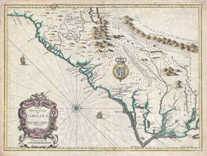
A New Description of Carolina.
sold
- Digital Map Information
- Suitable for large format printing
- Full resolution TIFF file
- ICC color profile embedded
- Delivered instantly via download link
A beautiful example of John Speed's important 1676 map of the Carolina colony. Heavily based upon the explorations of John Lederer and Ogilby's Lords Proprietor's Map of 1674. This seminal map represents one of the earliest attempts to map the ... (more details)
A ground-breaking map of Carolina showing the contentions geography of Jonathan Lederer.
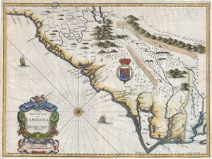
A New Description of Carolina.
sold
- Digital Map Information
- Suitable for large format printing
- Full resolution TIFF file
- ICC color profile embedded
- Delivered instantly via download link
A very attractive example of John Speed's important and rare 1676 map of the Carolina colony - representing the first serious attempts to map the interior of the Carolinas based upon actual exploration. Speed heavily based his cartography of Carolina upon the explorations of John Lederer and Ogilby's Lords Proprietor's Map of 1674. Oriented to the West, map covers from the Spanish colony of St. Augustine, Florida, north to the English colony of Jamestown, Virginia. It extends inland as far as the Appalachian (Apalathean) Mountains. (more details)
Essential Map for the Carolina Collector.
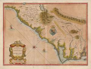
A New Description of Carolina.
sold
- Digital Map Information
- Suitable for large format printing
- Full resolution TIFF file
- ICC color profile embedded
- Delivered instantly via download link
A striking example of the important and scarce map of the Carolina colony engraved by Francis Lamb in 1676, for inclusion in John Speed's atlas. It is one of the earliest early English maps specifically of the colony acquirable by the collector, published just six years after the founding of Charleston. As such, it is a map of seminal importance, and an essential document in the history of the Carolinas specifically, and the British settlements in North America in general. (more details)
First Map of Maryland - Promoting colonization.
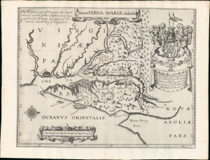
Nova Terrae-Mariae Tabula.
sold
- Digital Map Information
- Suitable for large format printing
- Full resolution TIFF file
- ICC color profile embedded
- Delivered instantly via download link
This is the 1671 John Ogilby second edition of the 1635 Lord Baltimore map of the Chesapeake Bay - considered the first map of Maryland. Although based on the 1635 map, this Ogilby edition is no slavish copy and includes unique and significant cartography not found elsewhere. It was issued to promote British colonization of Maryland and includes a wealth of unique, relevant detail, including new town sites, ten new county designations, and more defined borders. By all reports, it was successful, with nearly 25,000 English settlers moving to Maryland by 1681. (more details)
London to Marlborough by Foot or Horse.
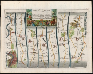
The Road from London to the City of Bristol...
sold
- Digital Map Information
- Suitable for large format printing
- DPI: 600
- File Size: 40.54 MB
- File Type: ZIP / TIFF
- ICC color profile embedded
- Delivered instantly via download link
This is John Ogilby's road map detailing the first leg of the road between the cities of London and Bristol. It is a strip-map, following the London Road and the Bath Road from London eastwards to Marlborough in seven lengths, presented as if on a single, unspooled scroll. The road passes through Hammersmith, Harlington and Harmondsworth, Colnbrook Maidenhead, Reading, Woolhampton, Thatcham, Newbury, Chilton, Ramesbury, and Marlborough. Smaller towns, bridges, forests, churches, manors, and county borders are all noted along the way. Parks, Greens, and even some ruins (for example Donnington Castle near Newbury) are marked as well. (more details)
Oxford to Bristol by Foot or Horse.
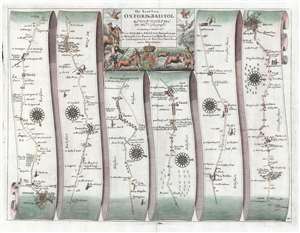
The Road from Oxford to Bristol by John Ogilby Esqr.
sold
- Digital Map Information
- Suitable for large format printing
- Full resolution TIFF file
- ICC color profile embedded
- Delivered instantly via download link
This is John Ogilby's road map detailing the road between the cities of Oxford and Bristol. It is a strip-map, following the road from Oxford south and west in six lengths, presented as if on a single, unspooled sheet of paper. Smaller towns, bridges, forests, churches, and county borders are all noted along the way. Pastures, and even some coal mines are marked as well. Strip maps served to inform travelers of the distances, landmarks, obstacles and resting points along a given road between two destinations. Changes in direction along the way are indicated by the placement of attractive compass-roses. The wise traveler, of course, would never leave the high road; consequently, no further routes would require consideration.
The map's attractive cartouche is embellished with what appears to be a remarkably unsuccessful hunting scene: the mounted hunter, his footmen, and his dogs unable to snare any of the fowl taking wing.
Britannia was based on firsthand survey by Ogilby and his team, who published their results at a uniform scale of one inch to one mile. Of more general importance, Ogilby standardized the English mile throughout his book at 1,760 yards (prior to this, no such uniformity existed in England.) Ogilby's work was the first to utilize strip maps of this kind, but the 18th century would see similar works published by Bowen, Gardner and Senex. (more details)
The map's attractive cartouche is embellished with what appears to be a remarkably unsuccessful hunting scene: the mounted hunter, his footmen, and his dogs unable to snare any of the fowl taking wing.
Britannia was based on firsthand survey by Ogilby and his team, who published their results at a uniform scale of one inch to one mile. Of more general importance, Ogilby standardized the English mile throughout his book at 1,760 yards (prior to this, no such uniformity existed in England.) Ogilby's work was the first to utilize strip maps of this kind, but the 18th century would see similar works published by Bowen, Gardner and Senex. (more details)