
Petersen, C. C. (sold)

C. C. Petersen (fl. c. 1940 – 1950) was an advertising and publishing company based in Toronto Canada, but with distribution and licensing in both the United States and Canada. Petersen had contracts with the artist Stanley Francis Turner to publish pictorial 'war maps' during World War II. The company supplemented its income by selling advertisements on Turner's maps.
Only the second edition of the iconic series of Dated War Maps created by Turner during the Second World War.
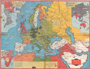
Dated Events World War Map.
sold
- Digital Map Information
- Suitable for large format printing
- File Size: 17.47 MB
- File Type: ZIP / TIFF
- ICC color profile embedded
- Delivered instantly via download link
This is a 1941 Stanley Francis Turner map of Europe during World War II. The map depicts the continent from the Atlantic Ocean to Afghanistan and from the Arctic Ocean to northern Africa. As with all of Turner's dated war maps, the Axis and the Allies are ... (more details)
Stanley Turner's first World War II 'Dated Events' map.
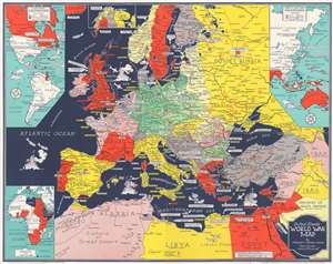
Dated Events World War Map.
sold
- Digital Map Information
- Suitable for large format printing
- File Size: 23.82 MB
- File Type: ZIP / TIFF
- ICC color profile embedded
- Delivered instantly via download link
This is a 1941 Stanley Francis Turner map of Europe during World War II (1939 - 1945), likely Turner's first 'Dated Events' map. This map was issued in late May or early June, based on the events noted. Text boxes mark events, including combat actions and declarations of war, beginning with the 1938 Anschluss. Icons illustrate areas rich in resources, including steel, wheat, coal, and iron - valuable to the war effort on both sides. France is divided into the Occupied Zone and the Unoccupied Zone. (more details)
Scarce highly detailed world and pacific theater map during World War II, 1943.
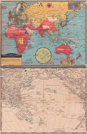
Map of the World War Fronts: Dated Events.
sold
- Digital Map Information
- Suitable for large format printing
- File Size: 20.96 MB
- File Type: ZIP / TIFF
- ICC color profile embedded
- Delivered instantly via download link
This is a double sided, highly detailed, and extremely rare 1943 Stanley Francis Turner pictorial map of the situation of World War II as of mid-1943. On the recto, a full color map of the Eastern Hemisphere is depicted, stretching from the British Isles ... (more details)
America's WWII rearmament.
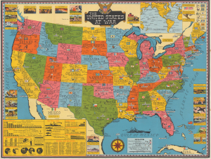
The United States at War.
sold
- Digital Map Information
- Suitable for large format printing
- Full resolution TIFF file
- ICC color profile embedded
- Delivered instantly via download link
This is a 1943 Stanley Francis Turner map of the United States during World War II (1939 - 1945). This map emphasizes the burgeoning industrial strength of the United States and its effect on the Allied war effort. (more details)
Likely published within days of the D-Day landings in Normandy, France.
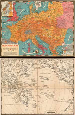
Dated Events Invasion Map of Fortress Europe. Seventh Edition.
sold
- Digital Map Information
- Suitable for large format printing
- File Size: 57.71 MB
- File Type: ZIP / TIFF
- ICC color profile embedded
- Delivered instantly via download link
This is a 1944 Stanley Francis Turner pictorial map of Europe just after the D-Day invasion of France. This is the first edition of Turner's 'Dated Events War Map' series to depict the D-Day invasions, published only days after the landings in France. (more details)
Likely published within days of the D-Day landings in Normandy, France.
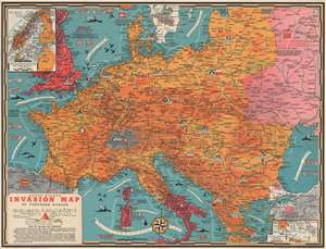
Dated Events Invasion Map of Fortress Europe. Seventh Edition.
sold
- Digital Map Information
- Suitable for large format printing
- Full resolution TIFF file
- ICC color profile embedded
- Delivered instantly via download link
This is a 1944 Stanley Francis Turner pictorial map of Europe just after the D-Day invasion of France. This is the first edition of Turner's 'Dated Events War Map' series to depict the D-Day invasions, published only days after the landings in France. (more details)
Likely published within days of the D-Day landings in Normandy, France.
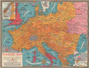
Dated Events Invasion Map of Fortress Europe. Seventh Edition.
sold
- Digital Map Information
- Suitable for large format printing
- Full resolution TIFF file
- ICC color profile embedded
- Delivered instantly via download link
This is a 1944 Stanley Francis Turner pictorial map of Europe just after the D-Day invasion of France. This is the first edition of Turner's 'Dated Events War Map' series to depict the D-Day invasions, published only days after the landings in France. (more details)
Published just days after D-Day.
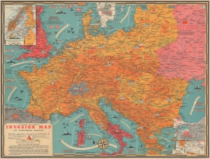
Dated Events Invasion Map of Fortress Europe. Seventh Edition.
sold
- Digital Map Information
- Suitable for large format printing
- Full resolution TIFF file
- ICC color profile embedded
- Delivered instantly via download link
This is a 1944 Stanley Francis Turner pictorial map of Europe just after the D-Day invasion of France. This is the first edition of Turner's 'Dated Events War Map' series to depict the D-Day invasions, published only days after the landings in France. (more details)
Includes an inset map commemorating the D-Day invasion of Fortress Europe - June 6, 1944!
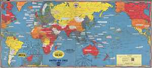
Dated Events War Map. Invasion Map of Fortress Europe. Commemorating D-Day June 6, 1944.
sold
- Digital Map Information
- Suitable for large format printing
- File Size: 14.59 MB
- File Type: ZIP / TIFF
- ICC color profile embedded
- Delivered instantly via download link
This is a 1944 Stanley Francis Turner world map detailing the events of World War II until mid-1944 specifically commemorating the Normandy landings on June 6, 1944. The map depicts the world from the Atlantic coast of North America and the whole of ... (more details)
Celebrates the end of World War II in both Europe and the Pacific - includes photos of the flag raising on Iwo Jima and the atomic bomb.
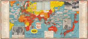
Dated Events War Map.
sold
- Digital Map Information
- Suitable for large format printing
- File Size: 36.65 MB
- File Type: ZIP / TIFF
- ICC color profile embedded
- Delivered instantly via download link
This is a 1945 Stanley Francis Turner map of the world at the end of World War II. The map depicts the world from St. John's in Newfoundland, Canada to Salt Lake City, Utah and from the Barents Sea and the Arctic Ocean to Macquarie Island in the southwest Pacific Ocean. Myriad events throughout the European, North African, and Pacific Theaters of War are identified, including numerous declarations of war, the Japanese attack on Pearl Harbor, the D-Day Invasion of France, the liberation of Rome and Paris, and nearly all the amphibious landings in the Pacific island-hopping campaign. Rommel's retreat from Egypt through Libya into Tunisia is noted by a white line, while solid white lines in Europe, Africa, and the Pacific illustrate the greatest extent of Axis gains.
Two large flags, just below center, commemorate and celebrate V-E (Victory in Europe) Day, May 8, 1945, and V-J (Victory over Japan) Day, September 2, 1945. Events in the European Theater are chronicled along the map's left border, from the Munich Agreement on September 30, 1938 to Clement Attlee's inauguration as Prime Minister, replacing Winston Churchill. Events during the Pacific War are listed along the right border, from the beginning of the Shanghai Incident between China and Japan in January 1932 to V-J Day. A 'box score of the Pacific War', situated along the bottom border, lists the number of ships lost by both the Japanese and the U.S. during the course of the war, along with the comparative losses of the number of airplanes. A large inset map of Japan is located in the lower right corner, while photographs of the Pearl Harbor attack and one of the mushroom clouds from the atomic bombs dropped on Japan occupy the upper right corner. Photographs of General Eisenhower and General MacArthur are included in the lower left corner. (more details)
Two large flags, just below center, commemorate and celebrate V-E (Victory in Europe) Day, May 8, 1945, and V-J (Victory over Japan) Day, September 2, 1945. Events in the European Theater are chronicled along the map's left border, from the Munich Agreement on September 30, 1938 to Clement Attlee's inauguration as Prime Minister, replacing Winston Churchill. Events during the Pacific War are listed along the right border, from the beginning of the Shanghai Incident between China and Japan in January 1932 to V-J Day. A 'box score of the Pacific War', situated along the bottom border, lists the number of ships lost by both the Japanese and the U.S. during the course of the war, along with the comparative losses of the number of airplanes. A large inset map of Japan is located in the lower right corner, while photographs of the Pearl Harbor attack and one of the mushroom clouds from the atomic bombs dropped on Japan occupy the upper right corner. Photographs of General Eisenhower and General MacArthur are included in the lower left corner. (more details)
The end of World War II - photos of the flag raising on Iwo Jima and the atomic bomb.
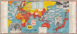
Dated Events War Map.
sold
- Digital Map Information
- Suitable for large format printing
- File Size: 40.5 MB
- File Type: ZIP / TIFF
- ICC color profile embedded
- Delivered instantly via download link
This is a 1945 Stanley Francis Turner map of the world at the end of World War II. The map depicts the world from St. John's in Newfoundland, Canada to Salt Lake City, Utah and from the Barents Sea and the Arctic Ocean to Macquarie Island in the southwest Pacific Ocean. Myriad events throughout the European, North African, and Pacific Theaters of War are identified, including numerous declarations of war, the Japanese attack on Pearl Harbor, the D-Day Invasion of France, the liberation of Rome and Paris, and nearly all the amphibious landings in the Pacific island-hopping campaign. Rommel's retreat from Egypt through Libya into Tunisia is noted by a white line, while solid white lines in Europe, Africa, and the Pacific illustrate the greatest extent of Axis gains.
Two large flags, just below center, commemorate and celebrate V-E (Victory in Europe) Day, May 8, 1945, and V-J (Victory over Japan) Day, September 2, 1945. Events in the European Theater are chronicled along the map's left border, from the Munich Agreement on September 30, 1938 to Clement Attlee's inauguration as Prime Minister, replacing Winston Churchill. Events during the Pacific War are listed along the right border, from the beginning of the Shanghai Incident between China and Japan in January 1932 to V-J Day. A 'box score of the Pacific War', situated along the bottom border, lists the number of ships lost by both the Japanese and the U.S. during the course of the war, along with the comparative losses of the number of airplanes. A large inset map of Japan is located in the lower right corner, while photographs of the Pearl Harbor attack and one of the mushroom clouds from the atomic bombs dropped on Japan occupy the upper right corner. Photographs of General Eisenhower and General MacArthur are included in the lower left corner. (more details)
Two large flags, just below center, commemorate and celebrate V-E (Victory in Europe) Day, May 8, 1945, and V-J (Victory over Japan) Day, September 2, 1945. Events in the European Theater are chronicled along the map's left border, from the Munich Agreement on September 30, 1938 to Clement Attlee's inauguration as Prime Minister, replacing Winston Churchill. Events during the Pacific War are listed along the right border, from the beginning of the Shanghai Incident between China and Japan in January 1932 to V-J Day. A 'box score of the Pacific War', situated along the bottom border, lists the number of ships lost by both the Japanese and the U.S. during the course of the war, along with the comparative losses of the number of airplanes. A large inset map of Japan is located in the lower right corner, while photographs of the Pearl Harbor attack and one of the mushroom clouds from the atomic bombs dropped on Japan occupy the upper right corner. Photographs of General Eisenhower and General MacArthur are included in the lower left corner. (more details)
The end of World War II - photos of the flag raising on Iwo Jima and the atomic bomb.
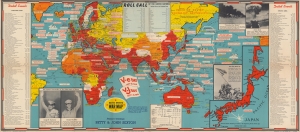
Dated Events War Map.
sold
- Digital Map Information
- Suitable for large format printing
- File Size: 91.87 MB
- File Type: ZIP / TIFF
- ICC color profile embedded
- Delivered instantly via download link
This is a 1945 Stanley Francis Turner map of the world at the end of World War II. The map depicts the world from St. John's in Newfoundland, Canada to Salt Lake City, Utah and from the Barents Sea and the Arctic Ocean to Macquarie Island in the southwest Pacific Ocean. Myriad events throughout the European, North African, and Pacific Theaters of War are identified, including numerous declarations of war, the Japanese attack on Pearl Harbor, the D-Day Invasion of France, the liberation of Rome and Paris, and nearly all the amphibious landings in the Pacific island-hopping campaign. Rommel's retreat from Egypt through Libya into Tunisia is noted by a white line, while solid white lines in Europe, Africa, and the Pacific illustrate the greatest extent of Axis gains. (more details)
Celebrates the end of World War II in both Europe and the Pacific - includes photos of the flag raising on Iwo Jima and the atomic bomb.
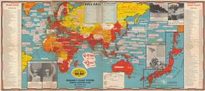
Dated Events War Map.
sold
- Digital Map Information
- Suitable for large format printing
- File Size: 44.12 MB
- File Type: ZIP / TIFF
- ICC color profile embedded
- Delivered instantly via download link
This is a 1945 Stanley Francis Turner map of the world at the end of World War II. The map depicts the world from St. John's in Newfoundland, Canada to Salt Lake City, Utah and from the Barents Sea and the Arctic Ocean to Macquarie Island in the southwest Pacific Ocean. Myriad events throughout the European, North African, and Pacific Theaters of War are identified, including numerous declarations of war, the Japanese attack on Pearl Harbor, the D-Day Invasion of France, the liberation of Rome and Paris, and nearly all the amphibious landings in the Pacific island-hopping campaign. Rommel's retreat from Egypt through Libya into Tunisia is noted by a white line, while solid white lines in Europe, Africa, and the Pacific illustrate the greatest extent of Axis gains.
Two large flags, just below center, commemorate and celebrate V-E (Victory in Europe) Day, May 8, 1945, and V-J (Victory over Japan) Day, September 2, 1945. Events in the European Theater are chronicled along the map's left border, from the Munich Agreement on September 30, 1938 to Clement Attlee's inauguration as Prime Minister, replacing Winston Churchill. Events during the Pacific War are listed along the right border, from the beginning of the Shanghai Incident between China and Japan in January 1932 to V-J Day. A 'box score of the Pacific War', situated along the bottom border, lists the number of ships lost by both the Japanese and the U.S. during the course of the war, along with the comparative losses of the number of airplanes. A large inset map of Japan is located in the lower right corner, while photographs of the Pearl Harbor attack and one of the mushroom clouds from the atomic bombs dropped on Japan occupy the upper right corner. Photographs of General Eisenhower and General MacArthur are included in the lower left corner. (more details)
Two large flags, just below center, commemorate and celebrate V-E (Victory in Europe) Day, May 8, 1945, and V-J (Victory over Japan) Day, September 2, 1945. Events in the European Theater are chronicled along the map's left border, from the Munich Agreement on September 30, 1938 to Clement Attlee's inauguration as Prime Minister, replacing Winston Churchill. Events during the Pacific War are listed along the right border, from the beginning of the Shanghai Incident between China and Japan in January 1932 to V-J Day. A 'box score of the Pacific War', situated along the bottom border, lists the number of ships lost by both the Japanese and the U.S. during the course of the war, along with the comparative losses of the number of airplanes. A large inset map of Japan is located in the lower right corner, while photographs of the Pearl Harbor attack and one of the mushroom clouds from the atomic bombs dropped on Japan occupy the upper right corner. Photographs of General Eisenhower and General MacArthur are included in the lower left corner. (more details)
Includes eleven photographs provided by the Canadian Pacific Railway.
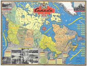
Canada.
sold
- Digital Map Information
- Suitable for large format printing
- File Size: 19.52 MB
- File Type: ZIP / TIFF
- ICC color profile embedded
- Delivered instantly via download link
This is a 1945 Stanley Francis Turner pictorial map of postwar Canada. The map depicts the region from the Pacific Ocean to the Greenland and the Atlantic Ocean and from the Arctic Ocean and Baffin Bay to the United States. Highly detailed, numerous ... (more details)
World events from the late 1930s to the founding of Israel.
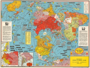
Dated Events Map The World To Day with Latest Boundaries.
sold
- Digital Map Information
- Suitable for large format printing
- File Size: 43.3 MB
- File Type: ZIP / TIFF
- ICC color profile embedded
- Delivered instantly via download link
This is a 1948 Stanley Francis Turner map of the world on a polar projection. Completed in Turner's iconic style, the countries of the world are all labeled and many of these countries' flags are illustrated as well. World capitals are highlighted in yellow and myriad other cities throughout the world are also labeled. Africa's geography still represents the era of colonialism, with French Equatorial Africa, French West Africa, the Belgian Congo, Rhodesia, and Tanganyika all labeled. Icons mark natural resources, including oil, coal, iron, steel, and gold, along with corn, wool, lumber, and rubber. Small mushroom clouds mark 'sources of uranium'. Insets in the lower left corner detail central and eastern Europe (including the Allied occupation of Germany), the suggested partition of Palestine (with yellow shaded areas marking proposed Jewish regions), and southern South America (which was cut off by the map's projection). (more details)