
White, Ruth D. Taylor (sold)
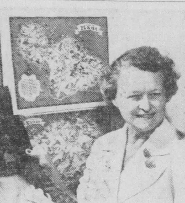
Ruth D. Taylor White (March 1896 - 20??), a.k.a. Ruth Taylor Day, was an American pictorial mapmaker, what she liked to call 'carto-graphy'. Ruth was born Oregon to the painter John S. Taylor (1858 - 1927). Her interest in cartographic mapmaking was probably inspired by her sister Della Taylor Hoss (1900 - 1997), also an important pictorial cartographer. One of her first published works was a cover of The Stanford Illustrated Review, where her brother Frank attended university. Frank was an accomplished journalist and writer, and Ruth provided the illustrations for two of his books, popular works about the national parks, ’Oh Ranger!’ A Book About the National Parks and Grand Canyon Country. In the spring of 1930, White traveled to Hawaii, where she received a commission from the Hawaii Tourist Bureau to create pictorial maps of the Hawaiian Islands. Sets of five maps began appearing in 1931, with maps of Kauai, Oahu, Maui, Hawaii, and the island chain as part of the set. These were most likely handed out to visitors by the Bureau. White’s most famous work, a pictorial atlas entitled, Our USA: A Gay Geography was published in 1935 and was filled with ‘cartography’ of each state, which she published with her brother as Ruth Taylor. White is also known for her map of Treasure Island, the site of the Golden Gate International Exposition. A third sister, Bernice Taylor Fitzgerald, was also an artist, but did not make maps. Ruth was still an active artist as late as 1997. There is no record of her death, suggesting she may well be a centenarian.
A 'treasure island'!
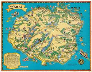
Island of Kauai.
sold
- Digital Map Information
- Suitable for large format printing
- File Size: 54.47 MB
- File Type: ZIP / TIFF
- ICC color profile embedded
- Delivered instantly via download link
This is a 1931 Ruth Taylor White pictorial map of Kauai, Hawaii, commissioned by the Hawaii Tourist Bureau. Kauai appears as a tropical paradise with travelers arriving by ocean liner, sunbathing, swimming, and exploring the interior. Wild pigs and goats roam the island. Waimea Canyon and Olokele Canyon catch the eye, along with Mt. Waialeale (the wettest place on Earth). A tourist peers into the sky atop the mountain in a yellow raincoat and hat under an umbrella. The world famous Napali Coast is situated on the left side of the island. The site of Captain Cook's 1788 landing is identified as well. (more details)
Pictorial map of the island of Hawaii.
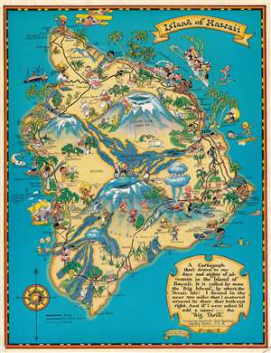
Island of Hawaii.
sold
- Digital Map Information
- Suitable for large format printing
- File Size: 55.47 MB
- File Type: ZIP / TIFF
- ICC color profile embedded
- Delivered instantly via download link
This is a scarce 1931 Ruth Taylor White pictorial map of the island of Hawaii, commissioned by the Hawaii Tourist Bureau. The volcanoes Mauna Kea, Mauna Loa, and Kilauea dominate the island, with Kilauea is illustrated in mid-eruption. Dated lava flows are illustrated alongside lava tubes, and other formations. White blends Hawaii's tourist appeal with history and indigenous culture, noting the birthplace of Kamehameha I, the arrival of Captain Cook, and Captain Cook's monument. (more details)
The best of Maui.
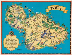
Island of Maui.
sold
- Digital Map Information
- Suitable for large format printing
- File Size: 46.7 MB
- File Type: ZIP / TIFF
- ICC color profile embedded
- Delivered instantly via download link
This is a 1931 Ruth Taylor White pictorial map of Maui, Hawaii, commissioned by the Hawaii Tourist Bureau. Tourists and Hawaiians intermingle, with golfers and sightseers appearing next to fishermen and other locals. Haleakala National Park and Haleakala Crater appear along with the 'old lava flows' below and to the left. Pineapples and sugarcane plantations dot the island. (more details)
Entertaining pictorial map of the Hawaiian Islands!
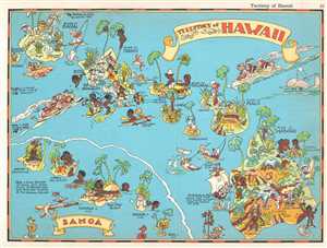
Territory of Hawaii. / Samoa.
sold
- Digital Map Information
- Suitable for large format printing
- File Size: 2.71 MB
- File Type: ZIP / TIFF
- ICC color profile embedded
- Delivered instantly via download link
This is a 1935 Ruth Taylor White pictorial map or 'cartograph' of the Hawaiian Islands and Samoa. The map depicts the Hawaiian Islands of Hawaii, Maui, Molokai, Kahoolawe, Lanai, Oahu, Kauai, and part of Niihau. Four islands in the Samoa are depicted, including ... (more details)
An entertaining pictorial map of the Philippines.
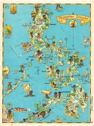
Philippine Islands.
sold
- Digital Map Information
- Suitable for large format printing
- File Size: 6.55 MB
- File Type: ZIP / TIFF
- ICC color profile embedded
- Delivered instantly via download link
This is a 1935 Ruth Taylor White pictorial map or 'cartograph' of the Philippines. The map depicts the archipelago from the South China. Sea to the Pacific Ocean and from Luzon to the Celebes Sea and Borneo. This 'cartograph' epitomizes the style and aesthetic of Ruth Taylor White, in that it is not meant to be geographically accurate but to entertain. In the 1930s, Manila was known as 'The Pearl of the Orient' and was an incredibly popular tourist destination. Here, White depicts a steamer full of tourists heading into Manila Bay right alongside and American battleship, complete with oversize guns. Native Filipinos, most of whom are barely clothed, are illustrated going about their lives beside white tourists frolicking in the ocean and reading in the sun. Many of the islands in the archipelago are labeled, and resources, such as copper, sulfur, gold, rubber, timber, and tobacco, are referenced. White also uses stereotypical caricatures of regional neighbors to globally situate the Philippines, including using a kangaroo and its joey to indicate the direction to Australia. (more details)
'Pageant' on the Eve of the WWII.
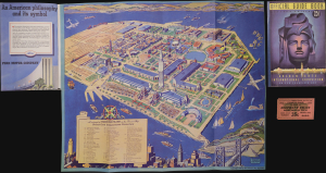
A Cartograph of Treasure Island in San Francisco Bay Golden Gate International Exposition.
sold
This is Ruth Taylor's colorful 1939 pictorial view of Treasure Island in San Francisco Bay, site of the 1939-1940 Golden Gate International Exposition. An extravaganza of Art Deco glamour and a celebration of diverse cultures, the Exposition nevertheless signaled an ephemeral era of optimistic cosmopolitanism before the global descent into World War II (1939-1945). (more details)
California's greatest and most accessible scenic playground!
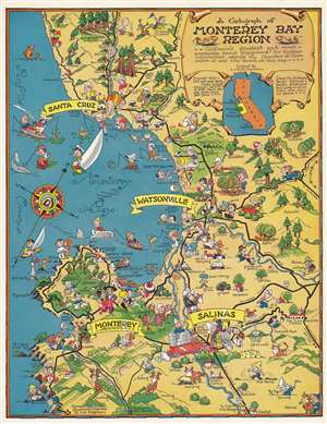
A cartograph of Monterey Bay region.
sold
- Digital Map Information
- Suitable for large format printing
- Full resolution TIFF file
- ICC color profile embedded
- Delivered instantly via download link
This is a c. 1950 pictorial map or 'cartograph' by Ruth Taylor depicting the Monterey Bay and surrounding communities along the California central coast. The richness and variety of the region's economy and culture are illustrated, ranging from maritime activities to golfing, hunting, and rodeos. (more details)