
Yasutarō Satō (sold)

Satō Yasutarō (佐藤裕太郎; March 5, 1893 – March 7, 1977), or Satō Yūtarō, was a Japanese educator active in Tokyo during the Taisho and Showa Eras. During and just prior to World War II, he worked with the Japanese Youth Club (少年俱樂部), a popular magazine which published several important manga maps of East Asia. After the war, Yasutarō became a professor at Tokyo University of Education and later, the the Senshu University.
'Kawaii' military expansionism.
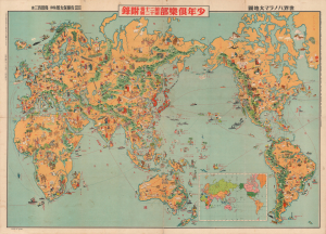
世界パノラマ大地圖 / World Panorama Map.
sold
- Digital Map Information
- Suitable for large format printing
- File Size: 194.97 MB
- File Type: ZIP / TIFF
- ICC color profile embedded
- Delivered instantly via download link
A remarkable 1933 Japanese issue pictorial map of the world drawn by Keizo Shimada (島田啓三). The map's cartoonish (manga) content seems deceptively innocent when this map is, ultimately, a propaganda piece underscoring nationalistic Japanese militarism in the lead up to the Second Sino-Japanese War (1937 - 1945) and World War II (1939 - 1945). (more details)
A uniquely Japanese combination of 'Kawaii' and military expansionism.
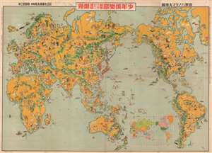
世界パノラマ大地圖 / World Panorama Daichi Sakai.
sold
- Digital Map Information
- Suitable for large format printing
- File Size: 78.97 MB
- File Type: ZIP / TIFF
- ICC color profile embedded
- Delivered instantly via download link
A remarkable 1933 Japanese issue pictorial map of the world drawn by Keizo Shimada (島田啓三). Centered on the Japanese Empire, which is highlighted in Red and includes both Taiwan and Korea, this map extends to cover the world with the exception of the Atlantic, which is only minimally addressed. The map presents a delightful array of vignettes intended to illustrate regional culture, flora, and fauna. Some of the images, despite being unbearably 'kawaii' are decidedly not politically correct, such as the rather intimidating looking Indian Chief in the Rocky Mountains. Despite the map's playful nature, Japan had already begun its grab for power in East Asia and the military aspect of the map is clear. Japanese destroyers patrol the western Pacific just as American destroyers stand watch on the Pacific Coast and in Hawaii. War was coming. (more details)
A uniquely Japanese combination of 'Kawaii' and military expansionism.
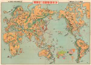
世界パノラマ大地圖 / World Panorama Daichi Sakai.
sold
- Digital Map Information
- Suitable for large format printing
- File Size: 56.87 MB
- File Type: ZIP / TIFF
- ICC color profile embedded
- Delivered instantly via download link
A remarkable 1933 Japanese issue pictorial map of the world drawn by Keizo Shimada (島田啓三). Centered on the Japanese Empire, which is highlighted in Red and includes both Taiwan and Korea, this map extends to cover the world with the exception of the Atlantic, which is only minimally addressed. The map presents a delightful array of vignettes intended to illustrate regional culture, flora, and fauna. Some of the images, despite being unbearably 'kawaii' are decidedly not politically correct, such as the rather intimidating looking Indian Chief in the Rocky Mountains. Despite the map's playful nature, Japan had already begun its grab for power in East Asia and the military aspect of the map is clear. Japanese destroyers patrol the western Pacific just as American destroyers stand watch on the Pacific Coast and in Hawaii. War was coming. (more details)
A uniquely Japanese combination of 'Kawaii' and military expansionism.
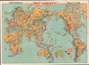
世界パノラマ大地圖 / World Panorama Map.
sold
- Digital Map Information
- Suitable for large format printing
- File Size: 58.72 MB
- File Type: ZIP / TIFF
- ICC color profile embedded
- Delivered instantly via download link
A remarkable 1933 Japanese issue pictorial map of the world drawn by Keizo Shimada (島田啓三). Centered on the Japanese Empire, which is highlighted in red and includes both Taiwan and Korea, this map extends to cover the entire world except for the Atlantic, which is only minimally addressed. (more details)
A uniquely Japanese combination of 'Kawaii' and military expansionism.
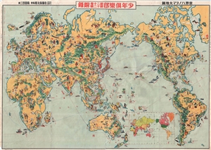
世界パノラマ大地圖 / World Panorama Daichi Sakai.
sold
- Digital Map Information
- Suitable for large format printing
- File Size: 38.48 MB
- File Type: ZIP / TIFF
- ICC color profile embedded
- Delivered instantly via download link
A remarkable 1933 Japanese issue pictorial map of the world drawn by Keizo Shimada (島田啓三). Centered on the Japanese Empire, which is highlighted in Red and includes both Taiwan and Korea, this map extends to cover the world with the exception of the Atlantic, which is only minimally addressed. The map presents a delightful array of vignettes intended to illustrate regional culture, flora, and fauna. Some of the images, despite being unbearably 'kawaii' are decidedly not politically correct, such as the rather intimidating looking Indian Chief in the Rocky Mountains. Despite the map's playful nature, Japan had already begun its grab for power in East Asia and the military aspect of the map is clear. Japanese destroyers patrol the western Pacific just as American destroyers stand watch on the Pacific Coast and in Hawaii. War was coming. (more details)
Japanese propaganda map of China from World War II.
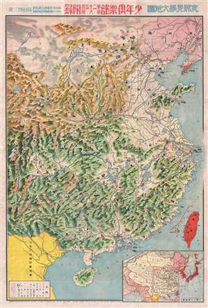
支那見學大地圖 / Large Map of China.
sold
- Digital Map Information
- Suitable for large format printing
- File Size: 33.48 MB
- File Type: ZIP / TIFF
- ICC color profile embedded
- Delivered instantly via download link
A rare 1938 Showa 13 World War II manga style propaganda map of China by the Japanese painter and manga artist Kato Takashiro. Published for the Japanese Youth Club or Shonan Club, this map illustrates all of China with manga style illustrations of Chinese workers ... (more details)
War Propaganda for kids.
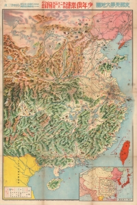
支那見學大地圖 / Large Study Map of China.
sold
- Digital Map Information
- Suitable for large format printing
- File Size: 82.41 MB
- File Type: ZIP / TIFF
- ICC color profile embedded
- Delivered instantly via download link
This is a rare 1938 (Showa 13) World War II or Second Sino-Japanese War manga-style propaganda map of China by a team of artists, printers, and editors led by Satō Yūtarō (佐藤裕太郎). Published for the magazine Youth Club (or Shōnen Club, 小年俱樂部), this map was meant to educate Japanese children about China and justify Japan's war there. (more details)
Fascinating manga map revealing Japanese ambitions prior to World War II.
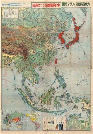
Greater East Asia Co Prosperity Panorama Map. / 大東亞共榮パノラマ地圖
sold
- Digital Map Information
- Suitable for large format printing
- File Size: 26.45 MB
- File Type: ZIP / TIFF
- ICC color profile embedded
- Delivered instantly via download link
This is a rare 1940 Showa 15 World War II manga style map of East Asia by the Japanese cartoonist Kato Takashiro (加藤隆四郎) and educator Yasutarō Satō (佐藤保太郎). Published by the Japanese Youth Club, the map illustrates all of East Asia, Southeast ... (more details)
Fascinating manga map revealing Japanese ambitions prior to World War II.
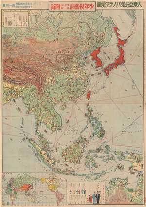
Greater East Asia Co Prosperity Panorama Map. / 大東亞共榮パノラマ地圖
sold
- Digital Map Information
- Suitable for large format printing
- File Size: 48.08 MB
- File Type: ZIP / TIFF
- ICC color profile embedded
- Delivered instantly via download link
This is a rare 1941 Showa 16 World War II manga style map of East Asia by the Japanese cartoonist Kato Takashiro (加藤隆四郎) and educator Yasutarō Satō (佐藤保太郎). Published by the Japanese Youth Club, the map illustrates all of East Asia, Southeast ... (more details)