
Mount and Page (sold)

Mount and Page (fl. 1701 - 1760) was a London based firm of religious and maritime publishers that flourished in the 18th century. With the publication of the 1732 English Pilot, the Mount and Page name became well-known worldwide as an imprint of nautical charts. The firm was founded at Tower Hill, London, in 1701 by Richard Mount (1654 - 1722) and his apprentice Thomas Page (1780 - March 15, 1733). Mount had previously been in partnership with his father-in-law William Fisher (1631 - 1691) and inherited the business on the latter's death. Page completed his apprenticeship in 1716. Now fully partnered, Mount and Page subsequently acquired the map plates several defunct British nautical chart publishers, including Greenville Collins, Jeremiah Seller, Charles Price, and John and Samuel Thornton - thus nearly monopolizing the British nautical chart business. The firm consequently received several lucrative government contracts and thereby flourished throughout the 18th century, making the fortunes of both families. Successive generations of Mounts and Pages worked in the business, and the families intermarried. Its staple titles were The English Pilot and Navigatio Britannica by John Barrow. By the 1760s, Richard Mount's grandson John Mount (1725 - 1786) was able to retire to Berkshire where he built the stately mansion, Wasing Place. John's son William (1753 - 1815) was the last to work in the map business, and later generations went into politics.
Very rare early map of the waters around Bombay (Mumbai).
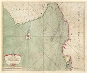
A large chart of part of the coast of GUZARATT and INDIA from Diu head to Bombay.
sold
- Digital Map Information
- Suitable for large format printing
- DPI: 600
- File Size: 19.99 MB
- File Type: ZIP / TIFF
- ICC color profile embedded
- Delivered instantly via download link
An extremely rare c. 1716 nautical chart or maritime map illustrating the Gujarat coast of India and the Gulf of Khambhat in the vicinity of Bombay or Mumbai. The map covers the coastline from, roughly Somnath and Diu to Vadodara, and south to Mumbai. The area now occupied by the Mumbai Peninsula is here divided into three islands, Tarma, Salset, and Bombay. Only one of these islands, Tarma, is connected to the mainland via a narrow bridge. On the southernmost island, Bombay is identified with the British flag, making this one of the earliest maps to illustrate Bombay following the 1661 British takeover. At sea, there are tenuous soundings and shadings around the shoals in the Gulf of Khambhat, also known as the Gulf of Cambay, and around Bombay itself. (more details)
A reformed 'Republic of Pirates'.
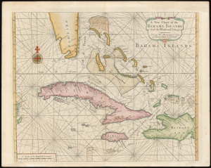
A New Chart of the Bahama Islands and the Windward Passage.
sold
- Digital Map Information
- Suitable for large format printing
- DPI: 600
- File Size: 20.26 MB
- File Type: ZIP / TIFF
- ICC color profile embedded
- Delivered instantly via download link
A rare 1737 map of the Bahamas, Florida, Cuba, and Jamaica issued by Mount and Page for the first edition of The English Pilot: The Fourth Book. The map, based upon a 1698 work by Samuel Thornton, illustrates the Bahamas during the 'Republic of Pirates' era (1698 - 1718), but has here been re-engraved by Mount and Page to capitalize on British interest in this region following increased Anglo-Franco-Spanish tensions surrounding the 1732 the founding of Georgia. (more details)
A scarce early map of the Entrance to the Chesapeake drawn from original survey work by Mark Tiddeman.
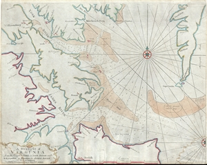
A Draught of Virginia from the Capes to York in York River and to Kuiquotan or Hamton in James River.
sold
- Digital Map Information
- Suitable for large format printing
- DPI: 300
- File Size: 13.39 MB
- File Type: ZIP / TIFF
- ICC color profile embedded
- Delivered instantly via download link
An important c. 1755 map of the Chesapeake Bay entrance by Mark Tiddemen. Oriented to the north, the map covers from the York River and Williamsburg to Norfolk and from Williamsburg to Cape Charles. It includes the mouths of the York River, The James River, the ... (more details)
Colonial era nautical chart of New York City and Harbor.
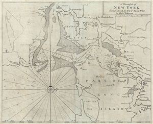
A Draught of New York from the Hook to New York Town.
sold
- Digital Map Information
- Suitable for large format printing
- DPI: 300
- File Size: 17.42 MB
- File Type: ZIP / TIFF
- ICC color profile embedded
- Delivered instantly via download link
A scarce and impressive colonial period c. 1773 Mark Tiddeman nautical chart of New York City and harbor. Oriented to the west and centered on Coney Island (Cunny I.), Tiddeman's chart coves from Staten Island to Jamaica Bay and from Sandy Hook to Harlem ... (more details)
Important Revolutionary war coastal chart of the Sea Islands in South Carolina, Georgia, and northern Florida.
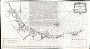
A Draught of South Carolina and Georgia from Sewee to St. Estaca.
sold
- Digital Map Information
- Suitable for large format printing
- DPI: 600
- File Size: 26.97 MB
- File Type: ZIP / TIFF
- ICC color profile embedded
- Delivered instantly via download link
A rare and important 1778 American Revolutionary War era Andrew Hughes nautical chart or maritime map of the coasts of South Carolina, Georgia, and northern Florida. During the early part of the Revolutionary War, this was the best obtainable nautical chart of the Sea Islands. Oriented to the east, this stunning map covers the Atlantic coast from the Santee River (Sewee River), South Carolina, past Charleston, Beaufort, and Savannah, to Saint Augustine, Florida. In addition, the map offers extensive and valuable piloting instructions addressing the entire coastline as well as most individual islands, including Tybee Island, Amelia Island, and Sapelo Island. It also includes excellent coverage of the region's shoals, anchorages, currents, marsh lands, river estuaries, and tides marks. (more details)
Important Revolutionary war coastal chart of the Sea Islands in South Carolina, Georgia, and northern Florida.
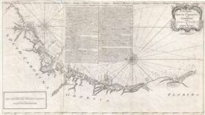
A Draught of South Carolina and Georgia from Sewee to St. Estaca.
sold
- Digital Map Information
- Suitable for large format printing
- DPI: 300
- File Size: 500.78 MB
- File Type: ZIP / TIFF
- ICC color profile embedded
- Delivered instantly via download link
A rare and important 1778 American Revolutionary War era Andrew Hughes nautical chart or maritime map of the coasts of South Carolina, Georgia, and northern Florida. During the early part of the Revolutionary War, this was the best obtainable nautical ... (more details)
Important Revolutionary war coastal chart of the Sea Islands in South Carolina, Georgia, and northern Florida.
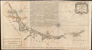
A Draught of South Carolina and Georgia from Sewee to St. Estaca.
sold
- Digital Map Information
- Suitable for large format printing
- DPI: 600
- File Size: 43.98 MB
- File Type: ZIP / TIFF
- ICC color profile embedded
- Delivered instantly via download link
A rare and important 1778 American Revolutionary War era Andrew Hughes nautical chart or maritime map of the coasts of South Carolina, Georgia, and northern Florida. During the early part of the Revolutionary War, this was the best obtainable nautical chart of the Sea Islands. Oriented to the east, this stunning map covers the Atlantic coast from the Santee River (Sewee River), South Carolina, past Charleston, Beaufort, and Savannah, to Saint Augustine, Florida. In addition, the map offers extensive and valuable piloting instructions addressing the entire coast line as well as most individual islands, including Tybee Island, Amelia Island, and Sapelo Island. It also includes excellent coverage of the region's shoals, anchorages, currents, marsh lands, river estuaries, and tides marks. (more details)
Scarce Revolutionary War Era map of the Atlantic - the sort that would have been used by merchants, pirates, slavers, and smugglers.
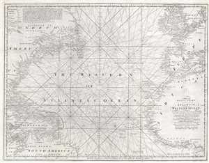
A New and Accurate Chart of the vast Atlantic or Western Ocean, including the Sea Coast of Europe and Africa on the East, and the opposite Coast of the Continent of America, and the West India Islands on the West; extending form the Equator to 59 Degrees North Latitude.
sold
- Digital Map Information
- Suitable for large format printing
- Full resolution TIFF file
- ICC color profile embedded
- Delivered instantly via download link
A rare 1778 nautical chart of the northern Atlantic Ocean by then English cartographer Emmanuel Bowen. The map covers from, roughly, the Arctic Circle to the Equator and from western Florida and Cuba to Sardinia and Denmark. Inland detail is minimal ... (more details)