
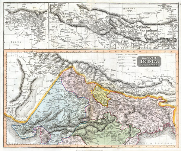
British India, Northern Part.
sold
- Digital Map Information
- Suitable for large format printing
- Full resolution TIFF file
- ICC color profile embedded
- Delivered instantly via download link
This fascinating hand colored 1814 map by Edinburgh cartographer John Thomson depicts northern India and Nepal. Bounded on the east by Persia and the Indus valley, on the North by Tibet, on the south by Berar, and on the east by Assam and Bhutan. Much of the upper ... (more details)

Colonies Francaises (en Afrique).
sold
- Digital Map Information
- Suitable for large format printing
- DPI: 300
- File Size: 9.02 MB
- File Type: ZIP / TIFF
- ICC color profile embedded
- Delivered instantly via download link
This is a fascinating 1852 Levasseur map of the French Colonies in Africa. The map area is divided into three sections dedicated to Senegambie (Senegambia), Madagascar, and the Senegal River. The largest of these focuses on Senegambia with an inset of the Island ... (more details)

Naples and Sicily.
sold
- Digital Map Information
- Suitable for large format printing
- DPI: 300
- File Size: 8.89 MB
- File Type: ZIP / TIFF
- ICC color profile embedded
- Delivered instantly via download link
This fascinating hand colored 1814 map by Edinburgh cartographer John Thomson depicts southern Italy ( Naples and Sicily). Covers from Rome south to the island of Sicily. Extraordinarily details with notations on both physical and political features. This map's ... (more details)

Hemisphere Occidental.
sold
- Digital Map Information
- Suitable for large format printing
- Full resolution TIFF file
- ICC color profile embedded
- Delivered instantly via download link
This is a rare and elegantly produced 1764 map of the Americas by French cartographer Louis Brion de la Tour. Depicts the whole of North and South America with several interesting cartographic features. The American northwest is largely ill defined though highly ... (more details)

Carte de l'Isle de Sainte Lucie.
sold
- Digital Map Information
- Suitable for large format printing
- DPI: 300
- File Size: 3.73 MB
- File Type: ZIP / TIFF
- ICC color profile embedded
- Delivered instantly via download link
This is an exceptionally fine example of the 1758 Jacques N. Bellin's map of St. Lucia (St. Lucie), in the Lesser Antilles, West Indies. Oriented to the east, this map covers the entire island of St. Lucia with topography rendered in profile. Some offshore ... (more details)

Tokyo
sold
- Digital Map Information
- Suitable for large format printing
- File Size: 11.44 MB
- File Type: ZIP / TIFF
- ICC color profile embedded
- Delivered instantly via download link
This extraordinary map is a hand colored Meiji Period woodcut representation of Tokyo. Produced in the late 19th century Japanese woodcut style, this map is a rare combination of practical and decorative. Offers a wealth of information from woodcut ... (more details)

Italie Partie Meridionale
sold
- Digital Map Information
- Suitable for large format printing
- Full resolution TIFF file
- ICC color profile embedded
- Delivered instantly via download link
This is a magnificent 1867 hand colored case map of Southern Italy, Naples, Sardinia, and Sicily. Produced by the well regarded mid 19th century French cartographer J. Andriveau0Goujon in Paris. The map is official entitled 'Italie Partie ... (more details)
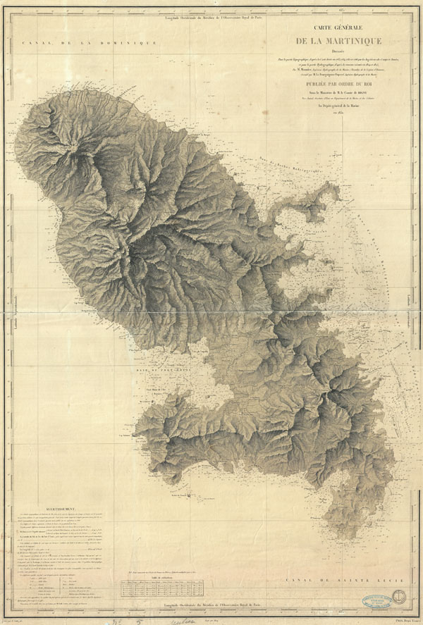
Carte Generale de la Maritinique.
sold
- Digital Map Information
- Suitable for large format printing
- DPI: 300
- File Size: 32.79 MB
- File Type: ZIP / TIFF
- ICC color profile embedded
- Delivered instantly via download link
A beautiful French nautical chart or map of Martinique issued in 1831 by the Depot de la Marine. Offers sumptuous detail both inland at sea. There are countess depth soundings as well as notes on undersea features such as banks and ... (more details)
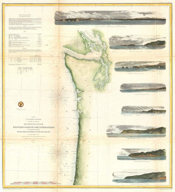
Reconnaissance of the Western Coast of the United States (Northern Sheet) from Umpquah River to the Boundary.
sold
- Digital Map Information
- Suitable for large format printing
- File Size: 13.93 MB
- File Type: ZIP / TIFF
- ICC color profile embedded
- Delivered instantly via download link
One of the most attractive coastal charts of the western United States. A rare hand colored 1855 coastal chart of the coastline of the United States Pacific Northwest, including the modern day states of Washington and Oregon. Map ... (more details)
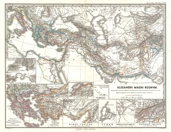
Alexandri Magni Regnum.
sold
- Digital Map Information
- Suitable for large format printing
- DPI: 300
- File Size: 7.4 MB
- File Type: ZIP / TIFF
- ICC color profile embedded
- Delivered instantly via download link
A fascinating 1854 historical map of the Empire of Alexander the Great. Shows Alexander's conquests at their fullest extent covering from Italy to the mouths of the Indus River and from the Black Sea to the Nile Valley. A series ... (more details)

Lake Champlain Sheet No. 2 from Cumberland Head to Ligonier Point.
sold
- Digital Map Information
- Suitable for large format printing
- File Size: 12.33 MB
- File Type: ZIP / TIFF
- ICC color profile embedded
- Delivered instantly via download link
A rare hand colored 1874 coastal chart of the northern part of Lake Champlain from Cumberland Head to Ligonier Point. Includes the cities of Burlington, Vermont and Plattsburgh, New York. The map features sailing instructions ... (more details)

Carte Particuliere Des Cotes d'Italie Grand Duche de Toscane partie comprise entre l'embouchure de L'Arno et le Cap Castiglioncello.
sold
- Digital Map Information
- Suitable for large format printing
- Full resolution TIFF file
- ICC color profile embedded
- Delivered instantly via download link
A beautiful French nautical chart or map issued in 1852 by the Depot de la Marine. Covers the Tuscan coastline from the mouth of the Arno River (Embouchure de L'Arno) to Cape Castiglioncello (just north of Pisa) with a focus ... (more details)

Tuscany and the States of the Church
sold
- Digital Map Information
- Suitable for large format printing
- Full resolution TIFF file
- ICC color profile embedded
- Delivered instantly via download link
This fascinating hand colored 1814 map by Edinburgh cartographer John Thomson depicts Tuscany and the Papal States in Italy. Depicts most of Central Italy from the Duchy of Parma in the north to Gaeta in the south. Overall ... (more details)
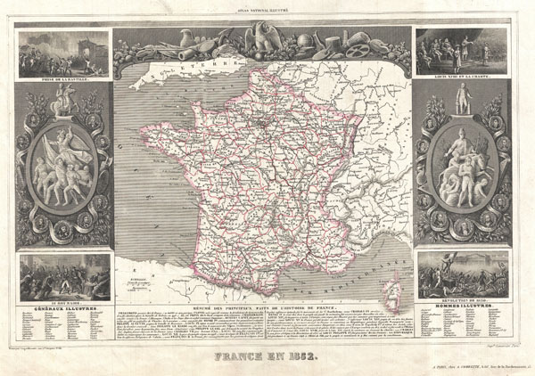
France en 1852.
sold
- Digital Map Information
- Suitable for large format printing
- Full resolution TIFF file
- ICC color profile embedded
- Delivered instantly via download link
This is a fascinating 1852 map of France. France was at this time voting to create the Second Empire under Napoleon III. The map proper is surrounded by elaborate decorative engravings designed to illustrate both the ... (more details)
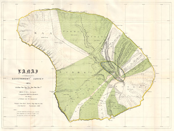
Lanai Government Survey.
sold
- Digital Map Information
- Suitable for large format printing
- File Size: 6.55 MB
- File Type: ZIP / TIFF
- ICC color profile embedded
- Delivered instantly via download link
This rare and extraordinary 1878 map of the island of Lanai, in the Hawaiian group, was prepared for the 1906 Report of the Governor of the Territory of Hawaii to the Secretary of the Interior. Though the ... (more details)

Dept. de la Charente Infre.
sold
- Digital Map Information
- Suitable for large format printing
- DPI: 300
- File Size: 9.03 MB
- File Type: ZIP / TIFF
- ICC color profile embedded
- Delivered instantly via download link
This is a fascinating 1852 map of the French department of Charente Inférieure (Charente Maritime), France. Charente Maritime is a coastal province border Charente, Dordogne, and Gironde (Bordeaux). It ... (more details)

Hindoostan.
sold
- Digital Map Information
- Suitable for large format printing
- DPI: 300
- File Size: 14.46 MB
- File Type: ZIP / TIFF
- ICC color profile embedded
- Delivered instantly via download link
A magnificent map and the rarest of the Thomson India series. This is the 1814 map of India with inset maps of the Ganges River by Edinburgh cartographer John Thomson. Depicts the whole of India from ... (more details)
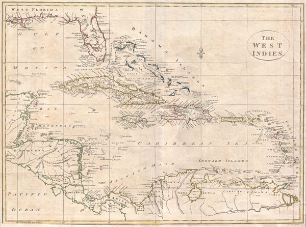
The West Indies.
sold
- Digital Map Information
- Suitable for large format printing
- Full resolution TIFF file
- ICC color profile embedded
- Delivered instantly via download link
A fine 1799 map of the West Indies by the English mapmaker Clement Cruttwell. Shows what was then known as West and East Florida, along with the Bahamas Islands, Cuba, Jamaica, Domingo, and Puerto ... (more details)

Extended Tape Indicator Map of London and Visitors Guide.
sold
- Digital Map Information
- Suitable for large format printing
- File Size: 25.21 MB
- File Type: ZIP / TIFF
- ICC color profile embedded
- Delivered instantly via download link
A large and attractive folding pocket format map of London England by C. Smith and son. This map is from the popular 'Tape Indicator' series that was published in numerous editions from the 1850 ... (more details)

China.
sold
- Digital Map Information
- Suitable for large format printing
- DPI: 300
- File Size: 8.38 MB
- File Type: ZIP / TIFF
- ICC color profile embedded
- Delivered instantly via download link
A fine 1799 map of China by the English mapmaker Clement Cruttwell. Includes the modern day provinces of Sichuan (Setchuen), Yunnan, Fujian (Fokien), Zchejiang (Tche Kiang), Honan (Henan), ... (more details)