
Extremely rare Amish or Pennsylvania Dutch allegorical broadside printed in Lancaster, PA.

Das ewige Leben und die ewige Verdammniss. (Eternal Life and Eternal Damnation)
sold
- Digital Map Information
- Suitable for large format printing
- DPI: 300
- File Size: 7.47 MB
- File Type: ZIP / TIFF
- ICC color profile embedded
- Delivered instantly via download link
A rare c. 1820 Amish or Pennsylvania Dutch allegorical fraktur or broadside illustrating the paths to heaven and hell. This broadside was issued in Lancaster, PA, by Herman W. Villee. The view appears to be a woodblock engraving. At the top, a grand city is ... (more details)
The first specific map of the west to appear in an American Atlas. Also, the only edition of this map to show the California Gold Region.
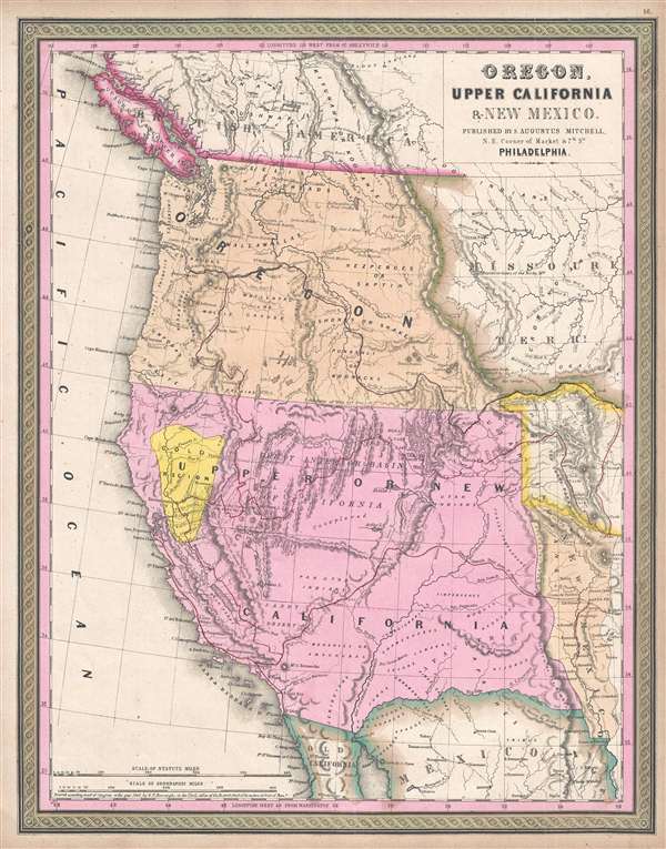
Oregon, Upper California, and New Mexico.
sold
- Digital Map Information
- Suitable for large format printing
- DPI: 300
- File Size: 6.24 MB
- File Type: ZIP / TIFF
- ICC color profile embedded
- Delivered instantly via download link
One of the most important mid-19th century American Atlas maps ever published, this is Samuel Augustus Mitchell's 1849 map of Upper California and Oregon, with a highlighted gold region. The map covers from Vancouver to the Mexico border and from the Pacific ... (more details)
Map of Texas at its fullest extand issued just before the Comprimise of 1850.
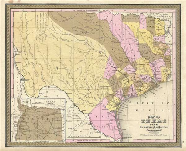
Map of Texas from the most recent authorities.
sold
- Digital Map Information
- Suitable for large format printing
- Full resolution TIFF file
- ICC color profile embedded
- Delivered instantly via download link
A fine example of the scarce 1849 Samuel Augustus Mitchell Map of Texas. Based upon the Tanner/Williams map of 1847, this map covers all of Texas according to the original 1836 claims of the Republic of Texas. This includes a vast territory extending from ... (more details)
A very early mapping of Iowa with vast American Indian territories and an early county structure.
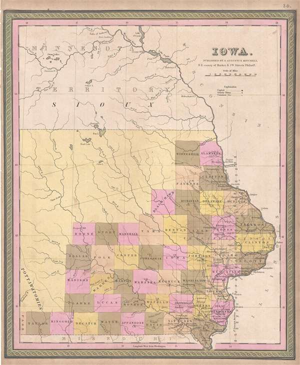
Iowa.
sold
- Digital Map Information
- Suitable for large format printing
- DPI: 300
- File Size: 4.84 MB
- File Type: ZIP / TIFF
- ICC color profile embedded
- Delivered instantly via download link
This is a Samuel Augustus Mitchell’s 1849 map of Iowa. The map covers the eastern parts of modern day Iowa with county platting limited to the southeastern quadrants. The remainder of the state depicted is devoted to American Indian Nations. The map ... (more details)
Exceptional World War II map printed in the International Settlement following the Japanese invasion of Shanghai, but before the occupiation of the Concessions - an ephemeral oasis of peace and prosperity in a war-torn city.
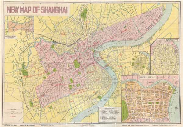
New Map of Shanghai.
sold
- Digital Map Information
- Suitable for large format printing
- File Size: 13.39 MB
- File Type: ZIP / TIFF
- ICC color profile embedded
- Delivered instantly via download link
This is an incredibly rare 1940 Shao Cheng city plan of the concessions in Shanghai, China during the Japanese occupation in World War II. Following the initial Japanese occupation of Shanghai, the Japanese avoided direct conflict with the ... (more details)
Monumental twelve panel map of Paris.

Plan De Paris, Leve Par Les Ordres Du Roy Et Par Les Soins De Messieurs Les Prevost Des Marchands Et Eschevins.
sold
This majestic twelve panel map or plan of Paris is the c. 1900 Taride reissue of an important map originally prepared by Pierre Bullet, Francois Blonde, A. Bonnardt, and Bernard J. H. Jaillot. Like many early maps of Paris, the present ... (more details)
Magnificent, iconic, and highly detailed twenty page wall map of Paris, France.

Plan de Paris.
sold
This is the c. 1900 Taride edition of Louis Bretez and Michel-Etienne Turgot's monumental 1739 map of Paris. Turgot's map of Paris is possibly the most ambitious urban mapping ever undertaken. This map shows the whole of 18th century Paris and offers a wonderful perspective on the city before Baron Georges Eugène Haussmann's 19th-century redesign. Turgot, who held the mayor-like office of Prevôt des Marchands de Paris , commissioned Louis Bretez and Claude Lucas to produce this map in 1734. Oriented to the east on an axonometric projection, this map is best understood as an aerial view where in every building, window, tree, shadow, and park are shown. It took the team nearly five years of exhaustive sketching and surveying to assemble this masterpiece. In order to produce the thousands of sketches and surveys required to complete this map, Bretez was issued a permit to enter every building in Paris. (more details)
Important map of the Philippines illustrating early proposed railroads.

Map of the Philippines.
sold
- Digital Map Information
- Suitable for large format printing
- File Size: 17.85 MB
- File Type: ZIP / TIFF
- ICC color profile embedded
- Delivered instantly via download link
A scarce and impressive large format map of the Philippines issued in 1905 to illustrate proposed rail lines. In 1905 the Second Philippine Commission, under William H. Taft, put forth a request for bids to build a series of modern ... (more details)
Stunning and rare Japanese Map of the East Indies.

[Untitled, Southeast Asia] 第一圖 / Map One.
sold
- Digital Map Information
- Suitable for large format printing
- File Size: 7.34 MB
- File Type: ZIP / TIFF
- ICC color profile embedded
- Delivered instantly via download link
A scarce Meiji 8, 1875 Japanese issue plan or map of Southeast Asia and the East Indies. Centered on the Mekong River, this map covers from Taiwan to Java and from Pegu (Burma) to the Philippines, including all of modern day ... (more details)
Remarkable 1869 map or plan of Prospect Park, Brooklyn.

Design for Prospect Park in the City of Brooklyn.
sold
- Digital Map Information
- Suitable for large format printing
- File Size: 5.63 MB
- File Type: ZIP / TIFF
- ICC color profile embedded
- Delivered instantly via download link
This is a rare 1869 edition of Calvert Vaux and Frederick Law Olmsted's map of Prospect Park, Brooklyn. The map depicts the park as a whole and includes pathways, lakes, buildings, individual trees, rocks, and elevation ... (more details)
Impressive pocket map of 1940s St. Louis.
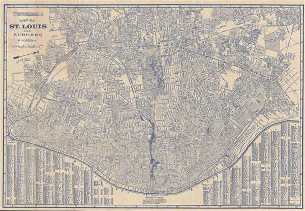
Map of St. Louis and Suburbs.
sold
- Digital Map Information
- Suitable for large format printing
- Full resolution TIFF file
- ICC color profile embedded
- Delivered instantly via download link
This is an impressive 1943 pocket map of St. Louis, Missouri, by H. W. Gross. This map, part of the 'City Guide and Map of St. Louis' tourist guide book, is centered on Forest Park and covers central St. Louis from the ... (more details)
A spectacularly engraved view of Ancient Jerusalem.

A Bird's Eye View of Ancient Jerusalem, Embracing a Minute Representation of this Sacred City.
sold
- Digital Map Information
- Suitable for large format printing
- DPI: 300
- File Size: 10.91 MB
- File Type: ZIP / TIFF
- ICC color profile embedded
- Delivered instantly via download link
This is an 1853 Frederick Gleason bird's-eye view of ancient Jerusalem. It is a pictorial reconstruction of the ancient city of Jerusalem, using both Old and New Testament sites. The view is oriented toward the west, ... (more details)
Map of the first European expedition to cross the Sahara from north the south.
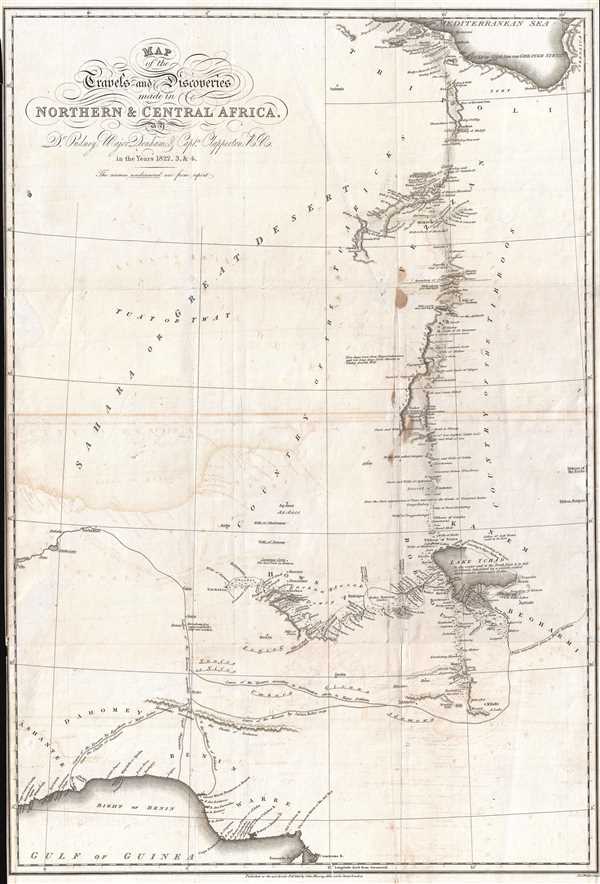
Map of the Travels and Discoveries Made in Northern and Central Africa by Dr. Oudney, Major Denham, and Capt. Clapperton, R.N.
sold
- Digital Map Information
- Suitable for large format printing
- DPI: 300
- File Size: 7.15 MB
- File Type: ZIP / TIFF
- ICC color profile embedded
- Delivered instantly via download link
This is a scarce and intriguing 1826 map of North and Central Africa. The map depicts parts of Libya, Chad, Nigeria, and Benin, as well as several other African nations, although no 'international' borders are ... (more details)
Pre Civil War map of South Carolina.

A New Map of South Carolina with its Canals, Roads and Distances from place to place, along the Stage and Steam Boat Routes.
sold
- Digital Map Information
- Suitable for large format printing
- DPI: 300
- File Size: 6.02 MB
- File Type: ZIP / TIFF
- ICC color profile embedded
- Delivered instantly via download link
This is a beautiful example of Samuel Augustus Mitchell's important 1849 map of South Carolina. This map shows cities, topographical features, railways, ferries and roads with color coding at the county level. ... (more details)
Illustrates the site of North America's first Gold Rush.

A New Map of Nth. Carolina with its Canals, Roads and Distances from place to place, along the Stage and Steam Boat Routes.
sold
- Digital Map Information
- Suitable for large format printing
- DPI: 300
- File Size: 5.98 MB
- File Type: ZIP / TIFF
- ICC color profile embedded
- Delivered instantly via download link
This is an important 1849 map of North Carolina by Samuel Augustus Mitchell. This map shows cities, topographical features, railways, ferries and roads with color coding at the county level. In addition to ... (more details)
Incredibly detailed city map of Washington, D.C. at the beginning of American involvment in World War I
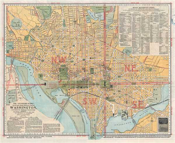
The 'Standard Guide' Ready Reference Map of Washington, to accompany the 'Washington Standard Guide'.
sold
- Digital Map Information
- Suitable for large format printing
- File Size: 11.84 MB
- File Type: ZIP / TIFF
- ICC color profile embedded
- Delivered instantly via download link
This is an appealing 1917 map or plan of Washington, D.C. by the Foster and Reynolds Company of New York. It covers Washington D.C. from the Arlington National Cemetery eastward as far as 28th Street and ... (more details)
19th Century Japanese Map of Bangkok - very rare!

第四圖 / The Fourth Map.
sold
- Digital Map Information
- Suitable for large format printing
- File Size: 1.21 MB
- File Type: ZIP / TIFF
- ICC color profile embedded
- Delivered instantly via download link
A scarce Meiji 8, 1875 Japanese issue map of the Chao Phraya River from the Bay of Bangkok to the city of Bangkok. Bangkok is depicted on the upper right with some detail, including the city's canal ... (more details)
Beautiful comparative mountains and river charts from the mid-19th century.

Lengths of the Principal Rivers in the World. Heights of the Principal Mountains in the World.
sold
- Digital Map Information
- Suitable for large format printing
- DPI: 300
- File Size: 7.51 MB
- File Type: ZIP / TIFF
- ICC color profile embedded
- Delivered instantly via download link
This is the scarce 1849 Samuel Augustus Mitchell Comparative Mountains and Rivers Charts. Mitchell based his Mountains and Rivers Chart on a nearly identical map first prepared by the American ... (more details)
Map of the United States illustrating trans-continental emigrant routes and the California Gold Rush.
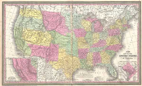
A New Map of the United States of America.
sold
- Digital Map Information
- Suitable for large format printing
- DPI: 300
- File Size: 15 MB
- File Type: ZIP / TIFF
- ICC color profile embedded
- Delivered instantly via download link
This is an example of Samuel Augustus Mitchell's 1854 map of the United States. Issued shortly following the California Gold rush, this map covers the United States from coast to coast, ... (more details)
Uncommon 1799 map of the Chesapeake Bay.
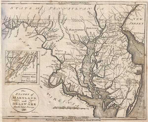
The States of Maryland and Delaware from the latest surveys. 1799.
sold
- Digital Map Information
- Suitable for large format printing
- DPI: 300
- File Size: 1.98 MB
- File Type: ZIP / TIFF
- ICC color profile embedded
- Delivered instantly via download link
This is a 1799 John Payne map of Maryland and Delaware. The map depicts the Chesapeake Bay region from Fort Cumberland on the Potomac River to Delaware Bay and New Jersey and from ... (more details)