
Early map of Africa depicting Lake Malawi almost 100 year prior to its discovery.

L'Afrique divisee en ses Principaux Etats.
sold
- Digital Map Information
- Suitable for large format printing
- DPI: 300
- File Size: 7.3 MB
- File Type: ZIP / TIFF
- ICC color profile embedded
- Delivered instantly via download link
A fine example of Jean Janvier's 1762 map of Africa. Janvier's map covers the entire continent of Africa as well as the island of Madagascar and adjacent parts of Europe, Arabia, and Persia. Like most 18th century maps of Africa, the present example is rife with ... (more details)
Early nautical map depicting the Gulf of Mexico including Florida, Central America and the West Indies.

Carte geo-hydrographique du Golfe du Mexique et de ses isles.
sold
- Digital Map Information
- Suitable for large format printing
- DPI: 300
- File Size: 8.68 MB
- File Type: ZIP / TIFF
- ICC color profile embedded
- Delivered instantly via download link
This is a beautiful example of Zannoni's 1783 map of the West Indies, Florida and Central America. It covers from the Gulf of Mexico to the Lesser Antilles including all of the West Indies, Florida and Central America, with parts of Louisiana, Mexico and ... (more details)
Decorative map depicting the twelve Tribes of Israel.
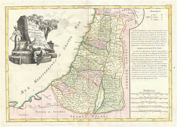
Carte des Douze Tribus d'Israel.
sold
- Digital Map Information
- Suitable for large format printing
- DPI: 300
- File Size: 7.4 MB
- File Type: ZIP / TIFF
- ICC color profile embedded
- Delivered instantly via download link
This is a beautiful example of Rigobert Bonne's 1783 map of Israel (Palestine / Holy Land) divided according to the Biblical Twelve Tribes of Israel. Bonne's map covers Palestine or Israel on both sides of the Jordan River from Sidon to Gaza and Zoara ... (more details)
Fascinating document illustrating Bruce's rediscovery of the source of the Blue Nile and his travels in the Red Sea.
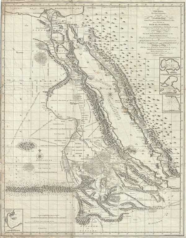
To The King. This map, Containing a Chart of the Arabian Gulf With its Egyptian, Ethiopian and Arabian Coasts, from Suez to Bab el Mandeb, A Journey through Abyssinia to Gondar, its Capital, From thence to the Source of the Nile, The Whole of that River, from its Source to the Mediterranean, Now first laid down from Astronomical Observations of All those points necessary to Aseertain the form of its Course, Teh Return by Sennaar and the Great Desert of Nubia and Beja All laid down by Actual Survey with the largest and most perfect Instruments now in use by His Majesty's most dutiful and faithful Subject & Servant, James Bruce.
sold
- Digital Map Information
- Suitable for large format printing
- DPI: 300
- File Size: 21.01 MB
- File Type: ZIP / TIFF
- ICC color profile embedded
- Delivered instantly via download link
This is a fascinating, significant, beautifully engraved, intricately detailed 1790 map of Egypt, Abyssinia, and the Red Sea by the Scottish adventurer James Bruce. Centered on the Nile Valley, this map covers all of Egypt, Abyssinia, and the Red Sea ... (more details)
Official Chamber of Commerce map of San Francisco.
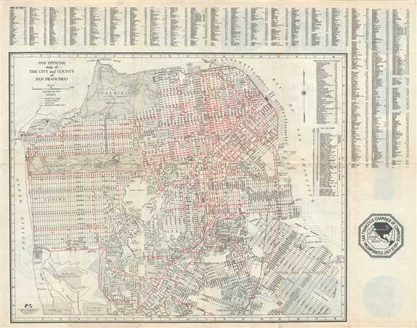
1928 Official map of The City and County of San Francisco.
sold
- Digital Map Information
- Suitable for large format printing
- File Size: 15.26 MB
- File Type: ZIP / TIFF
- ICC color profile embedded
- Delivered instantly via download link
This is a lovely 1928 pocket map or plan of the city of San Francisco, California by the W. C. Eubank Company. It covers San Francisco from the Lakeside Golf Club in the south to Fort Winfield Scott in the north and to Water Front Street in the east ... (more details)
Beautiful city plan of Cleveland, Ohio.
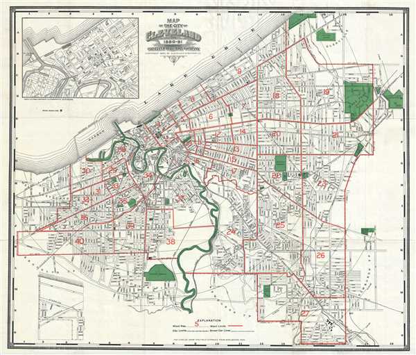
Map of the City of Cleveland for 1890-91.
sold
- Digital Map Information
- Suitable for large format printing
- File Size: 21.52 MB
- File Type: ZIP / TIFF
- ICC color profile embedded
- Delivered instantly via download link
This is a beautiful 1890 map of the city of Cleveland, Ohio issued by the Cleveland Directory Company. The map extends southward from Lake Erie and covers the entire city of Cleveland at the time, centered on the Cuyahoga River. An inset in the top ... (more details)
Chart showing the progress of a total solar eclipse.
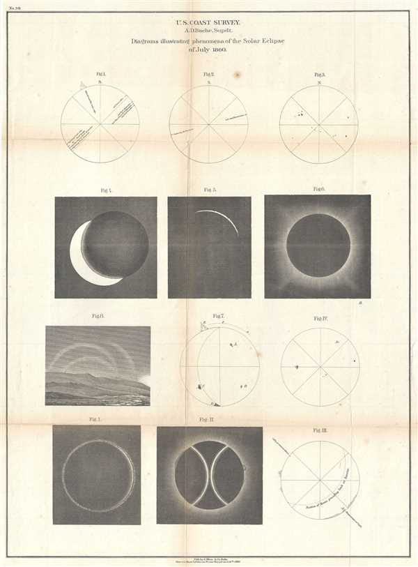
Diagrams illustrating phenomena of the Solar Eclipse of July 1860.
sold
- Digital Map Information
- Suitable for large format printing
- File Size: 9.81 MB
- File Type: ZIP / TIFF
- ICC color profile embedded
- Delivered instantly via download link
This is a lovely 1860 chart issued by the U.S. Coast Survey illustrating the Solar Eclipse of July 1860. When the moon passes between the Sun and the Earth and completely covers the Sun’s disk, blocks the Sun, it results in a total Solar Eclipse. ... (more details)
Beautifully detailed chart of the Gulf Stream.
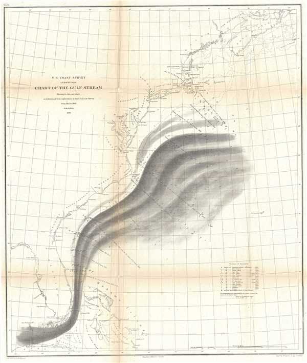
Chart of the Gulf Stream.
sold
- Digital Map Information
- Suitable for large format printing
- File Size: 9.5 MB
- File Type: ZIP / TIFF
- ICC color profile embedded
- Delivered instantly via download link
This is a beautiful 1860 U.S. Coast Survey map or chart of the Gulf Stream. The map covers the eastern coast of the United States from Florida north as far as Nova Scotia and shows the axis and limits of the Gulf Stream. Several capes, islands, ... (more details)
Beautiful coast survey chart showing the geology of Labrador, Canada.

Sketch Showing the Geology of the Coast of Labrador.
sold
- Digital Map Information
- Suitable for large format printing
- File Size: 5.46 MB
- File Type: ZIP / TIFF
- ICC color profile embedded
- Delivered instantly via download link
This is a beautiful 1860 map or chart showing the geology along the coast of Labrador in the Canadian province of Newfoundland and Labrador issued by the U.S. Coast Survey. The chart shows the distribution of the different types of rocks or ... (more details)
Early Coast Survey chart of San Diego Bay.

J No. 7 San Diego Entrance and Approaches California. General Sketch of San Diego Bay and Los Coronados.
sold
- Digital Map Information
- Suitable for large format printing
- DPI: 300
- File Size: 4.3 MB
- File Type: ZIP / TIFF
- ICC color profile embedded
- Delivered instantly via download link
This is a lovely 1851 U.S. Coast Survey chart or map of San Diego Bay. It features essentially two maps in one chart separated by a compass rose. The first map shows San Diego bay and Harbor just south of the city of San Diego. The ... (more details)
Beautiful map charts the entire coast of the United States, including the Atlantic Coast, the Gulf Coast and the Pacific Coast.

Sketch Showing the Progress of the Survey on the Atlantic Gulf of Mexico and Pacific Coast of the United States.
sold
- Digital Map Information
- Suitable for large format printing
- File Size: 12.78 MB
- File Type: ZIP / TIFF
- ICC color profile embedded
- Delivered instantly via download link
This is a beautiful 1860 U.S. Coast Survey map or chart of the coast of the United States. The map covers the Atlantic Coast, the Gulf Coast and the Pacific coasts in beautiful detail. Divided into two sections, the large area extends ... (more details)
Unusual chart of the coasts of New Jersey and Delaware.

Coast Chart No. 27 From Cape May to Isle of Wight.
sold
- Digital Map Information
- Suitable for large format printing
- File Size: 18.31 MB
- File Type: ZIP / TIFF
- ICC color profile embedded
- Delivered instantly via download link
This is a c.1860 U.S. Coast Survey chart of the coast of New Jersey’s Cape may to Isle of Wight in Maryland. It depicts part of the Atlantic Ocean near the mouth of the Delaware Bay and extends from Turtle Gut inlet south to ... (more details)
Coast Survey chart of the San Francisco Bay Area.

(J bis) Sketch J Showing the Progress of the Survey in Section No. X (Middle Sheet) From Pt. Sal to Tomales Bay.
sold
- Digital Map Information
- Suitable for large format printing
- File Size: 6.1 MB
- File Type: ZIP / TIFF
- ICC color profile embedded
- Delivered instantly via download link
This is an uncommon example of the 1860 U.S. Coast Survey progress and triangulation chart or map of the coast of California from Point Sal to Tomales Bay, including Monterrey Bay, Drakes Bay, and of course, San Francisco Bay ... (more details)
Nautical Chart of Currituck Sound and North Landing River with intricate inland details.

Preliminary Chart of North Landing River (Head of Currituck Sound) Virginia and N. Carolina
sold
- Digital Map Information
- Suitable for large format printing
- File Size: 8.64 MB
- File Type: ZIP / TIFF
- ICC color profile embedded
- Delivered instantly via download link
This is an appealing 1861 U.S. Coast Survey nautical chart or maritime map of North Landing River and Currituck Sound in Virginia and North Carolina. The map covers from Currituck northward to North Landing River. Shows ... (more details)
Beautiful nautical chart detailing the coastline of Oregon and Washington.

Sketch J No. 13 Reconnaissance of the Western Coast of the United States from Monterey to the Columbia River in three sheets Sheet No. 3.
sold
- Digital Map Information
- Suitable for large format printing
- DPI: 300
- File Size: 5.39 MB
- File Type: ZIP / TIFF
- ICC color profile embedded
- Delivered instantly via download link
This is an attractive 1851 U.S. Coast Survey chart of the Washington and Oregon Coast. It covers from Cape Arago in Oregon north to the Columbia River and includes Astoria, Cape Lookout, Cape Foulweather and Cape ... (more details)
Beautiful nautical chart detailing the coastline of California and Oregon.

Sketch J No. 13 Reconnaissance of the Western Coast of the United States from Monterey to the Columbia River in three sheets Sheet No. 2.
sold
- Digital Map Information
- Suitable for large format printing
- DPI: 300
- File Size: 6.74 MB
- File Type: ZIP / TIFF
- ICC color profile embedded
- Delivered instantly via download link
This is an attractive 1851 U.S. Coast Survey chart of the California and Oregon Coast. It covers from Cape Mendocino north to Umpqua Head and includes Trinidad City and Eureka. This map is the second sheet of ... (more details)
Beautiful nautical chart of the California coastline with coastal views.
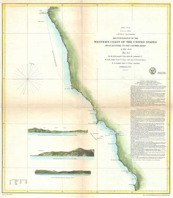
Sketch J No. 12 Reconnaissance of the Western Coast of the United States from Monterey to the Columbia River in three sheets Sheet No. 1.
sold
- Digital Map Information
- Suitable for large format printing
- DPI: 300
- File Size: 6.5 MB
- File Type: ZIP / TIFF
- ICC color profile embedded
- Delivered instantly via download link
This is an attractive 1851 U.S. Coast Survey chart of the California Coast. It covers from Monterey Bay north to Cape Mendocino and includes San Francisco Bay. This chart is the first sheet of three, which ... (more details)
Beautifully detailed chart showing the triangulation of the coast of Georgia and South Carolina.

Sketch E Showing the Progress of the Survey in Section No. V from 1847 to 1859.
sold
- Digital Map Information
- Suitable for large format printing
- File Size: 15.13 MB
- File Type: ZIP / TIFF
- ICC color profile embedded
- Delivered instantly via download link
This is an appealing 1859 U.S. Coast Survey triangulation chart or map of the Georgia and South Carolina coastline from Cumberland Island to Bald Head Island in North Carolina. Essentially three maps on a ... (more details)
Beautiful early map of Africa notes a speculative Lake Maravi and Mountains of the Moon.
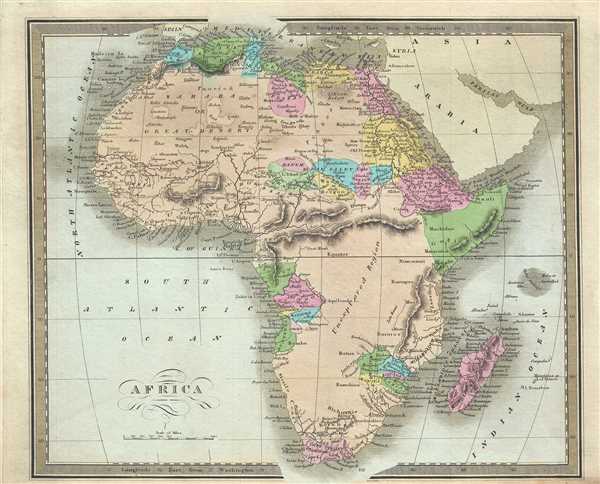
Africa.
sold
- Digital Map Information
- Suitable for large format printing
- DPI: 300
- File Size: 5.97 MB
- File Type: ZIP / TIFF
- ICC color profile embedded
- Delivered instantly via download link
An interesting example of the 1834 first edition map of Africa by David H. Burr. This is an early 19th century and historically important representation of the continent of Africa. Nineteenth century ... (more details)
One of the eariest maps to accurately show the true Northwest Passage.

North America.
sold
- Digital Map Information
- Suitable for large format printing
- DPI: 300
- File Size: 5.62 MB
- File Type: ZIP / TIFF
- ICC color profile embedded
- Delivered instantly via download link
This is a beautiful example of the 1834 first edition map of North America by David H. Burr. Burr’s map covers the entire North American continent from the Arctic Circle to the Isthmus of Panama, ... (more details)